For over a century, global discovery and consumption of crude oil rose steadily, with increasing demand mirrored by increasing potential supply. Then, in the 1970s the world experienced what many at the time considered “peak oil,” at which point fossil fuel demands continued to rise while production volumes of the world’s oil leveled off and began to decline [1, 2]. While production eventually recovered from the 1970s “peak,” over the upcoming decades conventional oil production is projected to continue its downward trend while consumption is predicted to continue on its upward trajectory for at least a decade and maybe more, despite the international commitments made in Paris [3] (Figure 1). With the readily accessible fossil fuel resources in decline, how will future global energy demands be met? Many countries that border the Arctic isotherm believe that the answer lies beneath the waters at their coastlines, where a large portion of the world’s remaining oil reserves are located.
In the United States, like the rest of the world, the declining hydrocarbon industry is vitally dependent on transportation infrastructure to move resources. Hundreds of miles of lands are cleared with the express purpose of building roadways and pipelines to transfer oil and gas from drill sites to refineries, then further down the supply chain to distribution nodes. Pipelines make distant resources attainable, while simultaneously turning mere wilderness into territory, projecting the power of the state across vast and sparsely settled territories for the purpose of extraction. Few places have had as much of their identity and economic history tied to the creation of a single piece of pipeline infrastructure as Alaska. The Trans-Alaska Pipeline radically transformed the economy of Alaska, both during the boom that accompanied its construction, and the subsequent massive infusion of revenue that oil production has injected into the state every year since.
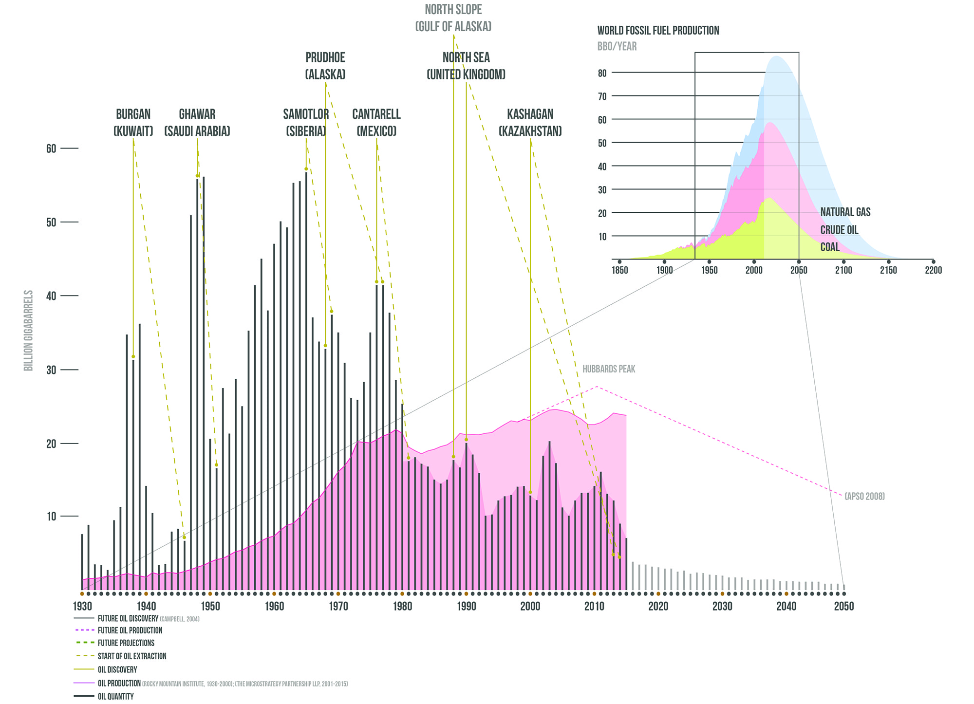
Figure 1. World Oil Discoveries. A graph of discovered oil reserves juxtaposed against past and an approximation of projected production volumes (‘The Hubbert Curve’). All images by Michael W. Smith
In this moment of climate crisis, however, what does the future of Alaska’s relationship to its pipeline, and to the places fueling the hydrocarbon economy, look like? Can this single-use infrastructure be turned into a mechanism to usher in a renewable future for Alaska, and to function as a device that might help support the economy of the places that it formerly bypassed?
The Crude North is an exploration into uncertain trajectory of Alaska’s energy future through the manipulation of policy and infrastructure easements along the Trans-Alaska pipeline. The heart of this design investigation focuses on transforming the single-use infrastructure of the pipeline itself into a mechanism that can support local economic development and ultimately lead to a sustainable future economy.

Figure 2. U.S. Crude Oil Field Production & Oil Rig Deployment. This shows the volume of oil production and the increased rig deployments across oil fields to satisfy consumption demands.
Hydrocarbon Territory
Despite having some of the largest oil reserves in the world, America’s continental oil fields are slowing down and drying up. US oil production has been prolific since the early 1900s; the contiguous United States holds an estimated total of 24 billion barrels of oil (BBO) and 750 trillion cubic feet of gas (TCF) in underground reserves [4]. However, the reality is that until the fracking boom of the last decade, the country’s crude oil resources have been in steady decline since the 70s [5]. In the last decade, the number of oil rigs put into use across U.S. shale formations has increased exponentially as riggers try to extract as much oil as possible from dwindling reserves (Figure 2 & 3). The American Association of Petroleum Geologists acknowledges that the United States is “preeminent among nations in the manufacturing of oil well machinery and apparatus” [6]. Contemporary oil drilling machines have the ability to burrow horizontally under the earth to find pockets of formerly inaccessible “tight oil” between strata [7]. These drilling strategies yield temporary increase in supply all the while depleting remaining finite resources at an accelerated rate. Despite advances in drilling technology and extensive financial interest in oil and gas infrastructure in the lower 48, with its estimated remaining resources declining, the United States oil industry must look elsewhere for future energy resources.
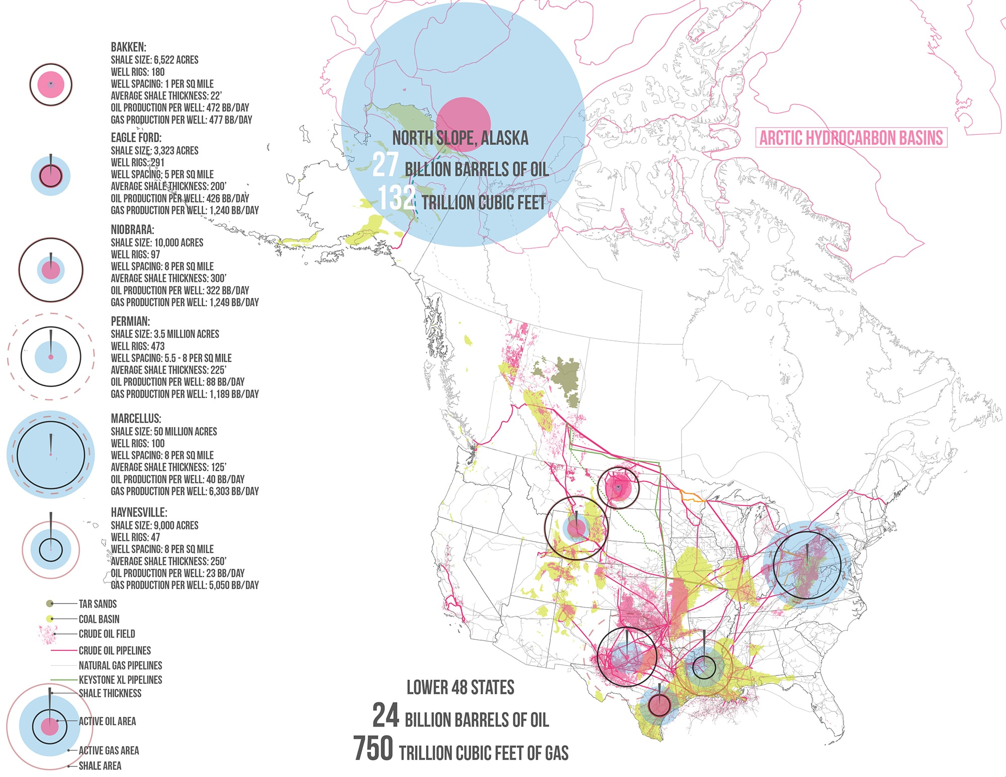
Figure 3. North American Fossil Fuel Atlas. The North Slope of Alaska has hydrocarbon reserves rivaling the total volumes of the lower 48 states. The increasing access to extracting these resources is putting increased pressure on Alaska.
In 1968, a concentrated untapped volume of hydrocarbons was discovered off the coast of Alaska that rivals the total remaining resources in the rest of the country. An estimated 27 BBO of oil and 132 TCF of gas is located a few miles off the north coast of Alaska in relatively shallow US territorial waters [8] — more oil than is estimated beneath all oil reserves of the lower 48 states combined. Though abundant, extraction of this offshore oil is challenging, as it is disconnected from major refineries and markets.
Climate is a major consideration that has significant impacts on any industrial process in the Arctic. On Alaska’s North Slope winter temperatures commonly drop below 30°F and daylight lasts as little as 2 hours per day around the winter solstice. Between the low light availability, harsh winter temperatures and the encroaching sea ice, oil operations are limited for nearly half the year, resulting in harsh working conditions and seasonal employment.
Despite these challenges, technically speaking, drilling for hydrocarbons in Alaska’s shallow seas is one of the few positives for the oil industry. North Slope extraction is significantly less resource-intensive than in deeper waters such as the Gulf of Mexico. The geological construct of the North Slope continental shelf is less complex, and the depth of the seafloor is only 150 feet deep on average compared the Gulf’s 5000 feet [9]. The subsurface pressures in the North Slope are also relatively low compared to typical offshore wells, making extraction theoretically safer [10].
In recent years, an erosion in both the thickness and extent of sea ice, combined with various and technological innovations, are making the extraction of oil more alluring to governments and private companies. This phenomenon can be partially attributed to climate change — increasing seasonal access to the seafloor as well as longer accessibility to navigable waterways is making drilling for oil here much more financially appealing — a trend that will only intensify as Arctic sea ice continues to melt.
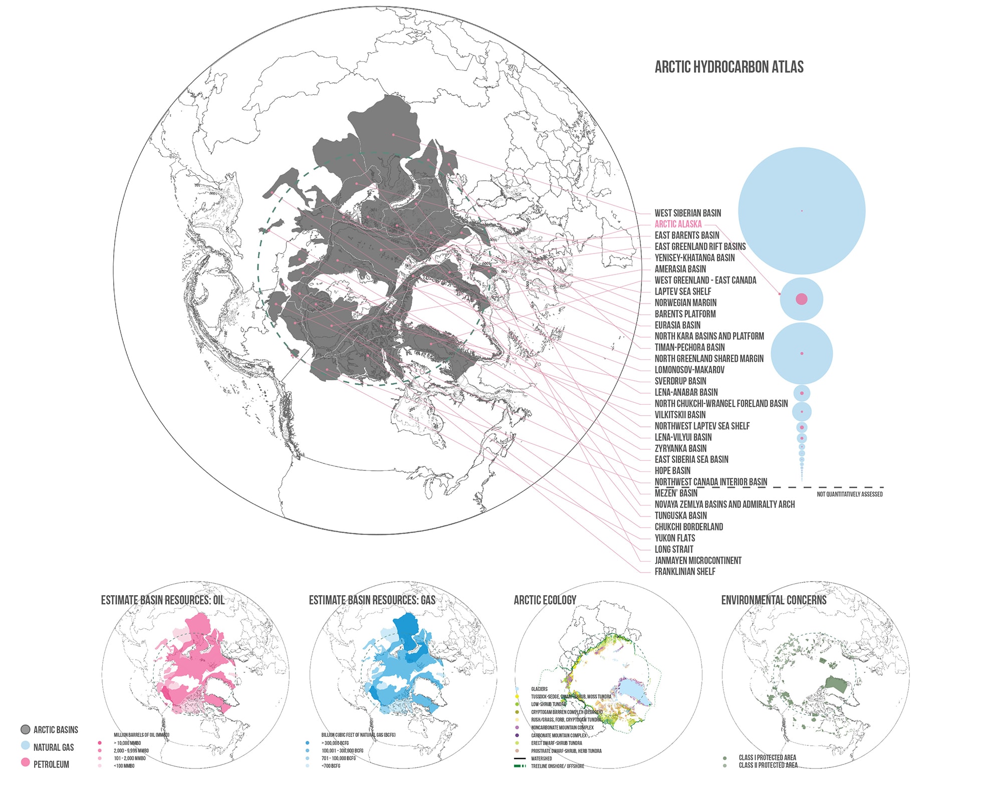
Figure 4. The Race for Arctic Hydrocarbons. There are over 30 significant hydrocarbon basins in the Arctic with varying amounts of natural gas and crude oil. Of these discovered basins, 25 have substantial reserves available for extraction [12].
The Crude North is an investigation of potential scenarios related to the future of crude oil extraction across this territory. Today, we find settlements clustered around pipeline pumping stations and depots that began as hubs dating back to the Trans-Alaska pipeline’s construction. Pipeline segments between settlements and abandoned construction camps are in need of repair as a result of shifting permafrost zones and aging infrastructure. The Crude North project reimagines the Trans-Alaskan Pipeline as an energy armature that might be expanded to accommodate future oil and gas extraction while simultaneously providing a more economically and environmentally sustainable future for the state.
No territory in the United States exhibits a bigger tension between resource extraction and conservation of public lands than the North Slope of Alaska. The U.S. government has endorsed drilling off Alaska’s North Slope since 2015 [13]. Since the early 2000’s Alaskan Native groups have largely endorsed the oil and gas exploration there, advocating for job creation and economic development [14]; however, other indigenous groups like the Gwich’in, who subsist on Caribou hunting, have fiercely fought oil development in the North Slope. The indigenous populations of the North Slope don’t have the technical skills to compete with foreign engineers in providing labor for the extraction process. Alaskans need a sustainable solution to support the local economy during the next oil boom and to continue to thrive after post-peak production.
This project assumes that some North Shore oil extraction will take place regardless of current political and environmental pressures. If this prediction is valid, how then, should this extraction process be orchestrated, with deference to environmental considerations while finding a way to support the energy and economic needs of the community when the oil stops flowing? Alaska has an opportunity to leverage what is left of its hydrocarbon resources to support the subsequent energy infrastructure and do it in a way that prevents the cyclical boom and bust cycle associated with energy extraction.

Figure 5. Crude Oil & Coal Deposits in the U.S. Arctic Territory. The oil reserves off Alaska’s coastlines are adjacent to the north end of the Trans-Alaska Pipeline. This existing oil infrastructure and its right-of-way has the capacity to endure the burden of future oil extraction from North America’s Arctic basins.
BOOM and BUST
To understand how future oil development might play out after the coming oil boom on the North Slope, we can look back towards what has happened in Alaska’s past: in previous boom-bust cycles the population in Alaska has grown and shrunk in response to activity in the state’s oil plays [15]. In the 1970s migrant workers were deployed across Alaska’s landscape to build the Trans-Alaska Pipeline, a phenomenon that effectively doubled the state’s population at that time. After peak oil, the population rapidly fell, leaving behind abandoned infrastructure and an unstable economy. The onshore oil industry at the North Slope today buttresses the state’s revenues, but currently, onshore oil revenues are declining due to the reduction of onshore oil and gas field production. Like many of America’s oil wells over the past century, the wells here in Alaska are also drying up. The Trans-Alaska pipeline that once supplied America with between 20% and 25% of its crude oil is now flowing at approximately 1/3 the volume [16].
The onshore oil industry of the North Slope Borough has historically contributed up to 80% of Alaska’s unrestricted state revenues through taxes on oil infrastructure [17]. Currently, these onshore oil revenues are declining due to the reduction of onshore oil and gas field production. Like many of America’s early wells, Alaska’s wells are drying up [18].
But the offshore development in the North Slope is set to change this dynamic, and usher in a new boom. Alaska is once again about to experience a large and expeditious increase in population because of the impending petroleum extraction in the Arctic. The peak oil extraction in northern Alaskan seas are expected to take place in approximately 15 to 20 years [19]. The current baseline population predictions in Alaska are expected to naturally rise from 714,142 to 915,211 (a 13% increase) [20]. This estimate does not include projections related to the rapid expansion of the petroleum industry. Based on previous fluctuations related to hydrocarbon extraction here and to evaluated reserves, we can estimate that the increase may be 2-5 times larger than current projections. A portion of this population, however, will be transient and temporary. How can population growth projections alter the way we think about installing and positioning future oil?

Figure 6. Alaska Oil Migration/ Future Offshore Oil Boom. Alaska has seen massive migratory shifts with the ebb and flow of the oil industry. Because of this clear documentation in the past It’s easy to predict how this will play out across the next oil epoch.
The Pipeline
When built, the extracted hydrocarbons will travel along the proposed Keystone XL pipeline. Various proposals suggest that the 48” diameter pipeline shall run adjacent to the Trans-Alaska pipeline from Prudhoe Bay, connecting to the Trans-Canada pipeline in Southwestern Yukon [21]. The 1,179 miles of pipeline would bridge the offshore North American basins and the oil fields in Alberta to the refineries in the United States. The pipeline is associated with a 100-foot right-of-way, the creation of which involves cutting and clearing of hundreds of acres of forest under the jurisdiction of the Bureau of Land Management (BLM) [22].
To facilitate the future hydrocarbon operations off the North Slope, the Keystone pipeline will be built directly adjacent to the Trans-Alaska pipeline, reactivating the dormant camps that previously provided a base of operations for the Trans-Alaska pipeline workers [23] (Figure 10). Today many of these stations are abandoned. Reactivating these sites, which are linked by transportation infrastructure, is an opportunity to couple existing infrastructure with new program that can breathe life back into an antiquated practice. This coupling can take shape in several forms that, if executed properly, holds the potential to create an economically viable future for this region.
In order to investigate a series of practical outcomes from anticipated extraction operations, The Crude North imagines several scenarios to evaluate some anticipated futures, testing three different plausible directions that Alaska can pursue to manage this imminent influx of resources, population and infrastructure. These studies ultimately lead to a hybridized approach.
![]()
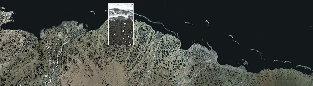
Figure 7. Trans-Alaska Construction Camps. The Trans-Alaska pipeline traverses vastly different types of terrain and environments across it’s 800-mile stretch. These are snapshots of the 20 construction camps used to house workers and equipment during its construction.
Scenario 1: Maximized Extraction
The first scenario envisions maximum extraction on the North Slope (Figure 11). In this scenario, offshore operations would proceed during the summer while avoiding the most critical ecological zones. The long winter gap in oil operation presents a potential to use the network of utilities and easements along the Trans-Alaska pipeline to employ workers and activate the pipeline infrastructure network all year. During off-peak hours workers deploy along the pipeline to camp sites and repair the infrastructure before building new Keystone oil and gas pipelines adjacent to the Trans-Alaska infrastructure, connecting the North Slope to the lower 48 states.
The Shell Oil company has previously agreed to invest 7 billion dollars into installing the infrastructure required to support the growth of the local oil industry [24]. Over the next 30 years the oil that flows through the pipeline would increase to approximately 40,000 BBO per year [25].
To ensure safe and efficient offshore operations a large port or series of ports would certainly be installed. The ports will house mobile oil vessels, transportation vehicles, deployable oil spill vehicles and other rescue-operation related vehicles. After peak oil and towards the end of the offshore oil boom, drilling platforms will start to become obsolete and abandoned; other onshore and offshore infrastructure will become unused and inefficient. If left uncared for, temporary housing built to support workers will become vacant and derelict. With no alternative industry available to support them, the construction camps from the oil boom would also turn into ghost towns.
There is significant pressure from climate activists to prevent unrestrained fossil fuel extraction. The ‘keep it in the ground movement’ has growing international momentum, and scientists argue that the extraction and burning of Arctic oil reserves is incompatible with preventing a 2 degree Celsius rise in global temperature [26], the ‘upper limit of present day natural variability’ that would mark a shift into a new extreme climate regime, with significant increases in heatwaves, sea level rise, and coral bleaching [27, 28]. This political pressure is making the prospect of an aggressive extraction strategy increasingly unlikely.
Figure 8. Scenario 1: Maximized Extraction in the North Slope. This is how future extraction could play out if fossil fuel extraction were given priority over other competing interests.
Scenario 2: Ecological Economy
An alternative scenario to the typical extraction process could involve the promotion of a diversified economy that would be seeded during this period of off-peak extraction, ultimately replacing crude oil as a mechanism of economic development. It positions easement rights of the future pipeline infrastructure as a bargaining chip to allocate resources for developing Alaska’s primary resource: immense and relatively untrammeled areas of natural beauty.
Tourism remains a large attractor and a significant part of the Alaskan economy. The tourism industry brings in around 850,000 visitors annually [29]. The expansion of Arctic drilling, if managed strategically, could help unlock a new tourism market. Today the tourism provides “over 36,000 direct and indirect jobs and accounts for 8 percent of Alaska’s employment” [30]. Currently Alaska has the United States second largest outdoor sporting industry. Primarily during the spring and summer months tourists come to hunt, fish, hike, bird watch, raft, ski, camp and dog sled in the wild (Figure 12). The Hana Shoal, an ecologically sensitive marine environment right at the heart of a major Alaskan offshore hydrocarbon site in the Chukchi Sea, is host to millions of organisms including snow crabs, clams and fish. Many large mammals also live off the northern coast of Alaska, including seals, walruses and many species of whales. Local residents can profit from tourism to areas like the Hanna Shoal while also bringing awareness of these ecological hotspots.
Beginning on the coast of the North Slope, alongside the future pipeline, new and previously dormant infrastructure can be cultivated to create a spine for recreation and production run by local and Native residents. Reestablishing the unused pipeline camps as tourism hubs can be a viable first step in encouraging economic growth and give additional agency to the ecologically sensitive sites such as the Arctic National Wildlife Refuge (ANWR). Tourism adjacent to ANWR would help protect crude oil extraction from mutilating the protected land and prevent habitat loss along the Arctic shoreline while bringing more awareness to the social and environmental concerns of Alaska’s fragile ecosystems. Some fossil fuel development is allowed, but rather than riding a boom-to-bust trajectory, it sets up a long-term non-extraction-based economy.
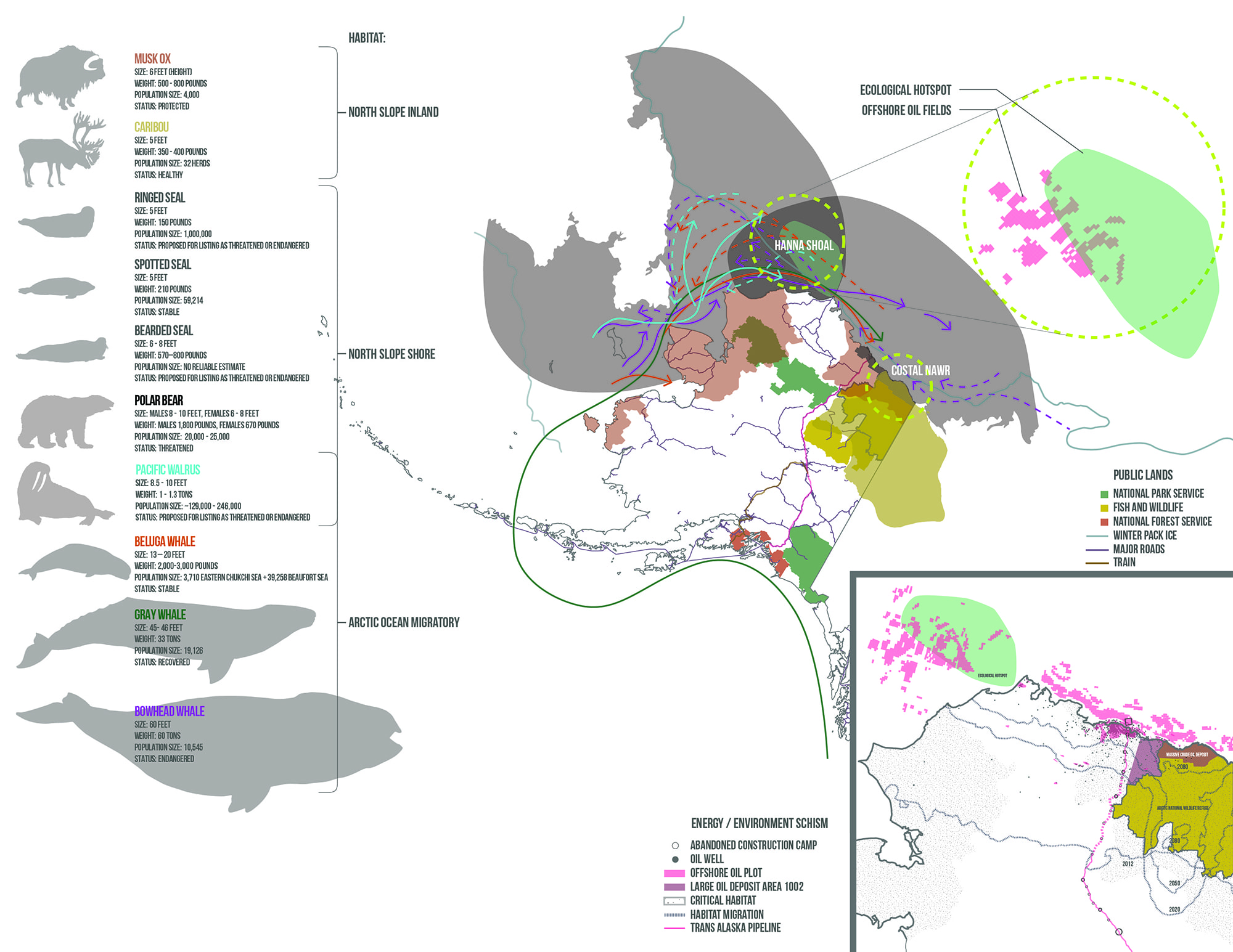
Figure 9. Scenario 2: Ecological Economy. The investigation explores using existing easements along the Trans-Alaska highway and pipeline to support the transient populations of both workers and tourists.
Scenario 3: Extreme Climate Change
A third scenario engages with the possibility of extreme climate change and its potential effects on the hydrocarbon extraction industry and related ecological impacts to this region. Because of the physical footprint necessary to support extraction infrastructure, encroachment on federal lands & protected areas, as well as the effects of climate change, habitat loss is inevitable both onshore and offshore. At the same time, as global warming continues to thaw the Arctic, previously inaccessible waterways become navigable, allowing oil to be transported to global markets more quickly and cheaply than is currently possible [31] (Figure 13). The Alaskan permafrost retreats hundreds of miles to the south by 2050 [32], with Alaska’s active layer continuing to defrost until permafrost ponds remain thawed year-round.
The Trans-Alaska pipeline armature incentivizes development through the provision of basic services such as water, electricity and transportation. A warming North Slope also means increased access to Alaska’s previously remote natural and ecological resources. All this, combined with the low cost of living here, leads to significant population increases. If climate change progresses as projections suggest, how will the state and local government respond to the pressure of rapid population growth?
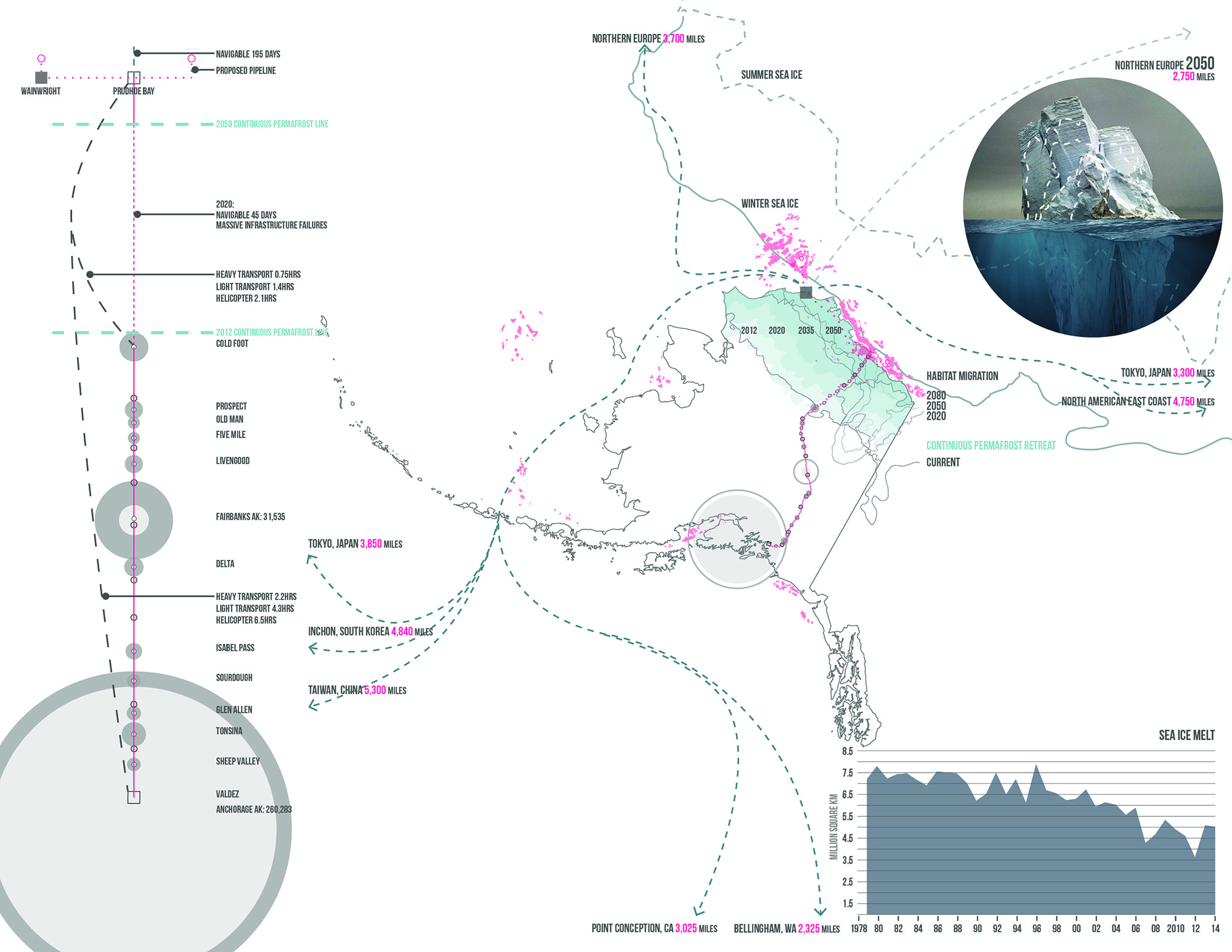
Figure 10. Scenario 3: Extreme Climate Change. This scenario looks at the potential future of the oil industry with extreme climate change. Recent science suggests these “extreme” scenarios are not actually that unlikely, and the Artic is changing faster than previously expected.
Diversifying Energy Infrastructure
To become resilient to a post-peak oil bust Alaska must respond to and employ elements of all three scenarios. If Alaska were to inject the vacant base camps along the Trans-Alaska pipeline with programs that supports the present-day oil industry, while building infrastructure in the offseason for future renewable energy sources and the underserved ecological tourism economy, the latter could emerge to succeed oil industry in economic support. Coupling the single-use infrastructure of the pipeline with alternative program and future clean energy provides the bones for establishing an economy that will live alongside the infrastructure footprint and diversify the local economy. These underlying systems can become the agents for an ecotourism network that has the potential to provide support and stabilize Alaska’s post peak oil economy.
Alaska will require more support that what ecotourism alone can contribute to the welfare of the state. Alaska has vast renewable energy resources that, if harnessed, have the potential to supersede the hydrocarbon industry. Because of the limited offshore extraction season the workers can operate for half of the year. During this other half of the year the oil workers can find employment supporting the alternative energy industries south of the North Slope where daylight and temperatures provide an opportunity for work (Figure 14). Coupling the hydrocarbon energy infrastructure with renewable energy resources will ensure that future energy and the state’s economic demands are satisfied after peak oil.

Figure 11. A Sustainable Scenario. This is an investigation of how the multiple use mandate on federal lands can aid in providing a sustainable future for Alaska.
The largest state in the United States, Alaska, has the third smallest population while using the third most energy. This can largely be attributed to the high energy use in harsh winters and the state’s energy-intensive industries [33]. Like the rest of the world, today Alaska primarily relies on fossil fuels for its energy needs even though the state has enough renewable energy resources available to displace the state’s current fossil fuel consumption volume [34] (Figure 15). Solar, biomass and wind energy sources possess the most potential for renewable energy production here. Because of the state’s large land area and small population, the potential for large-scale renewables is enormous.
61% of Alaska’s 364.5 million acres are federal public lands, with a mandate that enables extraction of resources for public benefit. Alaska’s public lands carry the potential to produce over 9,000,000 GHw of renewable energy [35]. This is enough clean energy to supply power for the state’s entire energy expenditure.

Figure 12. Alaska’s Renewable Energy Potential. The state of Alaska has a very high energy demand despite having a low population. The majority of these demands are met with fossil fuel consumption; however, the renewable energy potential here is enough to satisfy the state’s energy use.
Reimagining the Camp
Fairbanks is the 8th camp along the pipeline from the southernmost point. This camp, like the other 20, is currently abandoned but has utility hookups and basic infrastructures. The Fairbanks site is located near a large town and surrounded by Bureau of Land Management and Fish and Wildlife lands. Within these adjacent federal lands there is a large potential for solar and biomass energy production. To prepare this site for renewable operations construction can begin by building a transformation station to tie the future solar farm and other future energy sources into the U.S. electrical grid. In addition to the creation of solar fields, the clearing and seeding for a biomass farm will provide the resources for future renewable extraction at Fairbanks. Simultaneous with the construction of the energy hubs all 20 Trans-Alaskan pipeline camps could be renovated to accommodate regional tourism. Each construction camp can act as a nucleus, serving as the base for local activities and/or renewable energy production. By 2050 when the offshore oil resources begin to dry up the renewable energy systems can be fully operable and deeply embedded in local ecotourism operations. Around the main Fairbanks Camp several camp clusters can be installed to extend the tourism network laterally into the public lands.
The Coldfoot Camp is 200 miles North of Fairbanks and is positioned at the intersection of fertile ground and the present-day continuous permafrost zone. This is a strategic location for the Trans-Alaska operations because beyond this node Dalton Highway, the supply road for the pipeline system, becomes dangerous – especially during the winter months. The existing airfield here serves as a temporary base and transports supplies to Deadhorse, the terminus of the infrastructure at the Arctic Ocean. When offshore oil operations begin the State can take advantage of the high onshore wind potentials around Coldfoot. Building out the wind farm will take several years to complete; Both, during and after the installation of the turbines the pathways created to construct the renewable energy machines can be utilized as routes for tourists looking to hike, bike, hunt and explore the Alaskan wilderness. The trails created for the turbines, typically along the ridges of Brooks Range, can also host satellite camps for tourists.
Prudhoe Bay is the last stop along the Trans-Alaska infrastructure terminating at the shore of the North Slope. At this location where the North Slope meets the Arctic Ocean. In the coming years the offshore hydrocarbon extraction is expected to begin off the coast of the North Slope near the Hanna Shoal. Establishing access for tourism here will help protect the most sensitive ecological zones by providing advocacy through exposure. After the hydrocarbon industry’s operations recede, parallel with the continuous Arctic ice melt, tourism operations can expand by taking advantage of the increased water navigability during peak tourist season and the increased availability of the hydrocarbon operations infrastructure. Wind farms can begin to occupy the territories in the high wind zones off the coast and tie-in to the electrical grid. Between the permafrost ponds near the shores of the Beaufort Sea architectural structures can be installed to serve as basecamps for recreational activities. Temporary worker housing installed to house the seasonal workers of the oil industry can be repurposed for use by tourism operations.
![]()
Figure 13. Alaska Oil Migration/ Old Dormant Trans-Alaska Pipeline Construction Camps. The widely abandoned camps have existing resources such as airplane runways, shelters, power and water.
Critically evaluating Alaska’s future potential before construction begins on the Keystone Pipeline and leases are given in the offshore oil fields is paramount for creating a sustainable future for the state. This provocation — converting the future of the pipeline’s infrastructure from a single-use infrastructure into an armature that intertwines service and extraction with recreation and access, is an attempt to deliver more than a good-natured design proposal; it is a vast, high-impact design strategy for a resilient future. This goal will be achieved by introducing renewable practices that will be built to supersede the archaic energy methods of the fossil era and enables the construction of new landscapes that services both the public and private industry. In this way the capital interests can be satisfied but also leveraged to serve the needs of the public (Figure 16). Over the next 40 years as the oil industry moves beyond peak extraction, biomass, solar, onshore and offshore wind energy development can grow to a level that can sustain Alaska’s population growth and contribute to the energy grid of the lower 48 states.
![]()
Figure 14. A New Trans-Alaskan Armature. This provocation proposes adding a few strategic resources to the existing camps which take advantage of the adjacent federal lands and their natural resources. Key construction camps would double as renewable energy hubs providing jobs and the foundation for a sustainable future.
 Michael W. Smith is a senior landscape architect at Landscape Architecture Bureau in Washington, D.C. where he has overseen several projects including the DHS Access Road Ecotones research and infrastructure project, the LeDroit Park Green Infrastructure Project, Marvin Gaye Trail, Phase I of the District Wharf, and Ingleside at Rock Creek’s community campus redevelopment. Michael’s work uses the built environment as a laboratory to investigate infrastructure networks and their relationships to the contemporary surrounding environment. Outside of professional practice Michael works on landscape research projects that aim to develop a better understanding of the benefits of landscape architecture at the local and regional scales. The threads of Michael’s professional work and research can be summarized as the systematic deconstruction of infrastructure lines and urban systems to evaluate, understand and improve them while developing strategies which support habitat and benefit the surrounding communities. This fall, he is instructing a design studio at Virginia Tech’s Washington-Alexandria Architecture Center.
References
[1] Serkine, Pierre. Peak Oil: Assessment, Critique of the Current Solutions, and Proposition of Alternatives. Bruges: College of Europe, 2013.
[2] Campbell, C. J. Oil Depletion –The Heart of the Matter,” prepared for The association for the Study of Peak Oil and Gas by Rocky Mountain Institute, Reinventing Fire, Chelsea Green. http://www.energycrisis.com/campbell/TheHeartOfTheMatter.pdf
[3] Smith, Grant. “IEA predicts global oil demand will level off around 2030.” World Oil. November 13, 2019. https://www.worldoil.com/news/2019/11/13/iea-predicts-global-oil-demand-will-level-off-around-2030.
[4] U.S. Energy Information Administration. “Review of Emerging Resources: U.S. Shale Gas and Shale Oil Plays.” Washington D.C.: U.S. Energy Information Administration, July 2011. https://www.eia.gov/analysis/studies/usshalegas/pdf/usshaleplays.pdf
[5] U.S. Energy Information Administration. “Lower 48 States Crude Oil Proved Reserves (Million Barrels).” Washington D.C.: U.S. Energy Information Administration, December 2019. https://www.eia.gov/dnav/pet/hist/LeafHandler.ashx?n=PET&s=RCRR01R48_1&f=A
[6] “The American Association of Petroleum Geologists.” Science 5, no. 1 (1921): 12. doi:10.1126/science.59.1514.12-a.
[7] Chauhan, M. S. Horizontal Drilling Engineering: Theory, Methods and Applications. Valley Cottage, NY: Scitus Academics, 2016.
[8] U.S. Bureau of Ocean Energy Management. “Assessment of Undiscovered Oil and Gas Resources of the Nation’s Outer Continental Shelf, 2016.” https://www.boem.gov/2016-National-Assessment-Fact-Sheet/
[9] “Why Shell Is Betting Billions to Drill for Oil in Alaska.” Fortune. Accessed April 21, 2019. http://fortune.com/2012/05/24/why-shell-is-betting-billions-to-drill-for-oil-in-alaska/.
[10] National Geographic Society. “Petroleum.” National Geographic Society. January 14, 2013. https://www.nationalgeographic.org/encyclopedia/petroleum/.
[11] Bird, Kenneth J. et al. “Circum-Arctic Resource Appraisal: Estimates of Undiscovered Oil and Gas North of the Arctic Circle.” United States Geological Survey, Fact Sheet 2008-3049. July 2008. http://pubs.usgs.gov/fs/2008/3049/fs2008-3049.pdf
[12] Ibid.
[13] Freking, Kevin. “Obama Administration Approves Arctic Drilling Ahead of President’s Visit to Alaska.” PBS. August 18, 2015. https://www.pbs.org/newshour/nation/approval-arctic-drilling-comes-just-obamas-visit.
[14] The Alaska Department of Labor and Workforce Development. “Gasline Workforce Plan.” International Energy Statistics. http://jobs.alaska.gov/energy/2018_Gasline_Workforce_Plan.pdf
[15] Alaska Department of Labor and Workforce Development, Research and Analysis Section. “Components of Population Change for Alaska, 1947-2019.” http://live.laborstats.alaska.gov/pop/estimates/data/ComponentsOfChangeGraph.pdf
[16] U.S. Energy Information Administration, Annual Crude oil Production, 42nd Series. April 30, 2019. http://www.eia.gov/dnav/pet/pet_crd_crpdn_adc_mbbl_a.htm
[17] Alaska Department of Revenue- Tax Division. “Fall 2018 Sources Revenue Book.”
[18] Fuchs, Walter. When the Oil Wells Run Dry. Dover, NH: Industrial Research Service, 1946.
[19] Joling, Dan. “Arctic Offshore Production Wells Approved off Alaska’s Coast.” AP NEWS. Associated Press, October 24, 2018. https://apnews.com/73e0b2c8f8854c5482f34af9f889b3dc.
[20] Alaska Department of Labor and Workforce Development, Alaska Population by Economic Region, Borough and Census Area: 2010 to 2035. April 16, 2012. http://labor.alaska.gov/news/2012/news12-26.pdf
[21] Avery, Samuel. The Pipeline and the Paradigm: Keystone XL, Tar Sands, and the Battle to Defuse the Carbon Bomb. Washington, DC: Ruka Press, 2013.
[22] Ibid.
[23] Ibid.
[24] Gilbert, Daniel and Sarah Kent. “Shell Places Huge Bet on Arctic Oil Riches,” The Wall Street Journal, July 7, 2015. https://www.wsj.com/articles/shell-places-huge-bet-on-arctic-oil-riches-1436311938
[25] King Economics Group, Alaska North Slope 10-Year Oil Production Forecast. November 19, 2018. https://kingeconomicsgroup.com/alaska-north-slope-10-year-oil-production-forecast/
[26] Mcglade, Christophe and Paul Ekins. “The Geographical Distribution of Fossil Fuels Unused When Limiting Global Warming to 2 °C.” Nature517, no. 7533 (January 8, 2015): 187–90. https://doi.org/10.1038/nature14016.
[27] “IPCC Special Report on the Impacts of Global Warming of 1.5 °C.” IPCC special report on the impacts of global warming of 1.5 °C. IPCC Bureau, October 5, 2018. https://www.ipcc.ch/sr15/.
[28] Schleussner, Carl-Friedrich et al. “Differential Climate Impacts for Policy-Relevant Limits to Global Warming: the Case of 1.5°and 2° C.” Earth System Dynamics 7, no. 2 (April 21, 2016): 327–51. https://doi.org/10.5194/esd-7-327-2016.
[29] Blazar, John. ‘Before Losing Yourself in the Vastness of Alaska, Be Prepared for Crowds : Wonders are there to enjoy, but the season is brief. To see the most, relax and rush less.” Los Angeles Times. July 7, 2015. https://www.latimes.com/archives/la-xpm-1992-06-14-tr-617-story.html
[30] Resource Development Council for Alaska, Inc. “Growing Alaska through responsible resource development.” 2011. https://www.akrdc.org/assets/docs/annualreport2011.pdf
[31] Wilson Center. “Opportunities and Challenges for Arctic Oil and Gas Development.” https://www.wilsoncenter.org/sites/default/files/Artic%20Report_F2.pdf
[32] Climate Change Impacts on the United States: Foundation Report. Cambridge: Cambridge University Press, 2001.
[33] U.S. Energy Information Administration. “Alaska State Profile and Energy Estimates.” November 15, 2018. https://www.eia.gov/state/?sid=AK
[34] National Renewable Energy Laboratory. “Renewable Energy in Alaska.” https://www.nrel.gov/docs/fy13osti/47176.pdf
[35] Ibid.
Infographic Sources
Figure 1. World Oil Discoveries
Data Source: Campbell,C.J.. ‘Oil Depletion – The Heart of the Matter.” The association for the Study of Peak Oil and Gas; Rocky Mountain Institute, Reinventing Fire, Chelsea Green.
Association for the Study of Peak Oil and Gas, “Peak Oil.”
Energy Information Administration, ‘U.S. Field Production of Crude Oil.”
The MacroStrategy Partnership LLP, “Absolute Return Oil Price.”
Figure 2. U.S. Crude Oil Field Production & Oil Rig Deployment
Data Source: Energy Information Administration, “U.S. Field Production of Crude Oil.”
Energy Information Administration. “U.S. Crude Oil and Natural Gas Rotary Rigs in Operation.”
Figure 3. North American Fossil Fuel Atlas
Energy Information Administration, “Layer Information for Interactive State Maps.” Energy Disruptions, Major Oil and Gas Plays, U.S. Energy mapping System. Using: ArcGIS [GIS software].
Energy Information Administration, “Low permeability oil and gas play boundaries in Lower 48 States.” 3/11/2016. Using: ArcGIS [GIS software].
Energy Information Administration, “Sedimentary basin boundaries in Lower 48 States.” March 11, 2016. Using: ArcGIS [GIS software].
Energy Information Administration, “Marcellus play boundaries, structure and isopachs.” March 11, 2016. Using: ArcGIS [GIS software].
Energy Information Administration, “Permian Basin: boundary, structure and tectonic features.” December 21, 2019. Using: ArcGIS [GIS software].
Energy Information Administration, “Niobrara play boundaries, structure and isopachs.” March 11, 2016. Using: ArcGIS [GIS software].
Energy Information Administration, “Eagle Ford play boundaries, structure and isopachs.” March 11, 2016. Using: ArcGIS [GIS software].
Energy Information Administration, “Bakken and Three Forks play boundaries, structure and isopachs.” March 11, 2016.
Energy Information Administration, “field boundaries (2007), resources (2006), reserves and production (2006), and top 100 methane emitting coal mines (2005). Using: ArcGIS [GIS software].
Figure 4. The Race for Arctic Hydrocarbons
U.S. Geological Survey, Central Energy Resource Team, “Map Service Showing Geology, Oil and Gas Fields, and Geologic Provinces of the Arctic. 2009. Using: ArcGIS [GIS software].
Figure 5. Crude Oil & Coal Deposits in the U.S. Arctic Territory
Energy Information Administration, “field boundaries (2007), resources (2006), reserves and production (2006), and top 100 methane emitting coal mines (2005). Using: ArcGIS [GIS software].
U.S. Geological Survey, Central Energy Resource Team, “Map Service Showing Geology, Oil and Gas Fields, and Geologic Provinces of the Arctic. 2009. Using: ArcGIS [GIS software].
Figure 6. Alaska Oil Migration/ Future Offshore Oil Boom
Energy Information Administration, Alaska Field Production of Crude Oil; Alaska Department of Labor and Workforce Development, Research and Analysis Section, Components of Population Change for Alaska, 1947-2013.
Figure 7. Trans-Alaska Construction Camps
Google Earth, Trans Alaska Pipeline. Accessed March 1, 2014.
Figure 8. Scenario 1: North Slope Maximized Extraction
Energy Information Administration, Alaska Field Oil Production of Crude Oil. Using: ArcGIS [GIS software].
Figure 9. Scenario 2: Ecological Economy
Federal Lands of the United States. June 2005. Using: ArcGIS [GIS software].
Figure 10. Scenario 3: Extreme Climate Change
United States Geological Survey, Genetic and Climate Models; Trish McAlaster, The Globe and Mail, Pewtrusts.org.
Figure 11. A Sustainable Scenario
Federal Lands of the United States. June 2005. Using: ArcGIS [GIS software].
Figure 12. Alaska’s Renewable Energy Potential
Energy Information Administration, Rankings: Total Energy Consumed per Capita; Census Bureau, 2010 Census.
National Renewable Energy Laboratory. Geospatial Data Science. Data Resources. Biomass, Geothermal, Hydrogen, Marine and Hydrokinetic, Solar and Wind Data. Using: ArcGIS [GIS software].
Figure 13. Alaska Oil Migration/ Old Dormant Trans-Alaska Pipeline Construction Camps.
Google Earth, Trans Alaska Pipeline. Accessed March 1, 2014.
Figure 14. A New Trans-Alaskan Armature
Google Earth, Trans Alaska Pipeline. Accessed March 1, 2014.
Cite
Michael W. Smith, “Territory of Extraction: The Crude North,” Scenario Journal 07: Power, December 2019, https://scenariojournal.com/article/crude-north/.