Introduction: Indeterminacy & Multiplicity

Indeterminacy and Multiplicity

What is landscape urbanism? What do we envision—we, who design in cities, who create landscapes, and who imagine the possibilities and potential of future urban environments? What do you want to see and do—you, who work and live in cities and the surrounding regions? What are our goals and objectives, and do they cohere, conflict, or cohabitate?

Are landscape urbanists intentionally avoiding concrete answers, side-stepping specifications and detailing because we cannot articulate or formulate our visions—be they broad regional plans or at the fine-grained materiality of a specific site? Are we charismatic chimeras who spin tales and pretty pictures that evaporate at the first sign of hammers and nails, contracts, and bluebooks?

We are doing something different. We are in uncharted territory because we are spinning new narratives. We are taking on new responsibilities, and we are approaching challenges with faceted lenses, recognizing and incorporating—with sense and sensibilities—the vast variety of interests, concerns, investments, and collisions that are the landscape of cities.

In 2011, the making of the first version of this website—landscapeurbanism.com—was a kind of SimCity game with all the anticipatory glee, hope, and stumbles. On top of the pins and needles of constructing the site itself—acquiring and editing content, marketing and outreach—whole sections of the site were scrapped and months later re-introduced; endless iterations of workflow management were posted and trashed; and hours were spent pondering puzzles and formulating systematic answers in memos and diagrams—e.g., is landscape urbanism capitalized? Caveats aside, we say no. Why? We err in the belief that landscape urbanism is a study, with parameters, but not an ideology. One conundrum among many.

 Photo by Kevin Saavedra

Working with the many writers, designers, practitioners, editors, advisors, and investors, without whom the site would have been never realized, was an incredible and gratifying experience. With every decision and detail looming large, threatening or hearkening some unknown, this site became, and still is, a work in progress with more to come.

In this issue, we examine landscape urbanism’s origins and future potential; its coherences and incoherencies; and working definitions that hold the seemingly conflicting factors of space, time, indeterminacy, and multiplicity. We have tried to create a resource and tool for the designer, for the city dweller, for the scholar, and for the curious. In doing so, we hope to stimulate your mind, delight your senses, offer reference and inspiration, and provide a platform for thoughtful discussion.

Inside this issue, you’ll find Christopher Gray and Shanti Levy illuminating the antecedents and legacies of landscape urbanism, while Gerdo Aquino calls for more built works to bolster its role. We also join as Laura Tepper scurries across Dutch highways wondering what happened to a West 8 installation. In light of the remarkable software developments now taught and applied in our field, Andrea Hansen pulls together the evolution of computational representation techniques and how these digital tools imprint form on land. Lauren Manning, a visual information designer, looks at four tools for data representation in her analysis of diagrammatic, infographic, mapping, and narrative forms of visual storytelling. And finally, despite all of the digital technology at our fingertips, we return to the act of a few people gathering to talk, in person or over the phone. Meg Studer sits with Charles Waldheim to collect his thoughts on landscape, ecological, and infrastructural urbanisms with regard to recent global events; and we are re-issuing an essay by Waldheim asserting the need, despite the current proliferation of urbanism modifiers, for a progressive, ecologically informed urban practice.

Cities are intricate places, built in mish-mashed layers. Similarly, conversations collide and overlap—a jumble of ideas that obscure or emerge with every exchange. We are not singularly focused or unidirectional in our modes of design, nor have we settled on one tool of communication. Every project and conversation—each iteration—offers a lens to view, describe, or alter our work and world.  This first collection of essays looks both at what we mean when we use the words “landscape urbanism,” at how we tell the stories of landscape urbanism, and in the telling, how we can continue building.

For the editors, the past few years has been a unique privilege synthesizing and coordinating a rush of ideas, feedback, enthusiasm, and efforts from many talented people and remarkable firms, publications, and organizations. Our worlds have cracked open through all those we have met and who have entered into conversation with us. We are so grateful. And we hope that your world is opened too. We welcome your comments. Please, join us, and let us know what you think.


Visitors looking for the first two volumes of Landscape Urbanism can find the original articles in the archive pages.


Sarah PeckSarah Kathleen Peck is a writer, designer, and storyteller. In 2011, she created the LandscapeUrbanism.com website and served as the co-editor of landscape urbanism journal issues 01 and 02 and the editor of the website. Her work lies in the spaces between environments, technology, communications, and strategy. She grew up in Palo Alto, and graduated with a BA in Psychology from Denison University and an MLA from Penn Design. She currently writes and teaches storytelling workshops across the country. 

Eliza Shaw Valk served as co-editor of LandscapeUrbanism.com from 2011-2013 and was co-editor of landscape urbanism journal issues 01 and 02. As a landscape architect and artist based in New Haven, Connecticut, she works to integrate ecological processes, resource management, and socio-economic needs into the design of resilient, accessible, and adaptable land use systems. She grew up in New York City and Kansas, and graduated from Oberlin in art. Eliza holds master’s degrees in landscape architecture and city planning from the University of Pennsylvania.


Landscape Urbanism: Definitions & Trajectory

Landscape urbanism emerges

Perhaps the time has come to state, definitively, that landscape urbanism has in fact emerged. Described for so long as an “emerging” practice, landscape urbanism—with all of its ambiguity and complexity—represents a significant twenty-first century design and planning ethos. Several prominent universities promote and support its principles, design firms include it in their firm names, and the term has even begun to enter national media and press,  (note 1) in fields outside its usual currency.

While its landscape urbanism’s raised profile is undeniable, an actual definition or common methodology remains elusive. Even describing landscape urbanism as a practice is at times regarded as a stretch, while it is commonly characterized as an approach, study, or way of thinking about the contemporary city. (note 2) Furthermore, built examples of landscape urbanism are still rare, if only because projects set to test its principles are still under construction.

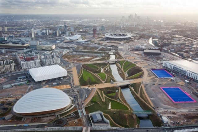
Aerial view of the London Olympic Parklands. Image from London 2012.

Yet the predominant use of landscape as a restructuring process, in parallel with infrastructure and ecology, is evident in a slew of prestigious recent works, from the heavily remediated site of the London 2012 Olympics (note 3) with its sensitivity to existing watercourses, to Brooklyn Bridge Park’s careful accommodation of storm events and tidal flows in an urban space. (note 4) While the attention given to landscape urbanism may be a response to a confluence of factors—an uncertain or stagnant economy, a pressing need to re-evaluate our environmental policies and aging infrastructure, and a growing interest in the visibility of ecological processes and design—it suggests that we are beginning to tolerate and even embrace the ideas of uncertainty, process, and design complexity in already intractable and attenuated urban settings.

Definitions

Landscape urbanism appears to offer a way to consider the complex urban condition; one that is capable of tackling infrastructure, water management, biodiversity, and human activity; and one that asks and examines the implications of the city in the landscape and landscape in the city. (note 5) This framework and scholarship ranges from straightforward to abstract research, but generally stems from a sense that landscape can be used as a model and basis for urban initiatives, and a lens through which to examine our cities. (note 6) On that basis, more esoteric and theoretical theories hang—such as the concern for the field over the object and the move to consider the operative (i.e., the processes of nature and culture) over purely representational or static landscape. The changing relationship between the contemporary city and the territory within which it sits has shaped these perspectives: boundaries between city and country are dissolving, forming a homogeneous continuum that has inspired the recent influx of “insert-adjective-here urbanism,” with no one method yet prevailing.

These multiple perspectives and hybrid “-isms” have evolved from this shared critical context; some may be considered parallel practices to landscape urbanism, while some are quite different. Infrastructural urbanism (note 7), for instance, shares a concern for flexible ordering principles to accommodate yet unknown future activities, but promotes the creation of artificial ecologies rather than integrating existing environmental conditions. Mat urbanism (note 8 ) and Foreign Office Architect’s phylogenesis (note 9) suggest that underlying forces in the landscape can be abstracted and made manifest, to create “thick” surfaces and hybrid building forms that may be interpreted as both building and landscape. Ecological urbanism suggests that design is the key to balancing the conflicts between ecology (uninfluenced by humans) and the overt consumption of urbanism.

While these terms share a common background and theoretical foundation, they appear formulated to address very specific concerns rather than serve as an approach for multiple and diverse landscape issues which underpin the contemporary city. Landscape in these terms appears as a burden to be solved by mechanisms, rather than a complex and essential part of these dense areas we call cities, a fundamental which needs to be sifted and nurtured.

Retrieving special meaning

Part of the strength and depth of landscape urbanism comes from the use of two words that previously might be held in opposition, suggesting a hybrid discipline. As landscape urbanism is not a neologism or amalgam—such as landurbanism or urbanlandscapism—the compound term carries the respective complexities and critical baggage of each word. Powerful subtleties in interpretation of both words have been recovered over the past decade to strengthen and augment them; what distinguishes landscape urbanism from parallel practices is the nuanced meaning of the word landscape. Its rich etymology has been written about extensively the earliest Dutch usage to describe a picture representing scenery has evolved into a term in which human influence (even if it is simply the act of viewing) is key. Landscape literally describes the state of altered land, as distinct from virgin land before human influence: “all landscapes are constructed … they are phenomena of nature and products of culture.” (note 12) Landscape in this definition is very much about the representational, the pictorial and (at least historically) the painted.

“In pairing landscape with urbanism, landscape urbanism seeks to reintroduce critical connections with natural and hidden systems and proposes the use of such systems as a flexible approach to the current concerns and problems of the urban condition.”

Cosgrove (note 13) and Corner, amongst others (note 14), have sought to reintroduce contemporary landscape associations: with scale beyond visual limits, with depth below the surface and with processes across the field. Recovering meanings from the German landschaft (note 15) and territory (note 16) acknowledges human impacts on land, a crucial and contemporary move from object to active field and recognizes that “[landscape] is organized by a multiplicity of forces without obvious formal unity.” (note 17) This final distinction is critical: the importance of deep, even invisible, rules which govern the fields that they describe, defines more readily the potential of landscape urbanism practice. It is the creative and poetic opportunity of these hidden forces that Corner proposes as a unique theme of landscape urbanism practice: where “earlier urban design and regionally scaled enterprises [failed] was [in] the oversimplification, the reduction, of the phenomenal richness of physical life.” (note 18)

Dynamic Systems, materiality and program: Image and project by MVVA

Specific practices

The compound term landscape urbanism offers a way to regain references to people, place and nature within the design field and urban context. In pairing landscape with urbanism, landscape urbanism reintroduces critical connections with natural and hidden systems and proposes the use of such systems as a flexible approach to the current concerns and problems of urban conditions. This flexibility has allowed landscape urbanism to resolve into different perspectives, the two most distinct modes of which can be described as the machine landscape mode as defined by Mohsen Mostafavi and the field operations mode as set out by James Corner.

As directed in The Machinic Landscape and the Landscape Urbanism course of the Architectural Association (note 19), the machinic landscape mode undertakes a very specific survey and analysis of the site to identify underlying forces. These are then fed into an abstract mechanism (usually a form of computer algorithm) that creates architectural forms, often of large scale and organic geometry. Often, those outside the profession grasp this particular perspective of landscape urbanism because the end result is a recognizable architectural form, albeit an abstract one.

Alternatively, the field operation mode seeks a less determined end product. Its design and construction utilizes complex and intertwined “soft” natural systems based on ecological communities and hydrological patterns. A fixed outcome is rarely envisaged at the outset, but the potential scenarios for the site are forecast to explore the multiple processes at play across the wider area. The ultimate aim is an active landscape that repairs and improves what are frequently ravaged natural systems, but with an eye to drawing out meaningful and often poetic landscape elements.

“The landscape urbanist’s long-term view and mode of careful analysis is perfectly suited to the retrieval and manifestation of a site’s meaning, feeding into a design process which starts the course of growing a real and authentic landscape response.”

Why is it critical now?

So why has landscape urbanism appeared to grow so strongly over the past decade, and why is it critical now? A number of reasons are apparent, relating to economy, collaboration, and authentic design.

Economy. In light of the recent economic downturn, traditional economics of construction are severely challenged, resulting in numerous stalled developments within and on the edges of cities. They range in scale from gap sites to district-size wastelands, and are weighed down by debt and unrealizable value—their function and usefulness appear lost.

In Edinburgh, Scotland, plans to transform post-industrial waterfront land into high-density neighborhoods have foundered: the sites repossessed by banks from bankrupt developers and left to quietly recover. These are places which appear quite different from the ideas of the polished and different “new towns” of the post-war period, yet are critical to the future evolution and consolidation of the city. If it is no longer economically viable to create new cities and towns, nor feasible to abandon cities with shrinking densities, what, then, is to be done with these stalled sites?

Reflecting a scenario all over Europe, these stalled sites are actually located in the heart of culturally dense and landscape rich areas and are a vivid and graphic expression for those living around them of the changing nature of our cities. These are the types of places where landscape urbanism should be engaged, reclaiming and restructuring the landscape cannily and efficiently in advance of financial recovery. Where building and development is not economically viable, landscape urbanism in the interim is a valid proposition. The landscape urbanist’s long-term view and careful analyses are perfectly suited to the retrieval and manifestation of a site’s meaning, feeding into a design process which starts the course of growing a real and authentic landscape response.

Collaboration across disciplines and communities. The ever-increasing pressure on other, natural, forms of resource also dictates a change in the way we think about urbanism and buildings. A renewed environmental responsibility has arisen, but we must translate these into significantly different approaches within the traditionally conservative construction and development sector. The current inability or unwillingness to consider the impact of unconfined development on natural processes must be challenged; better engagement on these issues across disciplines and across communities will be critical. The past era of nonchalance with regard to the environment is returning to haunt us, with the impacts increasingly becoming visible. Construction on floodplains, escalating surface runoff due to increased impermeable surfaces, and an increasingly homogeneity of amenity plantings cumulatively impact our city’s hydrological systems, ecological habitats, and our ability to identify and associate with natural elements in our built environment.

Landscape urbanism offers an approach which draws from multiple disciplines to promote a forum in which these consequences are understood and avoided. This collaboration extends into the communities that are directly affected, through visual education highlighting the positive impact of design. Efforts such as de-culverting a poorly constructed urban waterway or improving the biodiversity of our public open spaces through habitat enhancement make these innovations explicit. Instead of the automatic adoption of technical “solutions” or ineffective policies that hide impacts, landscape becomes the “modern glue that holds the modern metropolis together.” (note 20)

Drawing out the invisible. Beyond the prosaic and constructive side of landscape urbanism—and perhaps the strongest rationale for its longevity— there is the imaginative and poetic side to landscape: the ability to tease out invisible systems and make them part of our consciousness .

As design professionals practicing in the twenty-first century, we must reduce the energy demands of our designs, increase efficiencies, and integrate renewable energy. But beyond these planet-saving technical measures, we must ensure that new and revived urban areas are still places that g celebrate the intrinsic qualities of a site: landscape urbanism has the potential to bring out the hidden, the unknown and the delightful for those who inhabit these places. These abilities and processes will make landscape urbanism an ethos that appeals to professionals and people beyond the field.

Conclusion

For an ethos that celebrates uncertainty, underlying complex processes, and the grey areas of contemporary urban conditions, a clear definition is difficult to distill into a fixed statement. Regardless of the shades of meaning or abstraction adopted, landscape urbanism tries to understand the massive complexity of the world that we live in, to work collaboratively with other disciplines to produce solutions that are respectful to sites and inhabitants, and also create new urban spaces that contribute to the wider natural and cultural territory. In its unique potential to take a poetic gauge of environmental processes, landscape urbanism differs from other practices. The ability to recognize, embrace and transform such subtle but powerful forces suggests a way to design authentic, yet newly imagined places that immerse us in the richness of landscape.


Chris Gray is an architect and landscape architect who works at the boundary between the two disciplines. His professional experience ranges from complex urban projects with tightly integrated architectural interventions to large scale development frameworks and masterplans. Chris has a strong interest in contemporary landscape design, the development of the modern city and authentic design within sensitive landscapes.


Note 1: Leon Neyfakh. “Green Building,” Boston Globe. 30th January 2011.
Note 2: James Corner. “Landscape Urbanism,” in Landscape urbanism: a manual for the machinic landscape, eds. Mohsen Mostafavi and Ciro Najle. (London: Architectural Association, 2003) 58.
Note 3: [Illustration: The waterways around the industrial area where the Olympic Park is situated were among the most polluted in London (and the UK) and an approach was taken to remediate the whole area based on their treatment.]
Note 4: [See second illustration, next page: An excellent image of the park which shows dynamic systems, programme and materiality at play together by MVVA]
Note 5: James Corner. “Terra Fluxus” in The Landscape Urbanism Reader, ed. Charles Waldheim. (New York: Princeton Architectural Press, June 2006) 25.
Note 6: Stan Allen. “Mat Urbanism: The Thick 2-D” in CASE: Le Corbusier’s Venice Hospital and the mat building revival, ed. Hashim Sarkis. (Munich; New York : Prestel, 2002.) 124.
Note 7: Stan Allen. “Infrastructural Urbanism” in Points + lines : diagrams and projects for the city, ed. Stan Allen. (New York : Princeton Architectural Press, 1999).
Note 8: Alison Smithson. “How to recognise and read mat-building” in Architectural design 44, 9, 1974. 573-590, reprinted in CASE: Le Corbusier’s Venice Hospital and the mat building revival, ed. Hashim Sarkis. (Munich; New York: Prestel) 2002.
Note 9: Foreign Office Architects. Phylogenesis: foa’s ark. Actar. March 2004, 11.
Note 10: Mohsen Mostafavi and Gareth Doherty. Ecological Urbanism. (Baden, Switzerland: Lars Müller Pub. 2010)
Note 11: See James Corner, ed. Recovering landscape: essays in contemporary landscape architecture. (New York : Princeton Architectural Press, 1999) for a collection of essays that supply various definitions of landscape beyond the representational.
Note 12: Anne Winston Spirn. “Constructing Nature: The Legacy of Frederick Law Olmsted,” in Uncommon Ground: Rethinking the Human Place in Nature, ed. by William Cronon. (New York; London:W.W. Norton & Company, 1996) 113.
Note 13: Denis E. Cosgrove. Social Formation and Symbolic Landscape. (Kent: Croom Helm, 1984) 13.
Note 14: Sanford Kwinter. “American Design?” in Praxis: journal of writing + building, no. 4, (2002) 6.
Note 15: James Corner. “Eidetic Operations and New Landscapes” in Recovering landscape: essays in contemporary landscape architecture, ed. by James Corner. (New York: Princeton Architectural Press, 1999) 154.
Note 16: Sanford Kwinter. “American Design?” in Praxis: journal of writing + building, no. 4, 2002.
Note 17: Ibid., 6.
Note 18: James Corner. “Terra Fluxus,” 32.
Note 19: Mohsen Mostafavi and Ciro Najle, eds. Landscape urbanism: a manual for the machinic landscape. (London: Architectural Association, 2003)
Note 20: Alex Krieger. “Territories of Urban Design.” in Territories of Urban Design. GSD, Harvard, Feb. 2004. Web. 13 Aug. 2011.

The Re-Representation Of Urbanism

Cities have extraordinary urban densities that require both strategic and sensitive systems for resource use, transit, food production, water quality, and waste management. With over half the world’s population living in urbanized areas, cities like London, Shanghai, New York City, and Los Angeles burst at the seams with an average of 10,000 to 30,000 people per square mile (note 1). In comparison to population densities across the United States, this number diminishes to eighty-seven people (note 2). The difference between eighty-seven and 30,000 people per square mile has major ramifications for the quality of life and the quality of the environment.

Early in his career, world-renowned scientist and ecologist H.T. Odum developed theories on the carrying capacity of land—the ability of land to sustain human populations over time—and laid out quantifiable standards, still in use today, for how city planners and landscape architects design for urban growth. Los Angeles’ true carrying capacity, for instance, not including aqueducts and other imported resources, equates to 200,000 people for the entire city—roughly 1% of its current population (note 3). With this stark discrepancy in mind, how we design and plan urban areas—now holding the majority of the world’s population—needs to be re-evaluated.

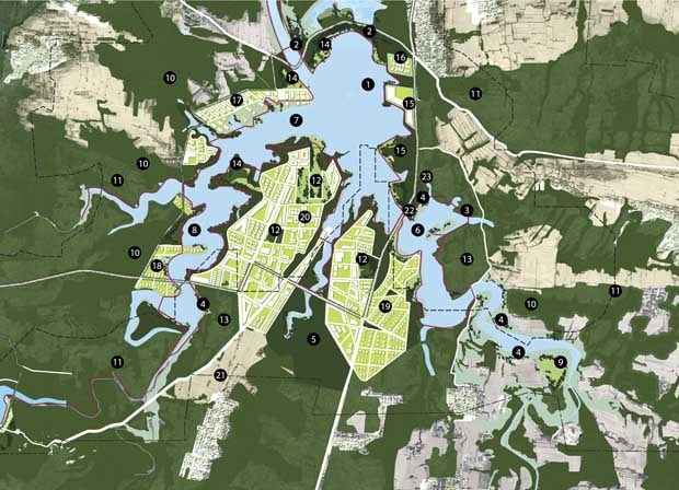
XinYang Suo River Comprehensive Plan, SWA Group

Words

A key consideration lies in how these ideas and strategies for urbanism are communicated—verbally and graphically. Defining what urbanism means is a good start. Urbanism and its many derivatives—new urbanism (Duany), ecological urbanism (Mohstaven) everyday urbanism (Chase), and Mayne’s recent entry, combinatory urbanism—while all slightly different in focus, each share a common goal of addressing the challenges of urban densities. (Please see, for instance, 60 modifiers to urbanism.) Among these terms, of course, is landscape urbanism: an idea that landscape and urban processes are inseparable; that we must look at the landscapes in our cities and the landscapes of our cities.

Purely semantics? Maybe. Conjecture? Possibly. Worth talking about? Absolutely. The study of cities needs to include many points of view in order to move beyond outmoded planning diagrams that no longer describe how to improve our cities. Despite so many variables, each of these terms argues for an ideas-rich platform for public debate, competition, and academic research in which the specificity of a particular factor can be magnified, examined, and explored in context.

“The study of cities needs to include many points of view in order to move beyond outmoded planning diagrams that no longer describe how to improve our cities.”

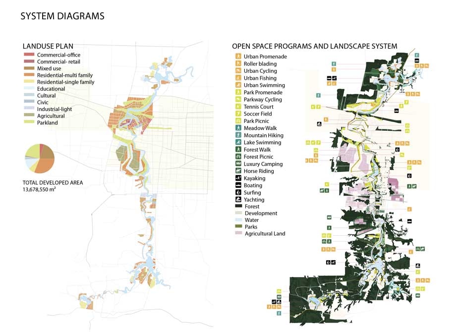
Diagrams: Land use and landscape open space,
XinYang Suo River Comprehensive Plan, SWA Group

Images

Understanding urbanism goes beyond theory and words, however. The collective visualization of our world—through imagery and visual representation of built and unbuilt projects in our everyday environments—is even more important in influencing how we understand and think about urbanism and landscape.

Due to the recent urban population explosions, we must begin to re-see our cities and systems and contextualize them within the larger landscape and its dynamics. At the same time, we are challenged to communicate our ideas in such a way that accurately represents proposals that offer adaptation and refinement to these volatile social and ecological conditions.

Because many of our projects are often without precedent—building entirely new stormwater retention systems; utilizing processes of bioremediation; re-programming existing infrastructure—we rely on visual representation to communicate our ideas of a better urbanism. The ability of landscape architects to communicate a set of design intentions is critical to gaining public acceptance, client approval, and, ultimately, building new places and inserting new ideas into our existing urban fabrics.

Furthermore, the issues addressed by urban designers and planners are so complex that the process of communicating ideas to the general public, city agencies, and stakeholders requires much more than a drawing. To this end, many landscape architects and planners are pulled to the re-representation model of visual reasoning.

As described by Rikva Oxman, understanding design proposals requires both cognitive knowledge and visual literacy. Oxman’s research explores how emergence, or the way complex systems arise out of relatively simple connections, informs creativity and, particularly, the process of design. Design then can be understood as a culmination of thousands of decisions—and each representation offers a layer of meaning behind these complex ideas. Our drawings and words are tools to communicate these ideas. The model of re-representation takes familiar planning diagrams and overlays them with adaptations or manipulations to reveal new relationships and possibilities for design proposals.

Buffalo Bayou, SWA Group.

Places

I want to argue, however, that there exists something more important than just words and visuals —that is, actual places. The collective images of the city and its components are created by the experience of real places in the real world. When communicating with the general public, we reference built projects and places as case studies to explain and bolster our visions.

For example, when a planner presents an image of “Main Street, USA” to a community group, everyone immediately draws upon their collective memory of what that is—small scale retail shops, promenading, benches, shade trees, festive banners, intimate street lights, dogs, and vibrant sidewalk activity. An image of Main Street is the basis of many new towns built around the world in the past twenty years.

Landscape architecture, however, suffers from a poor collective visual vocabulary. The absence of prevalent and progressive design precedents hinders our ability to communicate our ideals for a better urbanism to a broader audience. While it was once suitable to show an image of Central Park in New York City to communicate the program of a park, we are now in search of examples that can represent and meet the new challenges our cities are facing. Certainly, a few of these kinds of landscapes exist, but they are not as widespread as picturesque parks and gardens and, therefore, not as common to the general public for reference.

A more challenging example than “Main Street” is one that attempts to address ecological systems within the city. How does one visualize nature in the city? How does one convince the public that ecological cycles are needed in the urban context? What is the sales pitch? Are there examples for dynamic (and hidden or invisible) landscapes and ecological processes within urban life?

“Landscape architects, planners, and urbanists need built precedents to demonstrate that a more integrated approach to landscape and urbanism is possible.”

Using associative thinking is natural to how we represent and interpret a new situation, allowing for new ideas to step forward and grow (note 4). Yet, if new possibilities for landscape in the urban context remain unfamiliar or cognitively impenetrable, how are communities expected to endorse plans proposing integrated ecologies within busy streets and dense housing? How do we convince the public to do what has not yet been done before?

The answer: build them. Educate through practice. Landscape architects, planners, and urbanists need built precedents to demonstrate that a more integrated approach to landscape and urbanism is possible. Policy and planning does not spark a collective re-imagination of our future in the way that tangible, built work does.

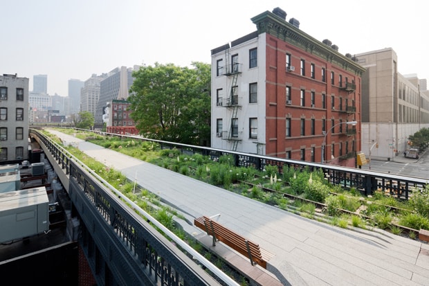
Even in the midst of a global economic downturn, designers have steadily been working towards a better urbanism, pushing forward a collection of new projects that are starting to gain public recognition. Cities like Detroit spark intense debate in the possibilities that landscape urbanism offers; the High Line and Academy of Sciences are two glamour projects that add to our collective vocabulary. Perhaps the recently built Buffalo Bayou, the Anning River master plan, or the future London post-Olympic legacy landscape afford fresh views for how people, ecology, transit, and open space can co-exist. Over the next decade, as the work communicated in words and pictures transforms into real places in the world, the public understanding of both urbanism and landscape architecture will expand, while new challenges and opportunities emerge for designers to tackle.


AQUINO_GERDO_FACEGerdo Aquino is the President of SWA Group and an adjunct associate professor of the Master of Landscape Architecture program at the University of Southern California. As an academic and practitioner, he seeks to promote landscape infrastructure through both research and large-scale commissioned projects. He’s also the coauthor of the book Landscape Infrastructure.


Note 1:  http://www.city-data.com/city/New-York-New-York.html, http://www.city-data.com/city/Los-Angeles-California.html, http://www.demographia.com/db-dense-nhd.htm
Note 2: http://quickfacts.census.gov/qfd/states/00000.html
Note 3: Remi Nadeau,The Water Seekers. Santa Barbara. Crest Publishers. 1997. 11-15
Note 4: Giovanni Gavetti, The New Psychology of Strategic Leadership. Harvard Business Review. Volume 89, July-August 2011, 118-127.

Grounding Landscape Urbanism

Introduction: Extending Landscape Urbanism’s History

In practice, landscape and urbanism have been held apart by professional boundaries, which are reinforced by divergent tactics and working scales. Joining these two terms into a hybrid methodology, as landscape urbanist practitioners have recently done, has sparked new ways of approaching the condition of cities as vast horizontal networks. Landscape urbanism promotes a “disciplinary realignment where landscape supplants architecture’s role as the basic building block of urban design.” (note 1) This collision of terminology and methodology has contributed greatly to current design discourse. At the same time, the prevailing effort to present landscape urbanism as a new, emergent discipline obscures a substantial lineage of thought that bolsters its credibility, if not its claim for originality. Prioritizing landscape as the foundation for a sound urbanism, and doing so through synthetic, interdisciplinary practice, has strong roots in the work of the earlier urban theorists Patrick Geddes, Lewis Mumford, and Benton MacKaye. While landscape urbanists mention these important thinkers who broke the molds of top-down planning methods, they offer little discussion of the continuities between landscape urbanism and this history of urban critique based in the landscape.

Australian landscape architect Peter Connolly refers to the “default” understanding of landscape urbanism, as defined in North America by Charles Waldheim and James Corner in The Landscape Urbanism Reader (note 2) and Praxis 4: Landscapes (note 3). In these texts, Waldheim and Corner seem invested in a perception of their work as a break from past practices, as a unique praxis poised to address new urban situations. This emphasis on newness allows their work to be appreciated as emergent, in connection with the same ecological spontaneity landscape urbanists hope to nurture in practice. Stressing the newness of their approach, however, isolates it as an intellectually autonomous body of thought, rather than a flexible, historically integrated working method. I will be responding to this “tacitly agreed upon idea of what landscape urbanism is,” (note 4) questioning the need for the field to be developed as an “ism” linked to a particular self-proclaimed genealogy and practice, rather than as an open set of principles that can guide the current practice of landscape architecture, urbanism and architecture.


Center 14: On Landscape Urbanism (note 5) presents a collection of historical essays that inform landscape urbanism. Yet this history only goes as far back as Ian McHarg’s Design with Nature in 1969. Setting the stage for McHarg, however, Patrick Geddes, Lewis Mumford, and Benton MacKaye foresaw the need to approach the city with new vision and strategies. Central to their approaches to what Mumford termed “living urban tissue” (1969), and Geddes called “conurbation” (1923), is an understanding that landscape underlies urban order.

As a city disperses, it loses its complexity and charge. Geddes, Mumford and Mackaye offer ideas for how to recapture this vitality in the new, expansive urban form. These historic writings suggest how landscape urbanism might be strengthened by greater attention to cultural and ecological landscape identity. Rather than focus on an essentially architectural understanding of urbanism-as-program and landscape-as-surface, these theorists recognize how landscape can generate infrastructure and how urbanism is formed by cultural interaction in the landscape over time.

Geddes, Mumford and MacKaye support a synthetic, interdisciplinary approach to a hybridized city. A hybrid approach can deal with current urban conditions where distinctions between urban and rural have blurred. James Corner writes that landscape urbanism “is a proposition of disciplinary conflation and unity, albeit a unity that contains, or holds together, difference—difference in terms of the ideological, programmatic, and cultural content of each of those loaded and contested words, ‘landscape,’ ‘urbanism’.” (note 6) In their descriptions of the urban condition and the approach it calls for, Geddes, Mumford, and MacKaye all support conflations of disciplines and categories traditionally held distinct. Their writing and suggested methods disrupt binary understandings of city/country, urban/rural, and human/nature. Much like landscape urbanists, these three promote new images of an interconnected city-landscape rather than viewing cities as a corruption of nature. They stand apart from tendencies that posit environmentalism as the conservation of designated wilderness areas, instead seeking to integrate natural forces and human settlement. They each, at least rhetorically, also eschew top-down planning methods that seek to apply abstract, rational means of ordering urban dynamics. Instead, they look to systems of order that pre-exist in the landscape and underly a heterogeneous cultural cohesion within particular regions. They pursue an urbanization that maintains the identity of place by effectively integrating these categories and preventing homogeneous and clumsy settlements.

Above a buried stream channel, a hedgerow colonizes the parking lot, reclaiming a lush, biodiverse link to the forest.

Patrick Geddes: Synthetic Thinking and the Regional City

Patrick Geddes applied his background in botany and the natural sciences to the study of cities. He advances an idea of the new, synthetic city as a concentrated expression of the rural area around it, rather than distinct or opposed to it. Geddes develops his idea of the “Valley Section” out of his analysis of how bounded cities were diffusing into what he termed “conurbations,” or interconnected city-regions. (note 7)

The Valley Section, which traces a diagrammatic slice from a river’s source in the mountains to its mouth at the sea, attempts to convey how human adaptations have developed in relation to their position and reveal how the zones of a landscape are linked by a common waterway. This method, which applies botanical concepts of plant distribution (note 8), explores a region’s potential while revealing elements of landscape as ecological and cultural markers of identity. His method emphasizes the importance of an interrelationship between settlement, culture, and landscape, and communicates this relationship between people and place through a section cut. The section is able to illuminate particulars of geography and how it affects culture—information that would be lost in the flattening qualities of a plan.

Instead of suggesting a boundary or limit to growth, Geddes suggested a reverse rural-urban colonization that is less nostalgic than opportunistic, sharing qualities with landscape urbanism’s hope of reintroducing complex ecologies in degraded sites. In Geddes’ “synoptic vision of Nature,” nature is preserved not through separation from humans, but rather through a heightened relationship developed by cultivation (sylviculture, arboriculture, and park-making). Geddes suggests that when landscape is cultivated as the foundation of urbanism, a durable, complex integration between city and landscape becomes possible. Creating the synthetic city “is more than engineering: it is a master-art; vaster than that of street planning, it is landscape-making; and thus it meets and combines with city design.” (note 9) This hardly seems far from James Corner’s claim that “landscape drives the process of city formation.” (note 10)

Akin to current landscape urbanist thinking, Geddes’ work encourages what he calls a “synthetic form of thought.” His “polymathic wanderings between disciplines” are influenced by a commitment to “the reconciliation of science, morality and aesthetics.” (note 11) Within his overarching goals of cooperation, he sees the value in connecting theoretical inquiry with practical application. Geddes’ desire for synthesis translated into the development of graphs he termed his “thinking machines” which sought to codify all arenas of life into thirty-six categories of interrelationship.

While Geddes’ goal of synthesis remains compelling, his attempt to grasp complexities within such a defined format curtailed the potential scope of his work. Mumford, Geddes’ reluctantly critical student, identified what he saw as a contradiction in Geddes’ hope for a synthetic form of thinking and his vision that such a synthesis would arrive at an end point, rather than at a productive instability or flexibility. Mumford writes, “the possibility of constructing such a ‘final’ synthesis was, in terms of [Geddes’] own most vital insight, a delusion. Synthesis is not a goal: it is a process of organization, constantly in operation, never finished. Any attempt to produce a single synthesis for all times, all places, all cultures, all persons is to reject the very nature of organic existence.” (note 12) Underlying Mumford’s unease with this approach is his strong conviction in the necessity to honor situated knowledge and distinctions of identity. While Geddes’s developed intellectually in a period of hope, Mumford’s outlook was tempered by the infusion of war-torn despair. (note 13,14) This difference, perhaps, explains Mumford’s deeper discomfort with totalizing theories and methodologies.

A network of social and ecological connections is forecast to interweave over time.

Lewis Mumford: A Search for Urban Complexity

Geddes and Mumford both value the importance of the region as a place defined from within and they create new vocabulary and methodologies to address it. In his book, The City in History, Mumford introduces the idea of emergence as key to understanding how a city develops:

In emergent evolution, the introduction of a new factor does not just add to the existing mass, but produces an over-all change, a new configuration, which alters its properties…. The old components of the village were carried along and incorporated in the new urban unit; but through the action of new factors, they were recomposed in a more complex and unstable pattern than that of the village—yet in a fashion that promoted further transformations and developments…. Out of this complexity the city created higher unity. (note 15)

In defining the city as a “complex and unstable pattern” and the basis for ongoing “transformations,” Mumford sets up the characteristics of mutability and fertile, complex tensions as both essential to a city. He describes the transformation of the city as a walled entity to its current state of fragmentation as an explosion: “the city has burst open and scattered its complex organs and organizations over the entire landscape. The walled urban container indeed has not merely broken open: it has also been largely demagnetized, with the result that we are witnessing a sort of devolution of urban power into a state of randomness and unpredictability.” (note 16, 17) The cultural productivity the walled city was able to foment was lost in urban dissolution. This obsolete, bounded city, “through its very form held together the new forces, intensified their internal reactions, and raised the whole level of achievement…. As with a gas, the very pressure of the molecules within that limited space produced more social collisions and interactions within a generation than would have occurred in many centuries if still isolated in their native habitats, without boundaries.” (note 18) Here, Mumford makes an argument that the interactions generated by the spatial qualities of the bounded historic city must find a new impetus in the “exploded” city. While the bounded city eventually became too limited and lost its productive efficacy, dispersed cities have yet to find comparable catalysts for the needed collisions, interactions, and reactions. Yet, as the landscape urbanists who follow, Mumford valued a horizontal tapestry of interspersed urban and rural characters, what he called a “green matrix.” He does not set urbanization, generally, opposite an archaic image of nature as untangled from human settlement. Rather, he argues against the sort of urbanization that is unresponsive to the particularities that compose a region as both ecologically and culturally unique.

To pursue viable urbanism, we must look at the scale of the region. A region is large enough to hold heterogeneity and small enough to support distinct, but shared values. Its diversity and values develop from of culture’s actions on its geographical substrate. In this view—which tightly links social and ecological aspects of a place—ecological influences prevent the human tendency to oversimplify, a tendency exemplified by the suburbs. (note 19) Mumford points out that suburbs were a critique of over-engineered, cramped urban space. They offered a type of settlement where domestic requirements could respond to landscape qualities, favoring minimal built intervention instead of maximized engineered efficiency.

The problem is not in the suburb’s lower density, but rather in that this type of urbanization over time became decreasingly responsive to the regional landscape while also recreating rural problems of isolation, problems met only by coarse transportation infrastructure. Consequently, this heavy-handed infrastructure recreated the rigid control characteristic of urban order that suburbia sought to escape. (note 20) Therefore, Mumford rejects suburban development for lacking the complexity that he regards as necessary in a city. He writes that the suburb is the “anti-city” and its development “annihilates the city whenever it collides with it.” (note 21) As opposed to his view of the city as complex and alive with emergent social conditions, in the isolation fostered by the suburb “nothing can happen spontaneously or autonomously—not without a great deal of mechanical assistance.” (note 22) In order for a dispersed city to gain viability, then, it will have to support multiple scales of space and time. Further, it will have to regain the fertile tensions and collisions that Mumford claims the city has lost in its “demagnetization” by creating greater diversity in its extended “green matrix.”

A filigreed armature, reinforcing latent landscape networks, overtakes the coarse grain of auto-centered infrastructure.

Benton MacKaye: Geotechnics, Revealing Infrastructure in the Landscape

Benton MacKaye’s strategies of “geotechnics” explore how the landscape itself can provide organization for the city as a charged field. As Mumford distinguishes between the regional inflections of a “green matrix” and the non-responsive character of “low grade urban tissue,” MacKaye sets apart development that is “genuinely urban, which furthers an active community life and produces a good environment, and metropolitan growth, which wipes out a good part of community life and produces a deteriorate environment of both town and country.” (note 23) For MacKaye, metropolitan growth follows the lines of least resistance, while “genuinely urban” growth is a mosaic of integrated urban and rural elements particular to a region. Geddes labels MacKaye’s practice “geotechnics” presenting it as an alternative to technocratic principles, as MacKaye embedded technology into geologic order. Geotechnics, itself a hybrid term, combines “geography, forestry and conservation, engineering colonization, regional planning, and economics.’” (note 24) Though MacKaye’s proposals address the political, economic, and cultural aspects of the landscape, they develop out of his background in natural sciences, particularly his study of dynamic geologic processes. In this way, the multi-disciplinary scope of his regional projects favor a “composite mind” to address complex issues.

MacKaye saw the city and surrounding countryside through their connective flows rather than as a bounded urban figure set in a separate, uniform rural field. For example, he diagrams Boston as a “mouth” of flow, or a consumer of the region’s economies, while showing its link to its surrounding countryside as a “source” of population flow. With his emphasis on flows, MacKaye could leap easily across scales, mapping the landscape infrastructures of a locality or expressing the world as an interconnected system of traffic. In focusing on the connections between city and its surroundings, MacKaye’s work confounds neat distinctions between the urban and rural, while his conflation of hydrological processes with human movement confronts the propensity to set people apart from the mechanisms that drive natural systems.

MacKaye hoped to cultivate viable urbanism by activating landscape as the underlying structure for a heterogeneous urban mosaic. Characteristic to his approach is that, rather than proposing extensive building projects, he suggests new ways of seeing the potentials that already exist and are offered in a landscape’s structure, so that it may be culturally activated. For MacKaye, the work of a regional planner is related with that of a civil engineer in how “he does not create his own plan, he discovers nature’s plan; he reveals a hidden potentiality which nature’s laws allow.” As such, a planner is “a man who finds rather than plans a region’s best development: one who builds on the actualities disclosed by exploration.” (note 25) Rather than looking for an abstract order, MacKaye understood that many systems of order are latent within the landscape itself, and that, often, a shift in vision alone makes these systems operative. In terms of sustainability, this approach is highly relevant, as it involves little material expenditure or heavy construction to enforce a change, but rather is tactical in that it focuses on the most minimal intervention to spur the most fundamental re-ordering. As Charles Waldheim writes, an approach centered around landscape is more viable than the “‘weighty apparatus’ of traditional urban design [that] proves costly, slow, and inflexible in relation to the rapidly transforming conditions of contemporary urban culture.” (note 26)

Mumford also forecast the necessity to respond to changing, collapsing urban conditions with more adaptive strategies. He voices a concern that is later echoed by the landscape urbanists’ emphasis on adaptability: “the more the energies of a community become immobilized in ponderous material structures, the less ready it is to adjust itself to new emergencies and to take advantage of new possibilities.” (note 27) In accordance with MacKaye, Mumford denounces infrastructural and urbanization efforts that neglect the opportunities of a site in favor of elaborately engineered means of accommodating poor initial choices. The priority that Mumford and MacKaye share, to maximize the potential of the landscape and minimize dependence on permanent, built solutions, offers a regionalist precursor to landscape urbanism’s current intentions.

Landscape Urbanism: Veering Toward the Formal Field Operation

Though Charles Waldheim professes a desire for landscape to replace architecture as the fundamental building block of urbanization, (note 28) much landscape urbanist work makes little effort to draw out the systems of order inherent in the landscape that would make this possible. Rather, these practices paradoxically seem to suppress differentiations existing in sites in favor of promised overlays of future order. Current North American landscape urbanists express faith in abstract systems, such as the grid, for finding order in the vastness of the “mat city.” James Corner writes optimistically:

…the grid has historically proven to be a particularly effective field operation, extending a framework across a vast surface for flexible and changing development over time, such as the real estate grid of Manhattan, or the land survey grid of the Midwestern United States. In these instances, an abstract formal operation characterizes the surface, imbuing it with specificity and operational potential. This organization lends legibility and order to the surface while allowing for the autonomy and individuality of each part, and remaining open to alternative permutations over time. This stages the surface with orders and infrastructures permitting a vast range of accommodations and is indicative of an urbanism that eschews formal object making for the tactical work of choreography, a choreography of elements and materials in time that extends to new networks, new linkages, and new opportunities. (note 29)

Mumford’s call for local variation leads him to a very different conclusion about the organizational grid, noting its effective use toward singular, economic ends. Mumford denounces speculative grids as “spectacular in their inefficiency and waste” due to the standardized scale of its units, which end up causing equal infrastructural resources to be allocated, regardless of the scale of occupation. In this way, this abstract order neglects the particularities of site, such as wind, light, soil and topography, in favor of formal consistency.

Corner trades the “formal object,” rejected by landscape urbanism, for a field he proclaims to be an “abstract formal operation.” The grid’s very abstractness as an applied order challenges the claim that it might be capable of “imbuing” a place with “specificity.” Implicit is a conception of sites as devoid of “operational potential” until the designer applies it, or, as Koolhaas writes, directs the “irrigation of territories with potential.” (note 30) In light of the landscape urbanist effort to value the landscape as the primary medium for structuring cities, the idea of infrastructure as something added or overlaid on the landscape seems counterproductive. This application of an external order becomes an act of obfuscation of the landscape rather than a revelation of the landscape’s specificities. The first step to a landscape urbanist approach might instead account for the landscape as infrastructure, and then find ways to plug in to it, expand, and adapt it to accommodate the activities and settlement of people. The orders already present in the landscape—even those obscured through histories of human disregard—provide the urban structure, the field becomes operative.

As the application of abstract order reflects a disconnection from larger landscape systems, it also allows for arbitrary limits to be drawn on a site. A focus within the outline of a parcel prevents the potential to elucidate what Robin Dripps describes as a site’s “special repository of clues,” or indications of larger systems too expansive to be contained in a small parcel. As fragments, these “clues” offer opportunities for potentially vital diversity “in their ability to be combined, reconfigured, or hybridized without the formal or intellectual compromises suffered by a more complete or closed entity.” (note 31) .

By not acknowledging the sites’ already dense potential, sites are represented as neutral and without agency. This tendency follows Koolhaas’ lineage by developing systems of order through applied programmatic possibilities rather than found site qualities. As landscape urbanists are acting in a landscape carved by the engines of undifferentiated urbanization that Mumford, Geddes and MacKaye fought against, it becomes even more difficult, but no less important, to see the links between these places and the stories that lace them with cultural significance and ecological richness. Peter Connolly takes issue with this tendency in landscape urbanism, exemplified in Alex Wall’s idea of the “urban surface.” Wall equates areas of extended, horizontal urbanism with abstract space. Abstracting the specifics of landscapes becomes a liability, where, in contrast to claims of landscape shaping urban interventions, the “very abstractness of this surface seems to liberate architects into the landscape.” (note 32) Ensuing applications of abstract order suggest a certain degree of determinism that landscape urbanists critique in common planning practices.

Complementing a map: a notational system conveys experiential qualities of a forest perceived in a walk—that of wind, sound, enclosure, and ground.

In Support of Middle Scale, Subjective Methods

One danger in such abstraction is the distancing of not only techniques for understanding and representing the landscape, but the ability of the landscape, structured by abstract orders, to foster stronger connections with its inhabitants. The representational distance, epitomized by the aerial view and the seeming authority of digital site representations, suppresses the subjectivity of a site and hence the communication of its identity.

This tension also underlies the sense of authority a map confers and its true subjectivity. James Corner’s mapping techniques and theories, which do embrace the map’s subjectivity, have significantly shaped current landscape architecture practice. At the same time, Corner’s maps connote a sense of power by hiding their subjectivity, allowing them to maintain an aura of authority. Corner celebrates this authority as a map’s key means of agency. Yet, because maps are, as Corner writes, “extremely opaque, imaginative operational measurements,” maps must be accompanied by other, experiential forms of notation and description. (note 33)

Mumford critiqued Patrick Geddes’ abstract, inflexible graphic method for a similar guise of authority. Despite Geddes’ claim to the universal applicability of his graphic method, it was, in fact, a deeply personal approach developed to compensate for a temporary blindness. Mumford was bothered by a disjuncture between the rigidity of Geddes’ graphic analysis and another method Geddes also practiced: walking and experiencing a city first hand. Geddes, an avid supporter of walking as a way of knowing, called for lived experience as the primary means of understanding the city. Mumford’s own belief in the vitality and value of cities derived from personal observations made during his systematic urban walks. Mackaye, as an adolescent, began to develop maps of the forests based on his observations of their character and terrain. His idea of regional planning, then, began with an experiential cartography. (note 34)

Walking has been pursued and discussed as a practice that addresses many of the same problems landscape urbanism tackles, that of modernism’s totality and universalistic tendencies. Walking addresses alienation by valuing a vantage point on the ground, one rejected by the predominant methodology and scales so far employed by landscape urbanist practitioners. Walking offers an embedded understanding of a place, as the “city is sliced and exposed by a walk, constructing a grounded view rather than the remote, overhead, ‘all-seeing’ vantage point of a traditional map. The eye in the sky is so detached that the…[city] is shown devoid of citizenry.” (note 35) From this perspective it becomes clear that “the city might best be understood and designed in section—the plane of perception—rather than in plan, the plane of construction. The walk, here, constitutes a pop-up sequencing of the city in four dimensions.” (note 36) A complex understanding of a place made possible through walking argues for the necessity of situated, notational methods to accompany aerial mapping techniques.

In Waldheim’s discussion of West 8’s work, he argues that their strength, and a characteristic he values in a landscape urbanist approach, lies in a de-emphasis on “the middle scale of decorative or architectural work and favoring instead the large scale infrastructural diagram and the small-scale material condition.” (note 37) In leaping back and forth between the total intimacy of the individual condition and the large scale, “latent” relationships that exist outside of the range of human perception this bipolar expression of landscape urbanism reinforces—rather than challenges—the experience of living in an undifferentiated horizontal city. On the ground, the experience of the “mat city” is characterized by both intense isolation as well as the disorientation that results from being overwhelmed by a scale larger than a person can conceptually grasp. Jumping from the individual scale to the synoptic totality skips over the middle scale where interactions occur. For urbanism to be landscape urbanism, it must engage this experiential human scale, the subjective scale in which relationships between people and between people and place occur. This is the middle scale of public interaction in which Mumford’s “social collisions” occur and where community is expressed. The scale of experience, therefore, beyond merely “decorative,” is actually the scale at which we develop and communicate both meaning and identity in the landscape.

Conclusion: The Garden City Revisited

While Lewis Mumford, Patrick Geddes and Benton MacKaye are all remembered for their roles as urban theorists and planners, they contribute to current landscape urbanist principles not only the vocabularies and methodologies they developed in response to shifting urban conditions, but also a fundamental consideration that the creation of real cities relies on the existence of a shared, locally situated landscape identity. Both the scale of human experience and the concept of the garden come into play as means for creating cultural traction in changing landscapes. The garden, as a site where shared cultural and natural authorship is undisputed, is a useful analogy for the aims of landscape urbanism. Culture may be linked to the cultivation of landscape, generating new overlapping social and ecological sources of productivity. Lewis Mumford makes the claim that the creation of a viable urbanism will depend not on the preservation “of the primeval, but extending the range of the garden, and introducing the deliberate culture of the landscape into every part of the open country” (emphasis added). He recognizes that “the culture of the environment” is not entrenched enough in our consciousness. (note 38)

While historical urban thinkers are often dismissed by landscape urbanists—perhaps because the alarm these theorists express seems antiquated in a post-industrial urban realm—a re-examination of their views reveals a legacy that values interrelationships between culture and landscape, urban and rural. These writers bolster landscape urbanism’s potential to develop key strategies of urban sustainability, drawing on relationships embedded in the landscape to cultivate vital, rooted cities. I echo Chris Macdonald’s hope that, as the discipline of landscape urbanism “emerges, it might take delight in matters of subtle consequence alongside those of strategic insight.” (note 39)


Shanti Fjord Levy joined Andrea Cochran Landscape Architecture as a designer in 2009, after working for Nelson Byrd Woltz Landscape Architects and D.I.R.T.studio. She seeks ways for design to reveal landscape identity and to serve as a catalyst for engagement—with one’s senses, the passing of time, natural forces, and public life. 

Shanti earned a Master of Landscape Architecture and Master of Architecture from the University of Virginia, where she was awarded the top academic honor from both programs and served as editor for two volumes of the academic journal lunch. As recipient of the Pelliccia Traveling Fellowship, Shanti investigated layered edges in the city of Rome. Through design research, she has explored how water infrastructure can multitask as public space and developed tools to reclaim the suburban landscape. She has an undergraduate background in Latin American Studies and Visual Arts from Brown University.

A version of this article appeared in lunch, a student run publication at the University of Virginia’s School of Architecture.

Image Credits: All photos and work by Shanti Fjord Levy.


Note 1: Charles Waldheim, “Landscape as Urbanism” in The Landscape Urbanism Reader, ed. Waldheim. (New York: Princeton Architectural Press, 2006) 37.
Note 2: Ibid.
Note 3: Amanda Reeser and Ashley Schafer, eds., Praxis 4: Landscapes (2002).
Note 4: Peter Connolly, “Embracing Openness: Making Landscape Urbanism Landscape Architectural” in The Mesh Book: Landscape / Infrastructure, eds. Julian Raxworthy and Jessica Blood. (Melbourne: RMIT University Press, 2004) 76-103, 200-214.
Note 5: Center 14: On Landscape Urbanism , ed. Dean Almy. (Austin: University of Texas Press, 2007).
Note 6: James Corner, “Terra Fluxus” in The Landscape Urbanism Reader, ed. Waldheim. 23.
Note 7: Patrick Geddes, Cities in Evolution, (Reprint London: Knapp, Drewett and Sons, Ltd., 1949. Originally published 1915) 14.
Note 8: Volker M. Welter discusses the influence of biologist Charles Flahault’s plant survey work on Geddes, which used plant associations to identify economic possibilities of a region. Biopolis: Patrick Geddes and the City of Life (Cambridge: MIT Press, 2002).
Note 9: Patrick Geddes, Cities in Evolution, 52.
Note 10: James Corner, “Terra Fluxus,” 24.
Note 11: Ian Boyd Whyte in Foreword to Welter, Biopolis , xvii.
Note 12: Lewis Mumford, “The Geddesian Gambit” Lewis Mumford and Patrick Geddes: the Correspondence. ed. Frank G. Novak, Jr. (London and New York: Routledge ,1995), 362.
Note 13: Lewis Mumford, The Culture of Cities. (New York: Harcourt, Brace and Company, Inc., 1938) 311.
Note 14: Lewis Mumford, letter from March, 1923, in Novak, 171.
Note 15: Lewis Mumford, The City in History: Its Origins, Its Transformations and Its Prospects. (New York: Harcourt, Brace & World, 1969) 29.
Note 16: Ibid., 33.
Note 17: Ibid., 34.
Note 18: Ibid., 34.
Note 19: Mumford, The Culture of Cities, 320.
Note 20: Ibid., 510.
Note 21: Ibid., 505.
Note 22: Ibid., 513.
Note 23: Benton MacKaye, The New Exploration. (Urbana: University of Illinois Press, 1962) 39.
Note 24: Benton MacKaye quoted in Keller Easterling, Organization Space (Cambridge: MIT Press, 1999) 14.
Note 25: Ibid., 33.
Note 26: Waldheim, “Landscape as Urbanism,” 37, 39.
Note 27: Mumford, The Culture of Cities, 441.
Note 28: Charles Waldheim “Landscape as Urbanism,” 37.
Note 29: James Corner, “Terra Fluxus,” 31.
Note 30: Rem Koolhaas quoted in James Corner, “Terra Fluxus,” 31.
Note 31: Robin Dripps, “Groundwork,” Site Matters, eds. Carol Burns and Andrea Kahn. (New York, London: Routledge, 2005) 71.
Note 32: Kristina Hill “Urban Ecologies: Biodiversity and Urban Design” in Case: Downsview Park, Toronto. ed. Julia Czerniak. (London, Munich: Prestel, 2001).
Note 33: James Corner “The Agency of Mapping” reprinted in Center 14: On Landscape Urbanism, ed. Dean Almy.(Austin: University of Texas Press, 2007) 171.
Note 34: Mumford quoting MacKaye in his Introduction to The New Exploration, ix.
Note 35: Anthony Hoete, Reader On the Aesthetics of Mobility (New York: Black Dog Publishers, 2003) 56.
Note 36: Ibid.
Note 37: Charles Waldheim “Landscape as Urbanism,” 45.
Note 38: Mumford, The Culture of Cities, 448.
Note 39: Chris Macdonald “Machines of Loving Grace,” in Center 14: On Landscape Urbanism , ed. Dean Almy.(Austin: University of Texas Press, 2007) 211.

Infrastructure Adrift: West 8’s Shells

Image courtesy of West 8 urban design & landscape architecture.

The Design

Photographs of West 8’s installation along the Eastern Scheldt storm surge barrier in the Netherlands show a field of broad, high-contrast stripes, carefully composed of blue-black mussel and cream-colored cockle shells. A more recent look at the site shows a starker, but equally rich landscape.

Image courtesy of West 8 urban design & landscape architecture. 

The Dutch State Department for Roads and Waterways (Rijkwaterstaat) commissioned West 8 to create the design along a highway crossing Roggenplaat, one of several artificial islands used to construct the storm surge barrier. The Rotterdam-based landscape architecture firm shaped the island’s sand deposits into dunes and installed the shells. These plateaus were meant to work across scales and functions, providing habitat for sea birds with a pattern bold enough to impress passing drivers. Shortly after the project’s completion in a lecture he gave in 1995, West 8’s founding principal, Adriaan Geuze, listed the project’s “basic ingredients” as “ecology, infrastructure, weather conditions, building programs and people.” (note 1)

Image courtesy of West 8 urban design & landscape architecture.

Geuze emphasized the performative aspect of the landscape, maintaining that birds would self-segregate according to the shell pattern—dark birds attracted to dark shells and light birds to light shells—so that “When driving over or through those plateaus, you are facing a rhythm of black and white shells and black and white birds.” (note 2)

The design—termed the “Shell Project” by Charles Waldheim (note 3)—prioritizes perception, but is now imperceptible or, as a West 8 employee put it, “no longer recognizable.” The employee speculated: “It appears to be [un]done by human hands,” at least, “a couple years” ago. (note 4) Perhaps. Alternatively, the tidal nature of the low-lying site caused its disappearance. Unlike a dam, which creates a hard, fixed barricade against water pressure, a storm surge barrier allows tidal movement. Explanations aside, the patterns disintegrated and the project lost its corresponding ecological and visual impacts as the shells drifted away. Yet surprisingly, the project is cited as an example of landscape urbanism and the power of landscape to shape ecology and infrastructure, without acknowledgement of its fleeting existence. As Jimi Hendrix observed, “castles made of sand wash into the sea, eventually.”


The Search

I visited Roggenplaat last year out of interest in the landscape’s relationship to N57, the highway that crosses it. The highway extends forty-five miles along a man-made coastline of the southern province of Zeeland, crossing two major dams, as well as the barrier, atop the two longest sets of sluices in the world.

I drove and cycled across the barrier several times hoping to capture the driver’s view that I had seen in photographs. Failing to do so, I pulled over to explore the island on foot.


That vantage revealed a landscape similar to others along the barrier: concrete plateaus with riprap, loose stone piled at the water’s edge to mitigate erosion; or, in some areas, wide planes of stacked concrete modules. Despite the disappearance of the Shell Project and its sand dunes, birds touched down and weekenders lounged on the island’s hard surfaces. I was initially disappointed, having traveled so far to study the project. However, it later dawned on me that the project’s absence might be as significant to the dialogue of landscape urbanism as the design itself.


Flexible Infrastructure or Permanent Decoration

Landscape urbanists have praised the Shell Project for its integration of ecological and infrastructural programming, its manipulation of animal behavior, and its subversion of cultural expectations. In his influential essay, “Landscape Urbanism: A Genealogy,” Waldheim describes West 8’s work in general and the Shell Project specifically as “a practice of landscape urbanism in which the middle-scale of decorative or architectural work is abandoned in favor of the large-scale infrastructural diagram and the small-scale material condition.” (note 5) He goes on to evaluate the project’s refusal to “[camouflage]…ecological systems with pastoral images of nature that intend to provide stylistic and spatial exceptions to the gridded urban fabric” and contrasts the treatment of the road to that of other “urban parkways.” (note 6)

Indeed, with its hard geometry and angular planes, the design is anything but pastoral. However, the project is neither substantively infrastructural, nor is it urban, located further from any gridded urban fabric than most places in the small, densely developed country. Waldheim wrote that essay not long after the project’s completion, but the work continues to be discussed without mention of its disappearance. (note 7)

Linda Pollak’s 2006 description of the project as an “infrastructural installation” (note 8 ) also fails to acknowledge its deterioration—likely underway, if not wholly gone—some ten years after completion. Instead, she ascribes the project’s insubstantiality to the birds. In Pollak’s view, the Shell Project “sustains a tension between dynamic ethereality and concrete presence,” attracting the “uncontainable nature” of migrating sea birds “into a field that they inhabit in a way that is unstable even as it reproduces the design.” (note 9) Pollak’s definition of “infrastructural” is unclear in this instance. Regardless of its intentions, the installation was temporary, more like land art or even West 8’s Cow Project than infrastructure, and has in fact proved more ethereal than the birds it sought to affect.

Image courtesy of West 8 urban design & landscape architecture.

The installation was also—in contrast to Waldheim’s characterization—largely decorative, laid alongside rather than embedded within other layers of infrastructure and program. Geuze’s own description implicates its ornamental nature: the design aimed “to incorporate the awareness of [the interaction between infrastructure, people, and ecology] in a playful optimistic manner that stimulates the desire to take possession of space.” (note 10) While heightening sense of place and eco-literacy are important and commendable aspects of landscape architecture, playful stimulation does not imply the work or function of civil infrastructure.

Even if the design had lasted, it is not the Shell Project, but the storm surge barrier that reorders the relationship between ecology and infrastructure. (note 11) The barrier is a triumph of Dutch engineering and a crown jewel of the Deltawerken (Delta Works), a system of sixteen dams and dikes protecting the Dutch coastline from inundation. This particular section along the Eastern Scheldt or Oosterschelde coast was built in response to the catastrophic North Sea flood of 1953, which killed almost 2000 people. The storm surge barrier buttresses thick layers of infrastructure that sustain a programmatically diverse and ecologically dynamic landscape. Retaining tidal dynamics protects the estuarine ecology, as well as the commercial fishing economy.

Image courtesy of West 8 urban design & landscape architecture.

The state began constructing islands, including Roggenplaat, in the late 1960s to support the construction of a standard dam that would enclose the Eastern Scheldt estuary. Completing the storm surge barrier at costs much higher than a dam left insufficient funds for dismantling the islands as planned and eventually led to their development as recreational and ecological assets and to West 8’s commission. Droves of cyclists, motorists, nature enthusiasts, and fishermen now enjoy the islands, the barrier, and the N57 roadway. A more surprising development along the barrier, and perhaps a glib example of landscape urbanism, occurred on the nearby island of Neeltje Jans, where a Delta Amusement Park features water slides, marine mammals, and Delta Works–themed exhibits on one side of the road and a wind farm park on the other.

The road’s latest renovation, begun in 2002 and ongoing, is one of seven pilot projects balancing transportation improvements with ecological principles. These “eco-compensation” initiatives call for the replacement at a one-to-one ratio of all habitat compromised during road realignments. The slogan, “New Road, New Nature,” (note 12) promotes these efforts. Among the “new Dutch nature” is Oosterschelde National Park, the largest nature reserve in the Netherlands and designated in May 2002. The park consists of a string of recreational areas created by the barrier. As the Netherlands consists largely of land willfully reclaimed from the sea, the country’s policies treasure its tenuously held terrain, designating nature areas even out of agricultural or urban landscapes without the irony and “scare quotes” that frame debates on nature, wilderness, and other culturally loaded terms in the United States. (note 13)

The contrast between the barrier’s austere utility and West 8’s erstwhile shell installation force us to confront challenges beyond the project’s early acclaims. The storm surge barrier—with its complex programmatic functions, sophisticated engineering, and costs—illustrates what landscape architects and urbanists face with ambitious infrastructural projects. Generally speaking, when infrastructure washes away unintentionally, it is considered a failure. The integration of infrastructural and public programming can impel social, ecological, and practical transformations. However, we must take on the seemingly contradictory synthesis of permanent armatures and dynamic cycles. We must modify our objectives against empirical evidence and clarify our intentions, lest the works of the landscape urbanist discussion become decorative and slip away unnoticed.


Laura Tepper spent part of 2010 exploring highway landscapes in Europe and North America as part of the Geraldine Scott Traveling Fellowship, awarded by UC Berkeley’s College of Environmental Design. She holds master’s degrees in landscape architecture + environmental planning and city planning, and currently practices landscape design in San Francisco.

Image Credits: All photos by Laura Tepper unless otherwise noted. 


Note 1: Adriaan Geuze, “Black and White” (lecture presented at the Doors of Perception 3 Conference, Amsterdam, The Netherlands, November 1995).
Note 2: Ibid.
Note 3: Charles Waldheim, “Landscape Urbanism: A Genealogy,” Praxis 4 (2002): 16.
Note 4: Personal conversation, June 2010.
Note 5: Waldheim, “Landscape Urbanism: A Genealogy,” 15.
Note 6: Ibid., 16.
Note 7: Recently: Fred Truniger, “Rhythm as an approach to landscape experience.” ‘SCAPE 1 (2010): 29-33. This issue of ‘SCAPE focused on roads and landscapes.
Note 8: Linda Pollack, “Constructed Ground: Questions of Scale,” in The Landscape Urbanism Reader, ed. by Charles Waldheim. (New York: Princeton Architectural Press, 2006), 137.
Note 9: Ibid., 138.
Note 10: Geuze, “Black and White.” Italics added.
Note 11: Waldheim, “Landscape Urbanism: A Genealogy,” 15. Paraphrasing of Waldheim’s characterization of the project as “imaginatively reordering relationship between ecology and infrastructure.”
Note 12: R.J. Davidse Aarts, “Recognizability Of Rural Roads In The Netherlands,” in Swov Institute For Road Safety Research, Leidschendam. (The Netherlands: Association For European Transport And Contributors, 2007).
Note 13: Geuze, “Black and White.” Geuze explains: “I am Dutch, and thus was born in a country with a very special relationship with nature…. The knowledge that the contemporary landscape is, for the most part, artificial allows this office the freedom to respond by positing its own narrative spaces.”
Project Info:
1990-1992, Roggenplaat, Zeeland, Netherlands
Client: State Department for Roads and Waterways
Team: Adriaan Geuze, Dirry de Bruin, Erik Overdiep, Huub Juurlink, Paul van Beek
Sources:
Aarts, R.J. Davidse. “Recognizability Of Rural Roads In The Netherlands.” In Swov Institute For Road Safety Research, Leidschendam. The Netherlands: Association For European Transport And Contributors, 2007.
Geuze , Adriaan. “Black and White.” Lecture presented at the Doors of Perception 3 Conference. Amsterdam, The Netherlands, November 1995. Accessed July 21, 2011, http://www.vanriet.com/doors/doors3/transcripts/Geuze.html.
Pollack, Linda. “Constructed Ground: Questions of Scale.” In The Landscape Urbanism Reader, edited by Charles Waldheim, 125-140. New York: Princeton Architectural Press, 2006.
Truniger, Fred. “Rhythm as an approach to landscape experience.” ‘SCAPE 1 (2010): 29-33.
Waldheim, Charles. “Landscape Urbanism: A Genealogy.” Praxis 4. (2002): 10-17.
Waldheim, Charles. “Landscape as Urbanism.” In The Landscape Urbanism Reader, edited by Charles Waldheim, 45-54. New York: Princeton Architectural Press, 2006.
“Landscape Design Eastern Scheldt Storm Surge Barrier, 1990-1992, Zeeland, The Netherlands,” West 8, accessed June, 2011. http://www.west8.nl/projects/landscape/landscape_design_eastern_scheldt_storm_surge_barrier/.


Visualizing Information

“The main goal of a data visualization is its ability to visualize data, communicating information clearly and effectively. It doesn’t mean that data visualization needs to look boring to be functional or extremely sophisticated to look beautiful. To convey ideas effectively, both aesthetic form and functionality need to go hand in hand, providing insights into a rather sparse and complex data set by communicating its key aspects in a more intuitive way.”

–Vitaly Friedman “Data Visualizations and Infographics” (2008)

 A year of meals visualized in more than forty ways by Lauren Manning.

The visualization of information tells us stories about how, what, and why things are happening. This information tells us what to do and how to do it, and even gives us clues about who we are and how we fit into the world. Information that is clearly presented shapes how we behave and directs future decisions.

At the same time, information can be overwhelming, confusing, and overbearing. Today, information flies at us at every moment of our lives. Molding it into something useful can be difficult. Yet, a visualization is more effective than a large, incomprehensible data set in that it sifts out what is pertinent and presents it in a legible form.

The art of distilling and translating masses of data into meaningful images requires precision and analysis. To begin the process of formally visualizing something, you have to know two things—your data and your audience. First, we mine the data to find a story—the trends, outliers, and aggregated correlations that explain what’s happening. Second, we have to figure out who we want to reach with this information. Learning about your audience—who they are, what questions they are asking, what information directs their decisions—influences how you illustrate the story.

There are many methods of visualization, four of which are particularly relevant to the fields of landscape, architecture, and urbanism: narrativeinfographicmapping, and diagrammatic. These methods work with many types of data and present multiple options for visual styling and clarification.

Narrative

Narrative visualizations tell a story with data. This mode of representation works best for data that is associated with time. With our reliance on words, this can be challenging to master visually, yet capturing these complex narratives reveals multiple layers of information.

For instance, narrative visualizations can be used to describe pedestrian traffic through a park over time, the frequency of tweets along the High Line during any given day, or to showcase occupancy and data trending of complex social and economic phenomena in public spaces. Narratives are often successful, but also the most challenging since every story is different and there is no consistent visual framework to use. Sometimes while designing these types of visuals, I find it helpful to bounce back and talk through the data. We are naturally more familiar with verbally describing stories and this exercise can help reveal implicit angles or outliers within the data.

NAPOLEAN’S MARCH by Charles Joseph Minard (1869)

Napoleon’s March, by Charles Joseph Minard, is one of the most successful data visualizations of all time and is often referred to by Edward Tufte. It’s a must-see classic in the field of data visualization as it tells a gripping story. It simultaneously shows four variables—time, path, number of men, and temperature—in one concise map of Napoleon’s failed campaign of 1812 into Russia. Stripped of erroneous colors and jargon that can camouflage a message, Napoleon’s March uses color, size, and labeling strictly for illustrating these particular factors. Temperature and time are shown relative to points along the march. The march itself is depicted in two colors: tan for the journey to Russia and black for the trip back, with the thickness of the line indicating the size of the army—and its dramatic decrease due to punishingly cold weather. Usually, capturing four variables is too ambitious for one drawing, but here the data points are driven by the close relationship of these factors of the march to and from Russia.

MAP YOUR MOVES by Moritz Stefaner

A second example of narrative storytelling lies in Moritz Stefaner’s imaging of the movements of residents into and out of New York City over the course of a decade. The interactive visualization “Map Your Moves” is an example of a narrative not based solely on space or time; rather, time is held constant (a decade), and geographic location is depicted through relationships rather than overlaid on a spatial map. Surveyed by the Brian Lehrer Show on the radio station WNYC, the story emerges through the moves of 1700 people in (blue) and out (red) of New York City, showing where they moved and why. By clicking on various bubbles, the viewer learns about the story gradually, through his or her own curiosity, rather than by trying to interpret all the information at once.

ONE HUNDRED MILLION CALLS by WIRED Magazine

The third example of visual narrative is a flow diagram of over 34,000 calls to 311 in New York City made in one week. The data set in its raw form is unusable, but by isolating the variables by time of day (a twenty-four hour period) and aggregating the calls into twenty-two categories of complaints, the flow diagram shows how and when people complain—and what they are calling to complain about. By using a bright color palette and fun visual method, this data becomes a story that is understandable, interesting, and useful. Immediately, we see outliers in the data, such as noise complaints at night versus a more even distribution of complaints during the daytime. As with this example, flow diagrams are good for revealing overall peaks, as well as relationships between categories.

Infographics

Infographics use both conventional methods—like pie charts and bar charts—and abstract methods—like web diagrams and dot clusters. These visualizations tend to balance imagery and typography. The imagery can be photographs, illustrations, or, commonly, vector-based drawings. Infographics take very large sets of numbers, often formatted as cells and tables in a spreadsheet, and use hierarchy, layout, and context to focus on certain elements of the data. They can also illustrate a small set of data, and are a flexible option for presenting statistics and facts.

Context and hierarchy are two of the most important components of data visualization and are especially important in infographics. Context provides the viewer with a reference to something that they already understand so that they can apply it to new information. For instance, referring to the size of a golf ball, instead of 1.5 inches in diameter, quickly orients the unfamiliar to something familiar. Football fields, large animals, and even skyscrapers can be used to show one object’s size in relationship to another. Visual hierarchy gives more weight to some of the information than to others, helping that data stand out and be seen or understood more immediately. Some of the simplest ways to illustrate weight or significance are scale, color, boldness, and placement on the page.

VIRTUAL WATER by Timm Kekeritz

Virtual Water is an excellent example of how a message can be communicated clearly using a strong and simple infographic system. The color palette of cyan and black, along with vector silhouette imagery, focuses solely on the pertinent information: how much freshwater is used in the production chain of popular products. This visualization was so successful that while initially a single poster, it then became a full series, a website, and an app used to tell the story of water usage.

METROPOLITAN WORLD ATLAS by Joost Grootens
A second example of a beautiful infographics is the book Metropolitan World Atlas which blends infographics with mapping. Throughout, Joost Gootens uses a strong pop of color, akin to an electric poppy, to call out data points on each page. Used alone or with city maps, bright dots scale to show relationships in data. The atlas covers a variety of information including population, crime, growth, density, and traffic. Rarely has such a simple visual and color system been able to work for such a large range of information. This style cannot work for everything, but when used successfully, proves highly effective and memorable.

Infographics can be used to describe phenomena and process in step-wise fashion; they can show relationships between scientific research and space-making; and they can be used to describe demographic breakdowns of particular cities and regions—although infographics are used in multiple other ways. Not all infographics are created equal, however, and can fail to communicate clearly. Be wary of mixing numbers with percentages, or comparing stats compiled by different sources. It is important to communicate the relationships within the data and to be clear about your message. A good rule of thumb is to try to tell one story at a time, and defer to simple means wherever possible. One of the biggest problems with infographics is trying to show too much information at once. Obvious hierarchy should be the first priority.

Mapping

Mapping is familiar to the fields of landscape, architecture and urbanism, but recent mapping has shown possibilities for growth, exploration, and improvement. Beyond marking locations, maps can be physical, digital, two-dimensional, three-dimensional, literal, abstract, black and white, colorful, and any number of other options. Mapping can seem overwhelming, often because users are trying to include a tremendous amount of information within a single drawing.  Done well, it is one of the most powerful forms of visual representation. Maps inherently tell two stories—geographic location and plotted data. The most successful maps are systematic, logical patterns of data distribution that, in their aggregate, show relationships between data and space.

RACE AND ETHNICITY: NEW YORK by  Eric Fischer (2010)
The 2010 mapping of Race and Ethnicity by Eric Fischer is a stunning visualization of the racial and ethnic divisions in major US cities. This data visualization takes a complex set of data and, through simple color coding and a consistent dot pattern, shows trends geographically. In the New York City example, the map shows White (red), Black (blue), Asian (green), Hispanic (orange) and Other (yellow). Each dot represents twenty-five residents. The distribution of racial populations is not uniform. Here, the data is start and geographic boundaries are reduced to thin grey lines. Stories surface within the image: Chinatown, for example, is a green cluster in downtown Manhattan; other neighborhoods show distinct and concentrated white and black populations, while parts of Queens are remarkably integrated.

NORTH SEA ATLAS by LUST

In the North Sea Atlas, the map by LUST reveals natural geography through data points. The team plotted the movements of the North Sea for twenty-four hours, with lines indicating the density and traffic of ship movement in and out of each port. Because of the density of traffic, the geography of the United Kingdom and the eastern side of Ireland becomes clearly delineated as if the landmasses themselves were included.

Diagrammatic

Diagrammatic representations visualize space in two- and three-dimensional form. Frequently used by architects and landscape architects to illustrate studies, process, and final rendering of building and landscape, successful diagrams are simple and tell one story at a time. Diagrams can be static or animated, and often contain layers of visual and typographic information. Often, a repeated set of diagrams will use the same framework, but highlight different information in each image so that the viewer can easily compare isolated sets of information.

LINCOLN PARK ZOO by Studio Gang
Lincoln Park Zoo by Studio Gang uses the simple outline of the zoo to distinguish the layers of program and design. This exploded axonometric diagram explains complex phenomena occurring within the same space. Instead of trying to show all the information on a single collapsed image, the separated layers make the information more digestible for the viewer. In this collection, the four diagrams indicate the zoo’s hydrology, wetlands, pond, and education pavilions so that one can begin to understand the reasoning behind the design. For instance, the proposal recommends excavating areas of the site in order to leverage water run-off so that water is filtered through the wetlands and before pooling in the pond.

VERTICAL VILLAGE by MVRDV (2011)

Diagrams are exceptionally useful in presenting ideas, conceptual frameworks, and spatial studies. As part of the Vertical Village exhibit in Taiwan, MVRDV explores vertical urban transformation and densification in East Asia through iterative diagrammatic modeling. These models show various configurations of programmatic elements typical of villages—living, farming, community space—within a single city block. This visual exploration is impressive: fun, informative, and stunning. It shows how far this visual method can be pushed and relies on the consistent use of color, scale, and material. Here, the power of this installation derives from the sheer volume and imagination of the designers’ manipulation of data.

Conclusion

Visual representation is a powerful and effective way to impart information. Each of these methods, in addition to others not described here, have a role in telling stories. Matching the data with the tool or technique is important. These frameworks can help make complicated or tedious information—research, data, facts, statistics, demographics, history, weather patterns, traffic, growth, and more—relevant and easy to understand. As with the race and ethnicity map, viewers may not know initially what a geo-located, color-coded data point means, but after looking at the map, they learn that a green dot in Manhattan’s Chinatown represents Asian occupants and the viewer can begin to get a sense of place and where and how this information fits together. The opportunities for communication skyrocket when lists and tables are curated into a visual story. And this is the ultimate goal of visual representation: to connect with an audience.


Lauren Manning is a multi-disciplinary designer and is currently a member of the Data Visualization team at R/GA, a New York City based digital agency. As part of her graduate thesis, she explored over forty ways to visualize a single data set, bringing an iterative design method to the visualization field. In addition to data visualization, she works in design systems, branding, print, packaging, typography, and social media marketing. Lauren holds a master’s degree in communication design from Pratt Institute and a bachelor’s degree in architecture from Clemson University.

From Hand To Land: Tracing Procedural Artifacts In The Built Landscape

Whether designing a building, operating on a patient, or cooking a meal, the tools of the trade leave their marks on the tradesman’s product. Take, for instance, the orbs and halos produced by flash photography, the lens flares resulting from aiming a camera into the sun, or the pixels of a digital image: in each example, the technologies of image creation (cameras) are indelibly imprinted onto the final output (photographs). As technologies advance, outputs change. For centuries, buildings were ornamented extrusions of simple geometric forms, surgeons relied on blades and sutures, and chefs chopped, pureed, baked, and sautéed. Today, technology has profoundly altered traditional methods. Digital modeling and fabrication techniques have enabled architects to build nearly any conceivable form with nearly any material. Nanotechnology and robotics have enabled surgeons to work with a degree of precision previously the stuff of science fiction. And chefs specializing in molecular gastronomy are utilizing high-tech lab equipment to serve up foams, spheres, and even flavored air.

Barcelona Botanical Garden designed by Carlos Ferrater and Bet Figueras.
Image credit: Alejo Bagué. From here
.

But what physical impact does rapid technological progress leave on the products and processes it enables? In other words, what are the tooling marks of the digital age? Buildings with intelligent control systems, surgical scars reduced to millimeters through laproscopic technology, and high-tech food—whether haute cuisine or processed foodstuff—are obvious examples. In photography, the lens flares, orbs, halos, and pixels that were once considered a nuisance, to be avoided or removed through post-production, eventually found a following among photographers who learned to control their appearance and harness them for the emotional and ephemeral qualities they evoked. The advent of photography software has transported the shortcomings of analog equipment into fine-tuned, intentional effects, evidenced today by the soaring popularity of iPhone applications such as Hipstamatic and Instagram, which mimic the desaturated palette of Kodachrome, the shadowed corners of a Holga lens, or the yellowing edges of vintage film papers.

The harnessing of procedural artifacts in photography translates well to the current treatment of digital media in landscape architecture. The advent of landscape urbanism, with its roots in mid-century movements in ecology and modernist planning (note 1), has, for the most part, freed landscape architects from the postmodern tradition of steeping projects in the signs and syntax of Western European garden tradition. While pre-millennial landscapes by Peter Walker, George Hargreaves, and Martha Schwartz Partners, among others, are imbued with social, historic, or stylistic semiotics in the vein of Bryson (note 2) or Venturi (note 3)—as exemplified by Schwartz’s Jacob Javits Plaza in New York (1997) and its signifiers of the formal French garden (note 4)—the Downsview Park (1999) and Fresh Kills (2001) competitions produced a profound paradigm shift by switching the focus to ecology. Following these competitions, contextual reference in landscape today generally points to a territorial, rather than formal, context: the natural and engineered systems that activate a site and give it character. Given that one of the prime motives of digital technology is to simulate and analyze the complex regional processes that affect local sites, it makes sense that there is a desire to leave visual traces of said technology on the built landscape, as doing so is a way of revealing evidence of larger contexts and hidden systems.

Barcelona Botanical Garden designed by Carlos Ferrater and Bet Figueras. From Google Maps.

Toolmarks: A History

As tools and techniques for simulation and design have aided a transition from landscapes rooted in historic formalism to landscapes centered on ecological and social performance, the resultant “toolmarks”—vestiges of the methods used to design these landscapes—have likewise changed. Indeed, over the centuries that spacemaking has been documented, technological developments have been instrumental in shaping the types of spaces that have been built, whether intentionally or not. Laurie Olin states this simply: “if you can’t draw something, you probably can’t make it.” (note 5)

With the exception of a handful of ancient anomalies that leave historians scratching their heads—crop circles, Stonehenge, various mounds and sacred landscapes by indigenous peoples, for example—Olin’s maxim has held true in landscape architecture as it has evolved from sacred prehistoric traditions into capricious landscape painting, aristocratic garden design, and finally its chameleonic present. Today, landscape architects are trained to be equally comfortable at scales ranging from residential gardens and pocket parks to urban infrastructure networks and regional ecological mosaics. In a parallel evolution, the primary medium in which landscape architects work has shifted from earth, to paper, to screen.

The gradual transition from paper to screen has been marked by several technology-induced milestones. Prior to the industrial revolution, the field-based approach of skilled craftsmen and master-and-apprentice workshops meant that garden-making required minimal design documentation, with scale-less field sketches being far easier and faster to make than plan and section projections. (note 6) In the 16th and 17th centuries, with the notable exception of Capability Brown, plans and constructed drawings were more often used to document landscapes after they were built than to aid in the actual design of the gardens: one example of this being the aerial perspective woodcuts used to document French and Italian villa gardens that were highly prized among the social elite. (note 7) In the late 18th century, Humphry Repton popularized the design drawing as marketing tool. Repton’s Red Books employed cleverly manufactured “before and after” overlays in which anemic sites were magically transformed into bucolic scenes by simply flipping the page. (note 8)

In the late 19th century, mechanical reproduction became a viable process and landscape architecture emerged as a profession separate from landscape gardening. Subsequent increases in scope and scale mandated a standardization of the general process of making landscape drawings: measured plan and elevation projections, cross sections, and material specifications began to surpass the role of on-site fieldwork. In the 20th century, seminal landscapes of the modern period—Dan Kiley’s Miller Garden, Thomas Church’s Donnell Garden, among others—were defined by a geometric vocabulary that was constrained by the tools used to design them—straight-edge, compass, protractor, French curve. Echoing parallel movements in art and architecture, geometric formalism dominated landscape architecture through the middle of the century: it appeared everywhere from Dan Kiley’s vegetal grids to Eckbo’s palm allees. In landform, technical drawing was apparent in the artful nod to the invention of contours evidenced by Lawrence Halprin’s Lovejoy Plaza, whose terracing so faithfully adheres to its contour plan as to treat the mathematics of grading with a kind of reverence.

Detail of topographic model for Guadelupe River Park, Hargreaves Associates, 1988-1990.
Image Credit: Collection of the Frances Loeb Library, Harvard Design School.

It was through landform that landscape architecture began to make its most direct transition from paper to screen. In the early 1980s, Hargreaves Associates began using a sandbox to model its signature earthworks at the suggestion of the artist Douglas Hollis, who collaborated on the firm’s Candlestick Point park project. (note 9) What began as an experiment rapidly became a critical step in the firm’s design process. Over time, sand was replaced by clay, and a clay-modeling workshop became a rite of passage for students at the Harvard Graduate School of Design during Hargreaves’ tenure as chair of the landscape architecture program. The iterative nature of clay modeling combined with its honesty to the “real” medium of landscape—earth—foreshadowed the omnipresence of 3D modeling as a means of testing landform permutations prior to construction. It is only recently, however, through digital fabrication and advanced material mapping, that these digital models are approaching the tactility and hand-worked qualities of their clay predecessors.

CAD systems for producing projected drawings—plans, sections, and elevations—also have their antecedents in pre-digital landscapes. In marked contrast to the curves in Thomas Church’s Donnell Garden, which are compound arcs that can be constructed with only a compass and straight-edge, the whimsical tropical gardens designed by Roberto Burle Marx in the 1950s and 1960s are characterized by freeform curves that are nearly impossible to replicate accurately by hand. This looseness is perhaps foretold by Burle Marx’s use of paint, rather than drafting ink, in his plans. To facilitate the continued use of freeform curves in a more constructed manner, designers turned to computers. In 1960, MIT’s Lincoln Laboratory produced SKETCHPAD, the first computer-driven drafting system. (note 10) SKETCHPAD and other computer-aided drafting systems rapidly calculated polynomial equations for freeform curves—or more technically, splines, so named for the flexible tools used to construct curves in analog drafting, especially for shipbuilding. (note 11) Given that straight lines are rarely found in nature, the digital mastery of curves has had a profound impact on landscape design: whereas formerly, landscapes manipulated or were situated in opposition to natural forms—think French gardens with their symmetry and formal vegetation, or the orthogonal landscapes of Dan Kiley or Peter Walker—landscapes today increasingly employ the geometry of nature—curves, tributaries, gradients—to seamlessly blend into their natural settings or reintroduce nature into an urban setting.

Beyond replicating the complex forms of nature, today’s digital processes have advanced to the point of accurately simulating large-scale ecological processes as well as realizing complex conceptual designs in built form. The parallel development of geodesign tools, environmental simulation software, BIM (Building Information Modeling), a variety of parametric engines (note 12), and advancements in digital fabrication have heightened the ability of landscape architects to engage at a high level in discourse previously the realm of experts in other disciplines. In landscape, the fields of biology, geology, and hydrology inform ecologically sound strategies, while engineering and architecture inform the construction of pre-fabricated elements, infrastructural systems, and complex earthworks.

Much has been written on the impact of design and fabrication technology on architecture. Indeed, a discussion of the expanded universe of employable geometry would be incomplete without referencing William Mitchell’s shape economies. (note 13) In architecture, the notion of economies of shape—progressing from the simple forms enabled by traditional drafting instruments to the limitless library of complex curves and patterns that have been unlocked by computers—largely provokes a discussion of formal typologies. Generally, when function enters the equation, it has yet to move beyond the novel tectonics of structural systems and building skins—and as much emphasis is placed on ornament as performance. Does the lack of structural economy seen in works by Zaha Hadid, or the elaborate articulation of facades seen in projects such as Jean Nouvel’s Institut du Monde Arabe, have a strong enough performative argument to justify the monumental cost of construction, or are they merely formally interesting?

Performance is a major factor that separates landscape architecture from architecture, and similarly digital relics, at their most effective, weave their way into landscape performatively, not formally. Let us return for a moment to Laurie Olin’s refrain: we can only build what we can draw. The fact that today we can draw just about anything has enormous implications for the built landscape, and requires enormous restraint by the landscape architect to ensure that technology is employed to appropriate means. Agency certainly comes into play when one considers that computers are increasingly the workhorses in both design and construction. However, a more interesting issue is that some aspects of the landscape are inherently undrawable. (note 14) Landscape is defined by expansive, indefinite spatiality; living materials that grow, weather, and decay; and temporal cycles that span hours, days, seasons, and epochs. (note 15) In consideration of these ephemera, which distinguish landscape from any other form of spatial practice, how can digital tools be harnessed to understand, manipulate, and emphasize qualities that are, by their very nature, constantly in flux? The following catalog of procedural artifacts—a sampling of the ways in which digital media activates and marks landscape today—attempts to answer this question by evaluating digital design methods for their ability to engage spatiality, temporality, and materiality, in an effort to underscore the criticality of environmental and social performance in contemporary landscape architecture.

Barcelona Botanical Garden designed by Carlos Ferrater and Bet Figueras.
Image credit: Alejo Bagué. From here
.

Digital Relics in Landscape Architecture: A Catalog

Faceting
One of the most common digital artifacts in both landscape and architecture is the faceted surface. Arising, like the spline, as a mathematical approximation of complex curvature in CAD software, the faceted mesh is to a curved surface as a multi-sided polygon is to a circle. By manipulating the degree of triangulation, meshes can approach smoothness, or appear jagged or angular. It is this angular quality of a faceted mesh—a low-resolution analog of a high-resolution surface—that has fascinated digitally-inclined designers of late. Faceted surfaces, more perhaps than any other digital artifact, are direct results of the software in which they are designed. A common cross-pollinator between geographic analysis and landscape design is the TIN, or Triangulated Irregular Network: a tessellated surface formed between geographic coordinates in GIS (Geographic Information Software) that can be exported and manipulated in 3D modeling software. Because they require little memory, meshes are the native format in many 3D modelers commonly used today. To display smooth results, coarse angular meshes can be automatically subdivided many times over. The fact that users can easily toggle between smooth and angular modes with a single keystroke is perhaps responsible for a generation of young designers who view landform more easily in three-dimensional space than in plan or section: it is now exceedingly simple to think as a computer does, abstracting nearly any form into a wireframe structure or a faceted planar surface.

Examples of the faceted landform are increasingly prevalent, particularly among architect-designed landscape projects (Foreign Office Architects’ La Gavia Park, Herzog and de Meuron and Vogt Landschaftsarkitecten’s Laban Dance Center) and among Spanish designers (RCR Arquitectos, Vicente Guallart)—the latter of whom were doubtless inspired by one of the earliest examples of the faceted planar landform, the Barcelona Botanical Garden by Carlos Ferrater and Bet Figueras. Ferrater and Figueras’ proposal used computer modeling software to develop a triangular grid as a framework for planting and infrastructure in the garden: each triangular plane, retained by a series of COR-TEN steel walls, features a different Mediterranean plant community, with the slope and solar aspect of each plane mimicking ideal growing conditions in the plants’ native setting. (note 16) The triangular planes also provide a built-in system for evenly distributing an irrigation network through the garden, which is deployed across the same triangular grid as the planting beds. Even the visitor’s experience is guided by the faceting system, as paths follow the triangular network across its slope. In this sense, faceting transcends mere formal aspects and becomes inextricably embedded into both the function and experience of the garden.

Gwanggyo City Center: rendering by MVRDV. Image from here.

Mimesis
The ecological rigor that gives landscape urbanism its credibility also gives rise to an easy error: mimesis. All too often, the emphasis which landscape architects place on analyzing regional conditions and determinants, drawn from procedures tried and perfected in ecological planning as promoted by McHarg, Geddes, and others, (notes 17 and 18) results in a fascination with, if not fetishization of, mathematical and tectonic morphologies in nature. In this sense, technology acts as an enabler: the accuracy and ease of simulation and modeling software—for computing flows of surface and groundwater, tracking solar angles and predominant winds, modeling terrain, etc.—result in precise, complex mappings of environmental, biological, geological, or social phenomena. The novelty and aesthetic appeal of these mappings make them formally generative in a way heretofore rarely seen: too often this yields awkward scalar translations between regional and local scales or macroscopic and microscopic systems, prompted by desires to embed metaphor and context into design. Far from being confined to novice projects, these effects are common in competition entries and built work by established landscape architects and architects. Mimesis as a procedural artifact can be subtle or overt. For example, the MVRDV’s China Hills Exhibition and Gwanggyo Power Center and Vicente Guallart’s Denia Mountain and Wroclaw Expo (note 19) are speculative, unbuilt proposals that reduce highly specific geological operations—subduction, delamination, sedimentation, erosion—to superficial envelopes containing regularly spaced floorplates that belie the geomorphologies that inspired them. (note 20)

Governor’s Island as mollusk: rendering by James Corner Field Operations. Top image from here. Lower image from author’s collection.

To be fair, biomimicry often produces elegant proposals that enhance the performance of landscapes by using natural processes as the vehicles through which a site’s challenges can be addressed. For example, James Corner Field Operations and Wilkinson Eyre’s proposal for New York’s Governor’s Island, entitled Mollusk, reimagines the filter-feeding anatomy of mollusks as a series of earthworks. These earthworks act as cleansing biotopes for the tidal water in New York Harbor, as well as flood mitigators for the developed portion of the island. In this project, 3D modeling software allowed for precise testing and refining of the mollusk-inspired landforms under a variety of tidal and flood scenarios.

Keio University. Image from here.

Recursive Patterning
One of the more obvious examples of a computer-aided process revealing itself in built form is the explosion of algorithmic and parametric patterning in architecture and more recently landscape architecture. By harnessing lightning-quick computational processes, such as recursion, iteration, and conditional application of rules (parameters), it is now possible to quickly create highly complex field conditions that respond to structural, environmental, or aesthetic conditions. The fine grain of these patterns would have been exponentially more difficult, if not impossible, to achieve manually, and as such was rarely seen until recent decades—notable exceptions being Islamic architecture and the work of Antonio Gaudí. As in the work of the Moors and Gaudí, much of today’s algorithmic and parametric work in architecture rests firmly in the realm of ornamentation and the subdivision and rationalization of complex structures. While digital fabrication technologies such as water jet cutting, 3D printing, and CNC milling (note 21) have made it possible to build nearly any parametric façade or structure, they also make it all too easy to impose unnatural or excessive geometry that fails to respond to site conditions.

Keio University. Image from here.

So, how can these patterns transcend ornamentation and become performative? In landscape, attempts at performative parametrics have often focused on gradients composed of discrete units that adjust in response to changing conditions. At their simplest, these gradients change incrementally as their topographical namesake implies: in response to slope. For example, to respond to hydrology, slopes have been articulated as impermeable fields punctuated by apertures that become incrementally larger where water collects, or as variably-sized paving units in a permeable field. An example of the aperture in the impermeable field is Michel Desvigne’s Keio University Roof Garden in Tokyo. In this project, rather than responding to slope, concrete tiles are perforated in a gradient pattern in order to allow patches of vegetation to poke through. Not only does this allow for the same unit paving system to be used for walkable surfaces and planting beds, it also helps to delineate and enclose paths.

Busan Cinema Complex: rendering by James Corner Field Operations. Image from here.

An example of paving units in a permeable field is the Busan Cinema Complex competition entry by James Corner Field Operations and TEN Arquitectos. In this project, topography stretches over subterranean water retention bladders. To subtly reveal the position of the bladders, the ground is articulated with a field of pavers that decrease in size where the bladders deform the surface.

Busan Cinema Complex: rendering by James Corner Field Operations. Image from here.

Design of paving units for Busan Cinema Complex developed by James Corner Field Operations.

While these two projects were certainly dependent on parametric modeling and computational simulation software—Keio University, for the creation of paving units, and Busan, for the topographical modeling and allocation of a slope-dependent field of pavers—hydrological gradients as a means of marking the groundplane are not new.

Land imprinting. Image from here.

One of the more innovative precursors is the Dixon land imprinting machine that, like the mill marks left by a CNC milling machine, employs a toothed roller attached to a bulldozer to emboss a pattern of V-shaped troughs and seeds into compacted soil. (note 22) This mechanical technology, if paired with the conditional adaptation enabled by parametric software, has enormous potential. By feeding sensor data into the machine, it could vary the depth and scale of the roller teeth and the speed of the bulldozer in real time, allowing it to respond to slope, the compaction or chemical makeup of soils, moisture content, and more.

Land imprinting. Image from here.

It is not difficult to imagine modifications to the Dixon machine that could be used to plant phytoremediative vegetation in response to contamination, break up asphalt in military sites or repurposed infrastructure, or introduce hydrophilic vegetation in areas that collect more water. By seeking economies of scale, whether through mass-produced paving units or sensor-fed equipment, parametric patterns can allow landscapes to easily respond to on-site conditions with a high-degree of specificity and little additional time and cost.

Yokohama Port Terminal. Photo ©Andrea Hansen 2009.

Topology
Ever since Rem Koolhaas and Bernard Tschumi gained worldwide acclaim for their schemes for the Parc de la Villette design competition in 1982, the line between architecture and landscape has come in and out of focus. This is due at least in part to an interest among many designers in blurring the lines between ground and enclosure. Architects are no longer satisfied designing walls and roofs, and landscape architects are not content to simply add greenery around the buildings. Rather, hybrid conditions have emerged in which ground becomes roof, walls fold into floors, and greenery creeps onto vertical walls and vegetated roofs. Topology—the mathematics of continuous, seamless surfaces—has been explored by artists such as Max Bill and M.C. Escher throughout the 20th century. Only through 3D modeling, however, have non-Euclidian and topological surfaces gained widespread use in the design of habitable spaces. The development of NURBS (non-uniform rational basis splines) curves and surfaces, which are manipulated by a cage of finite control points, allow complex continuous surfaces to be easily modeled even by novice users. Meanwhile, built-in operations for flattening or “unrolling” geometry and calculating ribs and cross-sections allow these surfaces to be panelized and codified so that they can actually be built.

Yokohama Port Terminal. Photo ©Andrea Hansen 2009.

One of the earlier examples of a topological landscape is the Yokohama Port Terminal by Foreign Office Architects (FOA), begun in 1995. This project utilized 3D modeling software (Microstation) to construct a continuous surface whose undulations allow it to act interchangeably as ground, roof, wall, and ceiling. In the built project, continuous curvature is achieved by using a system of wooden planks that are present on both the interior and exterior surfaces.

Southeast Coastal Plaza. Photo ©Andrea Hansen 2009.

The theme of topological curvature reappears in a later project by FOA, the Southeast Coastal Plaza in Barcelona (2000-2004). (note 23) In this project, a single unit (a crescent shaped paver) is deployed across the site, changing from pathway to amphitheater, skate ramp, and retaining wall. Though some design details have been overlooked—apertures for drains and tree planters, for instance—the project succeeds in creating a continuous surface that is enclosed yet almost entirely accessible. As modeling software improves and rapid prototyping of 3D models becomes faster and cheaper, the boundaries between architecture (enclosure) and landscape (ground) will become increasingly porous. It is important, however, that the built outcomes of 3D surface modeling become more than manifestations of forms floating in a model space unencumbered by real-world scale, context, and materiality. By registering localized ecologies such as solar angles, panoramas or barriers, or active and passive zones, topological decisions can become intelligent drivers of the way people experience landscape.

Southeast Coastal Plaza. Photo ©Andrea Hansen 2009.

Conclusion: Digital Media and Performance

The act of classifying procedural artifacts is not a question of authorship: the four categories outlined above speak less to the presence of the designer’s hand, skill, or intuition, and more to a transparent use of digital technology. (note 24) True, the designer plays a vital role in even the most computationally advanced schemes: she devises the generative logic, sets and resets the parameters, chooses the permutations, and creates the drawings. Nonetheless, remnants of the computational toolkit have a persistent, unmistakable syntax that evokes the back-end mathematics of design software: the meshes and surface analogs, the computational algorithms, the back-and-forth, do-and-undo recursion involved in translating concept to code. The real question of agency is raised by the intentionality of these digital relics. Is it necessary or even effective to leave traces of the technology we use on the landscape? Does the rapid turnover of what is “cutting edge” in computational design and the gap between conception and construction—over many months, if not years—leave landscape architects susceptible to seeming passé even before a project’s newly-planted trees have time to set roots? Or is the act of embedding contemporary thought, design, and fabrication processes into the built landscape as critical to the historical documentation of this epoch as it was when Mies ushered in the structural honesty of modernism with his adoption of the mantra, “less is more?”

Perhaps the answer lies less in the whims and wherefores of designers and their critical allies, and more with the people who experience landscapes on a daily basis with little awareness of, or care for, spatial logic, let alone the toolmarks that the design process leaves on a site. An excellent example of the way that trained and untrained eyes have wildly differing perceptions can be found in the comparative sketches of roadside landscapes in The View From the Road by Donald Appleyard and Kevin Lynch. (note 25) Ultimately, qualitative successes are what make landscapes great at any scale: the social relationships they engender, the ecological and environmental benefits they impart, the ephemeral delights—whether the sheer pleasure of walking in dappled sunlight under a leafy canopy, or the relief of dipping one’s feet in cool water on a hot summer’s day. The successful examples cited in this essay embrace the artifacts of digital media not for their formal qualities, but because, in some way, the chosen forms support the performance of the landscape. Technology helps to make sense of our complex world, and at its best it helps translate environmental and social processes into designs that bring people together, improve underperforming sites, and promote healthy cities. Moreover, as a core aspiration, technology enables landscape architects to focus on what they do best: creating vibrant, dynamic, and robust landscapes that enable plant, animal, and human inhabitants to thrive.


For more examples of the varied ways in which digital media is revolutionizing landscape architecture, check out the projects in the Digital Terrain series in strategies: Aidan Acker’s Sited: Digital Strategies, Allison Dailey’s Underworld, and Max Hooper Schneider’s Monist Kingdoms. See also A. Scottie McDaniel’s catalog of representational instruments, Patterns of Representation, for further breakdown of contemporary representational techniques and how they are employed in the conceptual realm.


Andrea Hansen is Daniel Urban Kiley Fellow and Lecturer in Landscape Architecture at Harvard University’s Graduate School of Design, where she teaches core and option studios and lectures on representation and advanced digital media. Her research and design practice, Fluxscape, focuses on the development of responsive landscape infrastructural frameworks that express urban and ecological contexts through ephemera and gradients. Andrea holds a Master of Landscape Architecture and a Master of Architecture from the University of Pennsylvania, where she was the recipient of several awards including the George Madden Boughton Prize, the Warren P. Laird Award, the William M. Mehlhorn Scholarship, and the Van Alen Traveling Fellowship. She also holds a Bachelor of Arts in Urban Studies and Civil Engineering from Stanford University.


Note 1: See Meg Studer’s interview of Charles Waldheim in this issue of landscape urbanism (dot) com for further discussion of landscape urbanism’s roots in ecological planning.
Note 2: Mieke Bal and Norman Bryson, “Semiotics and Art History,” in Art Bulletin 73, no. 2 (Jun., 1991): 174-208.
Note 3: Robert Venturi, Steven Izenour and Denise Scott Brown, Learning from Las Vegas: The Forgotten Symbolism of Architectural Form (Cambridge, MA: MIT Press, 1977).
Note 4: “Jacob Javits Plaza, New York, New York,” Martha Schwartz Partners, accessed November 12, 2011. http://www.marthaschwartz.com/projects/javits_details.html
Note 5:  Laurie Olin, “Drawings at Work,” in Representing Landscape Architecture, ed. Marc Treib. (New York: Taylor and Francis, 2008). “Drawing is an act of thinking. If you can’t draw something, you probably can’t make it.” 155.
Note 6: Ibid. “While equal in age to drawings for building, landscape documents have experienced greater difficulty in achieving accurate representations. . . . One traditional method first creates a recognizable view and then alters it by redrawing or overlay, annotating the new view with comments on the work intended.” 144.
Note 7: Dianne Harris and David Hays,  “On the Use and Misuse of Historic Landscape Views” in Representing Landscape Architecture, ed. Marc Treib. (New York: Taylor and Francis, 2008) 22-41.
Note 8: Stephen Daniels, Humphry Repton: Landscape Gardening and the Geography of Georgian England (New Haven, CT: Yale University Press, 1999).
Note 9: Kirt Rieder, “Modeling, Physical and Virtual,” in Representing Landscape Architecture, ed. Marc Treib. (New York: Taylor and Francis, 2008).
Note 10: Marian Bozdoc, “The History of CAD,” accessed October 17, 2011. http://www.mbdesign.net/mbinfo/CAD-History.htm
Note 11: As with splines, today’s CAD systems find the basis for many tools—fillets, chamfers, lines, and arcs—in hand-drafting techniques, just as Photoshop’s core digital tools reference analog techniques (paintbrush, pencil, and eraser from drawing, dodge and burn, from photographic printmaking).
Note 12: Grasshopper for Rhinoceros 3D and Bentley’s Generative Concepts, for example.
Note 13: William J. Mitchell, “Foreword” to Kostas Terzidis, Expressive Form: A Conceptual Approach to Computational Design. (London, UK: Spon Press/Routledge, 2003).
Note 14:  Robin Evans, “Translations from Drawing to Building,” Translations from Drawing and Building and Other Essays. (Cambridge, MA: MIT Press, 1997). “Not all things architectural . . . can be arrived at through drawing.” 159.
Note 15: James Corner, “Representation and Landscape: Drawing and Making in the Landscape Medium,” Word & Image 8, no. 3 (July-Sept 1992) 243-275.
Note 16: Carlos Ferrater, Synchronizing Geometry. (Barcelona, Spain: Actar, 2008).
Note 17: See also Meg Studer’s interview of Charles Waldheim in this issue of landscape urbanism (dot) com for further discussion of landscape urbanism’s roots in ecological planning.
Note 18: See also Shanti Fjord Levy’s “Ground Landscape Urbanism” in Issue 1 of this journal.
Note 19: Vicente Guallart, Geo-Logics: Geography, Information, Architecture. (Barcelona, Spain: Actar, 2008).
Note 20:  It is perhaps indicative of the sometimes conflicting priorities of landscape architects and architects that all of these projects were architect-designed.
Note 21:  For an excellent and highly-readable overview of digital modeling fabrication technologies, see Branko Kolarevic, “Digital Morphogenesis” and “Digital Fabrication” in Architecture in the Digital Age: Design and Manufacturing. (London, UK: Spon Press, 2003).
Note 22:  For more information, see http://imprinting.org/.
Note 23: Foreign Office Architects, Phylogenesis: FOA’s Ark. (Barcelona, Spain: Actar, 2004).
Note 24: For a discussion of the traces of authorship in the process of making, see the critique of James Turrell in Robin Evans, “Translations from Drawing to Building,” in Translations from Drawing and Building and Other Essays. (Cambridge, MA: MIT Press, 1997).
Note 25: See also issues of disjuncture as presented in experienced vs. drawn translation of Rittenhouse Square in Jane Jacobs, The Death and Life of Great American Cities. (New York: Random House, 1961).

On Landscape, Ecology, And Other Modifiers To Urbanism

Over the past year, an emergent discourse of “ecological urbanism” has been proposed to more precisely describe the aspirations of an urban practice informed by environmental issues and imbued with the sensibilities associated with landscape. This most recent adjectival modifier of urbanism reveals the ongoing need for re-qualifying urban design as it attempts to describe the environmental, economic, and social conditions of the contemporary city. Equally, it acknowledges that the now well-established discourse around landscape urbanism is entering a mature phase of its development.

Landscape urbanism emerged over the past decade as a critique of the disciplinary and professional commitments of neotraditional urban design and an alternative to “New Urbanism.” The critique launched by landscape urbanism has much to do with neotraditional urban design’s perceived inability to come to terms with the rapid pace of urban change and the essentially horizontal character of contemporary urbanization across North America and much of Western Europe. It equally has to do with the inability of neotraditional urban design strategies to cope with the environmental conditions left in the wake of deindustrialization, increased calls for an ecologically informed urbanism, and the ongoing ascendancy of design culture as an aspect of urban development. The established discourse of landscape urbanism is seemingly entering a robust mature phase, at once no longer sufficiently youthful for the avant-gardist appetites of architectural culture, yet growing in global significance as its key texts and projects are translated and disseminated globally. One aspect of this maturity is that the discourse on landscape urbanism, while hardly new in architectural circles, is rapidly being absorbed into the global discourse on cities within urban design and planning.

The established discourse of landscape urbanism as chronicled here and other venues sheds interesting light on the ultimately abandoned proposal that urban design might have originally been housed in landscape architecture at Harvard. One reading of José Luis Sert’s original formulation for urban design at Harvard is that he wanted to provide a transdisciplinary space within the academy. But urban design has yet to fulfill its potential as an intersection of the design disciplines engaging with the built environment. In the wake of that unfulfilled potential, landscape urbanism proposed a critical and historically informed rereading of the environmental and social aspirations of modernist planning and its most successful models. In so doing, it proposes a potential recuperation of at least one strand of modernist planning, the one in which landscape offered the medium of urban, economic, and social order.

One particularly enduring aspect of urban design’s formation over the past quarter century has been the ongoing investment within its discourse to traditional definitions of well-defended disciplinary boundaries. This is particularly revealing for contemporary readers, since it contrasts markedly with recent tendencies toward a cross-disciplinarity within design education and professional practice in North America. Several design schools have recently dissolved departmental distinctions between architecture and landscape architecture, while others have launched specifically combined degree offerings or mixed enrollment course offerings. This shift toward shared knowledge and collaborative educational experience has come partly in response to the increasingly complex inter- and multi-disciplinary context of professional practice. And those practices have undoubtedly been shaped in response to the challenges and opportunities attendant on the contemporary metropolitan condition. In this context, urbanism has recently been modified by adding the adjective landscape or ecological.

From this perspective, the recent discourse around urban design’s histories and futures seems ambivalent toward the project of disciplinary despecialization found in so many leading schools of design. Cities, and the academic subjects they sponsor, rarely respect traditional disciplinary boundaries. In this respect, the design disciplines should not expect to be an exception, and many leading designers have called recently for a renewed transdisciplinarity between the design disciplines. Unfortunately, far too much of urban design’s relatively modest resources and attention have been directed toward arguably marginal concerns in contemporary urban culture. Among these, three points are the most obvious and vulnerable to the integrity of the urban design discipline.

First, by far the most problematic aspect of urban design has been its tendency to accommodate the reactionary cultural politics and nostalgic sentiment of “New Urbanism.” While leading design schools have tacked smartly in recent years to put some distance between themselves and the worst of this 19th-century pattern-making, far too much of urban design practice apologizes for it by blessing its urban tenets at the expense of its architectonic aspirations. This most often comes in the form of overstating the environmental and social benefits of urban density while acknowledging the relative autonomy of architectural form. I would argue that urban design ought to concentrate less attention on mythic images of a lost golden age of density and more attention on the contemporary urban conditions where most of us live and work.

Second, far too much of the main body of mainstream urban design practice has been concerned with the crafting of “look and feel” of environments for destination consumption by the wealthy. Many have called for urban design to move beyond its implicit bias in favor of Manhattanism and its predisposition toward density and elitist enclaves explicitly understood as furnishings for luxury lifestyle.

Finally, urban design’s historic role of interlocutor between the design disciplines and planning has been too invested in public policy and process as a surrogate for the social. While the recent recuperation of urban planning within schools of design has been an important and long overdue correction, it has the potential to overcompensate. The danger here is not that design will be swamped with literate and topical scholarship on cities, but that planning programs and their faculties run the risk of reconstructing themselves as insular enterprises concerned with public policy and urban jurisprudence to the exclusion of design and contemporary culture.

It is in the contexts of urban design’s as yet unrealized promise and potential that landscape urbanism has emerged in the past decade. Landscape urbanism has come to stand as an alternative within the broad base of urban design historically defined. Incorporating continuity with the aspirations of an ecologically informed planning practice, landscape urbanism has been equally informed by high design culture, contemporary modes of urban development, and the complexity of public-private partnerships. While it may be true, as has been recently argued, that the urban form proposed by landscape urbanism has not yet fully formed, it would be equally fair to say that landscape urbanism remains the most promising alternative available to urban design’s formation for the coming decades. This is in no small part due to the fact that landscape urbanism offers a culturally leavened, ecologically literate, and economically viable model for contemporary urbanization as an alternative to urban design’s ongoing nostalgia for traditional urban forms. Evidence of this is found in the number of internationally prominent landscape architects who have been retained as lead designers of large-scale urban development proposals in which landscape offers ecological function, cultural authority, and brand identity. Further evidence is found in the fact that many promising young urbanists have explicitly embraced a landscape urbanist agenda. This increasingly global recognition reveals landscape urbanism’s impact on a generation of professionals shaped by the tenets of an adjectivally modified urbanism, be it landscape urbanism, ecological urbanism, or whatever supersedes those two.

In his introduction to the Ecological Urbanism conference, Mohsen Mostafavi described the subject of the conference as simultaneously a critique of and a continuation by other terms of the discourse around landscape urbanism. (note 1) Ecological urbanism, just as the landscape urbanism discourse did a decade ago, aspires to multiply the thinking on cities to include environmental and ecological concepts and to expand traditional disciplinary and professional frameworks for describing those urban conditions. As a critique of the landscape urbanist discourse, ecological urbanism promises to render that decade old discourse more specific to ecological, economic, and social conditions of the contemporary city.

Mostafavi’s introduction to the topic suggested that ecological urbanism “ … implied the ‘projective’ potential of the design disciplines to render alternative future scenarios.” He further indicated that those alternative futures might place us in various “spaces of disagreement.” These spaces of disagreement span across a range of disciplinary and professional borders. Any serious attempt to examine those spaces must begin with the acknowledgement that the challenges of the contemporary city rarely respect traditional disciplinary boundaries.

In reading the new language proposed by the ecological urbanism initiative, the subtitle of the conference itself “Alternative and Sustainable Cities of the Future” indicates the linguistic cul-de-sac of contemporary urbanism, constructed around a false choice between critical cultural relevance on the one hand, and environmental survival on the other. The conference title and subtitle further signify disciplinary fault lines between the well-established discourse on sustainability and the long tradition of using urban projections as descriptions of the contemporary conditions for urban culture.

This suggests that ecological urbanism might reanimate discussions of sustainability with political, social, cultural, and critical potential. This is particularly apt as contemporary discussions of the city reveal a profound disjunction in which environmental health and design culture are opposed, a condition in which ecological function, social justice, and cultural literacy are perceived as mutually exclusive. This disjunction of concerns has led to a condition in which design culture is depoliticized, distanced from the empirical and objective conditions of urban life, while at the same historical moment, increased calls for environmental remediation, ecological health, and biodiversity suggest the potential for reimagining urban futures. One result of this disjunction has been that we are forced to choose between environmental health, social justice, or cultural relevance.

It is no coincidence that an adjectivally modified form of urbanism (be it landscape, ecological, or other) has emerged as the most robust and fully formed critique of urban design over the recent past. The structural conditions necessitating an environmentally modified urbanism emerged precisely at the moment when European models of urban density, centrality, and legibility of urban form appear increasingly remote and when most of us live and work in environments more suburban than urban, more vegetal than architectonic, more infrastructural than enclosed. I believe that these structural conditions for urban practice and the disciplinary realignments attendant to them will persist, as our language morphs and transforms in an ultimately incomplete, yet completely necessary attempt to describe them.


A version of this article was originally published in Topos 71: Landscape Urbanism; it is reprinted here with permission from the author.


Charles Waldheim is John E. Irving Professor and Chair of Landscape Architecture at Harvard University’s Graduate School of Design. He coined the term “landscape urbanism” in 1996 to describe emergent practices at the intersection of urban design and landscape architecture.


Note 1: Mohsen Mostafavi, “Introduction,” Ecological Urbanism Conference, Harvard Graduate School of Design, April 3, 2009.

An Interview With Charles Waldheim: Landscape Urbanism Now

“With the birth of these new technologies and these new economic processes, one sees the birth of a sort of thinking about space that is no longer modeled on the police state of urbanization of the territory, but that extends far beyond the limits of urbanism and architecture… It was not architects, but engineers and builders of bridges, road, viaducts, railways, as well as the polytechnicians—those are the people who thought space… the technicians or engineers of the three great variables—territory, communication and speed.

                                                                 —Michel Foucault, “Space, Knowledge, and Power” [1]

 “Anybody wanting to grasp the originality of the era (20th century) has to consider [together]: the practice of terrorism, the concept of product design, and environmental thinking. With the first, enemy interaction was established on a post-militaristic basis; with the second; functionalism was enabled to re-connect to the world of perception; and with the third, phenomena of life and knowledge became more profoundly linked than ever before. Taken together, all three mark an acceleration in “explication.” In other words: the revealing-inclusion of the background givens underlying manifest operations.

—Peter Sloterdijk, “Gas Warfare—Or the Atmoterrorist Model” [2]

The High Line, New York City. Image courtesy of Jim Corner Field Operations.

Preludes and Positions 

At the dawn of the 21st century, landscape urbanism draws together the infrastructural intensities of “territory, communication, and speed” and the “explicit” deployments of ecological efficiencies. Current projects—like that of Clare Lyster, Alan Berger, Pierre Belanger, Keller Easterling, Infranet Lab, and RVTR—elaborate on the divergence of information flows and production chains [3]. Their analysis—of resource/waste webs, the spatial dross of consumption sites, and hybridized highway proposals—asks how, where, and what forms of aggregate agency and intervention might be grounded in today’s urban logistics.

At the same time, the research of those in geography and the social sciences, such as John May and Ulrich Beck, explores how the tools and techniques of environmental planning—satellite/Landstat infrared imaging, serial and statistical simulations—have evolved out of the atomic arms race and military models of risk [4]. Their excavation of MERC origins asks how our construction of ecology and environment, as epistemological and material formations, can balance social intimacy, economic development, and a bio-political potential for annihilation. Focused more widely than on “landscape” or “urbanism” specifically, landscape urbanist research has staked out these recent and broader spatial concerns for its discourse of design.

Throughout this period, Charles Waldheim has been a strong advocate for landscape urbanism. The current chair of landscape architecture at the Graduate School of Design (GSD) at Harvard and former dean at the University of Toronto, Charles’ Landscape Urbanism Reader (2006) was instrumental in the articulation and promotion of the approach through the voices of practitioners [5]. Since then, his own articles and his advisory role on the GSD’s New Geographies Series (with Bruno Latour, Antoine Picon, and others) have engaged the adjacent fields of history of science, political and economic geography, sociology, and architecture in this complex spatial research. Thus, between discourse and deployments, Charles’ guidance and support has contributed to the emergence of landscape urbanism as a platform and “glocal” manifestation from which to query the territorial intensities, socio-economic flows, and environmental entanglements of globalized, capitalist governance and development.

I sat down with Charles to discuss how current events, in politics and economics, were inflecting and resonating with landscape urbanism’s operative models of environment and urbanism.

Megan Studer: I’d like to start by looking at the state of landscape urbanism today and how it differs from its initial formulations. A lot has happened—predatory real-estate and international high finance have mutually imploded, austerity has stalled and slowed the flow of resources and commodities, governments in general have been unable or unwilling to be the consumers of last resort (Keynes), and so on. How do you think the recession has refined the focus, alliances, and goals (if there are goals) for landscape urbanism and its relationship to capitalist development?

Charles Waldheim: Embedded in the origins of landscape urbanism is this idea that it applies or has relevance in places that are growing rapidly, but also in places that are shrinking rapidly. From its origins landscape urbanism has been a response to structural economic conditions, and while it’s true that the context for urbanization is very different now than it was in 1996 or 2006, the basic structural conditions haven’t really changed. I would argue that, in spite of the economic crisis, we still have the same global system—in a different phase. Because landscape urbanism sought to deal with both shrinkage and growth, it aspires to offer a response to the economic dynamics of the last forty years and to the embedded or structural crises of advanced or late capitalism.
MS: From 2008 on, the bandwidth (less lending, collapse of the credit market, and general poor conditions for speculation on top of the strain on public resources due to loss of tax-base and increased spending on unemployment, etc.) has shrunk for the extremes of accelerated growth and speculative developments of western real-estate finance. Can you think of particular projects or research initiatives that deal with that narrowing of bandwidth in general?

CW: I’d say projects or case studies in landscape urbanism are continuing apace, albeit modulated by economic conditions. Let’s look at New York or Toronto as examples. Park building, and the idea of park building, as a centerpiece of urbanism is continuing as a centerpiece; its aspirations are maintained. But it’s true that the driver of urban development has changed its tempo. I think it’s a cyclical as opposed to a structural change. On the other hand, there may be a third issue at stake: we’ve talked about shrinkage; we’ve talked about growth. But the “informal”—the informal economy or the informal sector—has received increasing traction in recent years. In the original manuscript of the Landscape Urbanism Reader, we proposed a section of the book that dealt with the informal city, but it was deemed too far ahead of our audience to be viable. Today, we can say that the informal is clearly a topic that has grown in relevance and deserves further attention.

MS: Spain is a great example of stable economies showing their cracks. Spain was both a functional member of the EU that we understand now was surviving on debt (much like Greece) and has always had a very active informal, tiered economy. Within architecture and landscape, Keller Easterling’s writings (“Tomato World” within Enduring Innocence) have explored how the Spanish market’s attempt to take advantage of ideal solar exposure, to catalyze Mediterranean trade and intensive agriculture, amplified the underlying social structures of irregular development—triggering informal work, massive (illegal) migrant labor, and even informal settlement, i.e. exaggerated strains of “under” development.

Now, given the recession, what was formerly buried in Keller’s acute examples of error or systemic exacerbation is seen on the surface of European economic structures and normative development. Is the LU’s interest in the “informal” driven by using it as an index of emergent (capitalist) use of externalities, secondary ecological flows, and resource manipulation, i.e. a key to the cracks and limits in those systems or some other relay between ecological efficiency and the aggregate “masses”?

CW: To the extent that landscape urbanism is a set of practices, then it is not connected to one particular culture or geography. It is available to various contexts and, if urbanism is the expression in space of relationships of capital or power, then any shift in the relationship of the structure of capital or power will impact urbanism. That said, I think that landscape urbanism continues to be of value because of its unique ability to reconcile contemporary economic systems with the underlying ecological conditions in which urbanism is situated.

Underworld, networked corridors in Boston, project by Allison Dailey, Harvard GSD student.

From its origins, landscape urbanism aspires to build an understanding of urbanism in which the ecological forces and flows that support urbanism are considered as part of the city as opposed to external to it.

MS: There are a lot of things that have been at the edge of the landscape urbanism research agenda. Some examples that come to mind are the Canadian oil sands mining; the logistic maneuvers of the Arab spring, like the Suez canal strikes and their impact on US/Chinese trade-routes or US/Middle East trade-routes; and the tsunami/nuclear crisis in Japan, including their single-stream, modernism approach to fail-safe mechanisms.

So, there’s been a lot of topical and timely interest in energy ecologies and energy resource management. So many of these have been showing up in the news and yet I’m not sure that I’d say they belong within an “urbanism” category. As someone involved in and supportive of this research, what sort of descriptor might you give these operational tactics, strategic strikes, or incidents in energy management?

CW: I think that one of the more interesting areas for research for landscape urbanism today is the question of energy, resource extraction, production, and flows in relationship to urbanism. From its origins, landscape urbanism aspires to build an understanding of urbanism in which the ecological forces and flows that support urbanism are considered as part of the city as opposed to external to it. This offers a response to and critique of older models of urbanism in which the city is distinct from the countryside or the continent. Often, in those old models, energy, as well as water and food and other sustenance, are viewed as externalities to the city problem, which made the city vulnerable. If landscape urbanism wants to reframe that model and place urbanism in relationship to those flows, it makes sense that there’s been quite a lot of interest in energy in schools of design and current discourse, finding ways to think about energy production in relationship to urbanism. Our challenge is to find models in which both the questions of sustainability and the renewability of energy sources can be explored, while also looking to reform and improve the global systems of production and distribution.

The prospect of finding renewable resources of energy and their impact on the city is one of the most interesting lines of work today. This past summer, the Bauhaus Institute in Dessau organized a summer school focused on the question of energy landscapes, and in many schools of design, GSD included, we’re looking at studios and research projects about renewable energy and technologies, but also thinking about energy more akin to agriculture—it is both renewable, locally sourced, and embedded in our cities as opposed to external to them. I think the topic of renewability does a couple of interesting things: Unlike our current dependence on vast reserves of coal or our global system of oil production, refinement, and distribution, renewable energy sources have a series of local impacts, a very different logic at many levels in terms of their production and distribution.

For example, wind and solar and hydroelectric based energy production: While they can be thought of as large mono-functional engineering systems, they can be thought about instead as distributed, embedded, highly localized conditions where each house or each block or each urban system are essentially both producing and consuming and feeding a larger system of supply and demand—which is a very different logic than the logic of consumption at the heart of our cities today. And if that research and practice continues, at the rate that it has, I think we’ll be seeing a very interesting approach to urbanism than the current consumption system that is externally extracted, refined and pumped in, where the entrained energy, waste implications, and carbon implications are viewed as external to the city.

MS: In many ways there’s an echo of that in Geddes’ valley section and how MacKaye develops that profile for Western Massachusetts in the use of lumber, timbering, and water power from the valley to Boston itself. [See Benton MacKaye, “The New Exploration: Charting the Industrial Wilderness,” in Survey Graphic 7 (May 1925: 153-157), reprinted in Planning the Fourth Migration, ed. Carl Sussman. (Cambridge: MIT Press, 1976)] How do you think that those shifts toward a more decentralized and localized energy economy will tie into the logistics that have developed through the divergence of industrial production and information production? For example, if we have more localized energy production, what types of formal echoes might appear in other consumption trends and values?

CW: I think it’s a really interesting question, especially if we include agriculture and sustainable food practices in landscape urbanism conversations. The model many are looking at in terms of both energy and food production is one in which renewability and sustainability are the goal. One of the implications is that latitude matters in a way that it hasn’t for the fossil fuel economy—for example, the north of Africa has enormous solar potential, as does the south of the US; at the same time, the North Sea and Massachusetts have a lot of wind—the latitudinal and geographic distinctions, among many others, enable the production of energy locally and will have an effect on patterns of urbanization.

Your reference to MacKaye and Geddes is apt and has relevance for landscape urbanism: Landscape urbanism is both a continuation of and dependent on the legacy of regionally informed planning practice, but it is distinct from the genealogy in a couple of ways. The genealogy of Geddes, MacKaye, and even McHarg, and other Anglo-Scottish, regionally-informed planning practitioners, produced a world view that has been quite important to the formation of landscape architecture, landscape planning, and landscape urbanism.

Where we differ is that they tended to be too invested in geological determinism; that is, either through empirical observation or by way of an evangelical zeal, urbanism was meant to be an expression of geological determinants, in the moralizing sense of McHarg used it. I think those lines of regional planning overstated the centrality of production and distribution of material resources, and they missed entirely the rise of consumption. And I think it’s like other forms of modernist planning in the west, where they thought urbanization would be largely driven by arable land, water resources, and certain resources predisposed to support urban populations, and [instead] patterns of urbanization are led by patterns of consumption and lifestyle. So, that is the important distinction where geology matters and geography matters, but they’re not ultimately determinant in the sense that many modernists hoped they would be.

MS: They also take production to be consumption, shortening transit to the closest available market and expecting stable production cycles. They miss out on the nuances of fiscal capital  (futures, speculation on supply and demand) as well as the different “speeds” and revised distances of multi-modal modernity. That or they take them as a negative. They miss tarrying (to play with, to mess about, to plumb their variables through experiment and observation) with them as a system that’s in place.

CW: I find much of the cultural disposition of landscape architecture, in its western origins, in Europe and North America; presume geological determinism as a default condition or as a desirable condition. I have enormous respect for the work of Geddes, MacKaye, and especially McHarg, particularly his desire to articulate ecology in service of planning. But unlike McHarg, our condition today is that while we have an abundance of ecological and scientific knowledge to inform planning, we seem to lack the political and economic models to plan our cities with that knowledge. McHarg and many of his modernist colleagues missed the rise of consumer markets, the political backlash against top-down planning, and the decentralization of decisions about urbanization.

Streamlines by Stoss LU.

Unlike our current dependence on vast reserves of coal or our global system of oil production, refinement, and distribution, renewable energy sources have a series of local impacts, a very different logic at many levels in terms of their production and distribution.

MS: Well, let me weave back a bit to the German context. They have been incredibly forward thinking and progressive on sustainability, but they’ve also been heavily state-subsidized. How do you see that model transferring to the privatized Anglo-American context?

CW: Landscape urbanism in America was stimulated in part by interest in brownfield sites, declines in industry, abandoned territory, and, in my own work, in places like Detroit and trying to come up with a model that could account for its de-development. We were really pleased that the Graham Foundation for Advanced Studies in the Fine Arts, in Chicago, funded that research on Detroit, but it was a tiny privately financed philanthropic undertaking. It was only when the German federal government and Cultural Ministry funded Shrinking Cities from a very high level that it began to have more traction as a research topic and a potential site of praxis.

The topic was always there, but the availability of this information, its dissemination, and the perception of its utility was changed dramatically by this funding and sponsorship. I think that one of the reasons the Germans took it up so explicitly was its applicability to issues and relevant challenges they were facing (East German de-densification).

MS: So instead of seeing the state as directly funding projects, it’s the discursive contribution. You can court anyone, anywhere, as long as they can understand the conceptual contributions made by these various lines of research and researchers?

CW: Well, there is a distinction to be made between research, the production of knowledge, and the making of projects. They’re not the same thing, but they inform one another. And it’s true that in the North American context, urbanization—its deterioration and shrinking population and moments of explosive growth—the dominant drivers tend to be private actors. I think it has been that way for a very long time and I don’t see it changing anytime soon. And so when you look at the exemplars of abandonment and decay—cities like Detroit—what you see are a series of private decisions being made that aggregate spatially. In that space, the public sectors and the universities have an important role to play. Having said that, I think private capital and private housing are likely to continue to be the dominant forces in growing cities. Look at the recent landscape urbanist projects in New York and Toronto for example. They tend to depend on robust population growth and demand for housing and upon fairly well developed capital markets; and they tend to be a combination of private development, brownfield remediation, and some form of political leadership.

MS: So how do you see landscape urbanism working in something like a Chinese context [of centralized governance and massive state funding for development], as opposed to the aggregate and distributed agency found within growing US and European contexts?

CW: I would say that much of the North American work has been at the scale of the remediation project—not quite a district scale—and this gives a certain size and scale to the typology. The scale and pace of urbanization in China is obviously very different, and it’s not surprising given the number of the cities that they’re building that they have some of the most interesting large scale experiments in landscape urbanism, for instance, the recent landscape urbanist projects in Shenzhen. But I think outside Shenzhen, across China there are many interesting examples of attempts to develop a model of urbanism in which ecological function and health can be embedded in or more integrated within the shape of the city, in spite of the enormous environmental, human rights, and political challenges that they continue to face.

MS: Okay; instead of steering towards resource conflict and scarcity which are the drivers behind many of the flows we see today, let’s move towards the scalar importance of landscape urbanism as a systematic practice, and how you see that relating to the current architectural interest in alternate units/scales of “environmental” development. Are there scales, particular materialities, or particular quantities or qualities you see each of these disciplines addressing?

CW: Over the long view, most innovations or paradigm shifts within urbanism tend to address a set of questions, a set of scales, a set of tools or methods particular to the place that they are responding to and, as a result, often end up working at very different scales.

So the origins of landscape urbanism, in landscape planning in the 1920s—coming out of regional planning, coming out of landscape architecture—led to questioning which scale is operative. Look at planning today as it operates in the context of China, at the particular scale where it seeks to be broadly synthetic and more inclusive. Urban design, as opposed to planning, as it emerged in the 1950s and 1960s here at Harvard, emerged to deal with the large project or the singular institution and its growth in the context of urban fabric. The European city under post-war reconstruction was one of its central topics, and so urban design and planning are different scales.

Landscape urbanism starts with a formal analysis that is informed by the regional history of ecological planning, analyzing the scale of the watershed, and the particular scale of the ecological system. However, the scale of intervention is different, and this is where landscape urbanism differs from regional landscape planning. So, while landscape urbanism studies the region or the valley section or the watershed, it takes that knowledge and applies it at the scale of the large building project—its sites of intervention. These tend to be the sites that are available in economic and industrial transformation—which in the North American and European context tend to be sites that are smaller than the city, but at their largest can become a district.

This speaks to landscape urbanism’s interest in ecological drivers, in the context of our current economic structure. And our economic structure tends not to produce comprehensive planning. All differences aside, this is a generalization—especially in North American and European contexts where urbanization tends to be planned and regulated to some level—but [landscape urbanism] is really project-driven, and therefore tends to occupy and develop sites that become available through an economic transition from industrial to post-industrial. And that can be slightly confusing at times, given the heritage of regional planning and study of regional ecology—but intervening in the system need not occur at the scale of the entire system or the entire city.

MS: And how would you differentiate an infrastructural urbanism from landscape urbanism? Do you see them as parallel?

CW: In the course of the last fifteen years, landscape urbanism has come to be relevant in a number of different contexts. I think it has become clear now that it is a body of practice, a set of strategies for doing work, and a way of thinking. Ecological urbanism is best understood as both a continuation of landscape urbanism’s aspirations as well as a critique of its dependence upon landscape and all the baggage that it brings. It would be fair to say that ecological urbanism aspires to a broader conceptual approach to a range of questions about the city from sustainability through architecture and design at various scales. I think what we have now is emerging through the umbrella of ecological urbanism which extends from the olfactory sensations and sense of the city to an understanding of energy and ecological flows. A broad theoretical framework for thinking about the city as an ecological construct and concept; and within that, landscape urbanism is a maturing body of practice that’s available to put into use. Ecological urbanism is a logical extension of landscape urbanism; it is the same project, rendered through more precise terms. A part of what ecological urbanism does is expand the palette of precedents beyond landscape architecture to embrace the phenomenological and experiential sense of the city all the way to sustainability at the scale of architecture.


Meg Studer is a designer, researcher, and visualization dilettante (see Siteations) whose work focuses on two strains of infrastructural thought. One, the territorial traces and impacts of post-war communications arrays and two, the operation and maintenance “ecologies” underlying seemingly static public works. In the forthcoming Third Coast Atlas, her data-driven mappings of Robert Smithson’s Concrete Pour, “Collapsing Divides,” draw out the productive agency of Smithson’s entropic materiality and its engagement with McLuhan’s theories of “electric immersion.” Her excavation of road salt procurement logistics, “NaCl:Operations Enabling Erasure” was recently displayed at Columbia University’s Studio-X in New York and featured on BLDGBLOG and Edible Geographies. (A version of the is project is forthcoming on this site). Current projects include exploring Walter di Maria’s engagement of atomic test sites, satellite imaging, and nascent petrol politics in the 3 Continent series (abandoned, 1969-71) and the on-going spatial overlays, energy implications, and secondary resource strains of Pennsylvania’s competition between natural gas fracturing/refining and long-wall seam mining.  

Trained in architectural histories and theories, modern art criticism, and landscape architecture and regional planning, Meg holds master’s degrees from the Architectural Association in London and Columbia University, as well as a master’s of landscape architecture from the University of Pennsylvania. She is currently an associate at Stoss Landscape Urbanism, where she co-leads animation, research, and production teams on projects as diverse as planning Detroit shrinkage to designing Flanders interpretive routes.

Charles Waldheim is the John E. Irving Professor of Landscape Architecture and Chair of the Department of Landscape Architecture at Harvard University’s Graduate School of Design. His teaching and research examine the relationships between landscape and contemporary urbanism. Read his complete bio here


Note 1: Interview with Paul Rabinow, translated by Christian Hubert, “Space, Knowledge, Power” originally appeared in Skyline, March 1982 and was reprinted in the Foucault Reader, ed. Paul Rabinow. (New York: Random House, 1984) 244.
Note 2: Part of his larger “Spharen” research project, Peter Sloterdijk’s text, Terror from the Air, was originally published as Luftbeben (Frankfurt: Editions Suhrkamp, 2002). This section of the introduction is from its translation, by Amy Patton and Steve Corcoran, Terror from the Air (Los Angeles: Semiotext, 2009) 9.
Note 3: Articles under Charles Waldheim’s editorial or advisory purview (not a complete bibliography):
Clare Lyster, “Landscapes of Exchange,” in Landscape Urbanism Reader, ed. Charles Waldheim. (New York: Princeton Arch. Press, 2006) 219-238.
Alan Berger, “Drosscape,” in Landscape Urbanism Reader, ed. Charles Waldheim. (New York: Princeton Arch. Press, 2006) 197-218.
Charles Waldheim and Alan Berger, “Logistics Landscape,” in Landscape Journal, vol. 27, no. 2 (Fall 2008): 219-246.
Pierre Belanger, “Synthetic Surfaces,” in Landscape Urbanism Reader, ed. Charles Waldheim. (New York: Princeton Arch. Press, 2006) 239-266.
Pierre Belanger, “Power Perestroika.” in New Geographies 2: Landscapes of Energy, ed. Rania Ghosen. (Hong Kong: Harvard/Regal Printing, 2009) 119-124.
Keller Esterling, “Cable.”  in New Geographies 1: After Zero, ed. Stephen Ramos and Neyran Turan. (Hong Kong: Harvard/Regal Printing, 2009) 62-78.
(Infranet Lab) Lola Sheppard and Mason White, “Meltdown” in New Geographies 1: After Zero, ed. Stephen Ramos and Neyran Turan. (Hong Kong: Harvard/Regal Printing, 2009) 130-137.
Charles Waldheim, “Urbanism After Form” in Pamphlet Architecture 30: Coupling, eds. (Infranet Lab) Neeraj Bhatia, Maya Przybylski, Lola Sheppard and Mason White. (New York: Princeton Arch. Press, 2011) 4-5.
(RVTR) Geoffery Thuen and Kathy Velikov, “Conduit Urbanism” in New Geographies 2: Landscapes of Energy, ed. Rania Ghosen. (Hong Kong: Harvard/Regal Printing, 2009) 83-96.
Note 4: All articles under Charles Waldheim’s editorial or advisory purview (not a complete bibliography, especially givens Beck’s formulation of Risk Society originated in the 1980s):
John May, “The Becoming Energetic of Landscape,” in New Geographies 2: Landscapes of Energy, ed. Rania Ghosen. (Hong Kong: Harvard/Regal Printing, 2009) 23-32.
Ulrich Beck, “Rick Society’s Cosmopolitan Moment,” in New Geographies 1: After Zero, eds. Stephen Ramos and Neyran Turan. (Hong Kong: Harvard/Regal Printing, 2009) 24-25.
Note 5: Charles Waldheim, ed., Landscape Urbanism Reader (New York: Princeton Arch. Press, 2006) 219-238.