Water Proving Ground

Project: Water Proving Ground
Location: New York, New York
Firm: LTL Architects
Year: 2010
Competition: Rising Currents: Projects for New York’s Waterfront, MoMA
Website: http://ltlarchitects.com/water-proving-ground/

Project Description:  What if the projected inundation of the urban edge by rising sea levels catalyzed a rethinking of the productive interplay between land and water? LTL addressed this question as one of five firms selected by the Museum of Modern Art to participate in the workshop and exhibition Rising Currents: Projects for New York’s Waterfront. The show examined the anticipated impact of global warming and the rising sea level on New York Harbor through a series of speculative design proposals for five sites on the water’s edge. LTL was charged with the zone located in the northwest quadrant of the harbor, including Liberty State Park and New York City’s iconic Liberty and Ellis Islands.

Created between 1880 and 1920 by extensive landfill operations associated with the arrival of the railroad, the site did not exist as land until the end of the nineteenth century. According to even the most conservative predictions of rising sea levels, it is currently destined to all but disappear underwater in the next fifty to seventy-five years. In response to these dire predictions, our proposal maintains the zone’s public use by allowing for selective infiltration of the site by the harbor. By tactically adjusting the historic fill through subtle topographic shifts, Water Proving Ground envisions a vibrant new amphibious landscape continually activated by rising tides.

Traditional defensive approaches, such as high sea walls, attempt to minimize the water’s edge. However, LTL’s design multiplies the length of the coastline by a factor of ten, to forty-four miles, sculpting the site into a series of four raised landscape piers, each crenellated to generate a sawtooth interlocking of land and water. While it renders the site a more resilient buffer to storm surge and flood events, the project also maximizes the intertidal zone’s capacity to serve as a testing ground for new uses and inhabitations based on the dynamic exchange between sea and land. Employing a wide range of boundary types, from hard-edge separations that isolate remediation zones to gradual sloping fields of estuarial interchange, the design actively engages tidal fluctuations, integrating water as a performative element rather than exclusively as a picturesque feature.

Structured as a series of petri dishes, the plan incorporates a diversity of programs and multiple ecologies—from experimental agriculture to aquatic recreation, from tidal flats to constructed wetlands—to combine productive landscape and urban park. Further drawing public activity into the site, each of the four land piers terminates in a programmatic anchor: an aquaculture research and development center, an amphitheater and tidal park, a water lodge, and a regional produce market. Enhanced systems of aquatic- and land-based transportation link the site to both the surrounding urban context and the harbor itself, reestablishing it as a vital point of exchange within the region. In testing the opportunistic and productive exchanges created by water levels linked to global climate change, the project explores modes of coastal occupation that will become pertinent for millions of the world’s citizens in the not-so-distant future.

Petri dishes are isolated environments for culturing cells to facilitate tests and studies. Premised on the maximization of biodiversity, Water Proving Ground adopts the logic of the petri dish to accommodate a multiplicity of landscapes, habitats, and programs that juxtapose natural and artificial, productive and recreational, land- and water-based uses. These wedge-shaped zones comprise distinct areas, ranging in their degree of containment from the highly compartmentalized (in, for example, bioremediation areas) to the very permeable (aquaculture zones). Within each wedge, the terrain slopes from higher to lower, harnessing the dynamics of water flow and tidal change.


Project Credits

Project team:  Paul Lewis, Marc Tsurumaki, David J. Lewis; Aaron Forrest, Megan Griscom, Perla Dís Kristindóttir, Yasmin Vobis; Laura Cheung, John Morrison, Hye-Young Chung, Deric Mizokami, Cody Fithian, Mia Lorenzetti Lee, Jason Dannenbring, Clark Manning, Luke Smith, Yu-Cheng Koh, Amanda Kronk, Paul Landon, Phillip Chang, project assistants

Curator:  Barry Bergdoll, Philip Johnson Chief Curator of Architecture and Design


Banyoles

Project: Banyoles Old Town
Location: Banyoles, Girona – Spain
Firm: Josep Miàs – MiAS ARCHITECTS
Year: 2011
Website: http://www.miasarquitectes.com/

Project Description: Overtime the historic fabric of Banyoles’ old town had deteriorated into a winding mess of streets overrun with parked cars, narrow sidewalks, aging utilities and a crumbling sewer system. This project transformed the urban landscape by pedestrianizing the quarter, burying utilities below ground and reengaging historic drainage system.

Working with the flow of water, the project uses drainage canals to rediscover the medieval settlement built into the limestone. Water once again becomes a protagonist in the life of the city. In this project we seek to exhaust the possibilities of water and stone. The scope of intervention is limited to the new pedestrian area and conforms to the town of medieval layout and architecture.

In addition to its architecture, a noteworthy feature of Banyoles is its succession of open spaces, small squares, in the otherwise compact medieval town. Due to the presence of these spaces, the layout of the old town undergoes a sequence of compressions and decompressions. These spaces, bounded by façades, pavement, arcades and singular elements, may be seen as open-pit excavations in the travertine.

The first intervention is to strip away the existing pavement to expose the historical substrate of the town, uncovering the remains of buildings, tombs, objects and old canals. The recs, the old water canals, are reincorporated into the streets, uncovered discontinuously in order to avoid disrupting the normal functioning of the town, while establishing a coherent discourse throughout the area.

The pavement is treated as if the stone itself were a liquid; vibrant like a cascade on the slopes and still on the flats. There remain, as if in a museum of time, traces of drift: trunk-benches, undulating silhouettes, random fragments of ruins…

The pavement is now sculpted, even eroded, by the groundwater, in the form of canals and troughs along which the water runs.


Project Credits

Project team: Silvia Brandi, Adriana Porta, Mario Blanco, Josep Puigdemont, Fausto Raposo, Mafalda Batista, Judith Segura, Sophie Lambert, Sven Holzgreve, Thomas Westerholm, Oliver Bals, Marta Cases, Julie Nicaise, Lluís A. Casanovas, Anna Mallén, Bárbara Fachada, Marco Miglioli

Photographer: Adrià Goula

Awards:         

2007, PREMIS D’ARQUITECTURA COMARQUES DE GIRONA Winner
2008, EUROPEAN PRIZE FOR URBAN PUBLIC SPACE Finalist
2008, 5th ROSA BARBA EUROPEAN LANDSCAPE PRIZE Finalist
2008, PREMIO ESPACIO PÚBLICO EUROPEO CCCB Finalist
2009, PREMI CATALUNYA CONSTRUCCIÓ Winner
2010, PREMIS FAD Finalist


Living With Water

Project: Living with Water
Location: New Orleans, LA
Firm: Waggonner & Ball (lead)
Year: 2008-2010; 2011-2013
Website: www.wbarchitects.com
Project Website: http://livingwithwater.com/

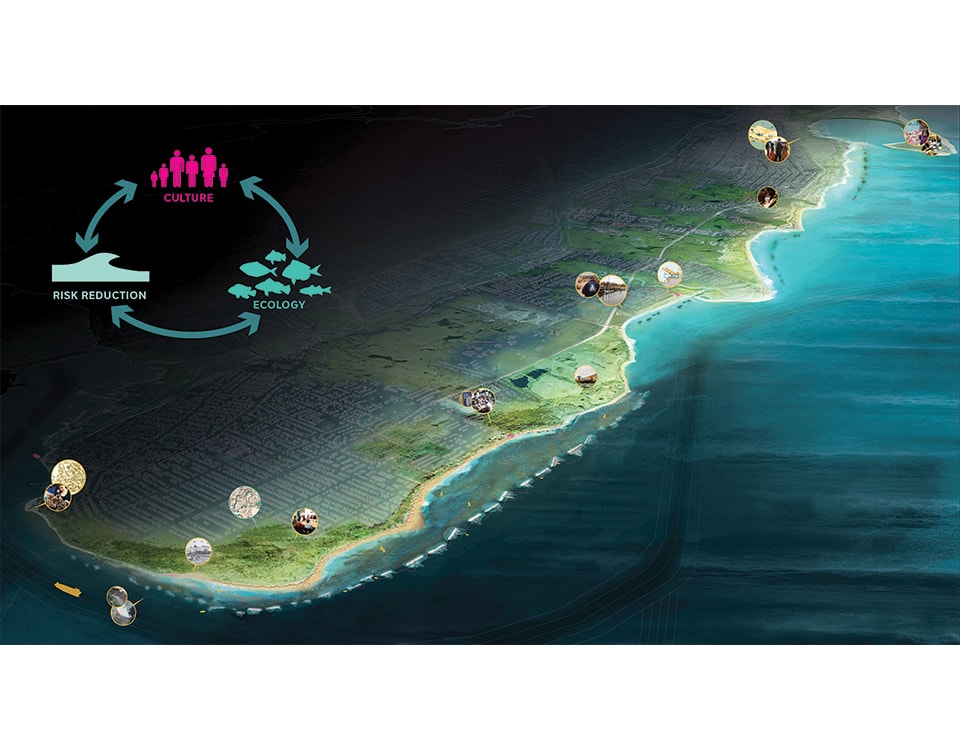
Project Description: Living in the Mississippi River Delta requires constant awareness of the forces of water, with multiple lines of defense to protect against high water in the Mississippi River, hurricanes approaching from the Gulf of Mexico, and intense rainfall inherent to the sub-tropical climate. The federal levees and floodwalls at the city’s perimeter protect human settlement from high river waters and hurricane storm surges. Within the levees, complex systems of canals, pipes, and pumps protect against flooding caused by rainfall. However, these systems are inadequate to the challenges posed by a changing urban landscape and climate and are the primary cause of subsidence in the region. With these concerns in mind in the aftermath of Hurricane Katrina, Waggonner & Ball saw an opportunity for New Orleans to reinvent itself as a safe, resilient, economically vibrant city that embraces its life-blood: water. This water management concept, Living With Water, is paradigm shift from a drain-pipe-pump mentality toward a system that values water as an asset. Explored through the Dutch Dialogues workshops and developed in the Greater New Orleans Urban Water Plan, the first large-scale Living With Water projects will soon be implemented through the City’s winning National Disaster Resilience Competition entry for the Gentilly Resilience District.

Initiated in 2006 and facilitated by the Royal Netherlands Embassy in Washington DC, Waggonner & Ball reached out to a multi-disciplinary array of Dutch and American organizations to examine methods for improving the design of urban water in the greater New Orleans area. Cosponsored with the Dutch Embassy and the American Planning Association, the three Dutch Dialogues workshops engendered a knowledge exchange between Dutch and American planners and urban designers, architects and engineers, and soils and hydrology experts as well as agencies and universities. This process not only explored the potential to transform land use by focusing first on water, but also established an international network of water management experts whose involvement continues beyond the workshops and Louisiana.

Development of principles established in the Dutch Dialogues continued when, in 2011-2013, the State of Louisiana’s Office of Community Development funded the development of the Greater New Orleans Urban Water Plan. This science and design-based process for creating a resilient and sustainable New Orleans region generated an unprecedented exchange among industry, government, economic development, and non-profit leaders. The plan focuses on water within the existing levee system – primarily stormwater, surface waters, and groundwater – offering a new vision for managing these resources while also addressing pluvial flooding, subsidence, and the misuse of regional water resources. It outlines principles for water management, regional planning, and urban design that are specific to place and developed out of a process that considers local soils, water and biodiversity; existing infrastructure networks; and the city’s distinct urban fabric.

The Urban Water Plan proposes a new investment model for public works wherein spending on streets, canals, pump stations, and stormwater detention basins enhances public spaces and yields opportunities for economic growth and development. Proposed retrofits strengthen existing water systems, make use of undervalued water assets, enhance key corridors, and broaden the hurricane protection concept of “multiple lines of defense” to incorporate urban water management. The five core principles of Living With Water are:

  1. Slowing and storing stormwater
  2. Circulating and recharging surface waters and groundwater
  3. Building with nature
  4. Designing for adaptation
  5. Working together

The plan is a living document created to guide long-range planning and investments for the next fifty years. Because water knows no boundaries, the plan calls for implementation at a range of scales and across political lines. The Greater New Orleans Urban Water Plan is publically available for download at livingwithwater.com.


Project Credits

DD1 Workshop Directors: Waggonner & Ball, Royal Netherlands Embassy, American Planning Association

DD1 Workshop Participants: (Dutch) Arcadis; Royal Haskoning DHV; City of Rotterdam; Netherlands Ministry of Environment, Spatial Planning and Housing; Netherlands Ministry of Infrastructure and the Environment; Netherlands Ministry for Transport, Public Work and Water Management; Rijnland Water Board; Delft University of Technology

(American) America’s Wetland Foundation; Center for Planning Excellence; CH2M; Conciously Rebuilding; CRCL; Fertel Foundation; Flood Protection Alliance; Laborde Marine; Port of New Orleans; SELA Flood Protection Authority; Wayne Troyer Architects; U.S. Army Corps of Engineers; State of Louisiana, Senator Landrieu’s Office; Louisiana Department of Transportation & Development; Louisiana Economic Development; Louisiana Coastal Protection and Restoration Authority; Louisiana Recovery Administration; Jefferson Parish; Plaquemines Parish; St. Bernard Parish; New Orleans Office of Recovery and Development Administration; New Orleans Regional Planning Commission; New Orleans City Planning Commission; New Orleans Sewerage and Water Board; Louisiana State University; Tulane University; Washington University in St. Louis

DD2 Workshop Directors: Waggonner & Ball, Royal Netherlands Embassy, American Planning Association

DD2 Workshop Participants: (Dutch) Arcadis; Bosch Slabbers; Deltares; DHV; ds+V; ; Robbert de Koning Landscape Architects; City of Amsterdam; City of Rotterdam; Netherlands Ministry for Transport, Public Work and Water Management; Netherlands Ministry of Environment, Spatial Planning and Housing; NIROV; Province of South Holland; Delft University of Technology; University of Wageningen

(American) Audubon Engineers; Center for Urban and Environmental Solutions; DMJM/Harris; Goody Clancy; Manning Architects; Schrenk & Peterson; Spackman Mossop and Michaels; Villavaso & Associates; Wallace Roberts Todd; Greater New Orleans Community Data Center; City of Fort Worth; Louisiana State University; University of New Orleans; Tulane University; University of Virginia; Washington University in St. Louis

DD3 Workshop Directors: Waggonner & Ball; Royal Netherlands Embassy; American Planning Association; Netherlands Water Partnership; United States Environmental Protection Agency; Tulane University

DD3 Workshop Participants: (Dutch) Arcadis; Bosch Slabbers; Deltares; H+N+S Landscape Architects; Palmbout Urban Landscapes; Royal Haskoning; City of Amsterdam; City of Rotterdam; Delft University of Technology; Wageningen University

(American / Canadian) AECOM; Avegno Bailey & Associates, Inc.; Cashio Cochran LLC; CDM Smith; Brown+Danos Landdesign, Inc.; Gil Kelley & Associates; Manning Architects; Shrenck & Peterson; Stull & Lee, Inc.; SWA Group; Tierra Resources; Urban Progress Design; Waldemar S. Nelson & Company, Inc.; Friends of Lafitte Corridor; New Orleans City Park; City of New Orleans; New Orleans Department of Public Works; New Orleans Redevelopment Authority; New Orleans Regional Planning Commission; Southeast Louisiana Flood Protection Authority; National Oceanic and Atmospheric Administration; Louisiana State University; University of Toronto; University of Virginia; Washington University in St. Louis; Yale University


Greater New Orleans Urban Water Plan

Design Team:
Waggonner & Ball, Project Lead, Coordination
Arcadis US; Engineering, System Cost Engineering
Bosch Slabbers Landscape + Urban Design; Landscape Architecture, Project Design
CDM Smith; Hydraulic Modeling, Outreach
City of Rotterdam; Water System Operations
Dana Brown & Associates; Landscape Architecture, Outreach
Deltares; Geohydrology, Implementation
FutureProof; Sustainability, Implementation
H+N+S Landscape Architects; Landscape Architecture, Urban Design
Manning Architects; Urban Design, Outreach
Palmbout Urban Landscapes; Landscape Urbanism
Robbert de Koning Landscape Architect; Landscape Architecture, Project Design
Royal Haskoning; Hydrology, Water System Analysis
Tulane University; Jurisdictional Context, Implementation
Washington University in St. Louis; Project Design

Senior Advisors:
Dale Morris, Royal Netherlands Embassy
Paul Farmer, American Planning Association
Piet Dircke, Arcadis NL

Advisors:
Kristina Hill, University of California Berkley
Bry Sarté, Sherwood Design Engineers
Jane Wolff, University of Toronto
Han Meyer, Delft University of Technology
Ton Schaap, City of Amsterdam
Steven Slabbers, Bosch Slabbers Landscape + Urban Design
Lodewijk van Nieuwenhuijze, H+N+S Landscape Architects
John Klingman; Tulane University

Resource Team:
Bright Moments; Outreach
Dewberry; NFIP Consulting, Risk Assessment
Eustis Engineering; Geotechnical and Hydrogeological Data
GCR; Economic Benefit Analysis
LSU Coastal Sustainability Studio; Visualization Tools
Waldemar S. Nelson and Company, Inc.; Project Cost Estimating


Hydrofutures

Project: Hydrofutures
Location: Lower Connecticut River, USA
Designer: Swarnabh Ghosh
Year: 2013
Program: Yale School of Architecture
Faculty Advisor: Greg Lynn with Brennan Buck
Website: http://www.swarnabhghosh.com/Hydrofutures

Project Description: This project explores the legacy and the future of hydroelectric power in the Northeastern United States. By tracing the history of dam construction in the US, this project calls into question the role of dams in the 21st century and proposes an alternative to the thousands of inefficient and obsolete dams that disrupt American river systems. By studying the potential application of inflatables in flood control and power generation, this project proposes a form of hydroelectric power generation that utilizes inflatables and extant hydrokinetic turbine technology to decentralize electricity production in river systems while producing an entirely new type of riverine urbanism.

This soft water-based infrastructure can be distributed along river systems in various configurations to perform a variety of functions in addition to power generation. Using a system of inflatable tubes, rings and pads held together by ‘clips’ in the form of barges, the project is rapidly deployable and utilizes hydrokinetic turbines to generate electricity from the kinetic energy of flowing water.

Over the last decade, governmental agencies like the Army Corps of Engineers as well as turbine manufacturers like Verdant and General Electric have shown increasing interest in the potential of hydrokinetic energy as a viable alternative to conventional hydroelectric power generation. A 2012 study by the Electric Power Research Institute posits that the ‘theoretically available’ hydrokinetic resource for the continental US is in excess of 1380 TWh/Yr [1]. Current annual hydroelectric output in the United States is in the region of 280 TWh.

While the technology to extract kinetic energy exists and continues to evolve, this project inserts/embeds a spatial variable to the mix. By embedding civic program in these otherwise submerged and invisible machines, the project performs like a radically expandable and configurable energy landscape, recasting infrastructure in a civic and cultural role. Moreover, by decentralizing power generation and dispersing it at the scale of a region, this form of energy production is more responsive and provides opportunities for multiple scales and timeframes of application without disrupting fragile fluvial ecologies.

The early stages involved the study of inflatables and their potential application in flood control and power generation. With the help of dynamic physics engines, studies were conducted to control and design the deflation and inflation of elastic objects. The second stage of the project involved the design of the spatial components of the hydrokinetic system and the analysis of efficiencies of possible configurations with the help of computational fluid dynamics. The components of the system consist of hydrokinetic turbines (~45 MW) suspended from barge ‘clips’ which, in turn hold together the programmatic rings and pads. The inflatable ‘tubes’ which control the flow of water are held together by the rings and an underwater system of cable ties. Grouping the system in different configurations such as dispersed arrays or tight packs or (dispersed array vs. tightly packed) could potentially modulate the flow velocity of river water to (i) help increase the productivity of the turbines as well as (ii) mitigate flooding.

The scalability and adaptability of this approach allows for careful scrutiny of the inherent geographical and political implications of hydropower production. Hydrofutures asserts the possibility of large-scale infrastructure as a productive civic undertaking by inserting a series of spatial variables into a predominantly technological mix. In this manner, it attempts to redefine the relationship between contemporary society and the increasingly vast infrastructural landscapes it inhabits.


Notes:

[1] For more, see “Assessment and Mapping of Riverine Hydrokinetic Resource in the Continental United States”, EPRI, Palo Alto, CA:2012. The EPRI is a non-profit organization based in Palo Alto, CA funded by the electrical utility industry of the United States.


Sea Quilt

Project: Sea Quilt
Location: Seattle, Washington
Firm: Rikako Wakabayashi and Sen Ando
Year: 2012
Competition: Third Place – Rethink Reuse: Transforming Seattle’s 520 Floating Bridge International Design Ideas Competition
Website: http://www.rethinkreuse.org

Project Description: To those living in the Northwest, Seattle gains its unique character by being a community of small cities, towns and neighborhoods. This collective exists as an aggregate of idiosyncratic neighborhoods without ever losing its Seattle-ness. This project examines questions of character, program, mobility and history in the reuse of the decommissioned 520 Floating Bridge as part of the Rethink Reuse 2012 International Ideas Design Competition. The 520 floating bridge will be decommissioned in 2014 due to high maintenance costs, damage, and the need for expanded vehicular capacity. We believe that not only should the bridge structure be reused, but that the future use of the 520 Bridge should involve the entire Seattle community and that the pontoons’ inherent aquatic mobility will help connect these geographically disparate neighborhoods.

The 33 massive floating pontoons offer a unique opportunity to the Puget Sound. Each pontoon can drift and migrate to each of Seattle’s widespread neighborhoods, providing a generous amount of new public program for each. Neighborhoods in need of theaters will get floating amphitheaters. Coastlines without public space will get beaches and playgrounds, and so forth. We view adaptive re-use as an opportunity to provide a reciprocal relationship with Seattle’s communities—the pontoons provide new program, the locals use it and adapt the spaces to their own individual needs.

Pontoons are very flexible. Not only are they buoyant and mobile, but their regularized dimensions make re-organizing and assembling easy. The pontoons can dock to each other to create bigger spaces as needed. If there is a large event, two pontoons can come together to create a new open ground for that purpose.

We propose that the pontoons not only migrate out to Seattle communities, but also provide an opportunity for them to come together as one. During this time, Seattle can unite as a diverse but singular entity. By merging all of the pontoons together at a central location in Lake Union, we’re essentially merging all of the communities into a floating quilt.

See the full competition board here.


Infrasurface

Project: Infrasurface
Location: Keelung River, Taipei, Taiwan
Designer: Jonathan Reyes
Program: Yale University School of Architecture
Faculty Advisor: Heneghan-Peng Architects

Project Description: A city situated at the bottom of a flood basin, Taipei’s urban dynamics are direct consequences of infrastructural systems and urban forms that enable to city to function throughout regular inundation and inclement weather.  Typically, flood-resistant infrastructure employs strategies of resistance, most evident in the enormous floodwalls along .  Unsurprisingly, the urban spaces adjacent to these walls are frequently devoid of activity beyond parking and storage.

This design for a research campus near the meeting point of the Damsui and Keelung Rivers adapts conventional urban logics to produce an integrated system of infrastructure and architecture.  Through the manipulation of the floodwall on the south bank of the Keelung, the resultant terrain simultaneously resists and embraces floodwater inundation to establish two distinct programmatic functions.  By pinching and stretching this wall into alternating positive and negative incursions, or inlets, into the site, the formerly vertical flood barrier becomes a compound, contoured, and traversable surface.

Negative depressions serve as inlets for floodwater retention, appropriately contoured to accommodate external laboratories, wet agricultural fields, recreational landscapes and other outdoor programming for the campus.

Positive extrusions become building masses and inlets for the infiltration of the city into the site and campus.  This topographic infrastructure serves as a series urban frames that protect the zones of infiltration from inundation while cultivating Taipei’s informal urban character within them.A site-wide contour logic serves as a physical demarcation of flood levels and event boundaries. The contours and the density of spacing between them establish a parametric system of slopes and modules employed across the campus.

A site-wide contour logic serves as a physical demarcation of flood levels and event boundaries. The contours and the density of spacing between them establish a parametric system of slopes and modules employed across the campus.


Carbon T.A.P.

Project: Carbon T.A.P. (Tunnel Algae Park)
Location: Philadelphia, PA
Firm: PORT Urbanism
Year: 2009
Competition: Winning Entry, UCLA/CityLAB WPA 2.0 Design Competition
Website: http://porturbanism.com/work/carbon-t-a-p/

Project Description:  As Federal, state and local governments undertake consideration of large-scale investments in the renovation and replacement of urban infrastructures, we see a unique opportunity to reconsider the role of these systemic networks and their effect on our contemporary urban landscapes.

In the scenario outlined herein, a new type of ‘green’ infrastructure is deployed at urban locations comprising concentrated sources of CO2 production. This new infrastructure utilizes a proprietary system of industrial scale algal agriculture to sequester and consume greenhouse gas emissions in order to limit their introduction into the atmosphere, while simultaneously creating a new economic resource through the production of oxygen, biofuels, bioplastics, nutraceuticals and/or agricultural feeds. In the scenario shown above, this new infrastructure manifests itself as a series of pier-like armatures linked to the ventilation system for the Brooklyn-Battery tunnel.

What is unique about this proposition is not just the introduction of large-scale urban green infrastructure, but rather the use of infrastructural armatures to create an exceptional public realm amenity for the city. Rather than considering urban infrastructures as a necessary evil to be hidden or mitigated, we view the renovation and re-imagination of these systems as opportunities to create new forms of civic and social domain that have the capacity to positively transform the American urban landscape.

Our proposal for a new infrastructural typology is one part climate action; one part agricultural production; one part ecological preserve; one part public realm; and one part economic catalyst represents what should be the aspiration for all newly deployed urban infrastructures—the ability to fundamentally improve the economic and social quality of a city, as well as the associated lives of its current and future residents.


National HEDGE

Project: National HEDGE
Location: National electricity grid, United Kingdom
Designer: PORT Urbanism
Year: 2011
Website: http://porturbanism.com/work/national-hedge/

Project Description: Infrastructure that performs a single operation reflects a nineteenth-century approach to towards urbanization and misses the latent opportunities for synthesis and hybridization embedded within these already established network corridors. This project is a response to a call to redesign the traditional British electricity pylon. Instead of designing a new engineering object, we approached this opportunity as an occasion to fundamentally re-conceive the broader urbanistic role of the entire electricity grid across the British landscape, bundling ecological connectivity and habitat expansion with the necessary control and management of an elemental urban infrastructure system.

Our proposal imagines the iconic British hedgerow as a flexible, nationwide ecological-infrastructure regime. Deployed as a continuous, horizontal-thickened hedge complex in the right-of-ways and easements of existing and future electricity grid corridors, National HEDGE represents an integrated, progressive reinterpretation of a culturally significant system of territorialization capable of supporting substantial ecological expansion as well as offering a contemporary and iconic image of infrastructural integration into the landscape of the UK.

The intent is two-fold: First, is to integrate the electricity grid into the varied landscapes of the UK, not through formal exuberance or aesthetic mitigation, but through the compositing of seemingly oppositional landscape systems to create new, hybrid forms of urbanization. Second, is to reestablish a nationwide ecological regime that stitches together the fragmented natural habitats of the UK countryside by linking existing infrastructure easements and right of ways to the country’s most significant areas of natural preserve – the UK’s 15 National Parks.

British hedgerows represent a range of vernacular and ornamental variations – each reflecting distinct cultural, topographic, climatic and ecological conditions. We do not conceive of the National HEDGE as a monolithic entity. Rather, it is composed as a highly customizable ecological infrastructure that is capable of local calibration while maintaining robust performance across the network.

Hedges comprising native vegetation are recognized as a priority habitat for conservation action by the UK Biodiversity Action Plan (BAP). Representing a mix of woodland, scrub and grassland, hedgerows can accommodate a wide range of species and serve to facilitate migration at a landscape scale. Twenty-one BAP priority bird species are associated with hedgerows – thirteen of which reside primarily within hedge habitats.

The hedge complex will also serve to reduce the loss of agricultural soil from wind scouring and erosion. Additionally, hedgerows improve regional water quality by filtering fertilizers and pesticides found in agricultural run-off.

Given the scale and expanse of the national electricity network, the quantity of biomass that would constitute the National HEDGE complex is significant. Presently the UK has approximately 814,159km hedgerow coverage and 20,920km (13,000 mi) of electricity grid. The National HEDGE could constitute as much as a 51.4% increase in total hedgerow length with approximately 418,400 km of new hedgerow across the countryside. Conservative estimates suggest 600-800kg of CO2 sequestered within 1km of hedgerow per year for up to 20 years. Thus, the National HEDGE could reduce atmospheric carbon dioxide by anywhere from 251-million kg to 335-million kg per year – roughly equivalent to 45-59% of the total CO2 emitted by the UK and Crown dependencies in 2009.

In addition, the harvested material collected from the management of the hedge represents a substantial, continuously available source of woody biomass that could be converted into cellulosic ethanol and methanol without adversely impacting market pricing of other commodities.

Ultimately, the benefits of a hedgerow network of this scale are both significant and numerous: cultural heritage; landscape character and texture; control and maintenance of the grid corridor; employment generation through required management and maintenance; continuous source of biomass; carbon and greenhouse gas sequestration; wildlife habitat and refuge; soil and water management; support of UK Biodiversity Action Plan; and the creation of an iconic, integrated urban landscape system that can stand the test of time much like the electricity pylon itself.

This project was an entry in the Pylon Design Competition, hosted in 2011 by the Royal Institute of British Architects (RIBA) for the Department of Energy and Climate Change (DECC) and the National Grid.

Living Breakwaters

Project: Living Breakwaters
Location: Staten Island, NY
Firm: SCAPE / Landscape Architecture
Year: 2013
Competition: Rebuild by Design
Website: Rebuild by Design – Living Breakwaters 

Project Description: The Living Breakwaters concept design was developed by the SCAPE / Landscape Architecture team for the U.S. Department of Housing and Urban Development’s Rebuild by Design Initiative, and was one of six winning proposals in the global competition. The proposal was awarded to New York State and will be implemented by the Governor’s Office of Storm Recovery with $60 million of CDBG-DR funding allocated specifically for this project. (Read more here and here).

The Living Breakwaters project reduces risk, revives ecologies, and connects educators to the shoreline, inspiring a new generation of harbor stewards and a more resilient region over time. Staten Island sits at the mouth of the New York Bight, and is vulnerable to wave action and erosion. Rather than create a wall between people and water, the project embraces the water, increases awareness of risk, and steps down that risk with a necklace of breakwaters to buffer against wave damage, flooding and erosion.

The SCAPE team designed “reef street” micro-pockets of habitat complexity to host finfish, shellfish, and lobsters, and also modeled the breakwater system at a macro scale to understand how and where they can most effectively protect communities. This living infrastructure will be paired with social resiliency frameworks in adjacent neighborhoods. Through the Billion Oyster Project and an associated network of programmed water hubs, local schools will be empowered with science, recreation, education, and access.

The layered approach is especially suited to Staten Island’s south shore, but it is also replicable in other waterfront communities faced with the similar duality of risk and opportunity presented by their connection to the water. Tottenville, the site of our proposed Phase One pilot, was once known as “the Town the Oyster Built.” During Sandy, lives were tragically lost, and homes and parks were severely damaged. Moving forward, we can foster a vibrant water-based culture, invest in our students, shoreline ecologies and economies, and Tottenville can claim the mantle as the Town the reef re-built.

Project Video: 

Living Breakwaters from Rebuild by Design on Vimeo.

The SCAPE Team:
SCAPE Landscape Architecture
Parsons Brinckerhoff
Dr. Philip Orton / Stevens Institute of Technology
Ocean and Coastal Consultants
SeArc Ecological Marine Consulting
The New York Harbor School
LOT-EK
MTWTF
Paul Greenberg

Queens Plaza

Project: Queens Plaza
Location: Long Island City, NY
Firm: Margie Ruddick
Year: 2003
Firm website: margieruddick.com

Project Description:  Queens Plaza is the gateway to Long Island City from Manhattan. Spanning eight city blocks, the completed project enhances a tangle of 14 lanes of traffic, two elevated subway lines, two bridges, and a parking lot. Through road realignment, the project improved vehicular circulation, created alternative transportation corridors, and opened space for a primary park area.

As one of two pilot projects for New York City’s High Performance Infrastructure Guidelines, Queens Plaza utilizes a constructed wetland and subsurface filtration systems to prevent over 20.2 million gallons of stormwater from entering the city’s combined sewer system, reduces ambient noise pollution from elevated trains passing through Queens Plaza by 23%, and has increased surrounding property values by 37% (during a period when NYC Metro property values increased by 8%). On an average summer day, Queens Plaza attracts 125 visitors to a site once described colloquially as the ‘Boulevard of Death’.

Designed in collaboration with the artist Michael Singer, the project employs interlocking and modular permeable pavers that serve as firm walking surfaces and that transport surface runoff to infiltration areas. This strategy incorporates high albedo asphalt aggregates, recycled asphalt, and reused demolition materials for a sub-base in order to reduce ambient air temperatures and watering requirements for the project’s 489 native trees and grasses.

Rather than removing or masking the surrounding infrastructural elements, the project incorporates flexible stainless steel mesh to highlight the complex and irregular volumes created by the undergirding of the elevated rails. Through creative lighting, these spaces are turned into a lantern-like serial installation suspended between the vehicular traffic above and pedestrian traffic below. These structures provide the tracks with legibility and highlight them as a wayfinding beacon at the interaction of Jackson Avenue and Queens Plaza.

Rejecting the notion of passive ‘greening,’ Queens Plaza reactivates an underutilized space and the surrounding urban fabric created by unplanned infrastructural layering. Satisfying performative criteria and providing social and recreational benefits, the project is a robust precedent of what landscape can achieve in a challenging urban context.

Project Team:

Margie Ruddick – Design Lead
Marpillero Pollak Architects – Architecture and Urban Design
Michael Singer Studio – Public Art
WRT – Landscape Architecture
Leni Schwendinger Light Projects – Lighting Design
Langan Engineering – Civil Engineering


Featured in Scenario 3: Rethinking Infrastructure