Both physically and spiritually, cities need forests. As the etymology of the term ‘foris’ – meaning ‘outside’ – denotes, the forest was positioned conceptually and spatially as the city’s counterpart [1]. However, as landscape architects gain increasing influence over urban environments the forest is now entering the city and being interwoven with it.
Schools of thought such as Landscape Urbanism, Green Urbanism and Ecological Urbanism take the forest as an ideal model for the city. The analogy points to a future city that works as a mature ecosystem, a city that converts its linear and wasteful systems into closed metabolic loops to reach a relatively stable, resilient and symbiotic state. In response, New Urbanists tell us this future city-as-forest is neither possible nor desirable [2]. Where green space is gratuitous and works to dissipate density, they have a point, but Andres Duany’s insistence on organizing the city along a transect that has culture at one end and nature at the other arrests urban evolution in the 19th century.
Important as they are for deciding the degree to which the future form and function of our cities evolve, these debates are somewhat out of sync with the actual scale and reach of the contemporary city. If we accept that ‘the city’ is now a continuous system of global exploitation and not merely the morphology of various residential and commercial densities, then any discussion of the ‘urban forest’ means that we should also scale up our thinking and discuss the ‘global city’ and its relationship to the ‘global forest’.
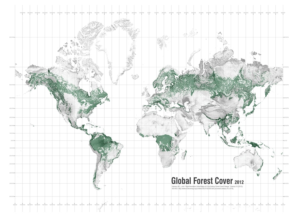
Figure 1. Global Forest Cover
The Global Forest
The Earth Policy Institute (2012) estimates that approximately 31% of the earth’s terrestrial area (four billion hectares) is covered with forest [3]. However, despite increased awareness of the benefits of forests in respect of carbon sequestration, ecosystem services and provision of habitat, deforestation rates remain disturbingly high [4]. Some deforestation is attributable to ‘natural’ causes, but most of it is caused by human activity and much of that activity occurs in nations bedeviled by poverty and corruption where tropical forests are central to any hope of global climate regulation and biodiversity preservation. Regional increases in forest cover have typically occurred in places, such as China, where extreme poverty has been alleviated. It was for this reason that at Copenhagen in 2009 US Secretary of State Hilary Clinton offered impoverished nations up to $100 billion annually to reforest their denuded landscapes [5]. But that was Copenhagen.
A recent report by the United Nations Environment Programme and the World Conservation Monitoring Centre states that only 7.7% of the world’s forests are currently protected within strict conservation categories [6]. These categories are: 1) Strict Nature Reserves, and Wilderness Areas, 2) National Parks, 3) National Monuments, and 4) Habitat and Species Management Areas. Sixty-seven per cent of the 742 ecoregions with some forest cover have less than 10% of their forest area conserved [7]. In addition to these four conservation categories, the International Union for the Conservation of Nature (IUCN), Conservation International (CI), and the United Nations (UN) recognize two additional categories, so-called ‘Protected Landscapes (modified landscapes of cultural, ecological and scenic value)’ and ‘Protected Areas with Sustainable Use of Natural Resources’. If these areas are taken into account, then 13.5% of the world’s forests are officially ‘protected’ [8].
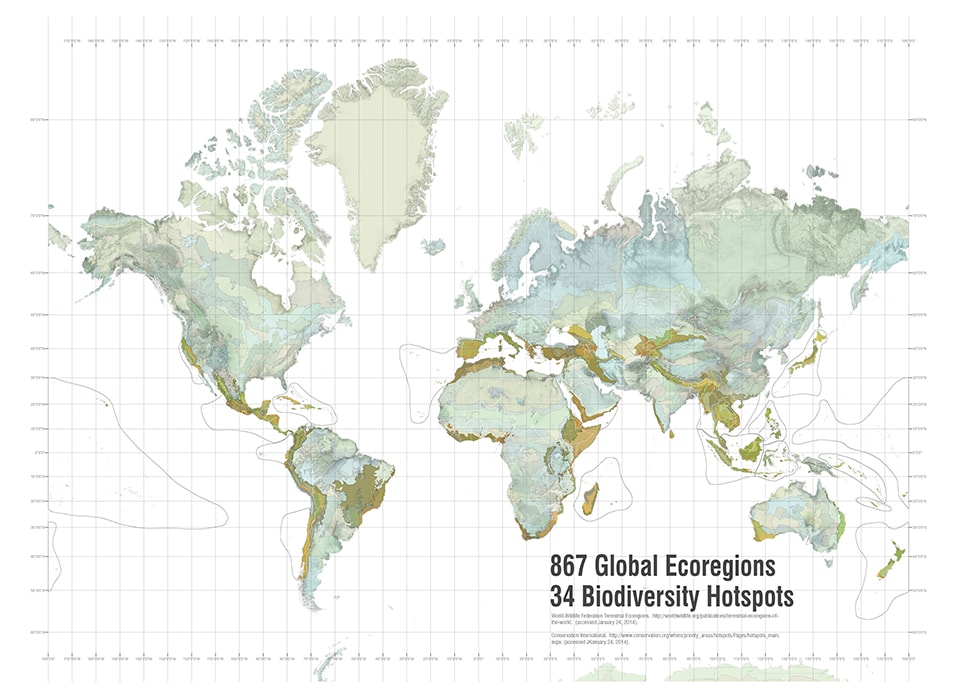
When considering these quantities from a global conservation perspective, it is important to also take into account the degree to which the protected areas include a representative sample of global biodiversity [9]. Presently, protected lands for all types of habitat are unevenly distributed across 235 countries in 160,000 sites [10]. Taken as a whole, these sites constitute 13% of the world’s remaining habitat and represent little more than half of earth’s 867 ecoregions [11].
Figure 2. Global Protected Areas (IUCN Categories 1–4)
The designation and management practices of protected areas are at the discretion of individual nations. In their current fragmented and diminutive state the world’s 160,000 protected areas will neither conserve global biodiversity nor mitigate climate change, the primary ecosystem functions we now look to our forests to provide [12]. As the concept of pristine nature becomes increasingly untenable, new forms of protected landscape are necessary.
The world’s most substantial effort to increase protected areas is enshrined in the United Nation’s 1992 Convention on Biological Diversity (CBD) to which 192 nations (and the European Union) are parties [13]. Originally the CBD set a commitment to conserving ‘[a]t least 10 per cent of each of the world’s ecological regions’ [14]. At the 2010 conference of parties in Nagoya a new set of CBD targets, known as the Aichi Targets, were established. The Aichi Targets comprise 20 policy statements agreed by CBD parties to achieve the strategic goals of halting biodiversity loss by, among other things, safeguarding ecosystems, species and genetic diversity. Aichi Target 11 states that “by 2020, at least 17% of terrestrial and inland water areas and 10% of coastal and marine areas, especially areas of particular importance for biodiversity and ecosystem services, are [to be] conserved through effectively and equitably managed, ecologically representative and well-connected systems of protected areas” [15]. With regard to forests, the convention calls for the effective conservation of “at least 10% of each of the world’s forest types” by 2010 [16].
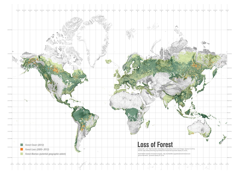
Figure 3. Loss of Forest Between 2000 and 2014 (orange)
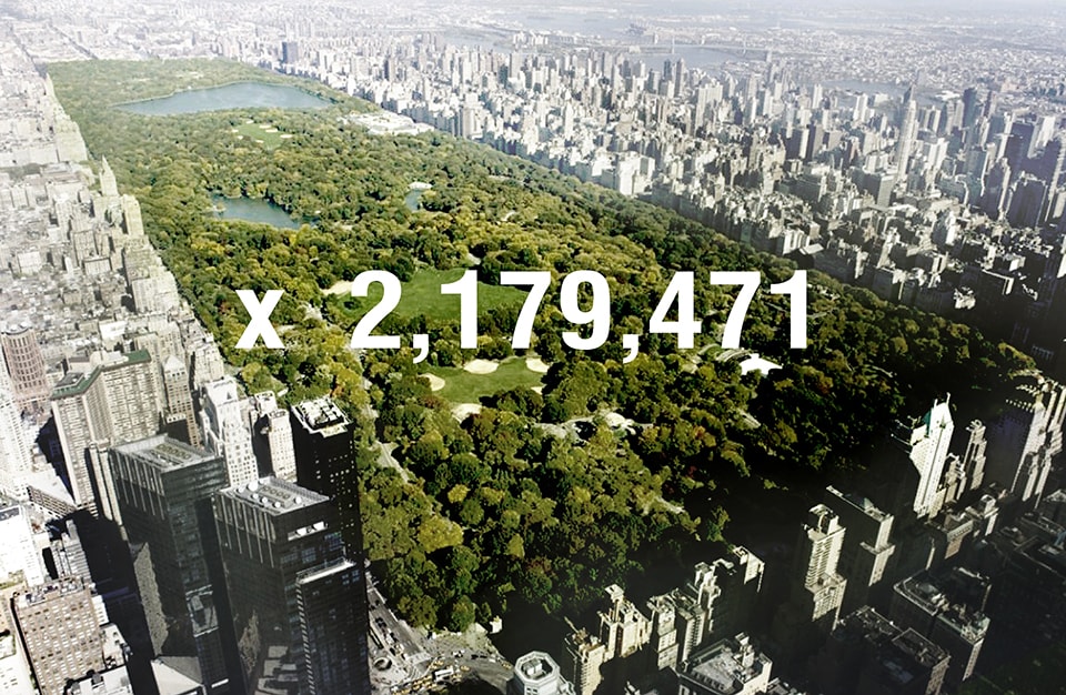
Given that currently 13% of the world’s terrestrial area is presently under some form of conservation protection, the CBD commitment only requires that another 4% be secured globally by 2020. Four percent may seem modest, but this depends on how you look at it. For example, 4% of the earth’s terrestrial surface is 5,932,000 km2: the equivalent of 1,739,589 Central Parks.
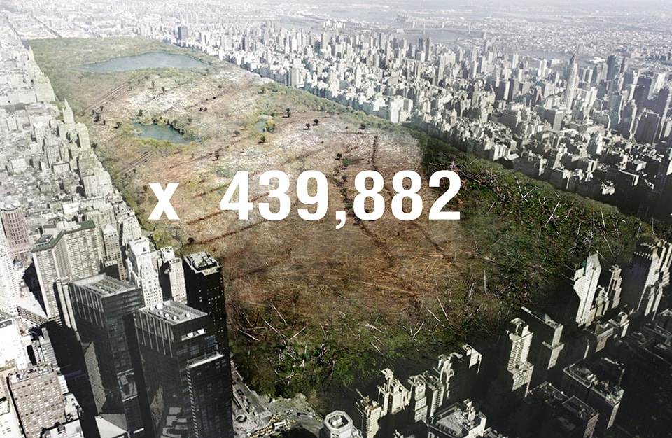
Secondly, the 4% must also be seen against the rate of ongoing habitat loss. A recent report in Science [17] concluded that between 2000 and 2012 the world lost 2.3 million square kilometers of forest and only added 800,000: a net loss of 1.5 million (or 439,882 Central Parks). Taking this loss into account, the global effort to reach Aichi Target 11 would require that the equivalent of 2,179,471 Central Parks be secured as habitat by 2020. This is nothing less than the largest landscape architectural project in history, and yet there is a conspicuous absence of design intelligence being applied to this problem.
Figure 4. The number of Central Parks required to meet Aichi Target #11 – 17% of global habitat legally secured and or reconstructed as protected areas between now and 2020
Figure 5. Between 2000 and 2012, the world lost 2.3 million square kilometers of forest and only added 80 million: a net loss of 1.5 million (or 439,882 Central Parks)
The Conservation Landscape
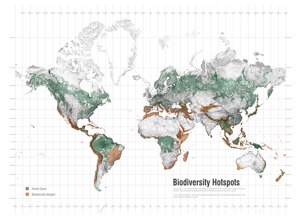
The first important phrase in the text of Aichi Target 11 is that the 17% protected global habitat should be ecologically representative. According to the CBD, this requires nations to ensure that “protected area systems…contain adequate samples of the full range of existing ecosystems and ecological processes, including at least 10% of each ecoregion within the country.” [18] In some cases, particularly in the 34 designated biodiversity hotspots where the habitats of close to half the world’s plant and animal species are critically depleted [19], it is not possible to protect what no longer exists. In such cases Aichi Target 15 asks CBD parties to restore at least 15% of their degraded ecosystems.
Figure 6. Global Ecoregions
In order to better understand the global situation, we have taken the 17% global target and mapped the results of its application to each of the 374 ecoregions that constitute the world’s biodiversity hotspots [20]. In almost all cases, there is a significant shortfall between habitat that is currently under protection (according to IUCN categories 1–6) and what would be required to meet the target. Reaching the global target of an extra 4% protected habitat would not be such an issue if it were achieved through the designation of large areas in parts of the world where it was economically inconsequential, but when Aichi Target 11 is applied at the level of individual eco-regions it implies, in many cases, massive restoration projects.
Figure 7. Global Biodiversity Hotspots x 34
The second crucial expression in Aichi Target 11 is that protected areas (either extant or created) must be comprised of well-connected systems. This means nations need to invest in the creation of greenways that connect fragmented remnant habitat with patches of new habitat across all the ecoregions comprising their territory. In addition to providing a range of ancillary ecosystem services and cultural benefits, the primary rationale for such connected systems is to provide a means for plant and animal species to migrate and adapt to climate change over time. Because these connections need to cater for different species and because they will typically cross a range of existing incompatible land uses and boundaries (including national or subnational jurisdictional boundaries), they become particularly challenging design problems.
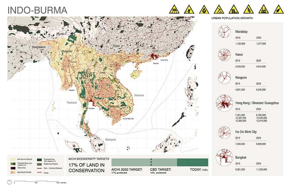
Figure 8. The Indo-Burma Hotspot, an example of mapping undertaken at the University of Pennsylvania. The bar graph shows the shortfall between the current amount of protected habitat (IUCN categories I1–4) and the 17% Aichi Target. The ‘fact sheet’ includes a list of active threats to habitat and population projections for major urban growth centers in the hotspot.
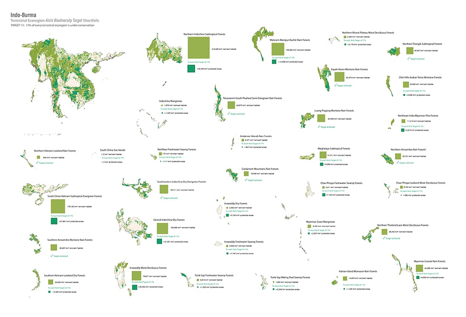
Figure 9. An example of mapping the ecoregions of one hotspot, in this case the Indo-Burma hotspot. The two tones of green adjacent to each ecoregion show the amount of remnant habitat in the ecoregion (IUCN categories I-VI) and the shortfall between this and the 17% Aichi Target.
While much important scientific work is being done to document the conservation value of hotspots and identify imminent threats to their unique biodiversity, little attention has been applied to specific spatial planning of green infrastructure networks that would meet the targets [21]. According to the CBD, parties should all have ‘National Biodiversity Strategy and Action Plans’ (NBSAPs) in place by 2015. The CBD reports that, to date, 178 of the 192 nations party to the Convention have NBSAPs, but our (desktop) research found that only 12 of the 104 nations in the recognized biodiversity hotspots have any semblance of spatial plans that accurately designate land for protection and/or restoration [22].
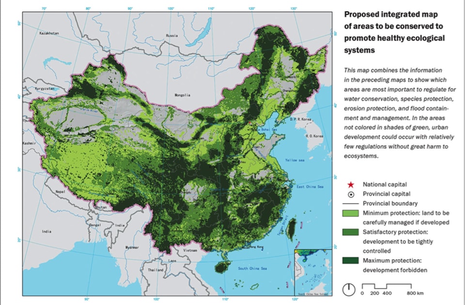
Where spatial planning of large-scale habitat reconstruction and preservation does exist, it is typically conveyed in the form of maps with thick green lines drawn over vast territories with evidently little regard for existing land uses and ordinances. For example, in China, landscape architect Kongjian Yu’s unofficial ‘National Ecological Security Pattern Plan’ draws habitat reconnections on a vast scale according to the criteria of securing biodiversity, reducing desertification, and protecting water quality [23]. Admirable as this vision is, Yu does not shift scale to explain or illustrate how the appropriation of this extensive territory can be reconciled with existing landscape conditions and communities, or how any consequential loss of agricultural land would be offset.
Figure 10. A National Ecological Security Plan for China by Turenscape. Image courtesy Kongjian Yu
A similar example is the Pan European Ecological Network (PEEN). Emerging out of the European tradition of greenbelts and hedgerows, the PEEN is a trans-European network of ecological corridors and patches comprising 17 sub-networks. Reserving land for habitat in Europe is made possible by its largely post-industrial economy and agricultural surplus, but even so, Jongman et al. have reported considerable difficulty in achieving the requisite connectivity at both sub-regional and transnational scales [24]. The difficulty of achieving ecological networks in China (where centralized government makes almost anything possible) and in Europe (where there is relative wealth and political unification) does not bode well for more fractious territories. With their oft-heralded mandate of stewardship and interdisciplinary aptitude, landscape architects would seem well placed to lead teams to help nations meet the CBD targets by developing national plans for landscape preservation and restoration which are both “ecologically representative” and “well connected”.
In addition to preserving global biodiversity and protecting the ability of landscapes to function sustainably, the protection and regeneration of forested land has serious climate change implications. Peter Ward, Professor of Biology and Earth and Space Sciences at the University of Washington (Seattle), notes that current rates of deforestation contribute 16% of global carbon emissions. He writes, “[g]lobally nothing will help reduce carbon emissions more than planting trees.” [25] Similarly, after reviewing a range of highly technical and unpredictable geo-engineering concepts for mitigating climate change, famed author of the Gaia Hypothesis James Lovelock also recommends we immediately lock up all remaining habitat and plant more trees. However, as Lovelock explains, global reforestation cannot merely take the form of homogeneous plantations: we need to recreate forests with ecological complexity in order to maintain resilience into the future [26]. Given the impossibility of the literal recreation of complex ecosystems, we are then in the business of creating what Richard Hobbs refers to as “novel ecosystems” on a scale commensurate with the global ecological crises of climate change, deforestation and habitat loss [27].
Conclusion
Global policy settings such as the Aichi Targets offer a clear basis from which nations can negotiate the process of securing, reconnecting and reinstating habitat. But top-down policy will have little, if any, impact in politically unstable and impoverished parts of the world unless it is translated into the cultural and ecological specificity of place. As the maverick biologist Dan Janzen insists, the real work of restoration (as he has proven so convincingly with his own 165,000-hectare ‘garden,’ Area de Conservacion Guanacaste, in Costa Rica) can only be guided by the details of the site, its ecology and its society [28]. Janzen says we need to move beyond the image of pure wilderness and cultivate large areas of new wildlands as if they were gardens, places which have “all the traits that we have long bestowed on a garden – care, planning, investment, zoning, insurance, fine tuning, research and premeditated harvest.” [29]
By the same token, if restorative and protective efforts are left to piecemeal localized initiatives with no overarching planning that sets guidelines and regulatory frameworks for broad-scale connectivity and long-term futures, then the results will be at best fragmentary and ultimately unable to form the resilient large-scale habitat networks needed in the face of climate change. Similarly, if restorative landscape initiatives are planned for in a manner that is unrelated to the more powerful processes of urbanization occurring worldwide, then they will be vulnerable to the deleterious impacts of development. The future of rural landscapes, where restorative measures are crucial to biodiversity, has to be understood as connected to the dynamics of urbanization. As studies by the Yale School of Forestry estimate, there will be approximately another 120 million square hectares of land subsumed into urban development globally by 2030, and much of it in the world’s biodiversity hotspots [30]. The integration of urban growth with restorative initiatives to meet the Aichi Targets is the scale of operation required if the global city is to create a truly symbiotic relationship with the global forest.
Without the global forest, there will be no global city.
Credits
Mapping research and graphic production by Claire Hoch and Matt Wiener
 Richard Weller is the Martin and Margy Meyerson Professor of Urbanism and Chair of Landscape Architecture at the University of Pennsylvania. Formerly he was Director of the Australian Urban Design Research Centre (AUDRC) and the design firm Room 4.1.3 known for the controversial National Museum of Australia. In addition to three books regarding his design and planning work, he has published over 70 papers on the intersection of ecology, art and design and given hundreds of public lectures around the world. Throughout his academic career he has received a consistent stream of international design competition awards at all scales of landscape architecture and urban design and was honored with an Australian National Teaching Award in 2012. Professor Weller’s current research concerns global conflict zones between rapid urbanization and biodiversity.
Tatum Hands is editor in chief of LA+ Interdisciplinary Journal of Landscape Architecture, produced by The University of Pennsylvania School of Design. Her current research involves evaluation of the legal and policy implications of landscape architectural scenario modelling in biodiversity hotspots. Before joining PennDesign, Tatum worked as a consultant to government in law and policy reform. She holds a degree in law and a Ph.D. in political science.
Notes

