Buzzwords such as “sustainability,” “green” and “eco” are now ubiquitous in our contemporary dialogue about landscape architecture and urban design. Many firms and practitioners freely use these terms when describing their built work. Very little measurable data has been collected about the performance of many of these green projects, leaving these claims unsupported. It is becoming essential however, that practitioners begin to quantify the performance of their work in order to make a stronger and more legitimate case for the benefits of sustainable landscape infrastructure in urban design projects.
Mithun, a multidisciplinary design firm integrating urban design, planning, architecture, landscape architecture and interior design, has long been committed to developing and implementing performance metrics in its projects. The practice is keenly focused on looking beyond the building and the site to the district or neighborhood scale. This essay will examine how the thinking and approach at Mithun has evolved towards the use of predevelopment baseline metrics and new tools for measuring the impacts of design projects on human and community health.

Overview of Lloyd Crossing Catalyst Project. Image © by Mithun
The Lloyd Crossing Sustainable Urban Design Plan
The Lloyd Crossing Sustainable Urban Design Plan created a vision for Portland, Oregon’s Lloyd District that could be both environmentally and financially sustainable. Begun in 2002, it predated the development of the Living Building Challenge, SITES or LEED for Neighborhood Development. The multidisciplinary design team led by Mithun, which included landscape architects Greenworks, was asked what it would mean to create a beyond “LEED Platinum” neighborhood. The client’s goals were to use the plan’s deep sustainability as a mechanism to help strengthen neighborhood identify within Portland, which would provide a model for development efforts throughout the rest of the city.
Since no neighborhood-scale rating systems were yet in place, the integrated design team first developed a set of predevelopment metrics – an environmental performance benchmark based on the “carrying capacity” of the 47 acre site prior to urbanization. The design and stakeholder team understood that an innovative district-scale approach would be required to achieve the seemingly contradictory goals of a fully developed urban site that met predevelopment metrics benchmarks. This approach was a powerful organizing force that allowed stakeholders to think beyond traditional limitations of property lines and existing urban systems.
The primary predevelopment metrics were organized around habitat, water, energy and carbon use. These baselines provided the framework for evaluating and understanding the systemic nature of the interconnected design strategies. They were also central to establishing the financial and governance frameworks for exploring new models of public/private partnerships to support the project goals for the year 2050.


Predevelopment baseline conditions and Lloyd Crossing 2050 proposal for habitat, water use, and energy. Image © by Mithun
Habitat
At Lloyd Crossing, the predevelopment habitat was a mixed conifer forest with 90% tree cover and broad diversity of wildlife species. The goal was to increase native tree cover to 25-30% of the site, create structurally diverse planting schemes both the ground plane and on vertical built elements, create two acres of mixed-conifer forest “patches” and provide aquatic habitat through stormwater treatment. Most importantly, the plan sought to create, when possible, partial habitat corridors that link the Lloyd Crossing area with significant natural habitat patches.
Water
The predevelopment site received 64 million gallons of precipitation per year of which 30% was stormwater runoff, 50% was infiltrated into the ground, 15% transpired and 5% evaporated. The plan envisioned a “water neutral” site that lives within the average annual rainfall budget that falls on site. The design would use buildings, landscapes and engineered systems to closely mimic the predevelopment conditions while accommodating a five-fold increase in urban density.
Energy & Carbon
Solar energy and carbon cycles were also calculated to determine pre-development energy cycles. The resulting energy design goals were to exceed pre-development solar utilization conditions and reduce carbon emission to pre-development levels. This would be achieved through a number of building, landscape and infrastructure strategies, such as designing high performance buildings, maximizing renewable on-site energy generation, district energy and water systems, and utilization of the carbon sink potential of green spaces.

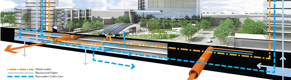
Integrated water & energy systems at Lloyd Crossing Catalyst Project. Image © by Mithun
The study concluded that energy and water systems could provide a clear return-on-investment, while habitat provides intangible value. To demonstrate the benefits of investing in the whole system, the design team suggested the use of a new type of financial model, a Resource Management Association, which gave property and systems owners an ongoing source of funds for achieving water, energy, carbon and habitat goals, while also providing funds for adopting new technologies.
In a high-density urban context such as Lloyd Crossing, it becomes quite evident that landscape or buildings alone cannot achieve the goal of returning the ecological performance of the site to predevelopment levels—in order to do so, the design needs to consider the total constructed urban system.

Streetscape at Taylor 28, with integrated street & building stormwater systems, [left]
Apartment-level view of sidewalk plaza after installation, [right]. Images © by Mithun
Taylor 28
Lloyd Crossing exemplified a district-scale design and planning effort, yet many urban projects take place on the much smaller scale of the block or parcel. Begun in 2004, Taylor 28, a 1.2-acre residential, mixed-use development in Seattle, Washington, showcases how metrics and integrated design tactics can be implemented on a smaller site, but with larger urban systems in mind.
In order to achieve its goals, this project implemented a boundary-breaking strategy that supports district-level landscape performance strategies. From the outset of the design process, the developer was eager to create a sense of place in a location characterized by both busy streets and empty buildings. Thus, public right-of-way was reorganized to provide more beneficial public space and developed and maintained with an agreement by private owners. The design team reclaimed twenty feet of underutilized public roadway in order to enhance public space and the quality of urban experience. The rainwater collected on the private land was used for irrigation in both public and private areas.

Pedestrian Environmental Quality Index of street intersections and streetscape at Taylor 28, existing and proposed conditions. Image © by Mithun
Taylor 28 also highlights the use of emerging metrics that measure the pedestrian environmental quality of streetscapes, in concert with artful stormwater design in a high-density location. A Pedestrian Environmental Quality Index (PEQI) was used to measure a baseline for pedestrian quality of the streetscape before and after the project was completed.
The PEQI was developed by the San Francisco Department of Public Health to assess the quality of the physical pedestrian environment and inform pedestrian planning needs. The PEQI draws on published research and work from numerous cities to assess how the physical environment impacts whether or not people walk within a neighborhood. A observational survey that quantifies street and intersection factors empirically known to affect people’s travel behaviors, the index is organized into five categories: traffic, street design, land use, intersections and safety. Within these categories, thirty indicators reflect the quality of the built environment for pedestrians and comprise the survey used for data collection. These indicators are aggregated to create a weighted summary index of pedestrian quality. This summary index was used as a framework at Taylor 28 to measure the success of the streetscape improvements.
The measured improvement of the pedestrian environment was designed in concert with several quantifiable strategies inspired by the Lloyd Crossing Sustainable Urban Design Plan. Canopy tree coverage and planting contribute to measured heat island reduction and CO2 offsetting. Rainwater runoff from the newly created sidewalk plaza percolates through permeable paving and into a series of urban rain gardens.

Plan view of enlarged sidewalk with plaza space, and stormwater planters. Image © by Mithun
The 197-unit apartment complex also utilizes strategies for energy use reduction, additional heat island reduction and stormwater collection that are integrated with site. For example, rainwater is captured from the roof and stored in a 16,000-gallon cistern. Annually, this rainwater provides over 58,000 gallons for all of the site’s irrigation needs, and 64,000 gallons to flush toilets in the retail areas. The overall stormwater strategy, which utilizes building and landscape, measurably reduces pressure on both potable water and combined sewage municipal systems.
The use of performance metrics contributed to the success of this project by helping to quantify the benefits of the design. By using a hybrid tank to meet the City’s detention requirement, the client was able to leverage the additional cost of incorporating rainwater reuse. The long-term water savings offset the added costs for flow sensors, filters, and doubled supply pipe to the non-residential toilets. The combination of right-of-way rain gardens and a roof rainwater harvesting system relieved the stormwater loads on city’s overburdened combined sewer system. By measuring the pre- and post-development conditions, the project clearly demonstrated its contributions to larger environmental goals and positive health outcomes, while the artfully designed and safe streets can be promoted as a neighborhood amenity and redevelopment catalyst for the area.
South Lincoln Redevelopment
Going further than Taylor 28, the South Lincoln Redevelopment in Denver, Colorado takes metrics to a much greater level of detail, and will be implemented on a comparatively larger scale. This HOPE VI funded project is a mixed-income redevelopment of the Denver Housing Authority’s South Lincoln Homes public housing site. The goal is to create a transit-oriented community where people experience a neighborhood that is environmentally sustainable, culturally diverse, close to downtown and offers a spectrum of housing options. Begun in 2009, the seventeen-acre master plan included many of the environmental strategies proposed at Lloyd Crossing.

Overview of proposed South Lincoln Redevelopment Master Plan. Image © by Mithun
The client and design team used metrics to provide a compelling way to define social sustainability and quality of life. The interdisciplinary design team including, which included a public health consultant, utilized a community-driven design process that included several health metrics, such as a Health Impact Assessment (HIA) and use of the Healthy Development Measurement Tool (HDMT).
An HIA involves a combination of procedures, methods and tools to evaluate how current conditions and future changes (of a project, policy or program) impact the health of a population. Conducted concurrently with the design team’s site analysis, the South Lincoln HIA analysis included not only the South Lincoln Homes, but also the broader South Lincoln neighborhood. Through the HIA process, the design team used evidence-based health data to assess potential human health risks and identify key issues.

Redevelopment Healthy Development Measurement Tool Analysis, [left]
Energy use analysis for South Lincoln Redevelopment Master Plan, [right]. Images © by Mithun
As the team moved from analysis to designing site options, it used the Healthy Development Measurement Tool to guide design strategies. The HDMT, developed by the San Francisco Department of Public Health, is a comprehensive tool and checklist geared toward improving health in urban development. The HDMT is organized into six categories: Environmental Stewardship, Safe and Sustainable Transportation, Social Cohesion, Public Infrastructure (amenities and services), Adequate and Healthy Housing, and Healthy Economy. Ultimately, both the HIA and HDMT process proved to be successful in attracting funding for the project, which has just completed its first phase of construction and has been cited as a best practice by the HUD-DOT-EPA Interagency Partnership for Sustainable Communities.
Next Steps: EcoDistrict Planning
Technologies and strategies for enhancing neighborhood sustainability such as district energy and water management systems, walkable green streets and resource conservation are well known, but their widespread deployment has been slow to develop. This is due not only to the lack of metrics that demonstrate ecological and financial value, but also to the lack of scalable project capital and public policy support.
The EcoDistricts Initiative focuses on removing these implementation barriers and creating an enabling strategy that accelerates neighborhood-scale sustainability in existing communities. Since 2010, Mithun has been collaborating with the Portland Sustainability Institute (PoSI), City of Portland and Portland State University on the EcoDistricts Initiative and neighborhood sustainability plans assessment protocol. A very comprehensive strategy, the EcoDistricts Initiative integrates building and infrastructure projects with community programs and individual action.

Assessment protocol for EcoDistrict planning. Image © by Mithun
The assessment protocol is part of a toolkit for EcoDistricts to understand their current district performance, set targets and develop district strategy recommendations in seven key performance areas, such as Habitat and Ecosystem, or Community Vitality. It is coordinated with a prototype system for collecting and visualizing relevant data, that is focused on informing decision-making and monitoring over time.
To test these concepts, the PoSI is working with five Portland pilot districts with distinct typologies, including the Lloyd District, to guide strategic planning, community engagement and catalytic investments. District stakeholders agree to set rigorous goals, develop a roadmap and implement projects. In return, PoSI and its public partners are providing technical and financial resources to support the work. As the essential building block of the city around which urban communities are organized and understood, the neighborhood can be seen as the most effective scale for radically improving urban environmental performance, and the EcoDistricts Initiative is putting in place the tools, strategies and support to scale up this change.

EcoDistrict Performance Areas with associated goals and potential metrics. Image © by Mithun
An Integrated Urbanism
In the decade since the Lloyd Crossing Sustainable Urban Design Plan, it has become increasingly clear that neither landscape nor architectural urbanism alone can achieve the results originally envisioned. Truly integrated and trans-disciplinary design teams are needed that include private developers, public agencies, institutions and non-profits who are willing to utilize both ecological and human health assessment tools to quantify the benefits of their work. These tools, coupled with neighborhood-scale financing techniques, public policy strategies and behavior change, must be incorporated into the design and planning process in order to radically improve human health and the urban environment.
 Christian Runge is a landscape designer at Mithun—an integrated design firm with offices in Seattle and San Francisco. He is passionate about working at the intersection of ecological and cultural processes within metropolitan and rural environments. His current work ranges from campus open space planning and design in the Puget Sound, to restoration planning in Yosemite National Park. He holds a MLA in landscape architecture and a BS in environmental biology and is an avid musician.