Depth n.
1. a dimension taken through an object or body of material, usually downward from an upper surface, horizontally inward from an outer surface, or from top to bottom of something regarded as one of several layers.
2. the quality of being deep; deepness.
3. complexity or obscurity, as of a subject: a question of great depth.
4. gravity; seriousness.
5. intensity of color or darkness
6. emotional profundity: the depth of someone’s feelings.
7. an unfathomable abyss

Oyster-tecture, MoMA Rising Currents Exhibition. © SCAPE / Landscape Architecture, 2010.
Introduction
Deep Urbanism is a reading of the city that acknowledges the complex ecological and biogeochemical processes taking place above, below and within the urban ground. In the city, nothing can simply be placed on the surface; the composition of the urban ground requires that structures inevitably extend deep into a complex mix of disturbed soil horizons, construction rubble, pipes, subways, utilities. The most innocent-looking walkway may sit on 30-foot piles driven deep into silty soil; small hillocks might be braced with highly engineered geotextiles. A simple meadow may require the complete reconstruction of a “natural” soil profile; a sunken garden may require drainage infrastructure and thousands of pounds of concrete to keep the water table at bay. Much of the action of landscape is deep underground, buried in space or time.
With more and more landscape projects today being built over infrastructure, over unstable soils, or even atop capped landfills, it is critical for landscape architects to deepen their understanding of complex site dynamics. While the visual action of landscape happens above ground, landscape architecture’s intelligence, technical problem solving and performative attributes often occur beneath the surface. However, landscape’s increased emphasis on highly graphic and conceptual plans has led to the de-emphasizing of depth and its associated behaviors and qualities, resulting in a shallow section.
The sentiments of deep urbanism recently surfaced in the 2010 “Rising Currents” exhibition at the Museum of Modern Art, where sectional drawings received a prominent showing as wall-length murals. This project brought together five interdisciplinary teams of architects, landscape architects and engineers to tackle the complex challenge of reimaging New York’s coastline and harbor in light of the pressing issues of climate-driven storm surge and sea-level rise, pollution and degraded coastal habitat. The long and detailed section became the dominant drawing for many of the teams due to its unique ability to address these issues and the underlying processes at play, in time and space, with more nuance and dynamism than conventional plans and perspectives could achieve.
While landscape plans and perspectives have achieved high levels of graphic refinement over the last decade, helping to increase the visibility of landscape architecture, sectional representation has lagged, not receiving the same level of graphic exploration and experimentation. Developing a fluency with “deep sections,” or sectional representation techniques that make visible the wide range of site complexity while providing a critical tool for interdisciplinary collaboration and design exploration, can be a start of a shift towards a deeper grounding in how landscapes perform.

Sectional axonometric: structural and landscape systems, Hudson River Park. MVVA, 2011. [left]
Section perspective: Salon de Pinos, Madrid Rio. West 8, 2006-2011. [right]

Section of Grand Central Terminal. Scientific American, 1912
The Layered City: Urban Depth
For landscape architecture projects to perform and persist over time, landscape architects need to not only design the benches, plantings, and pathways on the surface of the ground, but to have a deep understanding of the site’s underlying substrate, of the flows of water, traffic, and nutrients, of the architectural and infrastructural context of the site. No longer are these elements a disconnected pre-condition of a project, relegated to the purview of engineers or transportation planners, but an intimate part of the newly expanded scope of landscape. The urban landscape includes the actual ground on which the city is built and through which course its urban ecological flows and processes.
These ideas were well understood by the architects and engineers at the turn of the mid-nineteenth century who designed and built much of the conveyance infrastructure that lies beneath the feet of city dwellers today. The deep section draws inspiration from architects of the time—who argued fiercely for a better-performing city with wider streets, modern sewage, and faster new transportation systems—and architects of the 1910s and 1920s reveling in the complex newly infrastructural section of the modern metropolis.
European architects like Idelphons Cerda, in his search for a rational, scientific urbanism, and Adolphe Alphand, in his search for the ideal Haussmannian boulevard, drew new types of sections, through the street and its associated infrastructure. Cerda’s formulation of a new “ism”—urbanism—underscores the moment of excitement about the city that the Enlightenment was bringing to architecture.[1] Observing the young gridded cities of the Americas, here was an architect developing a philosophy of city-making and infrastructure in order to prepare for the radical expansion of the urban territory out from the old medieval urban cores. A decade later, Adolphe Alphand was experimenting with crafting new optimized sewered, planted, and traffic-separated streets through the existing medieval urban fabric of Paris. Alphond included street sections in his 1867-73 Les Promenades de Paris; as Jacqueline Tatom describes in her essay “Urban Highways and the Reluctant Public Realm,” Alphand’s representation of Haussmann’s Paris “reveals a programmatic richness that is enhanced by a careful exploration of the existing city.” [2] These urban sections acknowledge both the urban flows above ground and below it.

Infrastructural conditions of the present and future street, The Cities of the Future. Eugène Hénard, 1910.
In the 19th century, these were not considered interdisciplinary drawings; disciplinary boundaries between architecture, engineering, urban design and landscape had not yet hardened. Architects of the time understood that these elements were intimately connected, and that in order for the distinct elements of the project to be in conversation with each other, they needed to all appear on the same drawing.
In the first decades of the 20th Century, this urbanistic excitement continued, with exuberant sections exploring the multiple infrastructural levels of the layered city. A famous section drawing from the time, published in the Scientific American in 1912, shows New York’s Grand Central carved away to reveal all the flows coming together in this urban node. The city was being changed, mechanized, modernized, and urban society was fully engaged with these changes as they were taking place.
Modern architects continued to draw prototypical urban sections throughout the 20th Century, with influential urban sections being developed by Le Corbusier, Hilbersheimer, and later Paul Rudolph. But as disciplines such as civil engineering became codified and the below-grade infrastructure moved out of architects’ purview, architectural interests shifted upwards. The information below ground, or below the architectural foundation, faded from view, its memory relegated to the white emptiness of poché.
The use of poché –the hatched or shaded space inside the cutline–in sectional drawings indicates material or space which does not need to be considered. In architectural drawings, poché traditionally represents the space inside the wall, indicating areas not experienced or deemed superfluous to the focus of the drawing. In Nolli’s architectural mapping of public space of Rome, the city’s building fabric was represented as poché while the streets, plazas, and select architectural interiors were represented as an interconnected public “figure” within the larger field of urban fabric. Architectural drawings routinely represent the ground, and everything below the cutline or outside of the building foundation as poché, implying that this material is beyond the scope of the project.
Drawings are always partial views. The omission of information provides clarity and legibility of the design problem being worked out or expressed on the page. If we understand drawings to be a critical space for construction and exploration of architectural questions, then the designation of material, zones or properties as poché is a clear expression of the limits of the designer’s inquiry. When the properties relegated to poché matter deeply, then this omission should be cause for concern.
in-depth adj.
1. carefully worked out, detailed and thorough: an in-depth study
2. thorough, extensive or profound: an in-depth analysis of the problem.

Programmatic sections, Parc de la Villette, competition entry. Office for Metropolitan Architecture,1983.
Iconic/Graphic: The Shallow Section & The Programmed Surface
Half a century later, in the wake of decades of disastrous urban renewal projects and ongoing suburban explosion– architects, urban designers and landscape architects again sought a new mode for understanding the goals and guiding principles of contemporary city making. In the 1970’s and 80s, the popularization of the environmental movement, urban ecology and systems theory created a paradigm shift in our understanding of the complexity and dynamism of the urban fabric.[3] Again, descriptions of urban environments became infused with a language of flows and flux—this time not just the high-speed movement of the automobile and train, but also the varied and invisible flows of water and waste, migratory birds and hydroflurocarbons.
A new generation of architects and landscape architects were suddenly asked to operate on a landscape that was neither wholly natural nor machinic[4]. While this may have been a critical moment for a return to a critical understanding of subtle depth and process, instead design moved in the opposite direction, casting its vote for a simplified and ambiguous clarity.
Movements are born from a leader and an image. While the environmental movement galvanized around Rachel Carson and dying birds, landscape architecture inherited Rem Koolhaas and Parc de la Villette. OMA’s proposal for the Parc de la Villette competition remains a seminal project for contemporary landscape architecture, presenting a conceptual approach to landscape process and heralding the era of a new drawing style, the diagrammatic plan. The competition took at its foundation two critical challenges of the time—an artificial flatness of the post-industrial landscape and the heroic nature of large-scale land development.
The conceptual foundation of OMA’s submission is a celebration of program, whose diagrammatic clarity relies on the de-emphasizing of natural processes and their replacement with a field of architectural objects—some of which happen to be trees:[5]
“Nature—whether the thematic/discovery gardens, or “real” nature—will also be treated as program. Blocks or screens of trees and the various gardens will act like different planes of a stage set: they will convey the illusion of different landscapes, of depth, without offering, in passing, the substance.”[6]
OMA’s radical emphasis on program is a means of coping with, and perhaps mirroring, the impermanence and dynamic nature of cities. The project—conceptually and literally—exists purely above ground, and all elements that do not add to the construction of a visual experience are rendered mute. Sectionally, the park is built up (never down) in a series of theoretical and literal layers. The existing site, even the soil is characterized as “sterile” [7] and a tabula rasa condition is assumed. All fertility, all interest is imported. The weight of that effort is marked by topography—making all effect, all effort visible.
Koolhaas’ La Villette proposal is important to note, not for its failings, but for its conceptual strength and its graphic clarity—which proved capable of captivating landscape architecture and architecture for nearly two decades. The technique and polemic freed landscape architects to sell proposals through manipulation of program, rather than just physical elements, broadening the field of what was considered landscape and providing landscape architecture practitioners the agency to operate across large swaths of the urban fabric. By the late 90’s, however, the iconic diagrammatic flatness of landscape proposals had run its course, as evidenced by the demise of OMA’s winning Tree City competition proposal for Downsview Park.
Thirty years after La Villette, landscape architects and architects are still struggling with the flatness that came with the diagrammatic, ungrounded approach to landscape. Academic and professional exploration of folded and thickened surfaces within the city exhibit a desire to counteract this purported flatness of landscape, in order to express a more didactically complex reading of the urban surface. Topo-mimetic building projects such as FOA’s Yokohama Ferry Terminal, however, rely on a formal representation of landscape as a proxy for the desired complexity and dynamic processes of material sites.
Of course, scientific and experiential understandings of landscape patterns and processes challenge a purely formal rendering of landscape or architecture as “an abstract surface.”[8] In interpreting the “thickened ground”[9] of the urban landscape as an architectural condition of horizontally expansive (if programmatically complex) buildings, such explorations ignore and negate the significant biochemical, geological, hydrological, or ecological complexity of urban ground.

Slope planting strategy, “Lifescape,” Fresh Kills competition proposal. James Corner/Field Operations et al., 2005.
While the “thick 2-D” of the architcturalized urban section is capable of reproducing moments of drama, its reliance on the treatment of landscape as a metaphor ultimately exposes the thinness and immaterial nature of such projects.[10] Urbanism, of course, operates in four dimensions– existing fully in space and time.
While architects continue to struggle to express depth and dynamic performance through largely formal and narrative devices, contemporary landscape architects have re-embraced process and a hyperconnected view of nature through a re-engagement with the urban ground and its messy complexity. In this view, site conditions and contexts are treated not as a disconnected engineering problem, but as integral to the design strategy. In the projects and writings of landscape urbanism, we see once again an excitement for the crafting of a better-performing city, where an expanded scope of landscape architecture now includes the project of city-making, both above- and below-ground.
beyond one’s depth , out of one’s depth idiom
1. in water deeper than one is tall
2. beyond the range of one’s competence or understanding

Early concept sections, North Grant Park. Michael Van Valkenburgh Associates, 2011.
Drawing Deep Urbanism
If a Deep Urbanism is a reading of the city as a complex system composed of interconnected layers of social and biogeochemical processes, then the deep section is its primary graphic device for communicating a synthetic view. The deep section is an essential representational tool in expressing and addressing design challenges holistically—allowing varied processes to become visible and be explored relationally, rather than analytically. The deep section breaks away from reliance on the visual and apparent—creating space for the visualization of the processes of urban nature more readily than do plans and perspectives. The deep section also brings infrastructure, hidden both underground and in plain sight, to the forefront, expanding our understanding of the pre-conditions of projects and the boundaries of our interventions.
By extracting select elements from their usual places in spreadsheets and reports, and placing them together on the page, the designer is able to spatialize these processes or materials, while creating a dialectical tension between parameters that are usually relegated to different disciplines. Through a deep section, subsurface hydrology may be understood in relation to above-ground planting patterns, and below-ground structural capacity can communicate with above-ground topography and landform’s programmatic potential, all on one drawing.
Thirteen years before La Villette jolted landscape towards program and plan, Ian McHarg challenged landscape architects to learn the lessons of dynamic landscape systems, so that they might create more environmentally responsible projects. As ecology popularized discussion of flows, process, and systems of disturbance rather than equilibrium, McHarg opened the door to sectional explorations of process by focusing on dynamic landscapes such as shifting sand dunes and representing their behavior through sectional diagrams.[11] McHarg explained and popularized the use of diagrammatic sections during his tenure at the University of Pennsylvania during the 1960’s, 70’s, and 80’s.
A generation of McHarg’s students has continued to experiment with and adapt these techniques in order to explore a diversity of landscape dynamics. From McHarg’s original explorations, we can trace three primary types of deep section—the landscape transect, the structural section and the sequential section—each providing a critical method for the toolkit of deep urbanism. Each technique represents a field of concerns and drawing practices, some borrowed from other disciplines and others rooted in landscape architecture practice.

Ian McHarg’s Dune Community Types, from Sea and Survival, 1969
Landscape transects explore the interconnection between vegetation on the surface and the soil and hydrological behavior below ground. Transects drawn by ecologists are rooted in a methodology of sampling across a target site, represented in the composition of vegetative gradients which index shifts in the properties of soil and hydrology. Landscape architects can build on this technique in order to explore a wider range of conditions, many of which are specific to the constructed ecology of urban landscapes. Rather than cataloging found conditions, a deep landscape transect might start from the intended vegetation patterns of a landscape design and move down to describe the requisite soil horizons, drainage or irrigation regimes, and biological conditions necessary to support that vegetative community, acting as a generative tool for establishing proper growing conditions. It may need to incorporate elements of our second sectional lineage, structural and construction sections.
Whereas ecological transects are full of gradients, structural and construction sections, describe the actual dimensions, notations, and relations needed for building a landscape. Their principal tool is the measured line. This sectional typology makes a clear shift from description to prescription; hard lines in this type of representation are essential—at the very least lines of dimension and lines of movement. The structural section engages the spatial and temporal realities of acting on a heavily constructed ground, responding to the need to describe coordination among utilities, the work of various trades, structural loads, or relational properties of materials. Rather than emphasizing the fluid and dynamic properties of landscape, the structural or construction section embraces the conceptual and practical benefits of measurement and spatial precision.

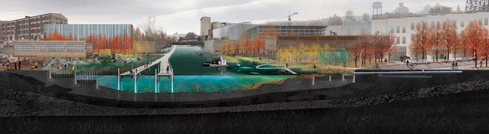
(Infra)structural sections, New Urban Ground. ARO and dlandstudio’s competition entry for Rising Currents Exhibition, 2010.
With ARO and dlandstudio’s Rising Currents entry, “New Urban Ground” for Lower Manhattan, we see an example of a deep (infra)structural section, where multiple flows (water, sewage, data, power, traffic) are managed through a smart and precise recalibration of the street and urban edge, re-thinking how the city can perform through optimized street details. The proposal argues that a re-consideration of street design can lead to a hydrologically better-performing city in an age of sea level rise and increased storm surge potential. These sections comment on the existing mess of utilities that lie below typical New York streets, and propose a new street section where utilities are reorganized into neat new ducts, livability has expanded with asphalt giving way to grass in the porous pavement, and the attenuating quality of a soft coastal edge to dissipate the destructive effect of storm surge has been carefully considered.
Sequential sections make use of multiple sectional cuts to express depth across space or time in order to show a narrative progression. On the surface, these sections often focus on the visible and spatial conditions of interiority, light, or landscape experience, but they can also be cut through time. For example, several notable projects have explored the processes of plant succession as a dynamic progression in order to explain the relationship between initial moves (i.e. creating furrows, planting seedlings in hedgerows, overplanting with the intent of later thinning out) and eventual outcomes. Field Operations used this technique to explain their planting strategy for Fresh Kills, illustrating the “successional development of ‘thicket’ planting on slopes into mature, multi-aged, stratified woodland,” while Michael Van Valkenburgh Associates used a similar approach to explain the spatial implications of pruning and maintenance in shaping their “successional hedgerows” for Brooklyn Bridge Park. STOSS LU borrows from Field Operations’ graphic convention and pushes it further to explain the relationship between forest succession and the creation of programmatic diversity through targeted landscape interventions such as the introduction of furrows, fences, and boardwalks.

Successional Hedgerow Development, Brooklyn Bridge Park. MVVA, Graphic by Mike Smith and Matthew Urbanski.

Physical operations: Minimal incisions and constructions that spark change, Mount Tabor Resevoir. stossLU, 2003.
In deepening these three examples, we might draw on our understanding that in addition to above-ground vegetation and biomass changes over time, shifting soil characteristics and root growth are also important factors to consider in the appropriate care of plant communities. A deep section approach might overlay information of below-ground dynamics in order to express the connections or synergies between aspects of maintenance activities (i.e. both the pruning of plants above ground and the addition of soil amendments, microorganisms or subsurface irrigation).
Sequential sections can also be used to move the viewer through space rather than time. As with the example below, this more experimental approach to sectional exploration seeks to move away from the dominance of the surface of plan in order to explore flows in three dimensions. Work from Anuradha Mathur and Dilip da Cunha’s Mumbai studios at the University of Pennsylvania has used the sequential section to trace a narrative progression through streets, waterways, rail lines and other infrastructural routes. Specific spatial conditions are represented in each individual section, while the entire progression of section cuts becomes a place to map flows and relationships.
Like the other deep sections typologies listed above, the sequential section remains a narrative and critical drawing—one which reserves the privilege of picking and choosing which pieces of information or spatial moments are important to render on the page. Sequential sections offer considerable flexibility and freedom to test design interventions and critically explore relationships without the need for an even coding or development of the plan.

Sequential sections through maidan edges, Filter/Collector: Anchoring the Edge in Mumbai’s Maidans. Nicholas Pevzner, 2009
In his introduction to Recovering Landscape, James Corner argues that it is less the formal characteristics of landscape, than the agency of landscape that is critically important for intervening in cultural convention. The focus, he argues, should be on “how it works and what it does” rather than what a landscape looks like.[12] Whereas other forms of architectural representation may better communicate the formal or aesthetic concerns of a project—whether a project is “naturalistic, rectilinear, curvilinear, formal, or informal”—sectional drawings cut right past the plan aesthetic. Able to be drawn quickly and early in the design process, sections offer a powerful generative, communicative and analytical tool. The deep section designates a physical space in which a project’s unknowns, goals and constraints can be drawn and tested. The “deep section” holds out promise as the graphic platform for convening the interdisciplinary conversation necessary to solve the complex and layered challenges of contemporary urban landscape projects within a medium that is native to landscape architecture.

Nicholas Pevzner is a designer at Michael Van Valkenburgh Associates in New York City. His work explores the role that infrastructural landscape moves can play in structuring and sustaining healthy cities. Nicholas received his Bachelor of Architecture from the Cooper Union in New York in 2005. He later received his Master of Landscape Architecture from the University of Pennsylvania in 2009, where he has also been a visiting lecturer and critic in landscape architecture. He is a co-editor of this issue.

Stephanie Carlisle is a designer and environmental researcher at KieranTimberlake Architects in Philadelphia. Her research focuses on the relationship between the built and natural environment and employs interdisciplinary design methodologies and data-driven modeling to study complex urban systems. Stephanie holds a Master of Architecture from the Yale School of Architecture and a Master of Environmental Management from the Yale School of Forestry and Environmental Studies. She is a co-editor of this issue.