Big Old Tree, New Big Easy

It is a warm day in City Park as I wander through an older grove of live oaks.  The trees, with their hulking trunks, twisted branches, and extensive protruding roots, create rooms, ceilings, and seats around me.  Their forms speak easily to timeless architectural features.  Though massive in size, the trees are incredibly accessible – their features so familiar and human-scaled—as proven by the visitors so often found tucked into a crook of their branches or hanging upside down amid the Spanish moss. These trees are nurturers of place, nostalgic fortresses, and ecological strongholds.   Existing well before Katrina or even before the 18th century European settlement, they might be considered the oldest and most sustainable ‘architecture’ in the city.  They are big; they are old; and these monuments of fortitude are fundamental to the future landscape of New Orleans.

This project ‘Big Old Tree; New Big Easy’, was a result of an advanced studio in landscape architecture and regional planning at the University of Pennsylvania.  At its core, it is an adaptable design proposal built upon the inherent qualities of New Orleans’ native tree species. By exploring a diverse set of values and dynamics, such as the rich historical identity of the trees, their capabilities for environmental and hydrological mitigation, and the social and economic investment that such an urban forestry project demands; this project speaks to the potential of a simple urban forest strategy to engage the past, respond to critical current issues, and maybe most importantly, nurture a ‘sustainable’ future.

Lutsky_tree types

Native tree systems: Live oaks structure gathering places within the corridor as well as grand allees that expand up and out of the corridor. Pecan orchards extend out into the neighborhoods, connecting to existing schools and new ‘volun-tourism’ hubs. Cypress and Tupelo lowlands are tied to the water system that extends north through the corridor.


The site, the city, the trees

The project site of Iberville and the Lafitte Corridor suffers from a number of challenging urban features including a run-down, half-empty, public housing project and a long abandoned swath of under-utilized land. Severely disconnected from the city by fences and discontinuous streets, it is an area characterized by high rates of vacancy and lacks both vitality and function.  Its location, on relatively high ground and adjacent to cultural hot spots such as the French Quarter, Congo Square, Treme, and Bayou St. John, along with recent community interest and efforts involving the site, suggest that it is prime for revitalization and sustainable re-development.  Historically, the neighborhood was built on the edge of New Orleans’ backswamp, and the land, which was once covered in water-loving cypress and tupelo, was systematically drained and settled.  The severe effects of this urban settlement approach and the city’s dire need for new water mitigation strategies have become more clear with each passing storm, and are an essential consideration for any future urban proposal.

Lutsky_Live Oak Trees in New Orleans

Big New Orleans’ Tree Tradition: Live oaks line streets and populate small parks.

While increasingly notorious for its flooding vulnerabilities, New Orleans is better known for its unique history, and rich cultural heritage, and its trees are no exception.  New Orleans’ trees, from the massive live oaks in City Park and the allées lining St. Charles Boulevard, have long been a part of the city’s structural and social identity. Their very existence as big, old trees points not only to the strength and durability of their native adaptations, but also the significance they so clearly hold for the people of New Orleans.  Some recent planning proposals for New Orleans such as those examined in the ‘Dutch Dialogues’ workshops focus on the use of highly engineered strategies to help manage the city’s mounting hydrologic issues.  In addition to these often hard infrastructural approaches, a softer infrastructural system could also be implemented to help alleviate the city’s hydrological burden, both on a daily basis and during large storm events. For such a system, I propose we take another look at these veteran trees of the city.   We can see in their expansive canopies a basis for a simple but powerful long-term planning and planting strategy for the city, and more specifically for the re-vitalization of the LaFitte/Iberville community.

Lutsky_Socially Significant Species

Socially Significant Species: These three planting typologies, the live oak, the pecan, and the bald cypress, are environmentally adapted, socially significant, and have attributes that can be utilized to improve hydrological, social and economic function of the site. 


‘Big old tree, big new easy’

With this understanding, ‘Big Old Tree, New Big Easy’ begins and ends with the trees.  The plan uses well-known attributes of three native tree typologies (the high-ground live oak, the mid-ground pecan, and the water-loving cypress) to maximize the capacity of the resulting urban canopy to manage water through evapo-transpiration, to stabilize the currently sinking ground with extensive root systems, to connect neighborhoods and promote recreation with new shade and structure, to produce valued goods such as nuts and wood, and to harbor and nurture the growth of a strong community.   The native planting plan, program, and phasing strategy of this urban forest ensures the success and ability of this landscape to support such hydrologic, economic, and socially rich functions by being both physically and conceptually accessible and adaptable.

Lutsky_Plans

Master Plan for the Laffitte Corridor and Iberville: As the corridor structures and supports a large new urban canopy, the Iberville neighborhood is updated to support a denser residential/commercial organization, including a new ‘restaurant row,’ renovated housing, a new voluntourism center and a pedestrian-friendly core.  The neighborhood connects to a transformed Louis Armstrong Park in which a number of new cultural amenities such as an outdoor concert venue, sculpture garden, and marketplace find a place among the trees and a new ‘urban swamp.’


Accessibility

In order to successfully engage community, this project relies on both physical and conceptual accessibility.   Physically, the project’s programmatic locations, early phased implementation, and management are all planned to draw upon and nurture the existing community and support future growth.  Maintenance-heavy areas such as orchards and community gardens are located adjacent to schools and community centers. The labor of planting and pruning trees, and harvesting fruit and wood is work that is easily managed, quickly taught, and carried out with minimal skill.  This allows it to be managed by a volunteer-based, multi-generational workforce without much risk, and lends itself well to larger group participation, promoting communal interaction and engagement.

Lutsky_Voluntourism

Volun-tourism and Community Connections: Pecan orchards located near schools and community centers offer both a new social program and potential industry for the corridor.  The orchards become places of community interaction with both locals and ‘volun-tourists’ visiting the city.

Utilizing the availability of the city’s post-Katrina ‘volun-tourism’ work-force, provides an initial source of people and communities that already value and have experience in collective organization.   The ‘volun-tourists’, people from around the country volunteering their vacation time to assisting the city in its rebuilding efforts, are able to stay in the renovated Iberville as they work with the local community and land, and in doing so, create their own connections to the neighborhood and the city.   Through all this community involvement, the Lafitte Corridor becomes a place that cements cultural interaction and investment through satisfying and socially engaging work, and begins to establish what might be considered an ‘emotional value’ in the land while keeping the costs of the project lower and more attainable.

XX_Lutsky_Phasing_740h

Phasing and Flexibility: The initial planting plan is meant to be flexible and adaptive to the future needs of the community. While certain trees will be managed for old growth, others are planted in tight groves that may be thinned out over time, serving as a nursery that will continually transplant the trees out into the neighborhood areas. Adaptive management will allow for the thinning out of these initial plantings to create playing fields and gardens when needed.

As they grow, the trees also begin to engage the community and realize their accessibility in new ways.  Early phasing of tightly planted groves in the project require that trees be thinned out over time.  This management  practice not only supports the healthy maturation of old-growth trees in the corridor, but also provides a ‘nursery’ source for native trees that may be transplanted into rest of the community, allowing the maintenance of the corridor to continually populate the greater neighborhood with these trees. Such thinning efforts are particularly important to manage for the longevity of the native live oak species and promoting the accessibility of the tree’s very form.  The live oak tree form holds structural qualities that in some ways speak to community more than any other old-growth tree.  For unlike the towering old sequoias or the old-growth pines that survive through minimal growth to withstand extreme conditions, as the live oak grows, it extends.  Its growth pattern includes shallow, long roots that often protrude upwards, and branches that reach outward and eventually downward as a result of their great density and weight.  This growth pattern allows these trees to have expansive canopies that invite human interaction in the form of spaces for play or gathering.

The many possibilities for physical engagement with the trees also points to the conceptual accessibility of this project.  At the most basic level there is a universal understanding in the value of trees, especially the ones we live with.   Trees track the seasons with their changes and sustain us with oxygen and wood; our bodies are inextricably linked to them. Trees also reference a time scale not found in our increasingly hurried urban environment.  Unfazed by human lifetimes and political cycles, trees remind us that true sustainability requires long-term investment.

Lutsky_striation

Phasing Striations and Adaptability: The striated patterning of the trees and the ground ensures visibility, structurally unifies the corridor, and promotes localized flooding and water infiltration.


Adaptability

The project’s ability to most efficiently function socially, economically, and hydrologically, lies in its overall ability to adapt thanks to flexible and responsive planting and phasing strategies. For example, through the armature of a striated planting plan, trees are planted linearly and are able to be adjusted in spacing and species in response to any number of different ground conditions.  This formation creates a planting plan that provides consistency across the landscape, structurally unifying and visually connecting the entirety of the corridor.   The responsive planting strategy places water-loving trees on wetter ground, pecan or harvestable trees near schools and local community organizations, and live oaks on high ground and along the main path. The simplicity of the planting plan also allows the project to continue to function under even the most lapsed maintenance. There may not be a fast and immediate return, but ‘quick fixes’ rarely hold long-term sustainable benefits  As a stand of trees, the project will be able to hold a structure that is identifiable over time. Even if nothing beyond the initial planting of the trees is implemented, the trees will still provide the much needed functions of mitigating water, creating habitat, cooling urban climate, increasing the quality of our air, and ensuring another crop of ‘big, old trees’ for the next generation.

Lutsky_urban swamp

Urban Swamp: Establishment of new catchment areas and water-loving, water-absorbing trees within the corridor re-establish moments of the city’s historical swamp origins and allow for the unique experiential immersion into a true ‘urban swamp.’


This proposal received a 2011 National ASLA Honor Award in Analysis and Planning.


Karen LutskyKaren O. Lutsky is currently an adjunct professor at Pennsylvania State University’s Stuckeman School of Architecture and Landscape Architecture. Her more recent design research focuses on landscape architecture’s role in the constructed coastlines of the Great Lakes and the potential of the lakes’ re-emergent land to address their larger environmental issues and establish healthier relationships between people and the water.  Her work and teaching also incorporates her interests in the accessibility of the design process and design literacy as essential components in the establishment of regional landscape identity and the re-vitalization of large post-industrial sites. She holds a B.A. in Environmental Sociology from Brandeis University and an M.L.A. from the University of Pennsylvania.


50,000 Trees

Freeways and highway overpasses are often seen as the epitome of environmental destruction in the urban landscape. Yet the complex spaces below and around urban freeways could be productively re-imagined as beneficial working landscapes, deploying trees en masse to buffer the harmful effects of these traffic conduits. Consider that freeways emit copious amounts of Carbon Dioxide (CO2), while trees naturally sequester CO2. Many urban freeways possess neglected right-of-ways, while forests require space.  This project explores how freeway urban forests could strategically offset a significant part of the city’s carbon emissions at the source.

As of 2012, 34.5 billion tons of Carbon Dioxide (CO2) were emitted annually worldwide [1].  The San Francisco Bay Area contributes 88 million tons annually [2].  Currently anticipating two million additional residents by 2040, the San Francisco Bay Area will face inflated emissions [3].  Recent studies suggest that densely planted urban forests can sequester CO2 to offset some of these emissions [4].  Urban forests also improve air quality, increase property values, provide enjoyable streetscapes, and establish buffers [5,6,7].  Freeway right-of-ways represent opportune land for locating sequestering forests in cities. They are some of the only remaining vacant land in the urban landscape, they are often underutilized, and many are adjacent to residential areas.

In this project, a 30-acre site of underutilized space beneath a multi-level interchange in San Francisco, CA is envisioned as a productive urban forest. The design for the site has three primary goals.  First, it seeks to plant a robust forest of enough trees to partially offset annual CO2 emissions from the adjacent freeway. Second, it devises an irrigation system that builds upon existing infrastructure to irrigate the forest and to reduce persistent stormwater flooding on this former marshland. Third, it establishes pedestrian pathways and provides amenities throughout the forest to create a memorable and interactive landscape. The forest is envisioned as a new type of urban landscape that emerges over time, transforming the driving experience at the freeway level and establishing places for pedestrian interaction at street level. If the freeway is rendered obsolete in the future, the interchange would transition from a mono-functional freeway into a multi-use interchange for pedestrians, public transportation, flora, and fauna amid a dense urban forest.

Moos_50000_01

Emerging Urban Forest: a 30-acre site of underutilized space located beneath a multi-level interchange in San Francisco, CA is envisioned as a highly productive sequestering urban forest of 50,000 trees that reduces storm water runoff and humanizes the street level, making it accessible, safe, and enjoyable for the public. 


Emerging Carbon Forest

As an experiment in carbon sequestration, the project proposes to partially offset the yearly carbon emissions of the interchange within its footprint. CO2 emissions were calculated for the interchange using transit authority vehicle counts and average levels of annual emissions [8,9,10].  Within the expanse of the interchange, vehicles emit 1,040 metric tons of CO2 annually.

Research of contemporary forest sequestration techniques finds that an average mature tree can sequester 48 lbs of CO2 annually (or 0.0217 metric tons) [11,12,13,14].While studies suggest that carbon sequestration varies based on the species and age of the tree, the amount of carbon dioxide sequestered is directly related to the total biomass of a given tree [15,16,17]. Young and fast growing trees that rapidly accumulate biomass will uptake more CO2 than mature, slow-growing trees with limited annual growth [18]. Trees that possess large trunks, roots, branches, and leaves (respectively), those that are appropriate for the climate, and those that are coniferous or deciduous will also sequester increased amounts of CO2 [19]. Therefore, tree selection for the interchange includes eight rapidly growing trees known to thrive in San Francisco, including conifers and deciduous species with high levels of biomass [20]. The project utilizes this data for the site to estimate that an individual tree can sequester 48 lbs of CO2 annually.

Sequestering 1,040 tons of CO2 using an urban forest would therefore require 48,000 mature trees. If planted 12 feet apart, 300 mature trees can fit within a single acre and sequester 6.5 tons/acre of CO2 [21]. This planting regimen would require 160 acres to sequester all 1,040 tons of CO2.

Innovative planting methods have demonstrated that carbon sequestration can be done increasingly more efficiently than previously thought, making it feasible for small urban sites such as this one to play an important role in offsetting urban emissions. A study on biomass production and carbon sequestration potential in poplar plantations found that CO2 sequestration increases from 6.5 annual tons/acre to 30 annual tons/acre when specific planting and management strategies are used, such as planting trees 3 meters apart and cycling trees every 6 years [22]. The project’s design takes advantage of these innovative forest sequestration techniques, resulting in a cycling strategy that alternates phases of growth, partial removal, afforestation, and diversification. This compact planting and maintenance strategy allows for the sequestration of a portion of the 1,040 tons of CO2 and other emitted compounds within the available 30 acres rather than the otherwise required 160 acres.

Moos_Phasing


Buffer & Grow

The I-280/HWY-101 freeway interchange is a multi-story structure spanning 1 mile in each direction. The freeway was built in the 1950’s with the sole purpose of rapid transportation, neglecting its context and surroundings. The massive structure divided residential neighborhoods that now line both sides of the interchange. It created narrow, dark, dirty, and dangerous sidewalks for pedestrian interchange at street level. For years, the freeway has subjected the neighborhoods to increased levels of emissions, noise, and neglect, perpetually decreasing real estate values and increasing asthma rates.

In addition, the interchange is located in a narrow valley and sits atop a former creek, slough, and extensive marshland. The waterways are confined to an underground culvert and are responsible for significant annual flooding. The valley is also known for extreme winds that billow across the interchange and are currently an untapped resource.

Today the freeway prevails as a mono-functional infrastructure that is destructive to its surroundings. In an era of growing populations, decreasing urban space, increasing emissions, and improving awareness of public health, we must re-design our infrastructure and available space to perform as a multi-purpose resource.

By employing an urban forest at the interchange, San Francisco would gain environmental and urban benefits on a range of scales. First, a vegetated buffer would emerge over time between the freeway and neighborhoods, absorbing sound and particulates. Second, walkways through the forest would improve connectivity and walkability between neighborhoods. Third, the devised catchment and irrigation system would mitigate annual flooding, reintroduce habitat to the area, and capitalize on available wind energy. Fourth, the forest would become a new open space for San Francisco that offers varied experiences and amenities not offered elsewhere in the city. With these improved conditions, property values of surrounding neighborhoods would likely increase. The estimated $1.7 million of annual city benefits generated at the interchange – including trees, soil, captured water, wind energy, and jobs – can then be used to expand the urban forest to least 90 other underutilized freeway right-of-ways throughout the entire San Francisco Bay Area [23]. Taken together, the resulting urban forest would become a “new and powerful” sequestration infrastructure functioning at the metropolitan scale.

Accumulating Forest

Accumulating a Forest Over Time: an initial planting of Vicia faba — fava beans — rapidly increases nutrient soil accumulation to support the later stages of afforestation. Employing an intensive planting and maintenance regime, the forest emerges over 100 years and accumulates 50,000 trees. 

 Moos_Planting Strategies

Planting Strategies: Employing intensive forest management techniques that increases CO2 sequestration from 6.5 tons/acre to 30 tons/acre annually, [24] trees are planted 3 meters apart and cycled every 6 years through a process of growth, partial forest removal, afforestation, and diversification.

 Moos_Tree Selection

Tree Selection: species are selected based on their known pollutant-removing capabilities; their known ability to thrive in San Francisco; their rapid growth rate; and their large trunks, roots, branches, & leaves [25,26].

 Moos_Sand Filter

Water and Wind: The average urban tree requires 782 gallons of water per tree per year [27]. Overhead, thousands of gallons of stormwater accumulate on the freeway deck during rain events. This project proposes a multi-tiered regenerative catchment and irrigation system that latches to the existing freeway infrastructure. The stormwater is captured in a gravity-fed sand filter that runs alongside the freeway, filtering storm water from existing drains while directing the water into a sunken, on-site cistern. Wind turbines above the freeway capitalize on excessive valley winds to power pumps in the cistern that aerate the captured stormwater.

 Moos_Forest Floor

The Forest Floor: an elevated central boardwalk, constructed from trees grown on-site, promotes year-round access while the central swale accommodates a range of seasonal flooding, pedestrian experiences, and vantage points. Water is pumped from the sunken cistern through piping that extends across the forest floor. The piping is designed to move and adapt as the forest grows, and as soil and tree litter accumulate. 

 Moos_Interchanges

The System: While this project focused on one specific interchange, an emerging freeway forest could occur on at least 90 additional interchanges throughout the San Francisco Bay Area, creating a significant sequestration infrastructure at the metropolitan scale.

 Moos_The Forest

The Forest: applied to all freeway interchanges and right-of-ways throughout the city, a corridor of CO2-sequestering forests would emerge and serve as a buffer that promotes healthier, more attractive, livable cities.


The City of San Francisco has utilized the research, analysis, and design of this proposal to inform aspects of the recently released 2014 Urban Forest Master Plan for the City of San Francisco, Ca. The Urban Forest Master Plan is a component of the One Bay Area Plan that is aimed at offsetting emissions through innovative solutions.

This proposal received a 2013 National ASLA Honor Award in General Design.

Acknowledgements

The author would like to acknowledge Judith Stilgenbauer, Associate Professor of Landscape Architecture at University of Hawaii at Manoa School of Architecture, formerly at the University of California, Berkeley, with whom the project was conceived.


Moos_144x144pxSarah Moos is an Associate at Bionic, a landscape architecture and planning firm based in San Francisco, CA. The firm focuses on inventiveness in landscape projects at all scales as an agency for enabling life and stimulating culture in the modern conditions of the world today. Moos graduated with ASLA high honors from the University of California, Berkeley with two master’s degrees in Landscape Architecture and Urban Design. Her work combines critical analysis and urban scale thinking that strategically integrates landscape, ecology, infrastructure, and social factors in the public realm to activate underutilized urban space.  Her work was recently recognized in the 2013 Samsung Everland Landscape Design Awards and the International Architectural Thesis Awards, emphasizing her critical analysis and urban scale thinking that strategically integrates landscape, ecology, infrastructure, and social factors in the public realm to activate underutilized urban space.


Notes

[1] Joe Oliver, et al., European Commission, “Trends in Global CO2 Emissions: 2013 Report,” PBL Netherlands Environmental Assessment Agency, 2013.
[2] Association of Bay Area Governments and Metropolitan Transportation Commission, “Bay Area Plan, Environmental Impact Report,” (Web sourced data, One Bay Area, 18 Jul 2013) accessed Oct 2013, http://onebayarea.org/plan-bay-area/plan-elements/environmental-impact-report.html.
[3] Association of Bay Area Governments and Metropolitan Transportation Commission, “Plan Bay Area,” (Web sourced data, One Bay Area, 18 Jul 2013) accessed Oct 2013, http://onebayarea.org/plan-bay-area/plan-elements/environmental-impact-report.html.
[4] S. Fang, J. Xue, and L. Tang, “Biomass production and carbon sequestration potential in poplar plantations with different management patterns,” Journal of Environmental Management 85: (2007): 672-679.
[5] David J. Nowak, “Tree Species Selection, Design, and Management to Improve Air Quality,” (2000 ASLA Annual Meeting Proceedings, St. Louis, 2000)
[6] “NYC’s Urban Forest,” MillionTreesNYC, accessed Oct 2011, http://www.milliontreesnyc.org/html/about/forest.shtml.
[7] “Appendix A – TM1: Benefits of Trees in Urban Areas,” Colorado Tree Coalition, accessed Oct 2011, http://www.coloradotrees.org/.
[8] “Traffic Branch Data: Year 2011,” California Department of Transportation, accessed October 2011, http://traffic-counts.dot.ca.gov/.
[9] Environmental Protection Agency, “Emission Facts: Average Annual Emissions and Fuel Consumption for Gasoline- Fueled Passenger Cars and Light Trucks,” (EPA, 2008), accessed October 2011, http://www.epa.gov/otaq/consumer/420f08024.pdf
[10] Other annual emissions calculated include: CO (Carbon Monoxide, 116,358 lbs), VOCs (Volatile Organic Compounds, 12,674 lbs), Ozone (HC, 17,673 and NOx 8,766 lbs), and PM (Particulate Matter, 3.9 lbs). Environmental Protection Agency, “Emission Facts: Average Annual Emissions and Fuel Consumption for Passenger Cars and Light Trucks,” (Web-sourced data, EPA, 2008), accessed October 2011, http://www.epa.gov/otaq/consumer/420f08024.pdf.
[11] “Appendix A – TM1: Benefits of Trees in Urban Areas,” Colorado Tree Coalition, accessed Oct 2011, http://www.coloradotrees.org/.
[12] Mike McAliney,  “Arguments for Land Conservation: Documentation and Information Sources for Land Resources Protection,” (Trust for Public Land, Sacramento, CA. 1993).
[13] Nowak, “Tree Species Selection, Design, and Management to Improve Air Quality.”
[14] “Carbon Sequestration through Reforestation,” EPA, Office of Superfund Remediation and Technology Innovation, accessed Oct 2011,  http://www.epa.gov/aml/revital/cseqfact.pdf.
[15] McAliney, “Arguments for Land Conservation: Documentation and Information Sources for Land Resources Protection.”
[16] Nowak, “Tree Species Selection, Design, and Management to Improve Air Quality.”
[17] US Department of Energy, “Method for Calculating Carbon Sequestration by Trees in Urban and Suburban Settings,” (Energy Information Administration 1998), http://202.116.32.252:8080/maths/uploadfile/2013/1204/20131204110004766.pdf
[18] McAliney, “Arguments for Land Conservation: Documentation and Information Sources for Land Resources Protection.”
[19] Fang et al, “Biomass Production and carbon Sequestration Potential in Poplar Plantations with Different Management Patterns,” 672-679.
[20] Mike Sullivan, “Tree Survey” SF Trees, accessed October 2011, www.sftrees.com.
[21] “Number of Trees per Acre by Spacing,” The University of Georgia, modified December 1996, http://warnell.forestry.uga.edu/SERVICE/LIBRARY/for96-054/index.html.
[22] Fang et al, “Biomass Production and carbon Sequestration Potential in Poplar Plantations with Different Management Patterns,” 672-679.
[23] MillionTreesNY, 2011.
[24] Fang et al, “Biomass Production and carbon Sequestration Potential in Poplar Plantations with Different Management Patterns,” 672-679.
[25] Fang et al, “Biomass Production and carbon Sequestration Potential in Poplar Plantations with Different Management Patterns,” 672-679.
[26] Mike Sullivan completed a thorough survey of trees known to thrive in San Francisco, Ca.
[27] “Watering,” MillionTreesNYC, accessed October 2011, http://stewardship.nycparks.org/library/watering.php.

How Many Trees Are Enough? Tree Death And The Urban Canopy

Introduction

Massive city tree planting campaigns have invigorated the urban forestry movement, and engaged politicians, planners, and the public in urban greening. Million tree initiatives have been launched in Los Angeles, CA; Denver, CO; New York City, NY; Philadelphia, PA, and other cities. Sacramento, CA even has a five million tree program. These planting campaigns – and urban forestry programs in general – are justified by models that estimate and monetize the environmental and socioeconomic benefits of trees [1,2]. These ecosystem services, defined as “the benefits that humans derive from nature,” play a major role in urban natural resource management [3,4].

However, realizing the ecosystem services associated with planting depends on tree survival. Despite the major focus on city tree planting over the past few decades, Nowak and Greenfield found that overall canopy cover levels in major US cities have been declining [5]. As these authors noted, “it is apparent that tree planting and natural regeneration are insufficient to offset the current losses.” With major new planting campaigns, how many of those trees will survive for decades, reaching a mature size at which their environmental and socioeconomic benefits are greatest? How many trees are enough – that is, how many need to be planted to make a lasting impact, and meet a city’s canopy cover goals? What are the implications of future tree death for managing the urban forest, in terms of cycles of tree removal and replacement? Answering these most basic questions in urban forest planning requires information about tree mortality and growth rates.

Sacramento's Tree Canopy

Figure 1. The urban forest canopy of Sacramento, CA in the spring. Image courtesy of the Sacramento Tree Foundation.

Unfortunately, long-term studies are sorely lacking for city trees. While cities rely on urban forest assessments, such as inventories and canopy cover analysis, to guide management, planning, and policy [6], long-term monitoring and associated mortality data are key missing pieces. Projected losses for the million tree campaigns demonstrate the importance of mortality data for estimating environmental benefits. The mortality rate patterns embedded within tree population projections for New York City [7] are based on a single study of maple street trees from Syracuse, NY [8], and survival scenarios for Los Angeles [9] do not cite any particular field studies. These and other authors have noted that mortality rates are a major source of uncertainty in predicting urban forest change over time. In the study about Los Angeles’ million tree program, a low mortality scenario projected that 17% of planted trees would be dead after 35 years, and a high mortality scenario projected 56% mortality.

These huge differences in mortality assumptions led to a large range in anticipated benefits: $1.95 billion to $1.33 billion in ecosystem services for the low and high mortality predictions, respectively. While mortality field data in Los Angeles has not yet been reported, we can compare the Los Angeles predictions to observations with MillionTreesNYC and the Sacramento Shade Tree program (Figure 1). For street trees in New York City, eight to nine years after planting, 26.2% were dead [10]. For a yard tree give-away program in Sacramento, five years after planting, 29.1% had died, on top of 15.1% that were never planted by residents [11] (Figure 2). For these yard and street tree examples, over a quarter of the trees planted died within the first five to nine years, and furthermore, for the tree give-away, some trees never made it into the ground. The Los Angeles low mortality scenario therefore appears overly optimistic.

While researchers have noted the importance of understanding mortality and generating long-term data, local practitioners have already started tracking the trees that they plant and manage [13]. Yet these practitioner-led efforts are somewhat isolated, and rarely documented in publications [14]. Journalists and bloggers have begun asking questions about tree survival in the massive planting campaigns as well, with article titles such as “A million trees? Only if we can keep them around” [15]. Given the call for monitoring the success of urban tree planting programs from the public, urban forest professionals, and researchers, the timing is ripe to finally embark on a nationally coordinated monitoring network. Towards this end, a new collaborative endeavor is underway to develop standardized tree monitoring protocols. By generating data that can be compared across cities and programs, we will enhance our ability to understand tree mortality rates and causes [16]. This kind of data can feed both academic and applied interests, from studying the biophysical and socioeconomic drivers of urban tree mortality, to recording tree survival as an indicator of local program success. While it will take years for us to produce the long-term data sets we seek, we can strive in the meantime to promote a common understanding of the role tree death plays in urban forest management.

In this essay, I discuss street tree mortality in terms of demographic concepts, and advocate for the application of these approaches in urban forest planning. Demography – the statistical study of populations – is used to analyze mortality trends and project future changes in systems ranging from human societies to endangered wildlife communities and natural forests. The same concepts and calculations used by actuaries (to determine risk of death for life insurance) and conservation biologists (to assess species extinction risk) can be used to study tree death in cities. While street trees do not encompass the entire urban forest, they are a major focus of tree planting and management operations, and are often the first line of public engagement with tree planting and stewardship. As we produce more long-term data in the years ahead, we will be able to compare different site types within the urban forest, such as streets, yards, and parks, and tailor population projections to the varied management regimes and species palettes within the urban forest landscape.

Roman_YardSurvival-Sacramento

Figure 2. Yard tree survival in Sacramento County, CA from a tree give-away program: a tree that survived [left]; a vacant, foreclosed property where trees were never planted [right]. In this study, some trees were lost due to failure to plant, in addition to post-planting mortality [12]. Images © Lara Roman.


Street tree lifespans

A common notion heard among arborists and urban planners is that street trees live, on average, for seven years. This figure comes from a 25-year-old article stating that suburban trees have an average lifespan of 32 years, and street trees seven years [17]. A similar study published a few years later reported that downtown trees have an average lifespan of 13 years [18]. These numbers were based on a questionnaire sent to urban foresters across the US, asking the local experts to estimate the typical tree lifespans in their cities. However, the questionnaire-based figures should be replaced with field data for a more accurate representation of urban tree longevity. In the decades since those articles were published, several more studies have reported primary field data on street tree death, offering the opportunity to combine results. Based on my analysis of 11 previous studies, the typical street tree mean life expectancy is 19-28 years, and the annual mortality rate is 3.5-5.1% [19]. This is far longer than the seven or 13-year figures previously reported. In fact, if the mean life expectancy was truly seven years, annual mortality would be 13.3%, far higher than the rates reported in published studies. While the mortality scenarios in ecosystem services projection models might be overly optimistic, the seven-year lifespan idea appears to be overly pessimistic. For purposes of natural resources planning and ecosystem services models, we need realistic expectations based on observations, rather than overly optimistic or pessimistic speculations.

Additionally, mean life expectancy may not be the best metric for communicating about urban tree longevity and death. As the average lifespan across all individuals, the mean life expectancy becomes very high when just a few individuals reach old age. A term with more practical application to managers is the population half-life: the time by which half of the planted trees can be expected to die. With the typical street tree mortality rates of 3.5-5.1% mentioned above, the population half-life is 13-20 years [20] (Figure 3). In other words, for every 100 street trees that get planted, only 50 will make it to 13-20 years [21]. These field data on urban tree mortality suggest that as the number of trees originally planted die over time, community foresters have to keep replacing trees, year after year, to have any chance of increasing population counts and canopy cover.

Roman_Survivorship Curves

Figure 3. Survivorship curves with population half-life: Survivorship curves for street trees when annual mortality is constant at 5.1 or 3.5%, as estimated from a meta-analysis of previous studies, adapted from Roman and Scatena (2011) [22]. These curves depict exponential decay in cumulative survivorship. The population half-life is the time at which half the population has died (survivorship = 50%). Note that survivorship curves are often drawn in the demographic literature with log-transformation, but that this graph is not log-transformed for ease of interpretation.


Tracking population fluxes

To understand changes in urban forests over time, we need more than mortality data. Like any population, urban forests change through inputs and outputs to the system. In human and animal populations, those fluxes are birth, death, immigration, and emigration. In the urban forest, we have losses from mortality and removal, and inputs from planting and natural regeneration of seedlings. In the heavily managed street tree environment, natural regeneration is negligible, so the main source of new trees is planting [23]. This makes tree-lined streets more akin to an orchard: a cultivated landscape, stewarded by humans, and grown for human benefit.

Roman_StreetTrees-Oakland

Figure 4. Street trees in the West Oakland neighborhood of Oakland, CA: a street lined with magnolia trees [left]; a dead young tree [right]. Images © Lara Roman.

An example of the fluxes in a street tree population comes from five years of annual monitoring in Oakland, CA [24]. The goal of this study was to understand net change in street tree population counts, in relation to annual planting and mortality (Figure 4). The West Oakland neighborhood has been the focus of recent planting efforts by both the City of Oakland and a local non-profit, Urban Releaf. These planting programs seek to provide socioeconomic benefits and address environmental injustices in an underserved community. There was an initial neighborhood street tree inventory in 2006, followed by an annual census for tree mortality, removals, and new plantings. We observed an overall population increase during the five-year study period: 995 live street trees in 2006, and 1166 in 2011, for an increase of 17%. The annual mortality rate was 3.7%, which is within the range of typical street tree mortality rates from the literature review discussed earlier. So far, so good: the mortality rates are within the “normal” range and the population is on the rise. However, mortality of small, young trees was a serious problem that prevented the population from growing even faster.

Approximately half of the 2006 trees were small, with trunks 3 inches in diameter or less. Annual mortality in that smallest size class was 5.6%, about four times the rate for all the other size classes (Figure 5). In other words, most of the tree losses came from recently planted, small trees. The planting campaigns in this neighborhood were barely out-pacing young tree deaths, and could have had a larger impact if young tree survival were enhanced. These findings support an older arboriculture study, which suggested that young street tree death drives population cycles, and the need for replacement planting [25]. The West Oakland data also supports the concept of an establishment phase for urban trees – the first few years after planting during which trees are more likely to die, [26, 27] Extra vigilance during the establishment phase, in terms of maintenance and stewardship, might have the most payoff for ensuring planting survival, and thus achieving larger canopy objectives.

Size-class Mortality Curves copy

Figure 5. Size-class mortality curve for West Oakland street trees. Total n = 940. Adapted from Roman et al. (in press) [28].


Changing the conversation

The street tree studies discussed above are examples of demographic analysis applied to urban forests, illustrating the insights gained from a population ecology perspective. Assessments of urban tree mortality and monitoring data have implications for urban forest planners and designers. We need both more long-term data and appropriate analytical frameworks to understand the role of tree mortality in urban forest management. In order to reap the benefits of urban tree planting programs, the trees have to survive, thrive, and grow, within the context of an existing urban forest population of varying ages. Planting a few hundred trees, or even a million, does not automatically translate into an increase in the overall tree population over the long-term. To increase population levels, the survival and planting rates have to out-weigh losses from tree death and removal, including both old and young individuals. While this essay focused on street trees, the same underlying implications apply to trees in parks and residential lawns: many planted trees may not last to provide the ecosystem services that motivate planting campaigns [29]. This is a sobering thought, but an important one to bring to the surface in conversations between community foresters, policy-makers, landscape architects, planners, and researchers. Developing realistic projections about long-term urban forest population levels, canopy cover, and ecosystem services requires field data about mortality trends.

Let us shift the emphasis in urban forestry away from counting sheer numbers of trees planted, and towards touting exemplary records of tree survival. Rather than asking, “How many trees are enough?” I propose that the question be re-framed in a more nuanced manner: “To achieve a particular canopy cover goal, how many trees need to be planted every year?” Tackling this question involves knowledge about not only planting levels and mortality rates, but also natural seedling regeneration rates and urban-specific tree growth rates under varying site conditions. Managing towards a canopy cover goal necessitates consideration of urban tree population cycles: planting, growth, removal, and replacement.

Practitioners interested in making educated guesses about how their tree planting efforts compare to mortality losses can use new population projection tools under development by the Forest Service and OpenTreeMap [30]. However, even these tools are subject to great uncertainty in scenario-building, due to the lack of long-term monitoring data to produce reliable survival assumptions. Collaboration between researchers, arborists, urban forest managers, planners, and designers will be essential to produce longitudinal urban tree data [31], analyze that data with appropriate tools, and connect research results to practice. As both researchers and practitioners move forward and produce new data on tree mortality, growth and longevity, we can improve the tools available for urban forest managers to plan ahead, embedding their planting campaigns within the population dynamics of cultivated city landscapes.


Acknowledgements

I am grateful to many urban forest practitioners whose dedication to planting trees and studying mortality have inspired my research, especially colleagues at the Sacramento Tree Foundation, Urban Releaf, Canopy, Friends of the Urban Forest, NYC Parks & Recreation, and Pennsylvania Horticultural Society. I also thank M. Piana, N. Pevzner, D. Nowak, L. Mozingo, K. Podolak, S. Low, and G. Silvera Seamens for their thoughtful comments on this manuscript, and J. Battles, J. McBride, and the late F. Scatena for many conversations about ecological and demographic approaches to urban tree mortality that shaped my research.


Roman_144Lara A. Roman is a Research Ecologist with the USDA Forest Service, Philadelphia Field Station. Her current research uses analytical tools from demography and epidemiology to understand urban tree mortality rates and processes. She received a PhD in Environmental Science, Policy and Management at UC Berkeley, where she studied tree death in Sacramento and Oakland, CA. Lara serves as Secretary of the Urban Tree Growth & Longevity Working Group, and is leading the effort to develop standardized protocols for urban tree monitoring in partnership with researchers and community foresters across the US. Her studies take a participatory research approach, collaborating with non-profits and municipal arborists for study design and implementation. Lara also holds a Bachelors in Biology and Masters of Environmental Studies from the University of Pennsylvania.


Notes

[1] Georgia Silvera Seamans, “Mainstreaming the environmental benefits of street trees,” Urban Forestry & Urban Greening 12, no. 1 (2013): 2–11.
[2] Robert F. Young, “Mainstreaming urban ecosystem services: A national survey of municipal foresters,” Urban Ecosystems 16, no. 4 (2013): 703-722.
[3] TEEB – The Economics of Ecosystems and Biodiversity, “TEEB manual for cities: Ecosystem services in urban management,” (United Nations Environment Program, 2011), accessed at www.teebweb.org.
[4] Diane E. Pataki, et al., “Coupling biogeochemical cycles in urban environments: Ecosystem services, green solutions, and misconceptions,” Frontiers in Ecology and the Environment 9, no. 1 (2011): 27-36.
[5] David J. Nowak and Eric J. Greenfield, “Tree and impervious cover change in U.S. cities,” Urban Forestry & Urban Greening 11, no 1 (2012): 21-30.
[6] US Forest Service, Northern Research Station, “Urban tree canopy analysis helps urban planners with tree planting campaigns,” Northern Research Station Research Review 13 (2011). http://www.fs.fed.us/nrs/news/review/review-vol13.pdf.
[7] Arianna Morani, et al., “How to select the best tree planting locations to enhance air pollution removal in the MillionTreesNYC initiative,” Environmental Pollution 159, no. 5 (2011): 1040–7.
[8] David J. Nowak, “Silvics of an urban tree species: Norway maple (Acer platanoides L.).” (MS Thesis, State University of New York, College of Environmental Science & Forestry, 1986).
[9] E. Gregory McPherson, et al., Los Angeles 1-Million tree canopy cover assessment. USDA Forest Service, Pacific Southwest Research Station, GTR-207 (2008).
[10] Jacqueline W.T. Lu, et al., “Biological, social, and urban design factors affecting young street tree mortality in New York City,” Cities and the Environment 3 (2010).
[11] Lara A. Roman, “Urban tree mortality” (PhD Dissertation, University of California, Berkeley, 2013). This includes results of the Sacramento Shade Tree Program survival study, for which I tracked a cohort of yard trees for five years after distribution to residents. This program is funded by the local utility district and implemented by the Sacramento Tree Foundation.
[12] Ibid.
[13] Lara A. Roman et al., “Identifying common practices and challenges for local urban tree monitoring programs across the United States,” Arboriculture & Urban Forestry 39, no. 6 (2013): 292-299.
[14] Two notable exceptions are Lu et al. (2010) [10] and Steven Boyce, “It takes a stewardship village: Effect of volunteer tree stewardship on urban street tree mortality rates,” Cities and the Environment 3 (2010).
[15] Leda Marritz, “A million trees? Only if we can keep them around,” Next City, 1/18/2012, http://nextcity.org/daily/entry/a-million-trees-only-if-we-can-keep-them-around.
[16] “Urban Tree Growth & Longevity”, www.urbantreegrowth.org.
[17] Gary Moll, “The state of our urban forest,” American Forests 95 (1989): 61-64.
[18] Bob Skiera and Gary Moll, “The sad state of city trees,” American Forests (1992): 61-64.
[19] Lara A. Roman and Frederick N. Scatena, “Street tree survival rates: Meta-analysis of previous studies and application to a field survey in Philadelphia, PA, USA,” Urban Forestry & Urban Greening 10, no. 4 (2011): 269-274. This paper provides mathematical equations relating annual survival to long-term survivorship, mean life expectancy, and population half-life. These equations were adapted from classic demographic texts to street trees. With very low annual mortality rates, mean life expectancy would get absurdly high – hundreds or thousands of years – because of the asymptotic relationship between mean life expectancy and annual mortality.
[20] Ibid.
[21] The NYC street tree mortality study [10] found that over a quarter of trees had died 10 years after planting. This is also similar to the prediction from the survivorship curves in Figure 4. See [19] for a discussion of how to project the time at which 50% (or any other portion) of the planting cohort will be dead.
[22] Lara A. Roman and Frederick N. Scatena, “Street tree survival rates: Meta-analysis of previous studies and application to a field survey in Philadelphia, PA, USA,” Urban Forestry & Urban Greening 10, no. 4 (2011): 269-274.
[23] While seedling regeneration is likely negligible for street trees in most cities, regeneration is a major component of urban forest change in other land uses, such as remnant forest patches and private residential lands. Exotic invasives are an important contributor to natural regeneration. More details provided in David J. Nowak, “Contrasting natural regeneration and tree planting in fourteen North American cities,” Urban Forestry & Urban Greening 11, no. 4 (2012): 374-382.
[24] Lara A. Roman, John J. Battles and Joe R. McBride, “The balance of planting and mortality in a street tree population,” Urban Ecosystems (in press).
[25] Norman A. Richards, “Modeling survival and consequent replacement needs in a street tree population,” Journal of Arboriculture 5, no. 11 (1979): 251-255.
[26] Ibid.
[27] Randall H. Miller and Robert W. Miller, “Planting survival of selected street tree taxa,” Journal of Arboriculture 17, no. 7 (1991): 185-191.
[28] Lara A. Roman, John J. Battles and Joe R. McBride, “The balance of planting and mortality in a street tree population,” Urban Ecosystems (in press).
[29] While street tree survival studies are more abundant than other segments of the urban forest, the limited data available for other site types also suggests relatively high mortality. In the Sacramento Shade Tree Program, observed mortality was higher than program expectations for energy-saving benefits (Roman 2013) [11].
[30] i-Tree Forecast is in beta testing (David Nowak, personal communication with the author, www.itreetools.org), as is the population projection feature of OpenTreeMap (Deborah Boyer, personal communication with the author, https://opentreemap.org).
[31] Longitudinal data are repeated observations on the same individuals over time. Studies of health and mortality outcomes in epidemiology and demography use longitudinal data. Some long-term forest ecology data sets are longitudinal (e.g., repeated census of tagged trees on research plots), but in urban forestry, studies tracking the same individual trees have only recently begun.


Header image of Sacramento byNicole J. Huber

Deep Roots: Foundations Of Forestry In American Landscape Architecture

“The more you think about the services of the forest, the more you understand them, the more essential they appear. It is true indeed that the forest, rightly handled – given the chance – is, next to the earth itself, the most useful servant of man.”

– Gifford Pinchot [1]


For a brief period at the turn of the last century, landscape architecture and forestry occupied the same physical and conceptual space — the design of landscapes and the management of natural resources were inextricable. The work of Frederick Law Olmsted and Gifford Pinchot at Biltmore Estate in North Carolina in the 1890s represents the beginning of American forestry and a model of professional collaboration, as the founding figures of two professions used the design and management of the estate to test the viability of scientific land and resource management.

Olmsted, the preeminent American landscape architect at the close of the 19th century, proposed scientific forestry for much of the prestigious commission, and he hired Gifford Pinchot to implement his forest management plan on Biltmore’s eroded, wasted hillsides. Pinchot would go on to become the first chief of the United States Forest Service and governor of Pennsylvania, but at the time, he was a young man freshly trained in Europe in the scientific practice of forest management. Together, they created an expansive laboratory for land reclamation and land management. Their collaboration represented shared ideals and thinking about land and landscape, and their Biltmore work continues to inform both the practice and the discourse of forestry today.

Over the intervening century, the fields of landscape architecture and forestry have moved apart, following internal imperatives. Yet today, as both professions are re-examining forests, especially in urban contexts, there is an opportunity to recover the early collaboration of landscape architects and foresters and to integrate the two practices.

Biltmore House & Gardens

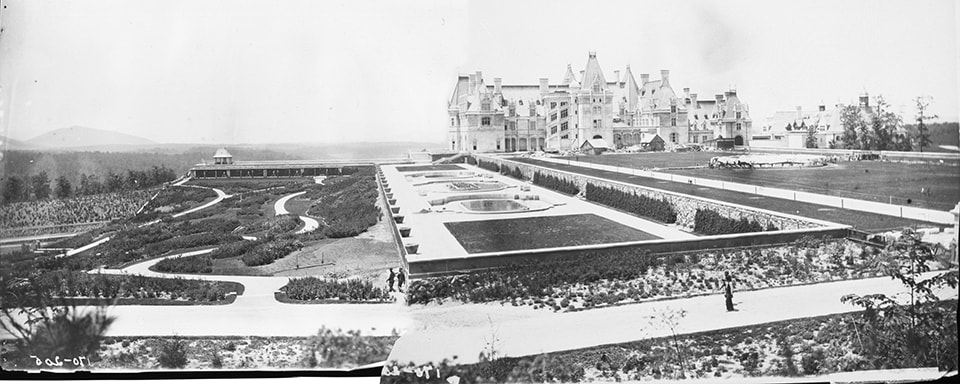
Biltmore house and the gardens: From north (right) to south (left): the esplanade, the water garden, the ramble, and barely visible below the slope, the productive garden, providing vegetables and flowers. A pine plantation is visible behind the productive garden. The gardens were intended to be a ”small park” and a “small pleasure ground and garden” – a clearing in the woods. (Images courtesy of the Frederick Law Olmsted National Historic Site, collaged by author)


The Biltmore Estate

In 1888, George Washington Vanderbilt II began to assemble 6,000 acres of hilly land along the French Broad River, near Asheville, North Carolina, intending to create a French-style chateau surrounded by formal gardens and large parklands beyond. Vanderbilt intended Biltmore to be a true estate — self-supported by agriculture, timber, and other productive landscapes — and he hired Olmsted for the commission. At sixty-seven, Olmsted was the nation’s foremost landscape designer, and had significant experience in park and garden design as well as in scientific forestry and farming. At Biltmore, Olmsted found an exhausted landscape, severely degraded from previous uses, and he proposed forestry as a means of ecological restoration, material and economic productivity, recreation, and education. Olmsted advised his client,

“The soil seems to be generally poor. The woods are miserable, all the good trees having again and again been culled out and only runts left. The topography is most unsuitable for anything that can properly be called park scenery….Such land in Europe would be made a forest; partly, if it belonged to a gentleman of large means, as a preserve for game, mainly with a view to crops of timber. That would be a suitable and dignified business for you to engage in; it would, in the long run, be probably a fair investment of capital and it would be of great value to the country to have a thoroughly well organized and systematically conducted attempt in forestry made on a large scale. My advice would be to make a small park into which to look from your house; make a small pleasure ground and garden, farm your river bottom chiefly to keep and fatten live stock with a view to manure; and make the rest a forest, improving the existing woods and planting the old fields” [2].


The soils had been depleted from logging, fires to clear land, farming, and pasturing animals. Much of the steep land had eroded, and soils had washed away [3]. Olmsted proposed forestry to stabilize the land, improve the soils, provide profit for his client, and also provide a model of experimental forestry for the nation.

Biltmore Estate, Asheville, NC

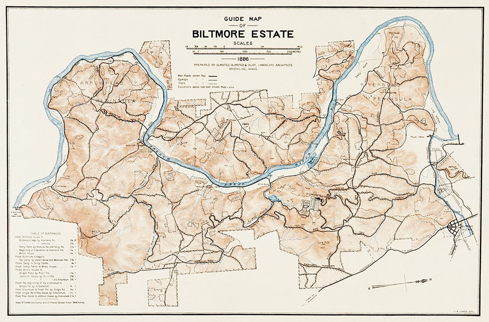
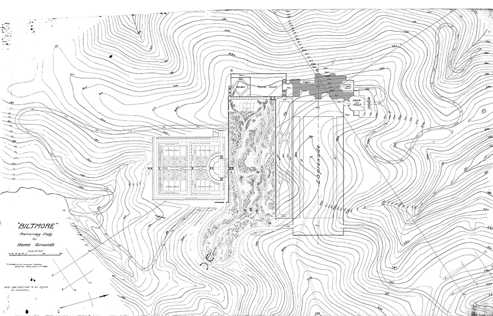
Plan of the Biltmore Estate in 1896: The house and gardens are middle right, and a 300-acre nursery is on the right (north) bank of the Swannanoa River (the smaller river on the north edge of the property). The majority of the property, then approximately 8,000 acres, was given to forestry. (Image courtesy of the Frederick Law Olmsted National Historic Site)


Scientific Land Management

Throughout his career, Olmsted proposed landscape architecture as an ameliorative practice to improve the productivity of sites. He began his career as a scientific farmer, and proposed scientific forestry in California in the 1860’s. In the emerging profession of landscape architecture, Olmsted saw a need for rigorous scientific inquiry to ground the wise management of landscapes.

Biltmore was not Olmsted’s first forest commission, nor his first proposal for scientific land management. Rather, it was a chance to realize ideas that he began developing in Central Park, his first landscape design. In 1876, Olmsted wrote to the president of the Central Park Commission to propose that the park operate as a form of forestry laboratory. The first trees had been planted there eighteen years earlier, and Olmsted proposed recovering the weather conditions, maintenance regimes, and tree health for that period, and tracking that data into the future, saying that “it will be regarded as a matter of some national interest that such a record should be made and hereafter presented and continued. The Central Park would then form a Museum of Arboriculture arranged and catalogued suitably for profitable study” [4]. However, the park board did not act on Olmsted’s recommendation, and it would require private, not public lands for Olmsted to enact his vision of a national forestry laboratory.

In 1880, Olmsted designed Moraine Farm in Beverly, Massachusetts as a 275-acre scientific farm with a 75-acre experimental forest, both intended to advance an American mode of productivity. Over 60,000 larch, pine, spruce, and birch were planted as an experimental forest, determining which trees produced the best timber yields on degraded New England soils [5].

Private landownership meant that he could implement long-term projects, and design by cutting trees as well as planting. By 1889, about the time he began work on Biltmore, Olmsted had become so frustrated with his inability to effect scientific forestry in his large park projects that he wrote, with J. B. Harrison, Observations on the Treatment of Public Plantations, More Especially Related to the Use of the Axe, a pamphlet intended to educate the public on the necessity of thinning and removing trees.

The same year, in his report to Vanderbilt, Olmsted wrote, “as the undertaking now to be entered upon at Biltmore will be the first of the kind in the country to be carried on methodically, upon an extensive scale, it is even more desirable than it would otherwise be that it should, from the first, be directed systematically and with clearly defined purposes, and that instructive records of it be kept” [6]. Having witnessed visitors to Central Park attempt to “wrest the axe from the hand of the woodsman” in planned campaigns of thinning the thickly planted woods, planning a scientific forest on private lands must have seemed a rare opportunity to Olmsted [7]Biltmore Productive Pines

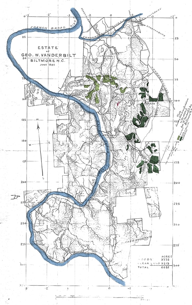
Productive Pines:  In 1892, the property encompassed approximately 7,000 acres. The light green shows pine plantations from the winter of 1889/90 (86 acres), dark green shows plantations from winter 1890/91 (169 acres). These plantations occurred before Pinchot was hired, and concentrated as they are in the viewshed of the house, they seem to be both ameliorative (for the soil) as well as aesthetic, creating the sense of a clearing in the woods. (Images courtesy of the Frederick Law Olmsted National Historic Site, collaged by author) 

Gifford Pinchot, the man Olmsted selected to oversee forestry at Biltmore, was at the time a young and inexperienced forester; the first (and at the time only) U.S.-born, trained forester; an ambitious twenty-six year old with a national vision for forest productivity and conservation. Pinchot saw a lax attitude in the United States towards natural resources, and he championed the nascent conservation movement, calling for governmental protection, on the European model, of natural resources from corporate abuse.

By 1890, Pinchot had studied forestry for a year at the École Nationale Forestière, in Nancy, France, and had spent months observing the forestry works in the Sihlwald forest in Zurich and on a tour of German forests led by one of the world’s preeminent foresters, Dietrich Brandis. His observations of the Sihlwald and on European forest policy had been published in Garden and Forest; although young, he was one of the nation’s leading experts on forestry [8].

Pinchot’s father James was a friend of Frederick Law Olmsted. Both were members of the same social clubs and professional associations, and they shared an interest in forestry [9]. Knowing of the work at Biltmore, James encouraged Gifford to apply to Olmsted for the position of forest manager; Gifford familiarized himself with the property, and approached Olmsted with preliminary suggestions for the land. In December 1891, Pinchot was hired to oversee the forest at Biltmore.

Biltmore Openwood

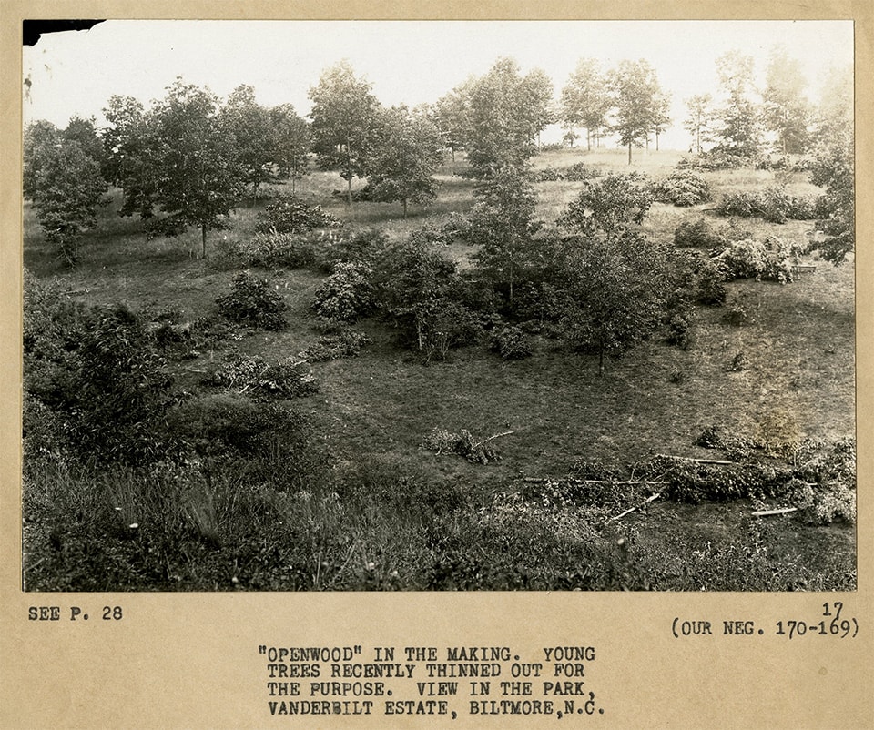
Forestry at Biltmore included both selective thinning of extant forests and planting in open fields. Here, young trees have been thinned for an open wood. (Image courtesy of the Frederick Law Olmsted National Historic Site)


The Biltmore Forest Proposal

Pinchot intended a steady yield of timber from the forest. At the time, wood was needed for heating, for industrial furnaces, for fence, wagon, and building construction, for road and railroad construction, and for naval shipbuilding. American forests were being rapidly consumed for construction, for fuel, for development, for agriculture. Pinchot had toured forests in thirty-three states, and seen what he later described as the “absolute devastation” of most logging practices, which reflected the common perception of forests as having a single use — timber — and extracted the greatest one-time value from them, without considering either the time required to get the forests to their then-current state, nor made any provisions for their future growth [10].

America needed forests that could produce dependable, sustainable yields of timber. Pinchot also saw the need for synthetic forestry that expanded beyond simple timber benefits. His approach was grounded in resource conservation, and took nature as its guide. This was perhaps learned from Brandis, whose mid-nineteenth-century forestry has been called “proto-ecological,” as he understood the forest as an environment, with links between species and disturbance events [11]. Pinchot used this ecological approach in his own work; he saw a healthy forest as one with a broad distribution of tree ages, with trees close enough together that they would encourage straight growth, but far enough apart that they could be felled. Pinchot’s improvements and harvesting techniques were inspired by nature. Group cuts mimicked blowdowns, a natural form of clearing in the wood that encouraged young trees to sprout. Linear cuts mimicked tornadoes, but were limited in length to protect the forest, and typically ran east-west to minimize drying the forest floor.

At Biltmore, Pinchot sought to prove that logging and forest management were not incompatible, and that productive forestry could be profitable. His three goals for the Biltmore forests were to generate profit; be self-sustaining; and improve the health of the forest. He proposed a phased plan, first improving the existing forests by thinning poor stands, promoting natural regeneration and fencing out livestock that grazed on young trees, along with extensive planting. The first, poor-quality harvests would occur over six years, with an eventual 150-year harvest cycle that used a hybrid of two traditional forestry practices — high-forest harvest and selective harvest.

In high-forest harvest, land was divided into sections equal in number to the number of years for mature harvest. Each section contained even-aged trees, and the sections were sequentially harvested and replanted, with harvest returning to the first section after the prescribed number of years. In selective harvest, the entire forest was logged annually, felling only those trees of sufficient maturity. The latter method was more difficult, in terms of ground covered annually, selecting trees to fell, and preserving the remaining trees, but it resulted in an ecologically healthy, mixed-age forest. Biltmore’s hybrid method harvested 1/5 of the property over five years, creating a 25-year harvest cycle, in a high-forest rotation. But as in a selective harvest, only trees over 130 years of age were harvested, all others left to continue growing [12]. Pinchot published the physical and economic results of the first years’ work in a pamphlet distributed at the Chicago Columbian Exposition, a report that Garden and Forest called “a most important step in the progress of American civilization” [13].

Pinchot proved that the forest could be simultaneously materially, economically, and ecologically productive. In addition, Olmsted and Pinchot envisioned several other innovations: an arboretum, a nursery, and the nation’s first, albeit short-lived, school of forestry at Biltmore, which was implemented by Pinchot’s successor at Biltmore, Carl Schenck. The arboretum was to display both ornamental and forestry trees, while the nursery provided trees and shrubs not only to Biltmore itself, but to landscape projects around the country. (In a planting plan where the entry road alone contained over 5,000 rhododendrons, an on-site nursery made a great deal of sense.) The nine-mile-long linear arboretum was to be planted along one of the roads, with trees “classified and arranged for study,” to be “an Experiment Station and Museum of living trees” [14]. While the arboretum never reached Olmsted’s vision, the 300-acre nursery was one of the top nurseries in the country, and in fact the world, for twenty years [15].Biltmore Pine Plantation

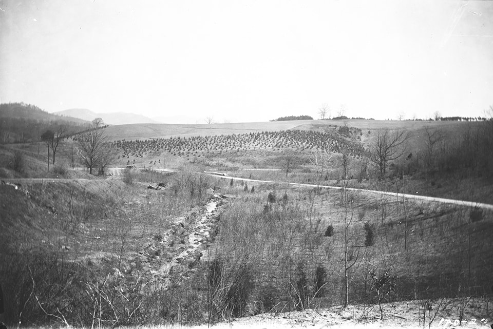
A pine plantation along one of the hillsides will grow in to create a frame for the new carriage road. (Image courtesy of the Frederick Law Olmsted National Historic Site)


The National Conservation Conversation

Although a private estate, Biltmore reflected Olmsted’s conservation ethic, a polemic that spanned his career from his early work on Central Park, through his campaigning for a national park system, and in his park designs for natural monuments such as Yellowstone and Niagara Falls. In the same 1876 letter to the Central Park Commission president that had outlined a Central Park forest laboratory, Olmsted had written that “the conservation of Woods and Forests…will soon be [a subject] of great national concern….Our sources of supply for all productions of the forest are rapidly shrinking, while the demand for them on the whole is prodigiously increasing” [16]. He went on to describe the benefits of forestry on deforested lands, and to explain the difficulty of scientific observation of forestry, due to the long time span of trees.

Olmsted believed that extraordinary lands should be preserved as public lands in support of a Jeffersonian ideal of a physically and politically healthy citizenry. State and national parks, Olmsted felt, should be reserves against the “false taste, the caprice or the requirements of some industrial speculation of their holders” that could result from the privatization of lands in the westward expansion [17].

Like Olmsted, Pinchot saw the management and use of the nation’s landscapes and natural resources as an issue of social justice. “The conservation issue is a moral issue, and the heart of it is this: For whose benefit shall our natural resources be conserved – for the benefit of us all, or for the use and profit of the few,” he asked young, politically ambitious men in 1910, before encouraging them to enter politics as a way to effect a more socially just natural resource policy [18]. Pinchot’s utilitarian philosophy, in which he sought “the greatest good of the greatest number in the long-run,” addressed the social ills resulting from industrialization. His was a modern forestry: scientific, functional, efficient.

Where most Americans saw a conflict between forest conservation and timber extraction, Olmsted and Pinchot saw the two as coexisting — healthy forests could produce useful timber. Like Olmsted’s scientific farming, Pinchot’s forestry was based in an understanding of edaphic and biotic ecological systems, and sought to optimize production of a crop or service through interventions into the processes of these systems.

To manage or to protect? This disagreement between preservation and conservation spanned Pinchot’s life and continues today. While on the National Forest Commission, Pinchot clashed with botanist Dr. Charles S. Sargent, director of the Arnold Arboretum, and founder of the influential weekly publication Garden and Forest [19].  Sargent believed that the national forests should be preserved as wilderness; Pinchot believed they should be managed productively for multiple services and functions. Pinchot’s diary entry on the dispute reads, “Sargent opposed to all real forest work, and utterly without a plan or capacity to decide on plans submitted. Meeting a distinct fizzle” [20]. This dispute continued in the famous disagreements between Pinchot and John Muir, and indeed continues today in discussions of the desired future condition of a forest and what cultural uses we want or need therein.

Olmsted’s firm agreed with Pinchot. Olmsted’s partner, Charles Eliot, wrote in Garden and Forest in 1897 about the need to manage forests, not simply protect and preserve them. Speaking against the “all too prevalent feeling that nothing can justify the felling of a tree,” Eliot wrote, “unless this superstition can be put to rout, we may as well attempt no parks or reservations, for if the axe cannot be kept going, Nature will soon reduce the scenery of such domains to a monotony of closely crowded, spindling tree trunks” [21]. Clearly, the Olmsted firm believed, as Pinchot did, that for forests to provide a social and cultural benefit, they must be managed, not merely protected.

Biltmore Forest School

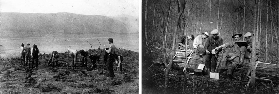
Along with timber and nursery stock, the forests at Biltmore produced knowledge. Here, Biltmore Forest School students establish a plantation along Coxe Ridge [Left], and measure logs and estimate yields [Right]. (Images courtesy National Forests of North Carolina Historic Photographs, D.H. Ramsey Library, Special Collections, University of North Carolina at Asheville)


“How Shall the Use of the Axe be Guided?”

The Olmsted firm instilled their work, and that of the larger profession of landscape architecture, with the new understanding of forestry processes tested at Biltmore. Olmsted had told his son, Frederick Law Olmsted, Jr. (Rick), that “Your school for nearly all wisdom in trees and plants and planting is at Biltmore” [22]. When, in 1895, Rick became a partner in the Olmsted firm, he brought to the firm extensive knowledge from his education at Biltmore: horticultural and nursery knowledge, forest composition and management, and the financial aspects of the nursery trade and forestry. As the most influential landscape architecture practice in the United States in the first half of the twentieth century, the Olmsted firm’s approach to forestry filtered out to the larger profession of landscape architecture even as it influenced their own design of urban park systems, university campuses, and civic monuments.

Yet even as scientific forestry infused the Olmsted practice, the two professions began to distance themselves and stake out their disciplinary turf. A debate played out in the pages of Garden and Forest. In 1897, Charles Eliot asked the question, “how shall the use of the axe be guided?” An earlier editorial had proposed that public parks require expert knowledge and maintenance of trees and forest, often through thinning, and that Americans “object on general principles and on all occasions to cutting down a tree;” forests in parks throughout America were severely neglected and their trees in very poor heath as a result [23]. Eliot conceded that foresters — “experts,” — must be “engaged at least as teachers of technical methods,” but argued that the work of foresters needed to done within the framework of a designer’s long-term vision, staking public parks as the domain of the designer. “But how shall the experts themselves be guided?” Elliot asked. “Shall they be permitted to reduce the groves and woods of our public domains to collections of specimen trees, or to the monotony of the typical German forests, as, by the way, they surely will do if they are not controlled?…Engineers who direct the building of park roads are expected to conform their work to the requirements of the adopted general plan. Woodmen, foresters and planters should be similarly controlled by the requirements of the same plan” [24].

Similarly, and in the same venue, Pinchot sought to define his field as a distinct profession. In 1895, he wrote polemically:

“Forestry deals exclusively with forests — a fact which will bear a good deal more publicity than has been accorded to it hitherto. It is connected with arboriculture and landscape art only from the fact that it employs to a certain extent the same raw material, if I may use such a figure, but applies it to a wholly different purpose. That the subjects overlap at certain points is therefore true, but so do carpentry and the manufacture of wood-pulp paper, yet there is no confusion between them. That wise forest-management secures the natural beauty of a region devoted to it is a fortunate accident, but none the less an accident, pure and simple. The purpose of forestry is in a totally different sphere” [25].


With the dawn of the twentieth century and the first mature stirrings of modernism, professions began to differentiate themselves and to lose the “disposition to ready and cordial cooperation between these branch professions … desirable for the public interests” that Olmsted Sr. had called for a decade earlier [26].

Biltmore's Three Natures

 The ramble, walled garden, and esplanade and water garden represent three natures: wild, productive, and perfected. They are a treatise on the nature of nature, carved out of the woods. To create the sense of a clearing in the woods, the forests around the house and gardens had to be re-established through plantations. (Images courtesy of the Frederick Law Olmsted National Historic Site, collaged by author)


“Ready and cordial cooperation”

For a few brief years, at the end of Olmsted’s career and the beginning of Pinchot’s, landscape architects and foresters spoke the same language, worked the same problems. Olmsted was, in Pinchot’s words, “one of the men of the century,” [27] a great pre-professional, synthetic designer who knew no professional boundaries and whose projects hybridized aesthetics, infrastructure, ecology, social justice, and economic productivity. Pinchot, one of the giants of his generation, carving out a new profession in America, was an early champion of the modernist value of elegant efficiency. Biltmore occupies a key temporal moment, situated at the emergence of a mature modernism.

Olmsted’s Romantic ethic and aesthetic informed his definition of and attitude towards nature. And his generation valued broad, synthetic knowledge. Farmer, journalist, landscape architect, sanitation secretary — Olmsted practiced across a range of fields. Yet he regretted his lack of deep, scientific training. He appreciated his son’s work for the U.S. Coast and Geodetic Survey as a way to learn “topographical common sense,” and urged his study at Biltmore as a way to “establish the names of plants in your memory and attach ideas, figures, pictures to these names….No one here [at the Olmsted firm’s Brookline office] has done half enough of this” [28].

Pinchot, meanwhile, fully embraced this optimistic, modernist faith in scientific knowledge, and advocated for specialized training and professionalization. Olmsted and Pinchot were both seminal figures in the professionalization of their fields, and by the end of Pinchot’s career, one’s practice was rapidly becoming one’s profession, with associated training, and increasingly, examination and licensure. This undoubtedly led to more rigorous, deep practice, in all environmental design and stewardship fields. But it also distanced fields from one another, and Pinchot’s modernist, utilitarian praxis has led to forests “like well-managed orchards” [29]. Biltmore suggests ways to recover some of the deep roots of “ready and cordial cooperation,” and perhaps suggests the urban forest — complex, enmeshed in social and cultural processes, and long neglected by foresters and conservationists alike — as the site for deeper cross-disciplinary engagement and collaboration.

One of the lessons of Biltmore concerns time. Forests — as crops, as a collection of species, as habitats and systems — have time frames well beyond that of a human life. At H.J. Andrews Experimental Research Forest, in Oregon, researchers are nearing the fourth decade of a 200-year-long log decomposition experiment. Because of the duration of forest systems, we still do not understand, fully, scientifically, something so seemingly simple as decomposition. How can we act in a system whose fundamental processes we do not understand?

At Biltmore, the Olmsted firm designed for at least a century, and designed with what ecologist John Magnuson calls “the invisible present” of growth, succession, and decay, as well as the invisible present of modernity and professionalization [30]. Pinchot managed the Biltmore forests for timber yields, which may not be our primary desire for most urban forests. But his choreography of the forest across space and time, accounting for trees, water, animals, and people as actors, provides lessons for today’s designer. The invisible present includes agents of change: climate change and invasive plants and insects that stress or eliminate some tree species; animal browsing or human maintenance that eliminates entire next generations of seedlings; cultural desires that limit the robustness of the forest.

A second set of lessons from Biltmore relates to collaboration between fields, and design for multiplicity. Olmsted wanted the Biltmore forests to produce nursery stock, pleasure, economic return, improved soil, and education. Pinchot described various ways that a forest could be useful: environmental protection of water and soil; material production of timber, nuts, habitat; monetary production as an investment. Both saw the forest producing professional knowledge and political agency. Olmsted and Pinchot pushed each other to imagine more. To see a forest as only ecological, only aesthetic, only economic limits our capacity for invention, while collaboration between fields expands our sense of possibility.

Biltmore Before & After

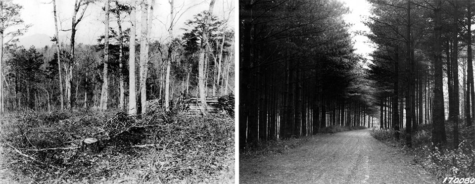
Before: The woods at Biltmore when Vanderbilt purchased them were generally of poor quality, requiring thinning and replanting [Left].
After: Forestry prescriptions such as “coppice under standards” were used to generate sustainable yields of timber from the property. A mature white pine forest on the estate [Right]. (Images courtesy National Forests of North Carolina Historic Photographs, D.H. Ramsey Library, Special Collections, University of North Carolina at Asheville)

And a third lesson of Biltmore is to recognize what Elizabeth Meyer calls “sites of invention.” Olmsted and Pinchot saw the devastation of extant forests, and they fought to set aside large tracts of land and to establish methods for managing those tracts. The threatened site of extant forests fostered the invention of the conservation movement and national forests. Today we find ourselves in a different context, with new challenges and opportunities. We have already had our national conversation about those large forests, and they have been placed, appropriately, under the long-term care of foresters, not landscape architects. We are still trying to truly understand urban forests, and here is where we need to apply our understanding of both cultural and ecosystem values, of both urban and forest composition, structure and function, of recreation and arboriculture, in a synthetic and interdisciplinary way. The urban forest is a contemporary site of invention, and it is here that professional collaboration may hold the most promise. At Biltmore, the two men dealt with a degraded, eroded, depleted landscape. While rural in setting, it had challenges common to an urban site, and forestry offered them an ameliorative, productive practice. We may find the same to hold in the urban forest.

Both landscape design and forest design are simultaneously hopeful and futile acts. They deny the lie of the master plan, with designs that set processes in motion. They envision a future condition that will likely never be, but set the stage for a new design in the next generation.

Many cities are currently inventorying their urban forests, a critical first step to a forest management plan. Foresters, planners, and designers are repeating in cities what Pinchot did at Biltmore: quantifying the benefits of the forest, and providing a baseline against which to measure improvements or failures. Concurrent with these metrics, we need a national conversation on how and why we value the forest. In Pinchot’s era, the forests in the United States were open for development, and very much under threat. Pinchot and Theodore Roosevelt set aside over 160,000,000 acres of national forests, a staggering public trust of beauty, habitat, and ecosystems services. What is the public trust we will leave for the future?


Roxi ThorenRoxi Thoren is an associate professor in the departments of architecture and landscape architecture at the University of Oregon. Prior to joining the UO, she practiced architecture and landscape architecture in Boston, Charlottesville, and Philadelphia. She is the author of Landscapes of Change, to be released in fall 2014, in which she examines innovative landscape architectural strategies that respond to new social and physical contexts. Professor Thoren is the Director of the UO’s Fuller Center for Productive Landscapes, which investigates the integration of productivity in landscape architecture design, including most recently a series of projects around forestry.


Notes

[1] Gifford Pinchot, Breaking New Ground (Washington, D.C.: Island Press, 1972), 32.
[2] Frederick Law Olmsted to Frederick J. Kingsbury, January 20, 1891, Frederick Law Olmsted Papers, Manuscript Division, Library of Congress, Washington, D.C.
[3] Bill Alexander, “Biltmore Estate’s Forestry Legacy,” Forest Landowner, January / February, 2011.
[4] Frederick Law Olmsted to Henry G. Stebbins, February 1, 1876, in The Papers of Frederick Law Olmsted, Vol. VII: Parks, Politics, and Patronage, 1874-1882, ed. Charles E. Beveridge et al. (Baltimore: The Johns Hopkins University Press, 2007), 175-6.
[5] “A Modern Massachusetts Farm,” Garden and Forest, March 30, 1892, 145-6.
[6] “Project of Operations for Improving the Forest of Biltmore,” no date, Biltmore Estate Archives, Asheville, NC.
[7] Frederick Law Olmsted and J. B. Harrison, “Observations on the Treatment of Public Plantations, More Especially Related to the Use of the Axe,” in Forty Years of Landscape Architecture: Central Park, eds. Frederick Law Olmsted, Jr. and Theodora Kimball, (Cambridge: MIT Press, 1973), 362-75.
[8] For Pinchot’s essays on the Sihlwald, see Garden and Forest vol 3, issues 127-129; for European forest policy, see vol. 4, issues 150-152.
[9] Nancy P. Pittman, in “James Wallace Pinchot (1831-1908): One Man’s Evolution toward Conservation in the Nineteenth Century” (Yale F&ES Centennial News. Fall 1999, 5) describes James Pinchot and Olmsted’s membership in the exclusive Century Association. Olmsted and James Pinchot’s friendship is described in the USDA’s  Historic Structures Report: Grey Towers (United States Department of Agriculture, Forest Service. FS-327, 2) and in Laura Roper, FLO: A Biography of Frederick Law Olmsted (Baltimore: Johns Hopkins University Press, 1973), 418-19.
[10] Gifford Pinchot, journal entry August 11, 1937, in The Conservation Diaries of Gifford Pinchot, ed. Harold K. Steen (Washington, DC: Island Press, 2001), 174.
[11] Dan Handel, “Into the Woods,” Cabinet, 48 (2012/13).
[12] Standard forestry practices are from US Department of Agriculture, Bureau of Forestry, A Primer of Forestry. Part II: Practical Forestry, by Gifford Pinchot, Bulletin 24, part 2, (Washington, DC: Government Printing Office, 1905). Biltmore forestry practices are from Gifford Pinchot, Biltmore Forest: An Account of its Treatment, and the Results of the First Year’s Work, Chicago: Lakeside Press, 1893.
[13] “Mr. Vanderbilt’s Forest,” Garden and Forest, February 21, 1894, 71.
[14] Frederick Law Olmsted, “George W. Vanderbilt’s Nursery,” Garden and Forest, December 30, 1891, 615.
[15] Charles E. Beveridge, “’The First Great Private Work of Our Profession in the Country’ Frederick Law Olmsted, Senior, at Biltmore,” National Association for Olmsted Parks Workbook, 5, no. 3 (1995), and Bill Alexander, The Biltmore Nursery: A Botanical Legacy, (Charleston, SC: History Press, 2007), 11.
[16] Frederick Law Olmsted to Henry G. Stebbins, 1 February 1876, in The Papers of Frederick Law Olmsted, Vol. VII: Parks, Politics, and Patronage, 1874-1882, ed. Charles E. Beveridge et al. (Baltimore: The Johns Hopkins University Press, 2007), 175-6.
[17] Frederick Law Olmsted, “Preliminary Report upon the Yosemite and Big Tree Grove” in The Papers of Frederick Law Olmsted, Vol. V: The California Frontier, 1863-1865, ed. Victoria Post Ranney et al. (Baltimore: The Johns Hopkins University Press, 1990), 488-518
[18] Gifford Pinchot, address to the Roosevelt Club of St. Paul, Minnesota, June 11, 1910.
[19] M. Nelson McGeary, Gifford Pinchot: Forester – Politician (Princeton, NJ: Princeton University Press, 1960), 39.
[20] Gifford Pinchot, journal entry May 16, 1896, in The Conservation Diaries of Gifford Pinchot, ed. Harold K. Steen (Washington, DC: Island Press, 2001), 72.
[21] Charles Eliot, “Trees in Public Parks,” Garden and Forest, January 27, 1897, 37.
[22] Susan L. Klaus, “’A Better School Could Scarcely be Found’ Frederick Law Olmsted, Junior, at Biltmore,” in The Olmsteds at Biltmore: Frederick Law Olmsted, Senior, eds. Charles E. Beveridge and Susan L. Klaus, (Bethesda, Md: National Association for Olmsted Parks, 1995).
[23] “Trees in Public Parks,” Garden and Forest, Dec. 23, 1896, 511.
[24] Charles Eliot, “Trees in Public Parks,” Garden and Forest, January 27, 1897, 37.
[25] Gifford Pinchot, “The Need of Forest Schools in America,” Garden and Forest, July 24, 1895, 298.
[26] Frederick Law Olmsted, “Paper on the Back Bay Problem and Its Solution,” in The Papers of Frederick Law Olmsted: Supplementary Series Vol. 1 Writings on Public Parks, Parkways, and Park Systems, eds. Charles E. Beveridge and Carolyn F. Hoffman (Baltimore: Johns Hopkins University Press, 1997), 437-460.
[27] Pinchot, Breaking New Ground, 48.
[28] Charles E. Beveridge, “’The First Great Private Work of Our Profession in the Country’ Frederick Law Olmsted, Senior, at Biltmore,” National Association for Olmsted Parks Workbook, 5, no. 3 (1995)
[29] Alan G. McQuillan, “Cabbages and Kings: The Ethics and Aesthetics of New Forestry,” Environmental Values 2 (1993): 205.
[30] John J. Magnuson, “Long-Term Ecological Research and the Invisible Present,“ BioScience, 40, no. 7, (1990): 495.

Urban Forests As Landscape Artifacts

“The foresters and their allies begat conservation and multiple-use.  The architects and their allies begat regional planning.  Together, the two offspring begat geotechnics.”

– Benton Mackaye, From Geography to Geotechnics [1]


“the history of this discovery [of the forest as a unique ecological type] is a separate and as yet unwritten chapter in landscape studies. It starts with a legal definition, more than a millennium ago, of the forest as a political space, a space with its own special law.”

– JB Jackson, “A Pair of Ideal Landscapes” [2]


The relationship between landscape architecture and fields such as planning and horticulture has historically been important and productive in the making of urban landscapes. Selecting and arranging specimens and species into formal compositions for aesthetic or ecological effect, or positing a landscape project as a generative and organizational structure for urban networks are practices that can be seen in the work of historical and contemporary figures ranging from Beatrix Farrand and Roberto Burle Marx to Piet Oudulf and Michael Van Valkenburgh Associates. Yet there exists an equally deep, though often ignored, relationship between landscape architecture and forestry [3].  What might be recovered or created if contemporary landscape architecture were to turn toward forestry, both learning from the practices used to sustain and study forests, and contributing to the shape these might take in the city? By understanding forests as an urban landscape type, we may find new sites of resistance to the city’s consumption-driven processes, and a more resilient and adaptive ecology that encourages active participation by people.

The multiple-use mandate of the US Forest Service offers a robust conceptual and technical framework for understanding and engaging the critical social and ecological issues facing cities today.  The multiple-use mandate was originally developed to manage large woodland tracts located far from population centers.  In the context of a city, addressing local issues necessarily entails grappling with a wider range of cultural values and social forces than forests in rural areas typically accommodate. By drawing on landscape architecture’s history of integrating and hybridizing social and environmental processes in cities it might be possible to recover and refine the conceptual tools needed to make this translation.

We propose that landscape architecture should work to adapt the multiple-use mandate of the US Forest Service to contemporary city conditions. If urban forests are understood as a multiple-use landscape type operating locally at a variety scales, they may present an alternative for negotiating some of the issues facing today’s cities. To that end, we examine the mechanisms of the multiple-use mandate and some of its historical antecedents; suggest four concepts that might be useful in adapting it to the urban context.

Davis&Vanucchi_Nebraska Natl Forest

The Nebraska National Forest: this aberrant landscape of evergreens in the sandhills of Nebraska was established in 1902 as an experiment to see if forests could be created in the treeless areas of the Great Plains for use as a national timber reserve.  This effort, anticipated by the work of landscape architect Horace Cleveland, resulted in a 20,000 acre forest, the largest human-planted forest landscape in the United States.


Beyond Parks 

Most public landscapes projected in cities today tend to be understood as one of four popular landscape types:  plaza, park, garden, or promenade.  Of these landscape types, park is by far the most promiscuous.  The search for an appropriate response to contemporary public landscape issues often results in an effort to make parks do more.  This typological tendency is problematic because the park is a landscape type that conjures a set of fairly specific compositional techniques, images, and experiences—all of which have their own potentials, limitations, and their own history.

Traditionally the power of parks has been their ability to fulfill two functions, simultaneously driving urban development while offering a respite from some of its effects such as traffic, noise, pollution, or the lack of access to green spaces. Municipal park-making as an urban practice rose to prominence as cities were undergoing explosive growth through an excess of industrial production [4].  Designers such as Frederick Law Olmsted and Horace Cleveland imagined parks as a way to contrast and combat the ills generated in industrial capitals in the 19th century [5].  The urban park resulted from a finely tuned set of techniques and methods of construction and composition such as creating strolling promenades or points of prospect.  These were intended to contrast the filthy, disease-ridden, ever-expanding industrial city with a sanitized view of the woodlands and fields that it replaced. Through this reconstruction parks became a public form of the aristocratic pleasure ground [6].

American park-making was seen as a way to organize the development of the city in ways that were beneficial to political elites and those rich enough to take part in the real estate market.  Whether such class sentiments were reflected in the intentions of the designers is highly debatable, but as Rosenzweig and Blackmar argue in their book The Park and the People, park-making has been intertwined with real estate development from the beginning [7].

In some instances these competing urban agendas have been resolved with a certain grace. Olmsted’s emphasis on the unique geological or topographical features of a site meant places identified as ideal parklands were often the most difficult places to build housing. Sites that were difficult to build on were turned into parks that fulfilled important social and environmental functions while adding value to the surrounding real estate [8].  The power of Olmstead’s ideas and the clarity with which he presented them have given Olmsted a legacy as the father of American landscape architecture and the great champion of park-making.  And yet, a closer reading of Olmsted reveals a much more rigorous and subtle landscape typology at work.

The plan for the Buffalo Public Landscape System called for five large public spaces, only one of which was a traditional park:  the Park, the Parade, the Asylum [9], the Cemetery, and the Front.  His biggest and best known work in Boston was known as The Fens, and his work at the Biltmore Estate in western North Carolina laid the groundwork for the creation of modern forest landscapes.  There Olmsted convinced the wealthy industrialist George Vanderbilt to forgo the creation of a large park-like landscape and instead hire the young forester Gifford Pinchot to implement reforestation protocols across a huge region that had been subjected to massive deforestation. Much of the former estate now forms the Pisgah National Forest.

For Olmsted the distinction went beyond names–his landscape interventions were not simply themed parks but in fact were fundamentally different landscape types that responded to different contexts and performed specific social and environmental functions [10].  The subsequent false equivalence of urban landscape-making with park design has resulted in an impoverishment of landscape architectural practice. Parks, with their emphasis on a fairly narrow range of recreational uses, privilege a specific set of cultural values that aren’t always appropriate in contemporary cities where ever-changing social dynamics and shifting economic climate place demands on public landscapes that fluctuate on different time scales.

Emphasis on the social and cultural aspects of landscape-making have enabled the creation of enduring and appropriate modern landscape types related to the park.  But continued development in this vein has yielded proliferation of leisure-parks for wealthy cities, with riverfronts and former industrial sites everywhere being papered over and commoditized as social experience ready for consumption.  Meanwhile, one sub-current in the practice of landscape design seeks to grapple with infrastructural landscapes [11], while another intends to expand the agency of the inhabitant [12], enabling everyone to make their own place, if only for a moment.  A focus on material practices of production is one method that adds some steel to these well-intentioned impulses and enables the construction of new forms, programs, and landscape types.  And the multiple-use mandate of forests is a tool for pursuing this.

Davis&Vanucchi_Buffallo

Plan of Olmsted’s Buffalo System: labels of the major open spaces have been enlarged by the authors; note the names of the different landscapes, indicating a rich landscape typology for the city; plan created in 1914 by the Buffalo Parks Commission, from City of Buffalo Library.


Multiple-Use Landscapes: Beyond Consumption

In some cities today there are innovative and exciting projects organized around the idea of planting large numbers of trees. These are variously understood as efforts to improve quality of life, produce more wildlife habitat and increase ecological resilience, and construct green infrastructure, and are undertaken by local partners and municipal parks agencies. However, there are some important distinctions to make between these efforts and the approach of the US Forest Service [13].  The provenance of these efforts originates squarely within the tradition of park-making. This fact tends to orient them toward the paradigm of recreation and conservation and emphasizes the composition of pleasing scenery that contrasts with the aesthetic of working landscapes. Forests, construed from the beginning as a working landscape, rather than its antidote, offer an alternative.

In his anecdote on the foundation of modern forestry in the United States, Benton MacKaye noted that at the beginning of the twentieth century “each national forest contained much more than trees… Wood, soil, power, ore, the ‘big four’ resources, all were involved in one wide complex” [14].  For MacKaye forests were understood through a conceptual framework of multiple use with the ultimate objective of watershed management at the regional scale.  And while actual trees were a critical component of that, the forest itself was a much more complex and heterogeneous assemblage than an agglomeration of individual trees.

A US Forest Service forest is not merely a sum of all the trees in a given area, such as a city’s boundaries or a large rural tract. A USFS forest is a legal and cultural definition for a type of landscape that encompasses a variety of ecotones and constructions ranging from grasslands, marshes, wetlands and rivers to extraction facilities, experimental sites, campsites and shelters, offices, housing, and infrastructure in addition to stands of pine or quaking aspen.

The alliance of things that forms a USFS forest landscape is managed according to the multiple-use mandate. This framework is significant because it sets into dynamic relation the competing operative logics of a given landscape.  Contrast this to the single-use mandate of the National Parks Service “to avoid, or to minimize to the greatest degree practicable, adverse impacts on park resources and values [so as to] provide for the enjoyment of park resources and values…” [15] In a national park, everything including conservation is about providing recreation. It is important not to conflate national parks with municipal parks, but they are historically related, and they are similarly limited in how they might be managed to respond to changing environmental factors and accommodate an expanding or altered range of social interactions and patterns of use.

The exact interpretation of the multiple-use mandate has often shifted since it was originally formulated. In his keynote address at the 5th World Forestry Congress in 1960, then-chief of the US Forest Service Richard McCardle laid down a clear explanation of how the multiple use mandate was then understood [16].  The five major uses of forest land of the USFS were: 1) wood production, 2) watersheds, 3) grazing by domestic animals, 4) habitat for wild game and fish, and 5) outdoor recreation.  Interestingly, the current chief of the USFS, Abigail Kimbell, interprets the multiple-use mandate according to only four points:  managing forests for 1) clean water, 2) wildlife habitat, 3) healthy vegetation, and 4) recreation [17].  This history can be taken as evidence of its dynamic capacity to respond to changing demands.  That the mandate has proven to be malleable and adaptable to contemporary needs while maintaining a focus on core areas of concern related to watersheds is of particular importance when considering contemporary cities combating issues of environmental toxicity, rising sea levels and changing climatic patterns, as well as the need for local habitat provision and alternative forms of recreation.

Though the multiple-use mandate is interpreted contextually, there is always some component of material production and performance- providing habitat for game, energy production, timber harvesting, mineral extraction. Interpreted through this framework, urban parks similarly provide for diverse range of performance and service functions—from mediating stormwater and microclimate to providing active spaces of recreation and cultural production. However, these have traditionally been sublimated into the primary objectives of providing recreational space and improving real estate values [18]. This ability of parks is more a function of the inherent capacity of any landscape to perform and negotiate multiple competing functions than the conceptual framework of parks themselves. Whereas parks are consumptive- consuming resources and offering experiences for consumption- forests are fundamentally productive and pluralistic. Because of this they offer a promising avenue forward for public landscapes.


A Landscape Approach: Learning from Indigenous Geotechnics 

The origins of modern forestry practices in the United States point to Olmsted and Pinchot’s work at the Biltmore Estate. The earliest roots of this type of large-scale forestry are typically attributed to advances made in Germany and France in the 19th century when forests began to be managed with a focus on sustained, maximal yields [19].  While the technocratic foundation of US Forest Service management practices are largely derived from that lineage, there are earlier examples indigenous to the Americas that demand inclusion in the discussion as landscape architecture returns to forestry. These historical examples offer important conceptual tools for more fully developing a landscape approach to urban forestry that can resist the technocratic values of maximization and efficiency as well as the consumptive tendencies of the contemporary city.

In his book Changes in the Land, William Cronon showed that indigenous peoples of New England intentionally altered huge swaths of mosaic forests, managing them through burning, planting, and clearing to generate ideal conditions over time for a wide range of wildlife species essential to indigenous ways of life [20].  For these societies the landscape itself was an artifact resulting from a plurality of site-specific cultural practices. Similarly, historian John Stilgoe noted that orchards and woodlots were common landscape types both in the town and on farm in 18th century New England. For that society these were productive landscapes that were sometimes public and had their own temporal and material demands:

Men faced a difficult decision. If they planted locust trees in their windbreaks they could be almost certain to have fifty-foot-high screens within twenty-five years; the silver poplar, the chestnut, the elm, the European larch, the silver maple and the Norway fir all grow extremely rapidly too, sometimes as much as thirty feet in ten years if the soil is rich… In the face of acute shortages of firewood and building timber, the nation’s farmers slowly relearned the lessons forgotten in the decades of clearing [21].


In the schematics described by both Stilgoe and Cronon, there is a certain slowness at work, as knowledge and the fruits of labor are passed down and added to across human generations. Labor and knowledge transfer of this kind demands that humans engage the capacity of landscape to negotiate competing demands at multiple temporal scales in an ongoing process of landscape accumulation.

Through his study of the Bauré society Clark Erickson concludes that in the past, indigenous people of the Bolivian Amazon “invested more energy in domesticating entire landscapes than in domesticating individual plant and animal species.” [22] By managing flood dynamics of the river through the construction and maintenance of infrastructures. This simple assertion that the domestication of the landscape itself can be the primary object of human intention and work, and not a mere epiphenomenon or derivative, is revelatory when considering contemporary cities and closely parallels Benton MacKaye’s concept of geotechnics. Importantly, in each of these cases methods of control were incomplete or open-ended. Rather than attempting complete control of biological, geological, and hydrological systems in the landscape, adaptive methods were developed that emphasized ongoing work and collaboration with specific dynamics of the landscape itself.

These landscape practices and concepts anticipated contemporary concerns in landscape architecture and planning and suggest that contemporary designers and communities have much to learn from models and methods of older indigenous examples in North and South America. Rather than solely materializing human intent and technical knowledge, they engaged the capacity of the landscape itself for surprise, leaving a space for novelty and engaging it through adaptive management.

Davis&Vanucchi_Bolivian Causeway & Canal

Parallel causeways and associated canals covered with trees cut across the Bolivian savannah and connect raised forested islands in the Baures region of the Bolivian Amazon. Image by Clark Erickson [22]


Designing and Managing the Urban Forest Landscape

Currently most cities define the urban forest as the sum total of trees on public and private lands [23] (an agglomeration of trees) and discuss its function in broad categories like the environmental, social and economic. For example in New York, the Million Trees Project states this objective: “to bring the many environmental, health, social and economic benefits that trees provide to all facets of city life [by] creating 2,000 acres of forest on City parkland and other public open spaces by establishing new, ecologically healthy, multi-story forests.” Typical municipal goals for urban forests include increasing canopy coverage to certain percentages within specified timeframes.

It is telling that most describe the urban forest only in terms of its trees [24], and suggests that cities are missing an opportunity to conceptualize and manage the urban forest as a landscape, building upon the USFS model but adapting it for conditions that are particularly urban.  We propose an urban forest landscape type based on four major concepts:
1. The urban forest landscape is productive and pluralistic, and must consider multiple, competing and evolving uses and users

Applying the USFS model of forest management and the techniques of long-term rural landscape management across the wildly diverse mosaic of urban land yields exciting potential for the emergence of hybrid and novel working landscapes. Mandated multiple uses can be prioritized to address the most acute problems of the place, and this reordering alters both the design of the forest and how it is managed.  If reducing stormwater flows and increasing infiltration are a top priority, the forest might be managed to maximize canopy cover and vertical structure.  By contrast, managing to expand habitat for specific wildlife species might call for a heterogeneous mix of patches with variable cover, species and stand age classes. When multiple objectives are combined and ranked (e.g. reducing stormwater flows while increasing red tailed hawk habitat), hybrid forest types emerge, each with its own potential compositions, images and experiences.  In fact, the urban forest managed as a landscape might be dominated by treeless areas, such as recently cutover stands, meadow, canopy gaps and fenced sites undergoing soil management in preparation for planting.

Through their focus on material practices and productivity urban forests can much more actively contribute to how cities manage flows of materials like carbon, compostable waste, water and nutrients, and can be designed to foreground and accelerate specific desired performances.  Although industrial in scale of operation, the material flows of forests differ from conventional industrial processes in that they involve abundant and renewable resources. Their characteristic ability to operate according to rates and quantities tied to the ability of the forest to process and digest means that they do not result in over accumulation.  In this way, forests are productive systems that replenish rather than deplete urban ground [25].   And while timber production is a possibility, trees in cities have perhaps more potential to provide direct, smaller scale products and benefits to residents living nearby such as decreased home energy costs and a range of products including wood mulch, informal building materials, and food crops such as fungi and nuts.
2. The forest landscape operates locally at multiple scales

Urban forest landscapes have a unique relationship to the city. They are spatially distributed within the urban mosaic and always operate locally at multiple scales. Rather than obeying abstract logics such as building codes and profit margins, forests must respond to conditions adjacent and under foot. They must cope with specific site conditions such as the fertility, depth and percolation rate of the soil.  They must tolerate contaminants, pest invasions and browsing by local populations of herbivores. Operating within an urban environment often means working in tight spaces with compacted and nutrient-poor or polluted soils. As a response, building an urban forest might not begin with trees at all, but with the restoration or generation of urban soils, a long-term process that significantly affects the viability and growth rates of plantings [26].  Trees disperse according to wind, animal use and planting preferences and patterns and intercept storm flows from adjacent paved surfaces to reduce runoff across watersheds.  They provide pathways for movement for wildlife as part of a larger matrix connecting urban to rural.

Increasingly cities have become the venue for addressing complex issues like climate change, and some have taken the lead in studying and planning for how to achieve carbon balance at the local and regional scale. While technocratic infrastructures are centralized and standardized toward efficiency and single objectives, forests inside cities can help localize urban metabolic processes by sequestering carbon, purifying air, building soil, and recalibrating stormwater runoff, infiltration and evapotranspiration to nearer pre-development levels [27].  Increasing the amount of forest land cover measurably eases the burden on conventional stormwater infrastructure within an urban sewershed, and carbon-sequestering forests could help address a global issue in and around the city.
3. The artifactual forest is a product of cultural practices that accumulates value over time

Cultivating a forest in a city means creating favorable conditions for chosen outcomes over long periods of time, because of one fact: forests are slow.  Developing the urban forest as a landscape may have to be learned and practiced in each city over generations of politicians, managers and residents, as each new case brings a unique set of evolving spatial conditions, regional contexts, environmental and social factors and disturbance regimes.  This quality of ‘slowness’ also suggests that the urban forest (compared to other land uses) is relatively fixed in space.  Over time it accumulates resources, memory, and knowledge through generations that imbue the landscape with value, enabling it to function as a place of resistance against the consumptive impulses of the city and to impel urban redevelopment elsewhere [28].

Unlike other managed forests, urban forests must also be responsive to the needs and preferences of large numbers of local residents.  While potential forest benefits and services are prioritized at the municipal level, residents living nearby should be allowed to express their concerns and desires for both what the forest looks like and what it provides.  Some urban residents may be unfamiliar with and even fearful of densely wooded tracts.  Alternative forms of the forest landscape might be developed to respond to local values, encouraging emotional attachment to the forest as a respite within the city, a place for social interaction and a way to connect to a new home and country [29].  The urban forest landscape inspires attachment to place by extending the spectrum of outdoor sensory experiences and offering people an active role in its design.
4. Managing the forest as landscape leaves room for novelty and accepts disturbance

Disturbances and setbacks tend to be frequent in the urban context, and the impacts of drought, flood, windstorms, air pollution, and changing climate may be amplified because plants are living with increased stress due to difficult urban conditions.  Recovery post-disturbance via the introduction of a new cohort group of trees may be slowed by the lack of nearby seed source areas.  Both punctuated post-event and continuous monitoring and interventions by managers are needed, especially if performance targets are to be met.  An approach that adapts to change while allowing room for unintentional novelty yields diversity and helps promotes resilience given high levels of uncertainty.

Davis&Vanucchi_Gowanus Forest Symbiotic Frameworks1

Davis&Vanucchi_Gowanus Forest Symbiotic Frameworks2


Davis&Vanucchi_Gowanus Forest Symbiotic Frameworks3

 “Symbiotic Frameworks” speculated on the form and function of a future urban forest in the Gowanus area of Brooklyn, NY; pictured are the material operations that enable education and in-situ remediation of and creation of urban soils, allowing for large-scale reforestation in sync with primary education objectives; project by Cornell University students Emma Martone, Alex Reese, and Putu Dawkins as part of the Gowanus Forest undergraduate studio


The forest as an alternative model of urbanism

Urban forests point toward an alternative landscape type for the contemporary city.  Urban forests are multiple-use landscapes operating locally at multiple scales that resist the consumptive tendencies of contemporary urban life and offer a way to adapt to changing conditions and social values. The urban forest is heterogeneous across scales due to diverse, constructed and anomalous site conditions, changing mandates and priorities, expanding and contracting funding streams and day-to-day concerns of community residents.  It both resists and is resilient. Slow and local, it must abide by its own rates of change including those of growth and decay, but management of the forest must be highly adaptable, adept at foreseeing and navigating change as it comes from a variety of actors and agents.

The urban forest landscape can’t pretend to be ‘natural’; it’s a construction that emerges from factors on the ground and that relies on both ecological processes and accumulated human knowledge and ingenuity to survive. It marries the technical with the material and expands the range of social experience and ecological resilience. It can create meaningful interactions between the local landscape and those who live nearby, connections that Boris describes as “deeply grounded in an aesthetics of change over time and an ethics involving care of and engagement in one’s everyday urban landscape”.  Imagine coming upon a familiar urban landscape where wooded zones have suddenly been cut over, with new geotextiles laid down in striking patterns and bosques left standing to repopulate the ground while the cut material is fashioned by local community members into pedestrian bridges, bat houses and benches.  That public landscape is one in which community members see great change over time, and might actively change themselves.

Davis&Vanucchi_Gowanus Forest Phenotypic Plasticity

 “Phenotypic Plasticity” explored the possibility of an urban forest on the Gowanus Canal in Brooklyn, NY that is optimized to grow black locust cultivars for timber production and the creation of periodic public spectacle; project by Cornell University student Scott Kelly as part of the Gowanus Forest undergraduate studio


DavisBrian Davis (@faslanyc) is an assistant professor of landscape architecture at Cornell University. He teaches design studios as well as seminars on construction technology and Latin American landscapes. His research looks at the relationship between landscapes and water infrastructure, with a geographic focus in Latin America and New York State.


VanucchiJamie Vanucchi is an assistant professor of landscape architecture at the State University of NY College of Environmental Science and Forestry in Syracuse, NY.  The core of her teaching and scholarship is the design and performance assessment of urban landscape infrastructures including land/water interfaces and urban soils and forests. She is particularly interested in performative, generative and adaptive landscapes that operate with minimal or alternative inputs.


Notes

[1] Benton MacKaye, From Geography to Geotechnics.  (Urbana:  University of Illinois Press, 1968), 41.
[2] John Brinkerhoff Jackson,  “A Pair of Ideal Landscapes” in Discovering the Vernacular Landscape. (New Haven: Yale University Press, 1984), 47-48.
[3] Anne Whiston Spirn,  Uncommon Ground: Rethinking the Human Place in Nature, ed. William Cronon.  (New York: W.W. Norton and Company, 1996), 99-102.
[4] In Nature’s Metropolis and The Urban Revolution, William Cronon and Henri Lefebvre, respectively, illustrate the relationship between urban centers and their hinterland and explore the mechanisms that enabled the forging and strengthening of these relationships, including the ordering of landscapes and construction of infrastructure using capital-intensive policies and technologies during the 19th and twentieth century.
William Cronon, Nature’s Metropolis: Chicago and the Great West. (New York: WW Norton & Company, 1992).
Henri Lefebvre, The Urban Revolution. (University of Minnesota Press, 2003).
[5] Cleveland is an interesting figure alongside Olmsted as he also showed a tremendous interest in forestry as well as park-making; note that his famous treatise Landscape Architecture as applied to the wants of the West included a lengthy essay on forestry entitled “Forest Planting on the Great Plains.” Taken together these historical facts suggests that both Olmsted and Cleveland saw forestry and park-making as twinned strategies, part of a multi-pronged landscape approach in response to the new conditions of industrial urbanism.
H.W.S. Cleveland, Landscape Architecture, As Applied to the Wants of the West. (Chicago: Jansen, McClurg & Co., 1873).
[6] Kowsky, Francis R. “Municipal Parks and City Planning: Frederick Law Olmsted’s Buffalo Park and Parkway System,” Journal of the Society of Architectural Historical Vol. 46 (March 1987): p 51.
 [7] This can be seen in everything from Olmsted’s own Report to the Commission of Boston to the overheated exclamations about the High Line’s impact on real estate values in Manhattan’s Meatpacking District.
 [8] Frederick Law Olmsted,  “Boston: Parks and Parkways- A Green Ribbon” in Civilizing American Cities: Writings on City Landscapes, ed. S.B. Sutton. (New York: Da Capo Press, 1997), 221-225.
 [9] The New York State Insane Asylum is rarely discussed as part of the Buffalo Open Space plan of Olmsted and Vaux, and yet their representations clearly show that this landscape was considered together with the other recreational spaces as part of a landscape network.
 [10] Kowsky, “Municipal Parks and City Planning: Frederick Law Olmsted’s Buffalo Park and Parkway System,” 51.
 [11] Pierre Belanger,  “Landscape as Infrastructure,”  Landscape Journal 28 (2009): 79-95.
[12] for a good discussion of the importance of human agency and activism see Harvey, David, “The Right to the City” in The New Left Review, 53, Sept-Oct 2008, and also Purcell, Mark, “Excavating Lefebvre: The Right to the City and its Urban Politics of the Inhabitant” in GeoJournal, 58: 99-108, 2002.
 [13] For instance, NYC Million Trees effort is a collaboration between the City Parks and Recreation Department and the non-profit New York Restoration Department, Los Angeles’ Million Trees LA program is a collaboration between the city and a consortium of local non-profits and businesses lead by Tree People, and Philadelphia’s Tree Philly project is an offshoot of the City Parks Department, with support from local ngo’s and businesses.
[14] Mackaye, From Geography to Geotechnics, 28.
[15] “National Park Service Management Policies,” National Park Service, accessed January 16, 2014, http://www.nps.gov/protect/policy_section.htm,
[16] Richard McCardle, “The Concept of Multiple Use of Forest and Associated Lands- its Values and Limitations,” Unasylva 14 (1960). http://www.fao.org/docrep/X5397E/x5397e03.htm.  accessed Nov. 7, 2013.
[17] “The U.S. Forest Service – An Overview”, USDA, accessed November 7th, 2013,  http://www.fs.fed.us/documents/USFS_An_Overview_0106MJS.pdf, p 3.
[18] Kowsky, “Municipal Parks and City Planning: Frederick Law Olmsted’s Buffalo Park and Parkway System.”
[19] M. Agnoletti, J. Dargavel, and Johann, E. “The Role of Food Agriculture, Forestry and Fisheries“ in Human Nutrition, Vol. II, The History of Forestry, ed Victor Squire. (Oxford:  Eolss Publishers, 2009).
[20] William Cronon, Changes in the Land: Indians, Colonists, and the Ecology of New England. ( New York: Hill and Wang, 1983), 20-57.
[21] John Stilgoe, Common Landscape of America, 1580 to 1845. (New Haven: Yale University Press, 1982), 201-202.
[22] C.L. Erickson,  “The Domesticated Landscapes of the Bolivian Amazon”  in Time and Complexity in Historical Ecology: Studies in the Neotropical Lowlands, ed. William Balée and Clark Erickson.  (New York: Columbia University Press, 2006), 235-278.
[23] See Philadelphia’s Planning the Urban Forest document, http://planningpa.org/presentations10/planning_urban_forest_pres.pdf, accessed November 7, 2013; New York’s Million Trees Project, http://www.milliontreesnyc.org/html/about/about.shtml, accessed November 7, 2013; the Chicago Trees Initiative, http://www.chicagotrees.net/chicago-trees-initiative/, accessed November 7, 2013.  Atlanta’s approach begins to shift toward a landscape-based model that includes “soil and ecological based design”. See http://www.atlantatreecommission.com/atlantas-urban-forest/a-urban-forestry-model, accessed November 7, 2013.
[24] The average life expectancy for an urban street tree is 7 years, largely due to this assumption.
[25] see David Harvey’s concept of the “spatial fix” where ground is used up and contaminated by the overaccumulation of waste materials by forces of capitalism and associated industry and manufacturing.  Harvey, David Harvey, “Globalization and the “Spatial Fix”. Geographische Revue 2 (2001), 23–30.
[26] The lifespan of a tree ranges from 30-600+ years.
[27] See Lloyd’s Crossing infill project in Portland, OR for demonstration of this concept. “Lloyd Crossing Urban Design Plan”, Mithun, accessed Nov. 7, 2013, http://mithun.com/knowledge/article/sustainable_urban_catalyst/.
[28] See Douglas Spencer’s discussion of the work of Groundlab (Eva Castro and Alfredo Ramirez). There he notes that strong form in the ground plane builds a resistance to the incessant flexibility of the urban landscape, which is often posited as inherently good by landscape urbanists.  This is in keeping with some of the observations of Ignasi de Sola-Morales in his seminal essay “Terrain Vague.”
work of Douglas Spencer, “Groundlab,” Architectural Design 04 (July/August 2012): 82- 87.
[29] The significant social role of forests for immigrants is discussed by Marion Jay and Ulrich Schraml in their 2009 paper, “Understanding the role of urban forests for migrants – uses, perception and integrative potential.”
Marion Jay and Ulrich Schrami, “Understanding the role of urban forests for migrants,” Urban Forestry & Urban Greening 8 (2008): 283-294.

Building The Global Forest

Both physically and spiritually, cities need forests. As the etymology of the term ‘foris’ – meaning ‘outside’ – denotes, the forest was positioned conceptually and spatially as the city’s counterpart [1]. However, as landscape architects gain increasing influence over urban environments the forest is now entering the city and being interwoven with it.

Schools of thought such as Landscape Urbanism, Green Urbanism and Ecological Urbanism take the forest as an ideal model for the city. The analogy points to a future city that works as a mature ecosystem, a city that converts its linear and wasteful systems into closed metabolic loops to reach a relatively stable, resilient and symbiotic state. In response, New Urbanists tell us this future city-as-forest is neither possible nor desirable [2]. Where green space is gratuitous and works to dissipate density, they have a point, but Andres Duany’s insistence on organizing the city along a transect that has culture at one end and nature at the other arrests urban evolution in the 19th century.

Important as they are for deciding the degree to which the future form and function of our cities evolve, these debates are somewhat out of sync with the actual scale and reach of the contemporary city. If we accept that ‘the city’ is now a continuous system of global exploitation and not merely the morphology of various residential and commercial densities, then any discussion of the ‘urban forest’ means that we should also scale up our thinking and discuss the ‘global city’ and its relationship to the ‘global forest’. 

Weller_Global Forest Cover

Figure 1. Global Forest Cover 

The Global Forest

The Earth Policy Institute (2012) estimates that approximately 31% of the earth’s terrestrial area (four billion hectares) is covered with forest [3]. However, despite increased awareness of the benefits of forests in respect of carbon sequestration, ecosystem services and provision of habitat, deforestation rates remain disturbingly high [4]. Some deforestation is attributable to ‘natural’ causes, but most of it is caused by human activity and much of that activity occurs in nations bedeviled by poverty and corruption where tropical forests are central to any hope of global climate regulation and biodiversity preservation. Regional increases in forest cover have typically occurred in places, such as China, where extreme poverty has been alleviated. It was for this reason that at Copenhagen in 2009 US Secretary of State Hilary Clinton offered impoverished nations up to $100 billion annually to reforest their denuded landscapes [5]. But that was Copenhagen.

A recent report by the United Nations Environment Programme and the World Conservation Monitoring Centre states that only 7.7% of the world’s forests are currently protected within strict conservation categories [6]. These categories are: 1) Strict Nature Reserves, and Wilderness Areas, 2) National Parks, 3) National Monuments, and 4) Habitat and Species Management Areas. Sixty-seven per cent of the 742 ecoregions with some forest cover have less than 10% of their forest area conserved [7]. In addition to these four conservation categories, the International Union for the Conservation of Nature (IUCN), Conservation International (CI), and the United Nations (UN) recognize two additional categories, so-called ‘Protected Landscapes (modified landscapes of cultural, ecological and scenic value)’ and ‘Protected Areas with Sustainable Use of Natural Resources’. If these areas are taken into account, then 13.5% of the world’s forests are officially ‘protected’ [8].

When considering these quantities from a global conservation perspective, it is important to also take into account the degree to which the protected areas include a representative sample of global biodiversity [9]. Presently, protected lands for all types of habitat are unevenly distributed across 235 countries in 160,000 sites [10]. Taken as a whole, these sites constitute 13% of the world’s remaining habitat and represent little more than half of earth’s 867 ecoregions [11].

Weller_Global Protected Areas

Figure 2. Global Protected Areas (IUCN Categories 1–4)

The designation and management practices of protected areas are at the discretion of individual nations.  In their current fragmented and diminutive state the world’s 160,000 protected areas will neither conserve global biodiversity nor mitigate climate change, the primary ecosystem functions we now look to our forests to provide [12].  As the concept of pristine nature becomes increasingly untenable, new forms of protected landscape are necessary.

The world’s most substantial effort to increase protected areas is enshrined in the United Nation’s 1992 Convention on Biological Diversity (CBD) to which 192 nations (and the European Union) are parties [13]. Originally the CBD set a commitment to conserving ‘[a]t least 10 per cent of each of the world’s ecological regions’ [14]. At the 2010 conference of parties in Nagoya a new set of CBD targets, known as the Aichi Targets, were established. The Aichi Targets comprise 20 policy statements agreed by CBD parties to achieve the strategic goals of halting biodiversity loss by, among other things, safeguarding ecosystems, species and genetic diversity. Aichi Target 11 states that “by 2020, at least 17% of terrestrial and inland water areas and 10% of coastal and marine areas, especially areas of particular importance for biodiversity and ecosystem services, are [to be] conserved through effectively and equitably managed, ecologically representative and well-connected systems of protected areas” [15].  With regard to forests, the convention calls for the effective conservation of “at least 10% of each of the world’s forest types” by 2010 [16].

Weller_Loss of Forest

Figure 3. Loss of Forest Between 2000 and 2014 (orange) 

Given that currently 13% of the world’s terrestrial area is presently under some form of conservation protection, the CBD commitment only requires that another 4% be secured globally by 2020. Four percent may seem modest, but this depends on how you look at it. For example, 4% of the earth’s terrestrial surface is 5,932,000 km2: the equivalent of 1,739,589 Central Parks.

Secondly, the 4% must also be seen against the rate of ongoing habitat loss.  A recent report in Science [17] concluded that between 2000 and 2012 the world lost 2.3 million square kilometers of forest and only added 800,000: a net loss of 1.5 million (or 439,882 Central Parks).  Taking this loss into account, the global effort to reach Aichi Target 11 would require that the equivalent of 2,179,471 Central Parks be secured as habitat by 2020. This is nothing less than the largest landscape architectural project in history, and yet there is a conspicuous absence of design intelligence being applied to this problem.

Weller_x2179471

Figure 4.  The number of Central Parks required to meet Aichi Target #11 – 17% of global habitat legally secured and or reconstructed as protected areas between now and 2020 

Weller_x439882

Figure 5.  Between 2000 and 2012, the world lost 2.3 million square kilometers of forest and only added 80 million: a net loss of 1.5 million (or 439,882 Central Parks)


The Conservation Landscape  

The first important phrase in the text of Aichi Target 11 is that the 17% protected global habitat should be ecologically representative. According to the CBD, this requires nations to ensure that “protected area systems…contain adequate samples of the full range of existing ecosystems and ecological processes, including at least 10% of each ecoregion within the country.” [18] In some cases, particularly in the 34 designated biodiversity hotspots where the habitats of close to half the world’s plant and animal species are critically depleted [19], it is not possible to protect what no longer exists. In such cases Aichi Target 15 asks CBD parties to restore at least 15% of their degraded ecosystems.

Weller_Global Ecoregions

Figure 6. Global Ecoregions

In order to better understand the global situation, we have taken the 17% global target and mapped the results of its application to each of the 374 ecoregions that constitute the world’s biodiversity hotspots [20]. In almost all cases, there is a significant shortfall between habitat that is currently under protection (according to IUCN categories 1–6) and what would be required to meet the target. Reaching the global target of an extra 4% protected habitat would not be such an issue if it were achieved through the designation of large areas in parts of the world where it was economically inconsequential, but when Aichi Target 11 is applied at the level of individual eco-regions it implies, in many cases, massive restoration projects.

Weller_Biodiversity Hotspots

Figure 7. Global Biodiversity Hotspots x 34

The second crucial expression in Aichi Target 11 is that protected areas (either extant or created) must be comprised of well-connected systems. This means nations need to invest in the creation of greenways that connect fragmented remnant habitat with patches of new habitat across all the ecoregions comprising their territory. In addition to providing a range of ancillary ecosystem services and cultural benefits, the primary rationale for such connected systems is to provide a means for plant and animal species to migrate and adapt to climate change over time. Because these connections need to cater for different species and because they will typically cross a range of existing incompatible land uses and boundaries (including national or subnational jurisdictional boundaries), they become particularly challenging design problems.

Weller_IndoBurma

Figure 8. The Indo-Burma Hotspot, an example of mapping undertaken at the University of Pennsylvania. The bar graph shows the shortfall between the current amount of protected habitat (IUCN categories I1–4) and the 17% Aichi Target.  The ‘fact sheet’ includes a list of active threats to habitat and population projections for major urban growth centers in the hotspot. 

Weller_Terrestrial Ecoregion

Figure 9.  An example of mapping the ecoregions of one hotspot, in this case the Indo-Burma hotspot. The two tones of green adjacent to each ecoregion show the amount of remnant habitat in the ecoregion (IUCN categories I-VI) and the shortfall between this and the 17% Aichi Target.

While much important scientific work is being done to document the conservation value of hotspots and identify imminent threats to their unique biodiversity, little attention has been applied to specific spatial planning of green infrastructure networks that would meet the targets [21]. According to the CBD, parties should all have ‘National Biodiversity Strategy and Action Plans’ (NBSAPs) in place by 2015. The CBD reports that, to date, 178 of the 192 nations party to the Convention have NBSAPs, but our (desktop) research found that only 12 of the 104 nations in the recognized biodiversity hotspots have any semblance of spatial plans that accurately designate land for protection and/or restoration [22].

Where spatial planning of large-scale habitat reconstruction and preservation does exist, it is typically conveyed in the form of maps with thick green lines drawn over vast territories with evidently little regard for existing land uses and ordinances. For example, in China, landscape architect Kongjian Yu’s unofficial ‘National Ecological Security Pattern Plan’ draws habitat reconnections on a vast scale according to the criteria of securing biodiversity, reducing desertification, and protecting water quality [23]. Admirable as this vision is, Yu does not shift scale to explain or illustrate how the appropriation of this extensive territory can be reconciled with existing landscape conditions and communities, or how any consequential loss of agricultural land would be offset.

 Weller_Integrated Map

Figure 10. A National Ecological Security Plan for China by Turenscape. Image courtesy Kongjian Yu

A similar example is the Pan European Ecological Network (PEEN). Emerging out of the European tradition of greenbelts and hedgerows, the PEEN is a trans-European network of ecological corridors and patches comprising 17 sub-networks. Reserving land for habitat in Europe is made possible by its largely post-industrial economy and agricultural surplus, but even so, Jongman et al. have reported considerable difficulty in achieving the requisite connectivity at both sub-regional and transnational scales [24]. The difficulty of achieving ecological networks in China (where centralized government makes almost anything possible) and in Europe (where there is relative wealth and political unification) does not bode well for more fractious territories. With their oft-heralded mandate of stewardship and interdisciplinary aptitude, landscape architects would seem well placed to lead teams to help nations meet the CBD targets by developing national plans for landscape preservation and restoration which are both “ecologically representative” and “well connected”.

In addition to preserving global biodiversity and protecting the ability of landscapes to function sustainably, the protection and regeneration of forested land has serious climate change implications. Peter Ward, Professor of Biology and Earth and Space Sciences at the University of Washington (Seattle), notes that current rates of deforestation contribute 16% of global carbon emissions. He writes, “[g]lobally nothing will help reduce carbon emissions more than planting trees.” [25] Similarly, after reviewing a range of highly technical and unpredictable geo-engineering concepts for mitigating climate change, famed author of the Gaia Hypothesis James Lovelock also recommends we immediately lock up all remaining habitat and plant more trees. However, as Lovelock explains, global reforestation cannot merely take the form of homogeneous plantations: we need to recreate forests with ecological complexity in order to maintain resilience into the future [26]. Given the impossibility of the literal recreation of complex ecosystems, we are then in the business of creating what Richard Hobbs refers to as “novel ecosystems” on a scale commensurate with the global ecological crises of climate change, deforestation and habitat loss [27].


Conclusion

Global policy settings such as the Aichi Targets offer a clear basis from which nations can negotiate the process of securing, reconnecting and reinstating habitat. But top-down policy will have little, if any, impact in politically unstable and impoverished parts of the world unless it is translated into the cultural and ecological specificity of place. As the maverick biologist Dan Janzen insists, the real work of restoration (as he has proven so convincingly with his own 165,000-hectare ‘garden,’ Area de Conservacion Guanacaste, in Costa Rica) can only be guided by the details of the site, its ecology and its society [28]. Janzen says we need to move beyond the image of pure wilderness and cultivate large areas of new wildlands as if they were gardens, places which have “all the traits that we have long bestowed on a garden – care, planning, investment, zoning, insurance, fine tuning, research and premeditated harvest.” [29]

By the same token, if restorative and protective efforts are left to piecemeal localized initiatives with no overarching planning that sets guidelines and regulatory frameworks for broad-scale connectivity and long-term futures, then the results will be at best fragmentary and ultimately unable to form the resilient large-scale habitat networks needed in the face of climate change. Similarly, if restorative landscape initiatives are planned for in a manner that is unrelated to the more powerful processes of urbanization occurring worldwide, then they will be vulnerable to the deleterious impacts of development. The future of rural landscapes, where restorative measures are crucial to biodiversity, has to be understood as connected to the dynamics of urbanization. As studies by the Yale School of Forestry estimate, there will be approximately another 120 million square hectares of land subsumed into urban development globally by 2030, and much of it in the world’s biodiversity hotspots [30]. The integration of urban growth with restorative initiatives to meet the Aichi Targets is the scale of operation required if the global city is to create a truly symbiotic relationship with the global forest.

Without the global forest, there will be no global city.


Credits

Mapping research and graphic production by Claire Hoch and Matt Wiener


Richard WellerRichard Weller is the Martin and Margy Meyerson Professor of Urbanism and Chair of Landscape Architecture at the University of Pennsylvania. Formerly he was Director of the Australian Urban Design Research Centre (AUDRC) and the design firm Room 4.1.3 known for the controversial National Museum of Australia. In addition to three books regarding his design and planning work, he has published over 70 papers on the intersection of ecology, art and design and given hundreds of public lectures around the world. Throughout his academic career he has received a consistent stream of international design competition awards at all scales of landscape architecture and urban design and was honored with an Australian National Teaching Award in 2012. Professor Weller’s current research concerns global conflict zones between rapid urbanization and biodiversity.


Tatum Hands

Tatum Hands is editor in chief of LA+ Interdisciplinary Journal of Landscape Architecture, produced by The University of Pennsylvania School of Design. Her current research involves evaluation of the legal and policy implications of landscape architectural scenario modelling in biodiversity hotspots. Before joining PennDesign, Tatum worked as a consultant to government in law and policy reform. She holds a degree in law and a Ph.D. in political science.


 Notes

[1] Robert P. Harrison, Forests: The Shadow of Civilization (Chicago: University of Chicago Press, 1993).
[2] Andres Duany and Emily Talen, Landscape Urbanism and its Discontents. Dissimulating the Sustainable City (British Columbia: New Society Publishers, 2013).
[3] UN Food and Agriculture Organization, “Forest Resources Assessment 201: Global tables,” (Rome, 2010), accessed at http://www.earth-policy.org/indicators/C56/forests_2012.
[4] M. C. Hansen, P. V. Potapov, R. Moore, M. Hancher, S. A. Turubanova, A. Tyukavina, D. Thau, S. V. Stehman, S. J. Goetz, T. R. Loveland, A. Kommareddy, A. Egorov, L Chini, C. O. Justice, J. R. G. Townshend, “High-Resolution Global Maps of 21st-Century Forest Cover Change,” Science 342, no. 6160 (2013): 850–853.
[5] Peter D. Ward, The Flooded Earth: Our Future in a World Without Ice Caps (New York: Basic Books, 2010), 206.
[6] United Nations Environment Programme World Conservation Monitoring Centre, World Wide Fund for Nature, Network World Resources Institute, Institute of Forest and Environmental Policy, and the University of Freiburg, Global Ecological Forest Classification and Forest Protected Area Gap Analysis: Analyses and recommendations in view of the 10% target for forest protection under the Convention on Biological Diversity (CBD) (Freiburg: Freiburg University Press, 2nd revised edition, January 2009).
[7] Ibid.
[8] Ibid.
[9] Convention on Biological Diversity (CBD), “Quick Guide to the Aichi Biodiversity Targets: Target 11,” http://www.cbd.int/doc/strategic-plan/targets/T11-quick-guide-en.pdf
[10] “The World Database on Protected Areas,” The World Database on Protected Areas, accessed 3/3/2014, http://www.wdpa.org
[11] Convention on Biological Diversity (CBD), “Aichi Target 11 Technical Rationale,” http://www.cbd.int/sp/targets/rationale/target-11/, (accessed 20 July 2013).
[12] Thomas Elmqvist, Susan Parnell, Michail Fragkias, Julie Goodness, Burak Guneralp, Maria Scewenius, Marte Sendstad, Peter J. Macotullo, Karen C Seto, Robert I McDonald, Cathy Wilkinson, Global Assessment of Urbanization, Biodiversity and Ecosystem Services (Springer, 2013).
[13] Only the Unites States, Andorra, South Sudan and the Holy Sea are not parties to the convention.
[14] “History of the Convention,” Convention on Biological Diversity (CBD), accessed 7/20/2013, www.cbd.int/history/
[15] Convention on Biological Diversity (CBD), “Quick Guide to the Aichi Biodiversity Targets: Target 11,” http://www.cbd.int/doc/strategic-plan/targets/T11-quick-guide-en.pdf
[16] United Nations Environment Programme World Conservation Monitoring Centre, World Wide Fund for Nature, Network World Resources Institute, Institute of Forest and Environmental Policy, and the University of Freiburg, Global Ecological Forest Classification and Forest Protected Area Gap Analysis: Analyses and recommendations in view of the 10% target for forest protection under the Convention on Biological Diversity (CBD) (Freiburg: Freiburg University Press, 2nd revised edition, January 2009).
[17] M. C. Hansen, P. V. Potapov, R. Moore, M. Hancher, S. A. Turubanova, A. Tyukavina, D. Thau, S. V. Stehman, S. J. Goetz, T. R. Loveland, A. Kommareddy, A. Egorov, L Chini, C. O. Justice, J. R. G. Townshend, “High-Resolution Global Maps of 21st-Century Forest Cover Change,” Science 342, no. 6160 (2013): 850–853.
[18] Convention on Biological Diversity (CBD), “Quick Guide to the Aichi Biodiversity Targets: Target 11,” http://www.cbd.int/doc/strategic-plan/targets/T11-quick-guide-en.pdf
[19] Russell Mittermeier et al., Hotspots Revisited: Earth’s Biologically Richest and Most Endangered Terrestrial Ecoregions (Washington DC: Conservation International and Cemex, 2004).
[20] Although the 17% target is a global one, for the purposes of the mapping exercise it was argued that ecoregions within the hotspots, being landscapes of critical biodiversity value, should be protected to at least the global target.
[21] Convention on Biological Diversity (CBD), “Cities and Biodiversity Outlook Action and Policy: A Global Assessment of the links between Urbanisation, Biodiversity and Ecosystem Services,” (CBD, Montreal, 2012), page 43, accessed at http://www.cbd.int/doc/publications/cbo-booklet-2012-en.pdf.
[22] The 12 nations within biodiversity hotspots that have published a spatial plan are Myanmar, India, Laos, Brazil, Sudan, Palau, Philippines, Papua New Guinea, Bolivia, Peru, Nicaragua and Georgia.
[23] Kongjian Yu, “The Bigfoot Revolution,” in Designed Ecologies: The Landscape Architecture of Kongjian Yu, ed. Saunders W. (Berlin: Birkhauser, 2012), 192–199.
[24] R. Jongman, Mark Kulvik and Ib Kristiansen, “European Ecological Networks and Greenways,” Landscape and Urban Planning 68 (2004): 305–319.
[25] Peter D. Ward, The Flooded Earth: Our Future in a World Without Ice Caps (New York: Basic Books, 2010), 206.
[26] James Lovelock, The Vanishing Face of Gaia: A Final Warning (New York: Basic Books, 2010).
[27] Richard J. Hobbs, Higgs, E & Hall, C, Novel Ecosystems: Intervening in the New Ecological World Order (Hoboken, N.J: Wiley-Blackwell, 2013).
[28] Daniel H. Janzen, “How to Grow a Wildland – The Gardenification of Nature,” in Nature and Human Society, eds. P. H. Raven and T. Williams (Washington D.C.: National Academy Press, 2000) 521–529.
[29] Daniel H. Janzen, “Gardenification of Wildland Nature and the Human Footprint.” Science 279 (1998): 334–335.
[30] Seto, Karen C., Burak Güneralp, and Lucy R. Hutyra. “Global forecasts of urban expansion to 2030 and direct impacts on biodiversity and carbon pools.” Proceedings of the National Academy of Sciences 109 (2012): 16083-16088.