Contemporary Infrastructure: An Interview With Marcel Smets

Ksenia Kagner (KK): In “The Landscape of Contemporary Infrastructure,” your recent book with Kelly Shannon, you collect a wide international array of built infrastructural projects. You argue that infrastructure, particularly mobility infrastructure, is a pivotal element in shaping urban and regional landscapes. Why do you think there is so much attention being paid to mobility infrastructure, to the extent that, as you say, “around the world, public authorities are seeing transportation infrastructure as their primary field of investment”?

Marcel Smets (MS): If you think about the way our cities and economies function, it is primarily through the movement of goods and services. Mobility becomes such an inherent part of urbanization that the quality of what we experience and what we can deliver is highly dependent on it. The real task of the body politic is to create a situation whereby people, inhabitants, citizens, can actually function in the best possible way. And perhaps then mobility infrastructure is one of the last avenues to make public investments in. I mean, if there is one task left somehow that the public hand needs to be in control of, it is actually the provision of amenities enabling people and services to move about. There is of course an ideological point of view: one could argue that many means of transportation are actually exploited by private companies. But even when this is the case, let’s think about what happened with airline companies. At the time when they are doing badly, governments, even the American government, step in to bail them out. Why is that? There is a clear understanding throughout all political parties, independent of political views, that if tomorrow airline transportation were to stop then this would have an enormous effect on our economies. Therefore, societies and their governments cannot afford for private companies to go bankrupt. It’s one of the primary ways for the State to oversee an economic process based on a general public consensus that does not apply to any other system or network as it does to mobility networks. Let me elaborate.

When you follow the health care debate in the United States about the infrastructure of health, one observes no clear public consensus on whether this is the task of the public hand. However, one doesn’t hear the same voices when major American airline companies go into Chapter 11 and are being supported by the State, or when budgets for highway improvements are being passed.

So, this general consensus that without mobility infrastructure we will not survive as an urban society secures and comforts me. This agreement on the necessity of public investments in the field of transport infrastructure is what brings Kelly Shannon and I to say that these investments offer a unique opportunity for urbanism and landscape urbanism to employ them as the basis for creating better environments in the city.

Leidshe Rijn Bridges. Utrecht, the Netherlands

KK: Would you say that the visibility of mobility infrastructure plays a significant role in this perception that mobility is a necessity and can imprint a large footprint on the urban landscape? Because mobility is more visibly present than a storm sewer line is it more economically lucrative for a government to invest in a very public way?

MS: It’s a difficult question because in my opinion other infrastructural networks are just as important. Can we imagine a contemporary urban society without the right stormwater and sewage systems? Or not debating about stormwater reuse and the ecological potential of water?. This is of course extremely important for urbanity and I would be the last to say that mobility infrastructure is more important. But other networks are more or less invisible and are taken more or less for granted.

Transport infrastructure is witnessed every day as an urban landscape. Even when it’s invisible, like metro systems, there is a direct urban response which is highly present in the cityscape. For instance, when metro lines meet and create a transport node, these nodes generate accessibility and clearly then influence real estate capacity above that node. The whole mushrooming development that we know in many cities—look at cities in Japan for instance—is so typical, that on a map of a city one can identify the underground nodes of transportation by simply looking at the height of the buildings. What happens underground becomes sort of a mirrored portrait of the urban landscape that is going to exist above it. In that sense even the invisible underground transportation becomes visible, whereas the underground sewage systems remain invisible. In this way it’s quite an obvious investment strategy for politicians to publically support a better transport system…

KK: Touching a bit further on visibility, your book is then broken into a four chapter taxonomy of how infrastructure relates to landscape. (1.Imprints of Mobility in the Landscape; 2.Physical Presence in the Landscape, 3.Perception of Landscape through Movement and 4.Infrastructure as Public Space) Through this behavior-based taxonomy, how then, does infrastructure influence the quality of the environment?

MS: The ambition of the book was to create a taxonomy which was globally applicable and which would be able to synthesize all the aspects with regard to infrastructure’s relationship to the urban landscape. When you consider the full meaning of the four elements you named, I am relatively confident we covered this ambition.

Now, I don’t think the taxonomy in itself influences the quality. It is a tool we used to discuss what is happening today, without prescribing guidelines or suggestions on how best to conceive of infrastructure. You could write another book which would aim to define urbanistic guidelines for a certain type of infrastructure—this was not our ambition. The book was an observation of what is happening today, trying to find categories which applied globally and look not necessarily for the best but for the most telling examples that convey an attitude. The book is really about the attitude which we as designers have today about conceiving infrastructure. In all the examples illustrated in the book, designers have the ambition to create quality and I leave it up to the reader to decide whether this has been attained. Even if in my opinion it is not always the case, it doesn’t mean that it’s not in itself an important attitude to take into consideration as a driving element of our thought today.

Let’s take one clear example—the commercialization of infrastructural space. Today, it is increasingly more difficult, if not impossible, to dissociate an airport and a commercial mall. In my opinion such evolution is quite detrimental, to be very honest. We can take two possible attitudes vis-à-vis this situation. One is to make the best possible mall, and the other is to attempt to gear the economic forces that turn mobility nodes into malls, into other kinds of profits that may offer more interesting civic spaces. To arrive at such a goal, we could try and expand the node into a realm that hosts other fluxes than movements of travel, a space that becomes wider and integrates the urban spaces that are used by ‘non-passengers.’ If we do so, it could lead to a commercialization in terms of real estate profits that might be higher than the ones generated by the commercial returns of the mall alone and still make better cities. What we try to do in the book is note the elements that are really determining how places are given form by designers or by the economic forces behind them. As such, it’s more of an inventory of projects to begin the discussion without being necessarily moralistic about it.

KK: And talking about new civic spaces of the 21st century, how can we as design practitioners foster more positive urban development around transit nodes and transportation infrastructures?

MS: Well, the position of designers is of course always a position of weakness, because they are not the ones deciding. However, when we consider the transportation node a standalone enclosed connection, most of the time it’s not municipalities that benefit from that, it’s the transport companies—public or private. Because on the most basic level, the land belongs to the company and so does the revenue associated with that land. But actually it’s only a small kind of gain. If the designer can convey to a municipal body that the effect of the node is much larger than just the crossing of the two lines, and that people are willing to cover (depending on the scale of the city) between 300-800 meters by foot around them – then the area of influence on which the transport node exerts potential revitalization becomes much larger.  So from the beginning it is essential that any kind of transportation project is not seen as just an amenity but as an urban project and includes in its design thinking an area larger than just the transport amenity. The gains will be much larger and spread through multiple parties.

For that reason, it is crucial for designers to take on the role of advisers of municipal bodies. As designers, I think our most basic strength is that of conviction.  And this strength of conviction lies in making a project. Through that project we can show that the collective gain will be much larger if the project covers what the Spanish used to call the ‘intermediate scale’ or ‘scala intermedia’. And this scale level is precisely where you have to forge a sort of consensus between the different interest groups in order come to a collective project with public spaces that will also provide economic benefit. And as landscape architects and urban designers we are exactly in the position to do just that.

KK: So landscape architects and urban designers are really the mediators?

MS: That is of course the complexity of our profession. That’s why the engineering professions are no longer able to oversee complex infrastructural projects. They are too specialized in partial aspects. If you don’t succeed in viewing the whole and taking up the role of mediators you will never succeed in generating collective agreement and hence collective improvement.

This is the greatness of our profession, besides being landscape and urban designers we are the lobbyists for the public realm, we try to weigh on the decision making process and we have always been interested in the history of our cities. We understand something very acute, which is that interventions of such scale are not standalone, self sufficient objects but rather are a part of city’s history. So these multiple roles are essential to the successful fulfillment of our profession.

Berlin Central Station. Berlin, Germany

KK: To participate in the international exchange via mobility infrastructure, a list of parameters must be met and certain set of rules to obeyed. Therefore, on one hand, mobility infrastructure facilitates the ease of access, while on the other hand, restricts it. How much of the thinking is about restriction of access? Can you identify any new patterns that have emerged as a result? What are their tangible consequences?

MS: You are pointing at something extremely important, at what the French economist and philosopher Francois Ascher calls the ‘right of mobility’. Mobility infrastructure should be accessible to all, but of course it isn’t. What we observe globally is that having access to mobility, particularly to super-mobility (i.e. the high-speed train, airplanes, etc…) is really a divisive element in our society today. The more that our cities grow and the more we are globally connected, the more we rely on transportation to exist and support our activities, the more this kind of social inequality becomes visible.

One of the most striking examples where this occurs is Rio de Janeiro, where right in the middle of the urban realm you have 200-plus favellas. It’s incredibly difficult for those inhabitants to access even the urban metro system due to difficulty of the geographic and topographic conditions. This applies to goods and services as well as people. In a city with a sophisticated public transport system you thus maintain a great divisive element that is through transport access. This is why we begin to observe an emergence of new infrastructural experiments notably in Brazil and Columbia of making urban escalators, for facilitating access to the public transportation. But then sometimes, people cannot afford it. So there is an enormous problem. The more sophisticated the public transportation gets the more inaccessible it becomes for certain categories of people. We are constructing a split society. One of the major tasks of public governments today is to erase this level of inequality.

The book doesn’t touch on this crucial problem. And somehow, it is the main task of our time. I am not convinced however, that a solution lays in massive investments, but rather in strategic investments. Many of our mobility systems exist independently and are not very well connected. How can we make better exchanges from one to the other?

For instance, in China right now they are building the largest high-speed rail network in the world. And when you look at how it’s conceived you see the creation of new stations and a brand new network that is in no way connected to existing railway, metro or bus systems. This kind of thinking reflects a typical efficiency concept of the 60s. As a result, you can go from Shenzhen to Shanghai in a short period of time, but you might spend more time getting to and from the high speed train station than the journey between the cities. We are still not thinking about transportation as soft and integrated systems, but as separate provisions. This is particularly detrimental because it risks augmenting inaccessibility further yet. So as designers we really have to reflect on the idea of transport being part of daily life and how can we organize a transport infrastructure that is not only considered in isolation.

KK: You note that while mobility infrastructure was originally a synthetic project that engaged traffic engineering with urbanism and architecture, it has become over-engineered. Newer theories such as landscape urbanism are positing the potential of public works to re-engage urbanism as well as natural systems. Why do you think we’re seeing the re-emergence of a multi-disciplinary approach to mobility infrastructure?

MS: Infrastructural projects of the 60s have failed to address the evolving needs of societies. These projects have become too complex to leave it to the engineers. They need to be addressed from many aspects in order to understand how best to find the right solution for these kinds of complex problems. Furthermore, the heightened sense of awareness for elements of sustainability, the survival of natural systems and the re-use of existing infrastructure, are all influencing the kind of proposals that are being considered in order to meet these objectives. I am thinking in particular about the motorway connection between Denmark and Sweden, the Øresund Link which consists of a tunnel and a bridge. If one analyzes the project closer, the reason for this hybrid is inspired by the sedimentation of the crossing sea arm. In this way the project, while providing for societal needs also preserves the natural habitat.

How to create an infrastructure that leaves nature more or less untouched is a first step. But in my view we are entering another phase, which is even more interesting: how can we create an infrastructure that organizes natural life. And it’s clear then that landscape architecture has become extremely influential in pointing at possibilities of reconsidering certain infrastructures in such a way that they would become the motor of a new evolution involving a new kind of a landscape dynamic. Fascinating! It’s these kinds of interventions today that are really the most innovative. There aren’t yet too many. Some of the interventions that claim to be landscape infrastructure appear perhaps a little bit formalistic in a sense that they rely on landscape forms rather than landscape dynamics. But once we are dealing with how to influence the water system and how does the habitat proceed in between the infrastructure, this is when we get to it being a motor of a new evolution. I sincerely hope that this will continue.

If the decision makers realize that by creating infrastructure they’d be able not only to guarantee accessibility, accessibility for all, but also restore natural systems and habitat, of course this would really be a gain. We have an obligation as designers today to reflect on those kinds of processes and to break away from classical models. We should not create objects that serve as machines in the park, but rather create an infrastructure that makes the whole park.

KK: To really begin to understand landscape as infrastructure one really must understand it as an evolving project over time. However, through the project inventory in the book, it appears as though in order to build a relationship to an infrastructure project one needs to objectify or to attach an icon or a monument to it. If infrastructure is a system not an object, what are the risks of objectifying infrastructure?

MS: It’s one of the great dilemmas of the landscape profession. If we consider landscape infrastructure as something in the long term, it becomes invisible. It is a structuring element, which means that the ultimate aim is not to be a visible form. The objective is to gear the environment around it over time. And this is something that is very difficult. Arguably, landscape architects are not fully trained for that. The conundrum of course resides with visibility needed to get future commissions for private practices, and the attention paid by the media.

It’s not as attractive to publish work that is relatively invisible and where the result would appear in 20 years’ time. We, collectively, often succumb to the temptation of making something formalistically attractive and attach perhaps too much importance to that. As a result of such thinking, the initial goal is at times transformed into objects that do not serve the purpose that they claim to serve. As designers we have to be cautious of that.

As an example of this long term thinking, Michel Desvigne’s work comes to mind. In particular, the Plateau de Saclay project outside Paris, for which Desvigne is doing a masterplan. He did a series of drawings which he calls “landscape information.” So how do you render a landscape in formation? By showing a sequence of plus 5, 10, 20 years ahead and how the project will evolve with time. This is particular to the profession of landscape that the real value of a project is put to test when the construction ends and the relationship with natural forces develops over time.

Øresund Bridge and Tunnel. Copenhagen, Denmark to Malmö, Sweden

KK: You and Ms. Shannon talk about the relationship between public transit infrastructure and surrounding private development. Is infrastructure inherently public? Should it be?

MS: Manuel de Solà-Morales wrote how the morphological richness of contemporary cities resides in the collective spaces that are not strictly public or private, but both simultaneously. These are public spaces that are used for private activities, or private spaces that allow for collective use, and they include the whole spectrum in between. A lobby of a hotel, for example, is a collective space but is not public. A railway station is an extension of the public realm but is privately administered.

What characterizes the sensation of a public space in my opinion is how Baudelaire puts it—is in the unexpected.  Past the airport security checkpoint one only meets passengers, and is in a compound of sorts, and as such it is collective but not public. The idea of creating space that allows other kinds of users to partake is highly essential. And if that can be attained, whether this space is ultimately owned by public or private bodies is perhaps of secondary importance. There should be in my opinion a certain collective common base, a public realm which somehow is accessible to everybody. How to get there in privately organized spaces is a task of our century…

 Interview with Marcel Smets

KK: In your role as State Architect to the Flemish Government, you’ve had a chance to observe and influence how large municipal infrastructure projects are made.  What do you think the role of designers should be in the conceptualization and realization of mobility infrastructure?

MS: As designers, the only empowerment we have is our conviction and our project. It’s through the project we can prove that more is possible than the client initially assumed, and that potentially there are other elements to the benefit of the client that haven’t been thought of. The State architect is the figure that is more or less emblematic for the ‘illuminated’ public client. The main duty is to create a system of decision making by which best possible projects are selected and that stimulates designers to create quality.

When I held this position, all public commissions went through a competition process. First of all, we tried to be extremely clear about the ambition and the intended quality requirements of the project. Clarity of the competition briefs is paramount. For infrastructure projects we asked a group of young and ambitious designers to make preliminary analyses which would help create the best possible brief. It is very difficult to understand what is possible in the abstract. As such, a thorough investigation is necessary to know what is attainable. Furthermore this process facilitates a discussion with the clients, as there is always more than just one client or one government. To get all city agencies to speak the same language is a preliminary project to the making of a competition brief. So we used design as a tool of investigation in order to create a consensus with the client body.

The selection process of the competition would then take place in two stages. The first stage would not base any decisions on cost but only on the quality of the proposals. The second stage would then expand the review to cost/quality. As it is very tempting for a public body to make a selection without considering quality and making its selection based only on price, it is important to have the first selection round based on quality independent of the price.

It took a long time, but this process was accepted. People slowly realized that in the long term these investments we so crucial that one could not afford a miserable job. It’s a long task but I think people like us do not only have a task to design and hope for the best, but we also have a task to see that we use our knowledge and our competence to provide our society with a greater general sense of urban quality. And that is achieved by influencing the decision making. So through universities, public offices and mandates, opinions and editorials in newspapers we can also exert an influence.

KK: Is it a good moment for the field of landscape architecture to reappropriate the domain of (landscape) infrastructure?

MS: Today, the intrinsic difficulty of creating an infrastructure project is to attain collective agreement from everyone involved. (By those in proximity with the NIMBY attitude; by the tax payers who think the project too expensive, by the environmental bodies that think it unsustainable, etc…) So an infrastructure project becomes a whole operation of decision making and consensus building. This is one of the reasons why transportation infrastructure created by engineers alone is absolutely no longer acceptable.

As landscape architects, we understand that accessibility for some often jeopardizes quality of urban spaces for others.  So in order to be able to come to a good decision, we need politicians to realize that they cannot just leave it to the engineers, and that landscape architects and urban designers are essential to attain collective feeling of improvement. Because in order to arrive to a collective agreement—you need a good project addressing all these aspects. And that is simply too complex for the engineering practice alone.

KK: What is the best course of action for empowering designers for this task?

MS: Interventions of certain importance in landscape urbanism require much more involvement in the process of preparing and getting people to agree than in the design. So we need to get involved in a complex task of administering our own briefs, our own work. Universities have a potential to address issues in strategic ways. Design studio reviews could invite decision makers and community stakeholders to show what is possible and begin planting seeds. We need to be citizens that are highly involved and that speak a similar language, and show that our dreams are not science fiction.


Marcel Smets is a professor of urbanism at the Katholieke Universiteit Leuven. He has been active in the area of history and theory with monographs about Huib Hoste and Charles Buls, as well as reviews about the development of the concept of green suburbs in Belgium and the country’s recovery after 1914. He has written articles of architectural criticism for publications such as Archis, Topos, Lotus, and Casabella, and has served as a jury member for many competitions. He was a founding member of ILAUD and visiting professor at both the University of Thessalonka and Harvard University’s GSD. He has also sat on the scientific commission of EUROPAN since its inception.

He was the chief developer of the widely publicized and highly praised transformation of the area around Leuven station, and for town planning projects which include Antwerp city center, Hoeilaart, Turnhout, Rouen, Genoa, and Conegliano. Currently, Smets’s research focuses principally on landscape and infrastructure.

Ksenia Kagner is a landscape practitioner based in New York City. Her work seeks to find the productive interplay between articulate detailing and natural systems. Ksenia holds a master of Architecture from McGill University and a Bachelor of Architectural Studies from the University of Waterloo.


The Next Generation Of Infrastructure

Intro

The next generation of urban infrastructure will not be built.  This is to say, that a sustainable future will not come from new technologies.  Urgent demand is already overwhelming adequate risk management and urban governance capacities.  While indeed carbon-free light rail, driverless cars and desalination plants will be in unquenchable demand, none of it will happen successfully without a bankable environment that aggressively manages the social, political, financial and environmental risks of new infrastructure.  The barriers to the next generation of infrastructure [1] are neither technical nor financial; rather they’re social and political.  Effectively responding to the unprecedented need for urban infrastructure hinges on the successful process over the high-tech outcome.

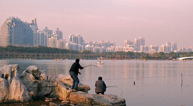
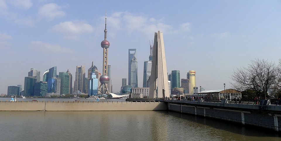
Shanghai waterfront

Shanghai, China. Image © Scott Muller

New Urban Dynamics

Cities have replaced national governments as the de facto drivers of global economic growth and human development.  In fact, 300 of the largest metro economies worldwide, containing just 19% of the world’s population, delivered nearly half of the global economic output in 2011 [2]. A recent analysis by the McKinsey Global Institute reveals that by 2025, more than two thirds of global GDP will be produced by just 600 cities – the majority of them in emerging countries [3].

But importantly, economic growth does not alone create stability.  Spanning from the least to the most developed, the fate of cities is one of increasing vulnerability to climate change, resource scarcity and rapid population growth.

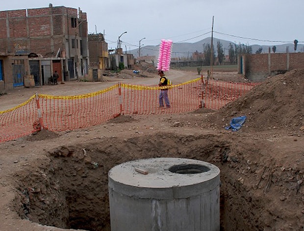
Chorrillos_Peru

Chorrillos, Peru. Image © Scott Muller

Hyper-Urbanization

By the year 2030 world urban population will increase to nearly 5 billion persons (1.35 billion more than present), increasing the planet’s urban area by an astonishing 150% in less than 20 years.  Sixty percent of the area to be urban by 2030 has yet to be built [4]. Contrary to the trend of the 20th century, the majority of this urban growth (and commensurate economic growth) will occur in developing countries and mainly in second-tier and lower cities. From now to 2030, the world will need to build the equivalent of a city of one million people in developing countries every five days.  Their intense demand for the rapid construction of new infrastructure threatens their already challenged risk management and urban governance capacities.


Nexus Issues

Incongruous to this rapid urbanization, is the reality that current growth is no longer supported by sustainable inputs, as we are already 50% in “overshoot.”  In other words, human systems are presently using 50% more than the annual productivity and assimilating capacity of the planet’s ecosystems [5]. This unsustainable consumption of ecosystem services to subsidize the growth of cities is progressing ever farther along the urban-to-rural gradient.   One result is an ominous energy-water-food nexus of demand confronting city, regional and national decision makers.

As urbanization reaches farther beyond its geopolitical borders to satisfy ever-greater metabolic demands, rural communities and families are linearly assimilated into “foreign” urban economies, with marked social and cultural impacts.  Families with rural legacies can be insurmountably challenged by joining an urban economy yet remaining spatially disconnected from services.  In the end, urban migration is more often not so much a quest for economic prosperity, as it is a survival strategy for the rurally displaced.


Climate Change

Continued urban development is made more complex by a third, interrelated, crosscutting element: climate change.  Increasing climate disruptions are changing the fundamental rules of city planning and administration.  Rapid climate change is altering both the risk (threats) and the fitness (responses) landscapes of cities.  Unfamiliar risks and new statistical criteria have rendered historical “business-as-usual” strategies increasingly ineffective and detrimental with direct implications on safety, quality of life and the economic performance of cities.  Uncertainty is now a fundamental core element of urban development, along with non-linear growth patterns, runaway positive feedback/ cascading failures, hidden thresholds and irrevocable tipping points.  The rapidly reshaping insurance industry is but one example of shifting solutions – with increased disaster intensities and frequencies, the utility of insurance to guarantee major new infrastructure investments becomes increasingly untenable.

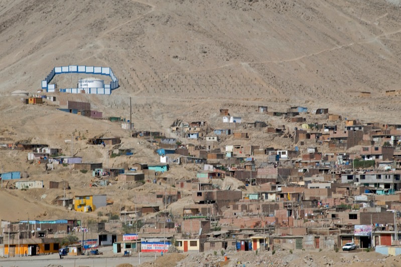
Manchay_Lima_Peru

Manchay, Lima, Peru. Image © Scott Muller

The Managerial and Policy Challenge

As urban economies mature in developing countries, and as cities become increasingly more vulnerable, their decision-making power is rising and yet becoming more complex at the same time.  The speed of urbanization and the new risk landscape present a profound managerial and policy challenge for municipalities.  Cities and metropolitan governments are now obligated to deal with exponential rates of urban immigration; protect and conserve the surrounding landscapes and ecosystem services sourced outside their geopolitical boundaries; ensure sufficient energy supplies for their industry and residents; finance, construct and maintain hard infrastructure; respond to the pressing challenge of sea level rise; attract private industry and foreign investment; negotiate with multilateral development banks (MDBs) and engage with foreign government official development assistance (ODA).

Spanning from the least to the most developed, the fate of cities is one of increasing vulnerability to climate change, resource scarcity and rapid population growth.  The fate of the world has become the fate of cities.  There has emerged with great immediacy, a revolutionary worldwide discourse on how to best make cities more sustainable: building resilience, enabling transformation and de-risking the economy.


Addressing Vulnerabilities

The thoughtful development and management of new infrastructure is a powerful way to de-risk cities.  But often overlooked in the speculative, investment driven rush to build, is the fact that infrastructure impacts the sustainability of urban systems in several ways; some of them less immediately apparent to elected officials.

Infrastructure’s impact on urban sustainability includes positive performance gains, but additionally, it can also create negative pathway dependencies and the commensurate loss of “optionality.”  However, thirdly and most importantly, the demand for urban infrastructure creates a unique circumstance – when often disparate socioeconomic groups briefly share an orbit around an issue involving a public good or a common pool resource.  This is a critical opportunity to generate and strengthen urban social capital – the key success attribute for the next generation of infrastructure.

Estimates suggest that US$ 53 trillion must be spent on infrastructure worldwide by 2030 to adequately manage the rapid growth of cities [6]. In 2011, the High Level Panel on Infrastructure for Recommendations to the G20 pointed out that the key constraint to infrastructure development is not a lack of funding.  After all, financing can technically be created to support low-risk investments. Rather, they identify the principal barrier to rapid infrastructure development as the absence of a strong pipeline of bankable projects [7]. This is to say, infrastructure projects must be low-risk to qualify as “bankable.”  Infrastructure in developing countries is an asset class highly vulnerable to political, regulatory and execution risk.  Therefore, managing the social, political, financial and environmental risk of infrastructure projects should be the priority when pursuing the performance gains of new infrastructure.

The most important investment a city can make today is developing integrated, cross-disciplinary capacity within the “infrastructure development process,” and the commensurate tools and methods to mitigate the social, political, and financial risks.  Building this systemic capacity allows successful urban development along a range of fronts, among them the “next generation” of infrastructure.

To create goal-seeking behavior towards sustainability and avoid the development of unsafe slums and unsupportable resource-intensive path dependencies, it becomes essential that all sectors of civil society have a seat at the table to participate in the selection, design, launch, management and perhaps ownership of infrastructure projects.


Collective Actions and Horizon Lines

Cities are Human-Environment Systems (HES), appreciably comprised of common pool resources and public goods.  These interact in ever-shifting equations to one day ostensibly arrive at an equitable, circular economy.

HES are considered to be complex adaptive systems because they consist of influential, interacting smaller systems that self-organize as a whole.  As they grow, the challenging issues of overuse and equity must continually be addressed.  More specifically, growing cities are subject to social dilemmas and the problems of collective action and inter-temporal resource allocation.  Collective action challenges in cities relate to the fact that individuals and subgroups make decisions based on particular desires without considering the impacts their decisions may have for others in society.  Inter-temporal resource allocation dilemmas involve individuals and subgroups making decisions locally in time (short time horizon, or equivalently applying a high discount rate) without considering the long term/ global consequences of these choices.

As a complex adaptive system, HES can demonstrate goal-seeking behavior.  So it is important to point out that the rapid expansion of cities is not impeded by the absence of adequate planning, transportation, housing, finance or attention to risks.  Rapid urbanization occurs whether infrastructure is planned or not; “electricity and cable are first stolen and later gentrified” [8]. To create goal-seeking behavior towards sustainability and avoid the development of unsafe slums and unsupportable resource-intensive path dependencies, it becomes essential that all sectors of civil society have a seat at the table to participate in the selection, design, launch, management and perhaps ownership of infrastructure projects.  Citizen access to and participation in public decision making, along with building coalitions and multi-sector partnerships will not only significantly increase the success of infrastructure projects, it will also unlock latent circular economies and subsequently advance the sustainability of the Human-Environment System.

Lima_Peru

Lima, Peru. Image © Scott Muller

The Renewable Power of Shared Learning

One method to efficiently enable integrated capacity and multi-sector collaboration along the infrastructure development process is by creating peer learning environments among municipal government officials as well as civil society.  Research demonstrates that the bottom-up accumulation of knowledge by professionals via peer-to-peer learning experiences is one of the most important factors in the types of projects and policies that make their way into successful strategic planning and policy proposals [9]. Peer learning builds capacities of all stakeholders and decision-makers, promoting effective functioning beyond a single project, including the next generation of infrastructure.

Over the past four years, the Institute for Sustainable Communities (ISC) has developed a methodology for creating shared learning environments, culminating in the organization of Sustainable Community Leadership Academies (SCLA) with the explicit purpose to accelerate urban climate adaptation and sustainability [10]. These intensive three-day academies bring together 10-15 multidisciplinary teams of 5 or 6 senior level practitioners and municipal government officials from cities and metropolitan areas.  To date, teams from more than 400 cities have participated in these Leadership Academies, generating a wealth of results, tools, and networks that can accessed by anyone.

This past April 15-17 in New Orleans, Louisiana, the Mississippi Sea Grant Consortium [11] and ISC kicked off an 8 month “Gulf Coast Community Resilience Program.”  Utilizing ISC’s peer-learning methodology, leaders from 6 Gulf Coast communities created an informal network to advance and accelerate resilience.  During the workshop, the practitioners shared experiences and tools, each identifying two to three key implementation ideas to apply in their communities over the summer.  Tailored technical assistance within the informal network will help the participating Gulf Coast communities apply their resilience implementation ideas.  In the fall, the same six communities will come together again for a follow-up Climate Leadership Academy (CLA) to share results and lessons learned, solidifying the informal network.

One highlight during the April CLA plenary was when Dr. Pam Jenkins of the University of New Orleans’ CHART [12] Program facilitated a community mapping clinic.  Using a structured process, each community team identified coastal adaptation initiatives that led to “therapeutic” or  “corrosive” communities.  For example, after the recent Deepwater Horizon Oil Spill, factions with differing interests and opinions on financial settlement options led to a “corrosive” community atmosphere.  On the other hand, after recent natural disasters, many teams sponsored “therapeutic” community celebrations that featured actionable dialogue on coastal adaptation strategies.  As a result of the clinic, community leaders now have the tools to foster therapeutic approaches for the design of climate-adaptive infrastructure choices.

Seoul, Korea. Image © Scott Muller

Internationally, another contemporary example of cities using peer learning to develop the next generation of climate-adaptive infrastructure is occurring in Southeast Asia.  ASEAN [13] cities are some of the fastest growing in the world, and yet at the same time, some of the most vulnerable to climate change – forcing more adaptive approaches to urban development.  As a result, city practitioners across the region are designing and building more resilient, ecologically integrated urban infrastructure, engaging their populations in inclusive decision-making, and collaborating across jurisdictions.  These activities are generating innovations and investment opportunities that are shaping growth throughout the region.  In a partnership between U.S. cities and ASEAN member states, ten teams of senior municipal officials from second- and third-tier cities will be participating in an SCLA on Urban Adaptation next August, [14] with a primary focus on sharing lessons of managing the social, political, financial and environmental risks of urban infrastructure.   After the SCLA, a selection of cities will participate in partnerships with U.S. Cities to gain more exposure to innovative approaches, good governance tools and appropriate infrastructure technologies.

The results of ISC’s Leadership Academies across diverse cities and broad geographical range, support the research that concludes shared learning environments and exchange among practitioners can effectively overcome information overload as well as resource constraints, spawning innovation and greatly increase the likelihood of policy transfer [15]. What’s more, peer learning affords practitioners the ability to not only learn from their colleagues, but also to teach them – offering a sense of empowerment.  Growing and strengthening the leadership capacity of these municipal leaders builds the overall profile of the profession – the resources generated from peer learning provides a core knowledge base for city sustainability practitioners and civil society organizations.


Going Forward

So while infrastructure is a key physical and technological asset of cities – representing critical capital investment – more important is the knowledge, shared ownership and collaboration that the next generation of urban infrastructure embeds in the Human Environment System.  Successful public infrastructure is a legacy to the surmounted social dilemmas, collective action challenges and path dependencies resolved leading up to its construction.

The next punctuated equilibrium will not come from advanced or new technologies.  Rather it will emerge from shared learning, multi-sector coalitions, integrated planning, public-private partnerships, the skillful advocacy of civil society and good governance.  This is how to best reframe urban development and economic growth to include the capacity of the biosphere.


Muller_headshotFor the better part of two decades, Scott has been incorporating strategies for sustainability into international development with specific attention to climate change, ecosystem services, urbanization, biodiversity, cultural heritage and renewable energy. Scott is the Senior Manager of the International Climate Program at ISC, working with local communities, municipal and national governments to respond to shifting “fitness landscapes” by building capacity to rapidly scale up urban sustainability and resilience.  From 2007-2012, Muller was the City Director for the William J. Clinton Foundation’s Climate Initiative (CCI) – C40 Cities Climate Leadership Group in Lima, Peru.

He can be reached at smuller@iscvt.org


References

[1]  The next generation of infrastructure is defined by its service to urban sustainability.
[2]  Metropolitan Policy Program, Global Metro-Monitor 2012: Slowdown, Recovery, and Interdependence. (Report, Brookings Institution, 2012).  Accessible at http://www.brookings.edu/~/media/research/files/reports/2012/11/30 global metro monitor/30 global monitor.pdf
[3]  McKinsey Global Institute, 2012.  Urban world: Mapping the economic power of cities. (Report, McKinsey & Company, March 2011) Available at http://www.mckinsey.com/~/media/McKinsey/dotcom/Insights and pubs/MGI/Research/Urbanization/Urban world mapping economic power of cities/MGI_urban_world_mapping_economic_power_of_cities_full_report.ashx
[4]  Seto, Karen C., Burak Güneralp, and Lucy R. Hutyra. “Global forecasts of urban expansion to 2030 and direct impacts on biodiversity and carbon pools.”Proceedings of the National Academy of Sciences 109, no. 40 (2012): 16083-16088.
[5]  Wackernagael, M. et. al. 2002. “Tracking the ecological overshoot of the human economcy.” Proceedings of the National Academy of Sciences. July 9, 2002 vol. 99 no. 14
[6]  OECD, Strategic Transport, Infrastructure Needs to 2030.  (Report, OECD, March 2012) ISBN 978-92-64-16862-6.
[7]  Thiam, Tidjane -Chairman. High Level Panel on Infrastructure, Recommendations to G20 (Final Report. 26 October 2011).
[8]  Brand, Stewart. Whole earth discipline; an ecopragmatist manifesto. Atlantic Books, 2010.
[9]  Marsden, Greg, Karen Trapenberg Frick, Anthony D. May, and Elizabeth Deakin. “Bounded rationality in policy learning amongst cities: lessons from the transport sector.” Environment and Planning A 44, no. 4 (2012): 905-920.
[10]  “Sustainable Communities Leadership Forum,” Institute for Sustainable Cities. Accessed 5/22/2013 at http://sustainablecommunitiesleadershipacademy.org/
 [11]  NOAA, “Home” Mississippi-Alabama Sea Grant Consortium. Accessed 5/22/2013 at http://sustainablecommunitiesleadershipacademy.org/
[12]  “Center for Hazards Assessment, Response & Technology,” University of new Orleans. Accessed 5/22/2013 at http://sustainablecommunitiesleadershipacademy.org/
[13]  Association of South East Asian Nations
[14]  “A Climate Leadership Academy on Urban Adaptation: From Risk Barrier to Results,” ICMA, CityLinks and USAID. Accessed 5/22/2013 at http://icma.org/en/cl/news/events/climate_leadership_academy
[15]  McCann, Eugene. “Urban policy mobilities and global circuits of knowledge: toward a research agenda.” Annals of the Association of American Geographers 101, no. 1 (2011): 107-130.

Skeleton Forms: The Architecture Of Infrastructure

As cities increase in scale and complexity, practitioners in design fields struggle to understand and direct the impact made by infrastructure on the urban environment. Since the early discussions of landscape urbanism in the 1990s, architects have looked outwards to other disciplines to provide clues for dealing with complex contemporary sites: for instance, to ecology’s ability to map and utilize dynamic systems and to landscape architecture for its ability to articulate a variety of ground conditions or address de-urbanizing and post-industrial sites, as exemplified by the Shrinking Cities projects [2]. While these fields have contributed significantly to our understanding of infrastructure at large, any architectural contribution to the discussion ought to draw upon the methodologies and strengths of the discipline.

For architects in particular, the definition of what might constitute an architectural approach to infrastructure remains somewhat unresolved since the effects of infrastructure at the architectural scale are almost absent from contemporary discourse and comprehension at the urban scale often focuses on the diminishing significance of form and boundaries — concrete architectural concepts — in the face of a system of networks and flows in the contemporary metropolis [3]. The project outlined below proposes to study the specific architectural and urban ramifications of infrastructural projects on the ground by applying architectural parameters to the city’s infrastructure: by returning to form, boundary and symbolism.

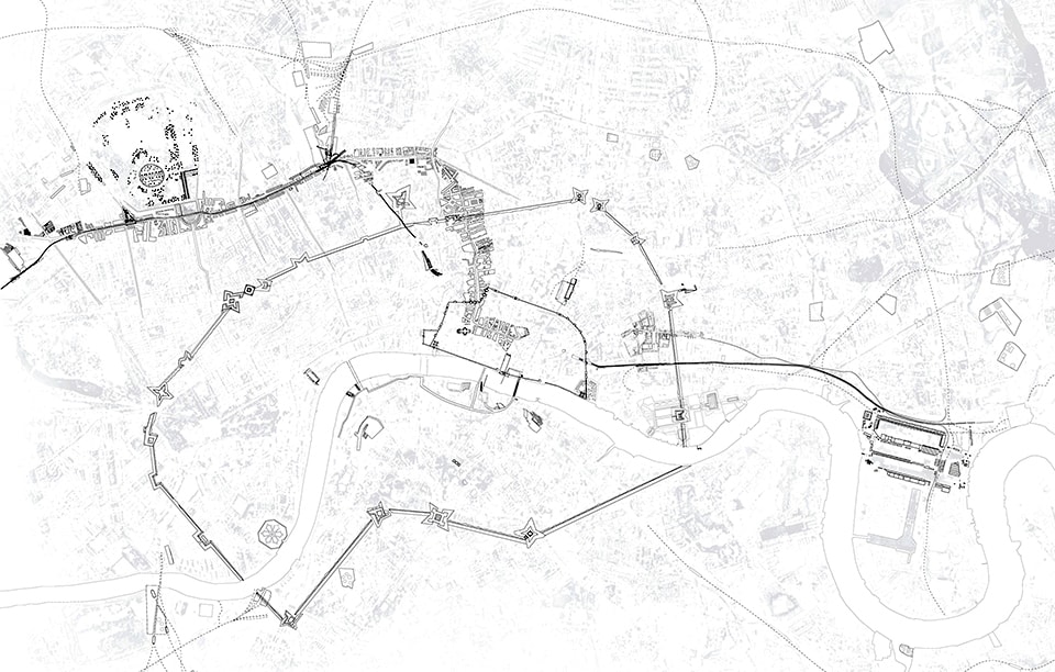
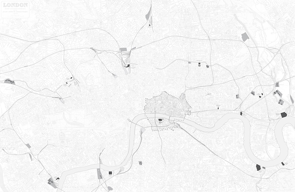
 Skeleton Forms: Map of infrastructure projects in nineteenth-century London overlaid on top of Fortifications of London City by Joshua Carrelo-Mendez [1]*

These parameters are not new in themselves: for example, Aldo Rossi’s work on the form of urban artifacts [4], Kevin Lynch’s identification of symbolic characteristics in describing neighborhoods [5], and the design of large urban “island” boundaries by O.M. Ungers in his 1977 Sommer Akademie [6] are all attempt to use architectural language to describe urban conditions. This paper, and the student work that was produced in design seminars on the same subject, aims to extend these three principles to infrastructure.

Architects work by synthesizing a disparate array of information in order to produce physical form. The method of dialogue between architect, clients, consultants, and end-users broadens the scope of questions and helps determine possible solutions. The ability to convert diverse qualitative information into formal responses — to think architecturally — is a fundamental strength of architectural methodology, independent of the scale and form that this response takes [7]. As the most direct way to address basic human needs within a city (running water, a reliable supply of electricity, adequate plumbing and other services), infrastructure is usually part of this process, mediating between these questions and their architectural “answers.” As Reyner Banham stated in his 1965 essay for Art in America “A Home is not a House,” infrastructure acts as the agent between social life and the architecture that accommodates it [8]. It is infrastructure’s agency and its ability to act directly on the city that has been the focus of design seminars I have recently been undertaking with students at The Cooper Union and Cornell University. Infrastructural case studies were momentarily treated as discrete, symbolic forms, which allowed us to see them as actors that respond to and change the city around them. Viewing the city as a collection of infrastructural projects that mediate natural resources in order to supply urban needs re-frames the concept of “the city” into a complex site of social, political and economic forces.


Boundary, Form and Symbolism

In contemporary culture architects are commonly viewed as producers of icons. In the case of the iconic building, boundary, form and symbolism are concepts central to architectural discourse and are easy to discuss. The boundary is typically the line where the façade meets the street, separating architectural form from its less significant context. Form can be discussed by comparing one building to other buildings of a similar type: for example, by relating Mies van der Rohe’s Seagram building in New York to that of Bunshaft’s Lever House across the street, both being early examples of modern, curtain-wall skyscrapers. Symbolism involves the way the building communicates ideas about itself via its overall form or in its details: the continuity of floor surface from the plaza outside to inside allows us to read the lobby of the Seagram as an extension of the city, rendering the tower above a suspended slab hovering above Park Avenue.

The architectural parameters of boundary, form and symbol have also been used to identify and classify architectural artifacts at a larger scale [9]. Palladio’s projects for the Piazza dei Signori in Vicenza provide an early example. Taken together, the Palazzo della Ragione (1549-1614) and Palazzo del Capitaniato (1565-71) transform the piazza into an architectural object by redirecting focus onto the public space created between the buildings. In this case, the form is that of an urban space and is achieved through a number of similarities at its edges: in the columnar rhythm of the many facades, the details of the arched openings and their ground floor arcades. The previously empty void of the piazza is transformed into the object of study, achieving the same significance as what the buildings, as architectural objects, would normally hold.  The boundary of this new, complex entity becomes re-drawn to include the architecture of the facades and arcades, as well as their context: the piazza itself. Henceforth the emphasis on architectural space over architectural objects becomes even more conspicuous in Renaissance urban restructuring.

Applying the parameters of boundary, form, and symbolism to the much larger scale of infrastructure is a greater challenge, but one that might allow us to understand more directly how agency is effected in the contemporary city. For example, the trajectory and form of street projects are shaped by the different political, social and economic factors guiding their implementation and thus reflect a particular urban culture. Streets are used as transportation and services infrastructure but they also give order to, and symbolize the culture of, a city. An exemplary model is Sixtus V’s street projects for Rome in 1585-90, involving a series of straight avenues that cut through medieval fabric to connect the monuments of the new Roma Christiana in anticipation of Jubilee visitors. This strategy becomes familiar in the nineteenth century: a street-turned-architectural space, lined with Baroque facades and enclosing monuments within its interior. However, a good comparison of how transport infrastructure gets implemented as architecture is between John Nash’s Regent Street in London (designed in 1811) and Baron Haussmann’s network of boulevards (begun in 1853). While both use a street to re-structure the city at a larger scale, cut visual corridors through a disorderly medieval town, control latent social unrest, and craft an expanded civic or imperial identity, the differences in their form are striking. The Parisian example is completely straight, benefitting from lenient eminent domain policies and weak private resistance to top-down planning. By comparison, the winding trajectory of Regent Street indicates something of the nature of private property rights in London, which did not allow for the kind of wholesale carving that Haussmann was able to achieve in Paris. Both employ neo-classical facades to fashion an identity for the street that symbolically represents the reigning power of their respective cities; however Nash’s reliance on private financial involvement meant that he had to accommodate multiple interests and different programs, which lends Regent Street a picturesque variety [10]. Haussmann’s adoption of neo-classical facades — already established by Percier and Fontaine in the design for the Rue de Rivoli in1802 and quickly associated with the Napoleonic Empire — is implemented without interruption throughout the network of boulevards in Paris, identical façades lining up one after another and articulating a continuous horizontal band that spans across buildings and unites them into a larger processional route.

 John Nash, Regent Street, 1811

 Baron Haussmann, Boulevard de Sébastopol, 1854

By applying architectural parameters to infrastructural projects, we gain insight into how specific projects act as players in a broader cultural environment. Rather than viewing — and designing — architecture and urban space as a layer that sits upon a neutral base of evenly-distributed infrastructural networks, we can assess how infrastructure is used as a vehicle for political, social and economic agendas. The design seminars at Cornell University and The Cooper Union did this by studying infrastructure projects architecturally: rather than approach infrastructure as solely a system (though it might behave as one) and a network (though it may be structured as such), the students were asked to look for the historical and formal particularities of their case study by defining a limited boundary of effects, analyzing their form, and discussing how the infrastructure adopted a symbolic role within the city.


Skeleton Forms: London

The research undertaken by the seminar class at Cornell utilizes this approach across scales by studying the relationship between the architectural object and the larger infrastructural influences of specific case studies in one city — London — in order to study their effect on the city’s growth. The project proposes that the infrastructural decisions of the city are determined by its political, social and cultural life, lying beneath the visible city like a skeleton structure. Instead of assessing the infrastructure of London as a network, something that assumes evenness in extension and application, this seminar’s approach asked students to analyze discrete case studies in order to create a composite image of the city through its individual, infrastructural, forms. The seminar asked: What determines the boundary of an infrastructural project? How does it overlap with other discrete projects and what part of the larger ‘network’ is adopted into the urban fragment?

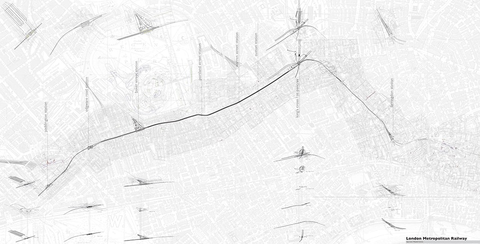
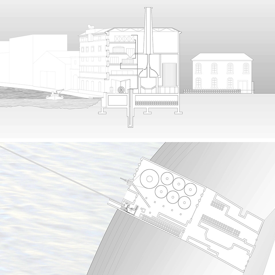
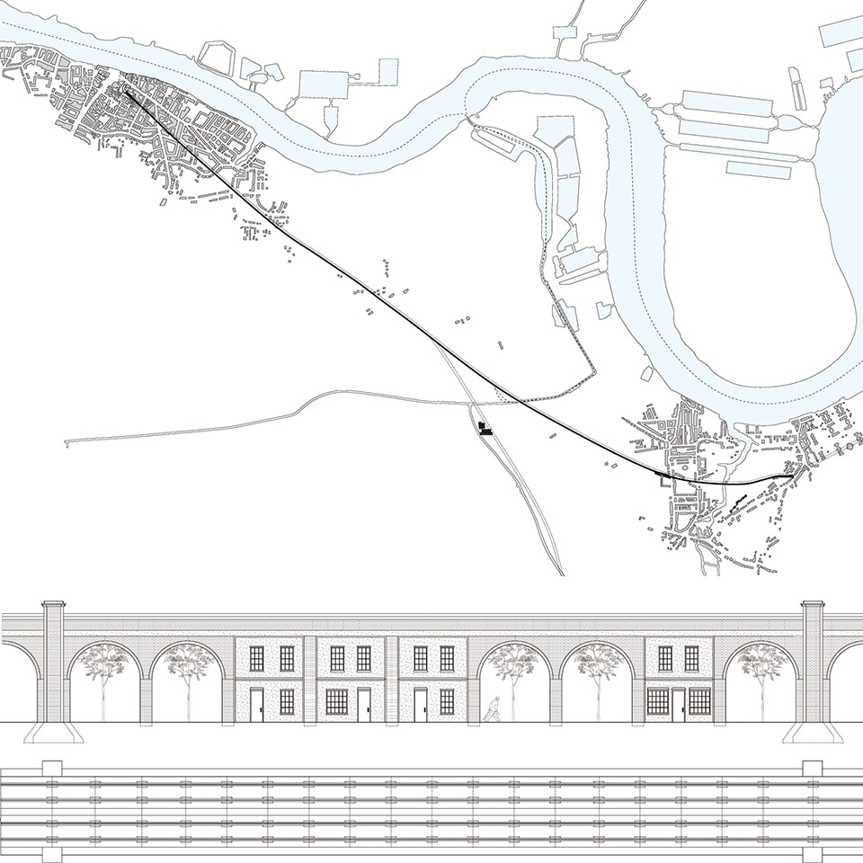
Part research, part drawing, and part analysis, the results of the seminar give a picture of nineteenth-century London shaped by public-private infrastructural ventures. This period is particularly interesting because it represents an early stage of infrastructural development when monumental architecture was used to symbolize technology’s role in modernizing cities. The case studies were combined to create a composite map of the city and allowed students to discuss relationships between projects over time. Many conclusions can be drawn from this collective body of research. For example, we see how early private power stations converting coal into electricity on the banks of the Thames were a linchpin between coal mines developing throughout the United Kingdom and the small area of the city that benefitted from early lighting. In doing so, they also influenced the location of train termini that were receiving significant coal traffic. Above all, it reminds us of the lasting impact made by the walls of London long after their removal: they are the limit of early electrical distribution by the Bankside Power Station in London, they serve as an ethereal guide by which the termini of railways are located — lines of trade that extend out into England to bring goods into and out of the city. We find that the penitentiaries sit on top of, or beyond, the ghost of this wall, typical of nineteenth-century spaces of exclusion [11]. It becomes clear that the London Metropolitan Railway of 1836 — the first underground line — invisibly tracks the first omnibus route along the New Road, an early turnpike constructed in 1756 to bring cattle to the markets by bypassing central London; that breweries, consuming coal, water and grain in huge quantities, had to be located near wharfs along the Thames both to import this resources, but also to ship spent grain to nearby cattle farms and their products all over the country; and that the increase in prisoners in the nineteenth century produced prison hulks recycled out of navy ships that fostered relationships with industry, such as the Royal Arsenal that was run by prison labor. Above all, it reminds us of the lasting impact made by the walls of London long after their removal: they are the limit of early electrical distribution by the Bankside Power Station in London, they serve as an ethereal guide by which the termini of railways are located — lines of trade that extend out into Endland to bring goods into and out of the city. We find that the penitentiaries sit on top if, or beyond, the ghost of this wall, typical of nineteenth-century spaces of exclusion [11]. All of these relationships combine to create a collage that shows how London’s early infrastructural projects mediate between a pre-modern urban world visibly tied to its natural resources and the smooth, even networks of a modern industrial capital.

Throughout the project, which had been primarily focused on the history of urban form, a constant theme was how best to represent infrastructure. To accurately describe the infrastructural object meant locating it between inputs of various scales (raw materials in far-off mines or fields, sites of connection for transport, neighborhoods needing to be connected with banking centers or prison ships throughout the UK and its colonies) and outputs at the urban scale (electricity, beer, water, playgrounds). A consistent scale and type of drawing was impossible as the traditional methods of representation that apply to buildings could not grapple with the range of environmental effects. Likewise, a graphic abstraction of network diagrams could not effectively show how projects had reacted to specific events on the ground: forms of landownership, neighborly rivalries and local resistance or promotion. This problem became a recurring discussion in the seminar and reflects another fact of architectural methodology: as architects, we draw much more than we build. In order to find an architectural approach to the infrastructure that is so visibly a part of contemporary life, it is also important to ask how we can draw it.

Studying and drawing these models of public-private cooperation in infrastructure is especially instructive today, with the era of large-scale, government-funded initiatives fading behind us. The case studies give particular insight into how a project develops by accommodating private motivation, an agency that can be both productive and destructive, and deserves to be recognized as part of current practice and scholarship. By studying infrastructure through the lens of form, boundary and symbolism, architects can fashion a response that is both relevant to contemporary cities and truly architectural in nature.

Loren Rapport, Bankside Power Station and the Coal Yards of London, 1890

Miran Jang, Holborn Viaduct (partial), 1863

Rodney Bell, the London Metropolitan Railway, 1863

David Bibliowicz, the Lion Brewery, 1836

Ben Hoffman, the London and Greenwich Railway, 1836

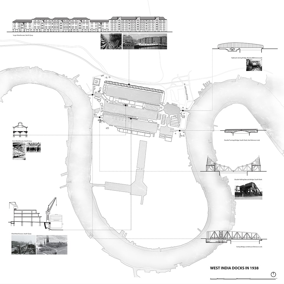
Zuhal Kol, the West India Docks, 1802 -1973

Christopher Ray, Prison Ships and the Royal Arsenal works, 1840


*Acknowledgements

Combined drawing of London, Skeleton Forms: Map of infrastructure projects in nineteenth-century London, was created by: Rodney Bell, David Bibliowicz, Joshua Carrelo-Mendez, Yuriy Chernets, Lily Chung, Nicholas DeMaio, Shuning Fan, Ben Hoffman, Miran Jang, Taleen Josefsson, Zuhal Kol, Tzara Peterson, Loren Rapport and Christopher Ray.


Laila Seewang is a practicing architect in New York City with built works in the United States and Australia. Her current research centers on theories of urban design, specifically the political and social effects of infrastructure throughout history. She has taught at Cornell University, The Cooper Union, GSAPP Columbia University, Princeton University, and Monash University in Melbourne, both in studios and in seminars on the history and theory of urban design. Previous experience in New York includes urban design at Pei Cobb Freed and Partners and architecture at Diane Lewis Architect, as well as prior experience in Australia. She has been published in Learning from Single Story Urbanism by Lars Muller, The New York Times and has exhibited at the Center for Architecture in New York.

Seewang received her B.Sc (environmental design) from the University of Tasmania, her B.Arch. from The Cooper Union, and her M.Arch. from Princeton University.


Refrences

[1] The fortifications of London City have played a major role in structuring urban development and, as such, provided a good reference by which other projects could be assessed.  From the Roman walls, the Riverside and Blackfriars extensions, trenches added for communication during the Civil War, and, following demolition, the Ring of Steel in 1993 attempted to quell IRA and post-9/11 attacks and finally the Ring of Congestion in 2003, London City has continually re-defined its boundaries, from the visible to the invisible, providing an obstacle and guide for later infrastructural projects

[2] See for example Stan Allen’s discussion of artificial ecologies and information landscapes in “Urbanisms in the Plural,” Practice: Architecture, Technique and Representation (New York: Routledge, 2009): 159-191 and Grahame Shane’s seminal introductory essay “The Emergence of ’Landscape Urbanism‘: Reflections onStalking Detroit,’” Harvard Design Magazine 19 (Fall 2003/Winter 2004): 1-8.

[3] Lars Lerup concisely articulates the transformation of the traditional city into a metropolis that replaces boundaries and form for flows and networks in “Stim and Dross,” Assemblage 25 (1994): 82-101. Stan Allen elucidates the significant role of infrastructure in urbanism in “Infrastructural Urbanism,” Points and Lines: Diagrams and Projects for the City (New York: Princeton Architectural Press, 1999): 46-57.

[4] Aldo Rossi, The Architecture of the City (Cambridge: MIT Press, 1984)

[5] Kevin Lynch, The Image of the City (Cambridge: MIT Press, 1960)

[6] Oswald Matthias Ungers, et. al., “Cities within the City: Proposal by the Sommer Akademie for Berlin,” Lotus International 19 (1977), 82-97.

[7] Nigel Bertram and Marika Neustupny discuss the role of the architect in facilitating problem-solving for a variety of ills in rural communities in Australia. Ranging from management, event planning, landscape, and infrastructure, “architectural” solutions were only minor. Nigel Bertram and Marika Neustupny, “Sparse Urban Environments: Design Strategies for Possible Features,” in The Changing Nature of Australia’s Country Towns, ed. Maureen F Rogers and David R Jones (Melbourne: VURRN Press, 2006).

[8] Reyner Banham and François Dallegret, “A Home is not a House,” Art in America 2 (1965),70-79.

[9] See for example Aldo Rossi’s discussion of urban artifacts in The Architecture of the City, Kevin Lynch’s definition of “neighborhood” in The Image of the City, and the proposals for how to determine “island” boundaries based on urban character in Oswald Matthias Ungers et. al., “Cities within the city: Proposal by the Sommer Akademie for Berlin”, in Lotus 19.

[10] John Summerson, “The Plans and Elevations of John Nash,” in Georgian London (London: Pleiades Books, 1947), 160-173.

[11] See Michel Foucault and Jay Miskowiec’s description of heterotopic institutions such as prisons, cemeteries and hospitals and their removal to sites outside of the city, in “Of Other Spaces” Diactritics 16:1 (1986), 22-17.

Queens Plaza: A New Core For Long Island City

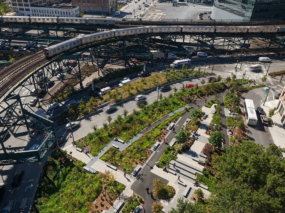
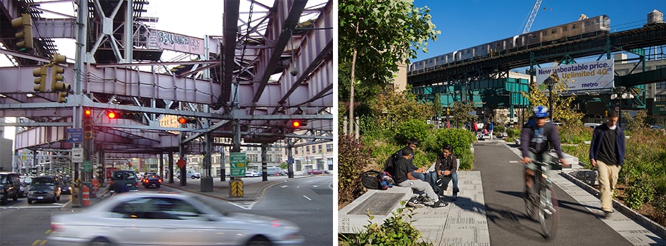
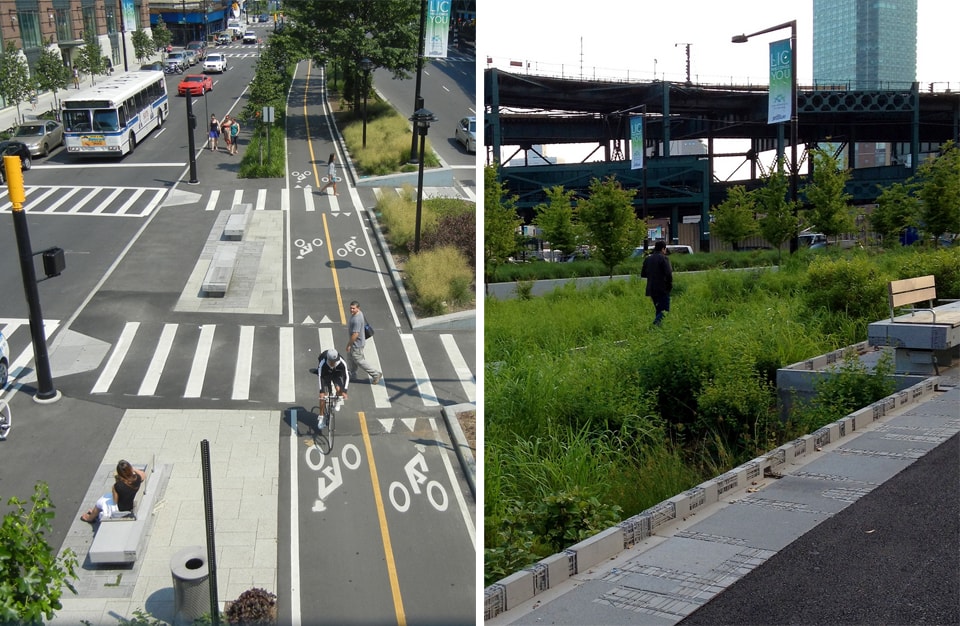
In 2003, New York City’s Department of City Planning initiated a project to transform what was a tangled and hostile landscape of streets, elevated trains, bridges, aborted bikeways and traffic medians at Queens Plaza, the gateway to Long Island City.  Over the next eight years, the broad confluence of streets and residual spaces was transformed into a hybrid landscape:  not just infrastructure, not just street, not just park or refuge, not just conduit.  The design wove these threads into a civic space that is of the street, of the neighborhood, of the elements, of the culture.  It has transformed life for residents of Long Island City and beyond, who can now commute by bicycle with ease into Manhattan, and who have eagerly claimed the 5-acre green open space as a place to gather, to rest, and to recharge.

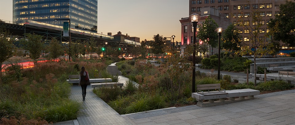
Photo by Sam Oberter

Queens Plaza was one of the two pilot projects for New York City’s High Performance Infrastructure Guidelines. The overall design is a pioneering urban landscape design that fulfills the City’s High Performance Infrastructure Guideline’s author’s call for landscapes that “store and clean water, filter air, help improve public health, and provide habitat and biotic connectivity to increase biodiversity, in essence to become organic infrastructure” [1]. The RFP was the first we encountered that called for sustainable design to be placed front and center.  At the same time, our definition of sustainable design had begun to grow more complex than the traditional intersection of social, economic and environmental concerns.  During the course of this project we came to see sustainable design as the intersection of art, ecology and infrastructure that drove our urban landscape design work and measured its success.

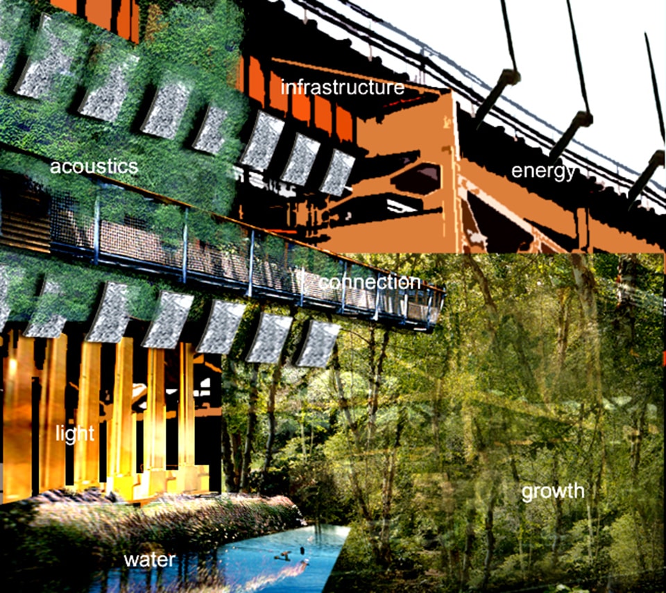
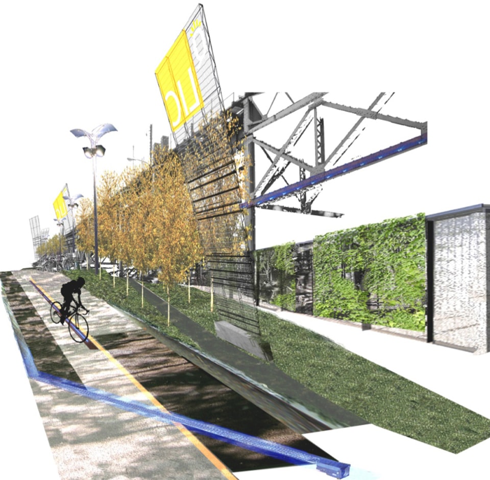
This early ideagram shows how we would transform the infrastructure into a place where energy, light, water, and plantings would reinvent connections through the site. Image by Margie Ruddick Landscape

Throughout the plaza, diverse strips of planting along the medians absorb storm water, temper the harsh environment, and improve air quality.  A broad swath of ironwood trees arcs along the elevated structure at JFK Park, enfolding and sheltering the refuge-like park landscape.  A river of understory trees – shad, redbud, magnolia – meander within the park, then along the medians, down to the river.  This immersive green landscape radically challenges the conventional notion of an urban park/streetscape as hardscape. Our team fully integrated environmental artist Michael Singer into the design process, so that we did not just identify opportunities for art within the landscape, but we considered every aspect of the project as a medium for art.  Singer worked with the team to design sculpted curbs that conduct storm water into the subsurface wetland, and down to recharge groundwater. Our intention was to render visible the forces of water, wind and sun as they moved through the landscape.  Phase 2 of the project, still to be constructed, reveals the elevated structures and bridge through a series of mesh and light “rooms,” which clarify the rhythms of the structure, transforming it from a tangle of steel into an elegant, lantern-like serial installation. After less than a year since opening, Queens Plaza is teeming with people walking, jogging, biking, strolling, lunching, meeting and reading.  The project’s success is as much because of its porous boundaries – you are directed into and through it via five or six different pathways, and then out into the City again.  At Queens Plaza, a former traffic island/parking lot is now a refuge, and the infrastructure that was once reviled is now fully engaged in the streets of the city, and is once again beautiful.

Initial site conditions at Queens Plaza [left]; The one-mile tangle of infrastructure that runs from Sunnyside Yards to the East River turned into a lush green corridor welcoming to pedestrians and bicyclists. Photo by Sam Oberter [right]

Integrating water, movement, plantings, energy, shade, and signage (Image by Margie Ruddick Landscape)

The system of berms, planting, expressed steel curbs, and pedestrian and bicycle paths stretches out at JFK park to become an embracing landscape [left]; Small outlets in the sculpted curb allow the water to flow from the path down into the wetland. Michael Singer Studio fabricated all of the artist-designed curbs, pavers and benches at his studio [right]. Photos by Marpillero Pollak Architects

Photo by Sam Oberter

Project Team

Margie Ruddick  – Design Lead Marpillero Pollak Architects – Architecture and Urban Design Michael Singer Studio – Public Art WRT – Landscape Architecture Leni Schwendinger Light Projects – Lighting Design Langan Engineering – Civil Engineering


Margie Ruddick is an international, award-winning landscape designer. For over twenty-five years, she has been recognized for her pioneering, environmental approach to urban landscape design, forging a design language that integrates ecology, urban planning and culture. Margie is the recipient of the Smithsonian’s Cooper-Hewitt 2013 National Design Award, a nationwide awards program honoring excellence, innovation, and lasting achievement in American design. Margie’s international projects include the Shillim Institute and Retreat in the Western Ghats of Maharashtra, India. Margie also traveled to Chengdu, Sichuan, China to work with artist Betsy Damin designing the Living Water Park, the first ecological park in China, which cleans polluted river water biologically. Margie’s forthcoming book is entitled Wild By Design.  For more information please visit www.margieruddick.com.


Refrences

[1] Hillary Brown, Steven Caputo Jr., Kerry Carnahan and Signe Nielsen, High Performance Infrastructure Guidelines (New York: Design Trust For Public Space, 2005) Available in full at http://www.designtrust.org/publications/publication_03hpig.html  

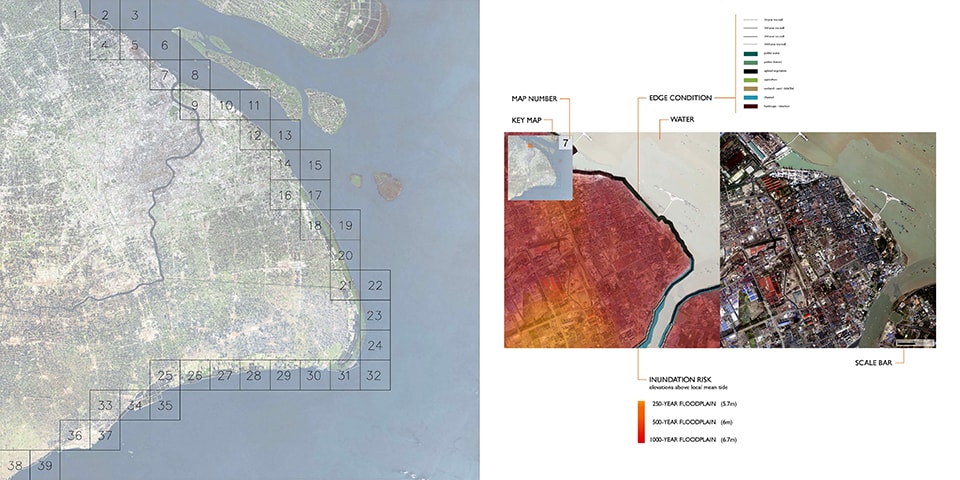
Yangtze River Delta Project

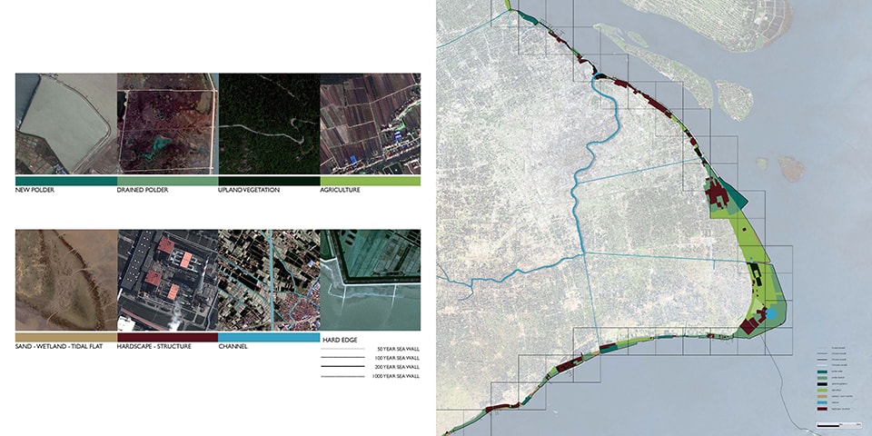
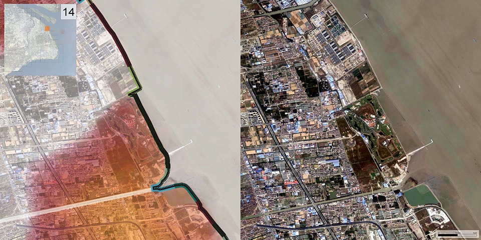
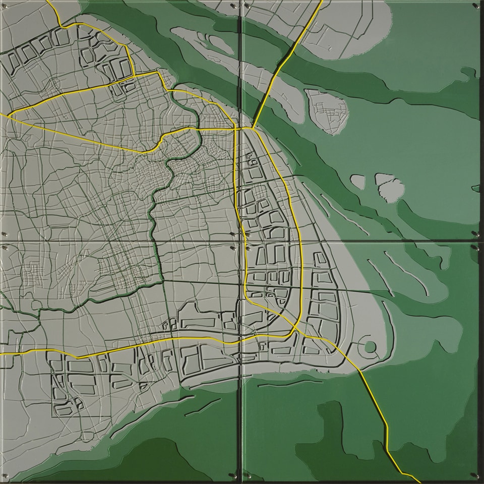
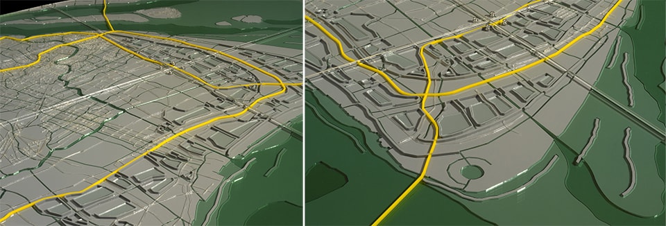
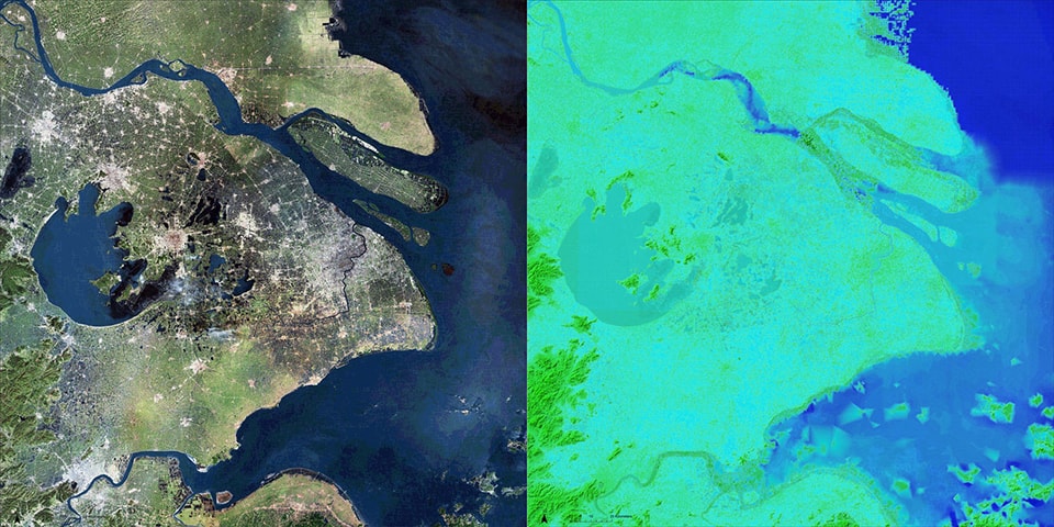
The Yangtze River Delta Project (YRDP), exhibited at the Princeton-Fung Global Forum “The Future of the City” in Shanghai, January 2013, is a low-tech but large-scale climate adaptation and flood management proposal for the Yangtze River Delta. Led by City College of New York landscape architect Catherine Seavitt and Princeton University structural engineer Guy Nordenson, with coastal engineer Ning Lin, chemical engineer Howard Stone, and civil engineer Michael W. Tantala, the YRDP research group developed a strategy of coastal climate adaptation and flood management for Shanghai, China. The research group’s methodology of analysis and design, which develops soft infrastructural strategies responding to sea level rise and storm surge and their effects on unique local conditions, has been applied to a series of studies addressing the adaptation of coastal cities in a changing climate. Other studies undertaken by the research group include projects for the transformation of New York and New Jersey’s Upper Harbor and a land-building sediment diversion proposal for the Mississippi River Delta. 

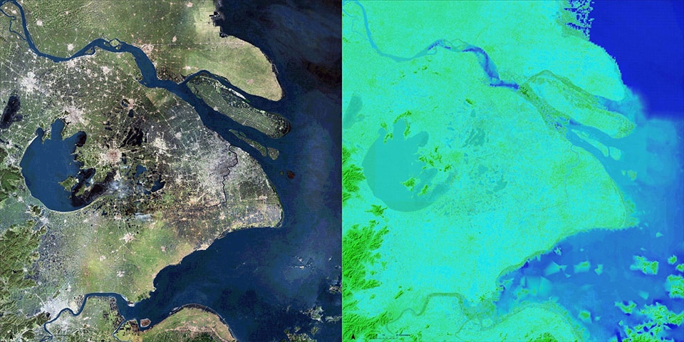
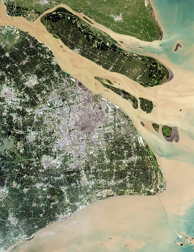
Satellite image of the Yangtze River Delta. [left];
Merged bathymetric / topographic model of the Yangtze River Delta. [right]
Images © Yangtze River Delta Project, 2013

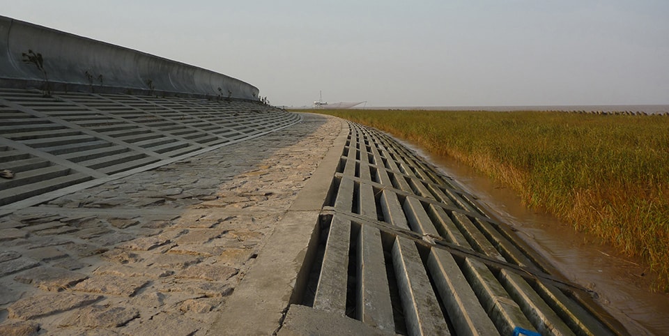
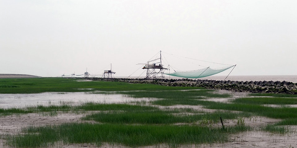
As sea levels rise and oceans warm, coastal cities around the world must reconsider their resilience to the increased frequency and intensity of climate events such as storm surge, heavy precipitation, and high winds. In New York City, the destructive landfall force of both Hurricane Sandy and Hurricane Irene has provoked a debate among scientists, engineers, policy makers, architects, and landscape architects about how to resiliently adapt dense urban settlements to the force of powerful storms and the continuing risk of rising seas. Coastal infrastructure must be reconsidered; this is an ongoing debate in many global cities such as Rotterdam, London, St. Petersburg, and New York. Yet each city has its own geomorphic properties, and each culture has its own civic attitude concerning risk and risk management. In Shanghai, the largest city in the People’s Republic of China, twenty-three million people live at an average of just thirteen feet above sea level, within a historically shifting deltaic landscape of alluvial flows. The Yangtze River Delta Project seeks to reimagine the extensive rigid seawall infrastructure that is nearing completion at the East China Sea. Instead of accepting the contemporary attitude of attempting to exclude water completely, the YRDP embraces the wisdom found in ancient Chinese techniques for floodwater management within a deltaic landscape, finding inspiration in these historic treatises that suggest keeping berms along the canals low, dredging minimally, and designating floodplain zones to accept floodwaters.

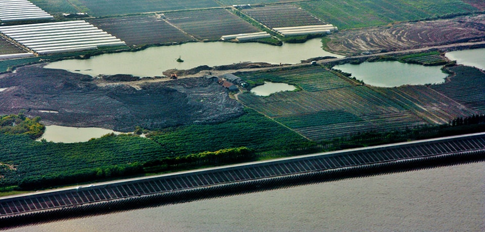
Yangtze River Delta oblique aerial view, showing the varied land use and the seawall at the East China Sea, 2008. Photo by Marc Latrémouille


The Long River and the Delta Plain

The Yangtze River, known as the Chang Jiang (“Long River”) in Chinese, is the third longest river in the world, with a length of over 3900 miles and an elevational change of over 20,000 feet. Its watershed drains twenty percent of China’s total land area, over 700,000 square miles. Thirty percent of China’s population lives within this watershed, and the river is the country’s commercial spine. The Yangtze also carries a huge amount of sediment—each year, over 600 million tons of mud and silt are discharged at the mouth of this tidally-dominated delta to the East China Sea, muddying the waters for seventy-five miles beyond its conflux with the sea.

Sediment load at the Yangtze River Delta. Image by NASA

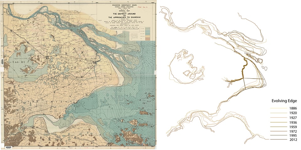
This huge volume of Yangtze River sediment also creates land. Until the seventh or eighth century CE, much of today’s Shanghai was wetland marsh. Geologically part of a slow-growing strand plain, the Yangtze Delta was formed by a series of chenier shell ridges that gradually extended the deltaic plain seaward through the sedimentary deposition of the Yangtze River. It is estimated that delta plain advances toward the sea one mile every seventy years (approximately two kilometers per century) [1]. This occurs through a slow process of ridge sedimentation, or chenier ridge growth, in which earthen ridges with embedded shells develop naturally at the delta plain through the deposition of riverine sediment countered by wave action. These ridges are overtopped by landward moving waves, and vegetation gradually begins to stabilize the ridge. The chenier plain is characterized by this sequence of parallel earthen ridges slowly accreting seaward. This sedimentary growth is clearly revealed through a study of historic maps of the delta, including the detailed British map of territories, topographies, and soundings produced in 1920 by the Whangpoo Conservancy Board.

General Map showing the District Around and the Approaches to Shanghai. Image by Whangpoo Conservancy Board, 1920. Earth Sciences and Map Library, University of California, Berkeley [left];
Coastal sedimentary accretion at the Yangtze River Delta [right]
Image © Yangtze River Delta Project, 2013

Historically, the parallel chenier ridges of the delta’s terrain were the natural areas of high ground in an otherwise flat landscape, and traces of settlement by humans, as well as the construction of irrigation canals and terraces for rice production and dikes for channeling floodwaters, have been dated to the Neolithic period. Given the fertile alluvial soil, the hot and wet summer climate, and the availability of water due to the shallow water table, agricultural land use is intensive at the Yangtze Delta. The lower Yangtze region has long been considered the grain basket of China, but now the region’s productivity is being threatened by saltwater intrusion as sea levels rise, and the alluvial soil is subsiding because of the pumping and extraction of groundwater to support intensive development.


Infrastructure and Risk

The low-lying Yangtze River Delta is also home to an enormous array of commercial and transportation infrastructure. The most developed area in China, the Delta includes the important industrial centers of Nanjing, Wuxi, Suzhou, and China’s largest city, Shanghai. The densely populated urban core of Shanghai, situated along the Huangpu River, has twenty-three million inhabitants. The Port of Shanghai is now the world’s busiest container port. Begun as a treaty port in 1842, it has three working zones: a deep water port in Hangzhou Bay, an estuary port at the mouth of the Yangtze, and the historic river port along the Huangpu River in central Shanghai. The Shanghai Pudong International Airport is an important transportation hub for both cargo and passengers and represents another significant and ongoing infrastructural investment at the coast. The airport, opened in 1999 and expanded in 2008, is currently undergoing a second expansion, which will double the airport’s capacity by 2015.

Despite such investment in critical transportation and commercial infrastructure, the Yangtze Delta region is barely above sea level. Shanghai sits at an average of thirteen feet above the mean tide and is thus particularly vulnerable as the climate warms and sea levels rise. In June 2012, a study of nine international coastal cities built on river deltas determined that Shanghai was the city most vulnerable to flooding when considering physical, social, and economic attributes [2]. There are multiple geomorphic reasons: its geological foundations consist merely of alluvial mud deposited by the Yangtze River over hundreds of thousands of years. It is a lacelike tapestry of water and land, with thousands of linear canals for local irrigation and transportation snaking through the delta territory. In addition to its low elevation, it belongs to a region that has historic, current, and future vulnerability to tropical cyclones, or typhoons [3]. High winds, heavy rains, and storm surges from typhoons often occur along the coast of China during summer and autumn, and serious coastal flooding of the Yangtze River Delta has occurred in 1962, 1963, 1964, 1990, and 1997 [4].

Super Typhoon Winnie, 12 August 1997, satellite image. Image by U.S. Navy [left];
Random selection of the historical tropical cyclone tracks at coastal China, 1945-2007. Image by Yonekura and Hall, 2011 [right]

Hard-engineered dikes and seawalls have been built to counter the danger of flooding, but existing infrastructures may become less effective as sea levels rise and climate patterns shift. The Shanghai Bund, along the Huangpu River, has levees now maintained at a height of 6.9 meters, designed for a one-in-1000 year flood risk [5]. A floodgate at the conflux of Suzhou Creek and the Huangpu River, raised and lowered twice daily with the tides and weather, is also designed to withstand a one-in-1000 year tidal surge and to protect the Suzhou district of Shanghai. On August 18, 1997, Typhoon Winnie, designated as a Category 5 “Super Typhoon” when it attained peak winds of 160 miles per hour over the Pacific, brought the highest recorded surge event to the Yangtze Delta region, 5.72 meters (approximately 19 feet), when it made landfall just south of Shanghai. The Huangpu River broke through a dike and inundated over 400 homes with 1.5 meters of water [6]. Winnie’s floodwaters came within 14 centimeters of overtopping the 5.86 meter-high Suzhou Creek floodgate.

The Suzhou Creek floodgate, located at its conflux with the Huangpu River, 2013. Photo by Dorothy Tang

Formerly considered adequate protection, reliance on such infrastructures will become a riskier proposition as the probability of storms increases: changing weather patterns have been observed in several recent studies of this region, suggesting increasingly intense tropical storms due to westward shifts in storm tracks and increasing typhoon influence over the past half-century [7].

Seawall at the East China Sea in Pudong, Shanghai, 2010. Photo by Bo Shui

Recent construction of a new continuous seawall at the East China Sea, much of it built since 2009, is an acknowledgement of the billions of dollars invested in the transportation and industrial infrastructures behind it. Indeed, the region is dependent upon the singular and expensive flood control mechanism of the engineered seawall, despite its potential for catastrophic failure at any point along its length. Principles of resilient design would argue instead for multiple redundant defenses, and look to incorporate systems that can adapt to changing climate conditions rather than becoming ever more stressed and fragile. The Yangtze River Delta Project was initiated as a proposal to move beyond the singular hard-infrastructural strategy of the seawall, by designing additional layers of resilient protection thorough the use of redundant soft-infrastructural systems.

Spontaneous coastal marsh with fishermen’s nets just beyond the seawall, 2012. Photo by Sean Burkholder


Assessing Flood Risk

In order to accurately model the existing flood risk and assess the effects of proposed techniques that would increase resilience to flooding, the Yangtze River Delta Project began by developing a continuous topographic / bathymetric digital model of the region. This continuous numerical model, merging both land and ocean data, is an important tool; traditional oceanic models, based on depth soundings, end at the assumed “line” of the coastal edge, resulting in an artificial binary division between water and land. The continuous numerical model considers the terrain, both above and below the surface of the water, as a continuous topologic surface, a vessel containing the dynamic medium of water.

Bathymetric digital model of the Yangtze River Delta [left];
Topographic digital model of the Yangtze River Delta [right]
Images © Yangtze River Delta Project, 2013

For the continuous numerical model, two GIS datasets—a topographic digital model and a bathymetric digital model—were merged to create a seamless depiction of the terrain both above and below the water. When seen in a satellite image, the “coastline” of the Yangtze Delta appears as a distinct line dividing water and land; the merged topographic / bathymetric model, by contrast, reveals the continuity of this terrain, showing the continuous gradient of the terrain’s surface and challenging the singularity of the divisive line at the coastal edge.

Satellite image of the Yangtze River Delta [left];
Merged bathymetric / topographic model of the Yangtze River Delta [right]
Images © Yangtze River Delta Project, 2013

This merged topographic / bathymetric model provided the surface onto which the statistical models of typhoon storm surge events could be mapped. Using surge heights for 250-year, 500-year, and 1000-year statistical storm models, the merged model reveals that many of the municipal districts around central Shanghai are low-lying areas at high risk of inundation. The Shanghai Edge Atlas, detailing seawall conditions and land use along the coast, was developed to establish coastal elevations on the continuous digital model.

Inundation risk maps of the Yangtze River Delta, showing 250-year, 500-year, and 1000-year flood plains. Images © Yangtze River Delta Project, 2013


Shanghai Edge Atlas, selected pages, including edge typologies, key maps, satellite imagery, and inundation risk. Images © Yangtze River Delta Project, 2013


The Open Polder

In the search for a design strategy for the Yangtze Delta proposal, one that would respond to both the risk of storm surge and provide new techniques for managing floodwaters, the research group was intrigued by the philosophy of Yu the Great (2200-2100 BCE, founder of the Xia Dynasty), who devised a protective response to the historically devastating floods in China through a moderate, soft infrastructural approach. Rather than building dams and high dikes to impede the flow of water, Yu created a system of irrigation canals that relieved riverine floodwaters into agricultural fields, building low earthen dikes to guide the water’s flow. Yu’s techniques allowed for the movement of water rather than its static impoundment through damming; these worked with the simple dynamics of a gravity-fed hydrological system to relieve pressure and reduce flooding [8].

The Yangtze River and its extensive flood plain has long been the site of an agricultural society in China which is dependent upon flooding. Low-tech techniques were developed to control the movement of floodwaters, and the strategic use of canal dredging and bunding for the capture of water for irrigation have been harnessed for rice paddy production for thousands of years. Bunding, the process of gathering of soil into low ridges to form the edges of stepped terraces, echoes at a smaller scale the sectional characteristics of the naturally formed chenier ridge. Floodwaters are engaged to irrigate the rice fields, and simple gravity flow within each field allows the irrigation water to descend thorough a series of carefully managed terraces. Canal building through trenching and berming was also employed as part of urban and rural planning technique in recent Chinese political history, a labor-intensive process involving the displacement of earth through the techniques of cut and fill and employing the use of the wheelbarrow [9].

China, Reisfelder bei Peking

Chinese rice fields near Beijing, 1920.
 Image by Deutsches Bundesarchiv, #137-004023

The YRDP team examined Yu’s concept of the agricultural field as a flood overflow zone though the conceptual development of a “passive” polder. A polder is essentially an earthen embankment or dike enclosing a low-lying area of land. The Dutch are perhaps best known for their techniques of land reclamation and flood defense through the construction of polders, but the Chinese have also extensively employed poldering as a strategy for protecting agricultural lands within riverine floodplains, particularly along the middle Yangtze River. But the fully enclosed polder demands maintenance and often requires the expenditure of energy through mechanized pumping. An enclosed polder creates an artificial and self-contained hydrological zone; the polder’s only connection to water outside of its contained area is through a sluice or gate system. In the Netherlands, coastal marshes or bays were separated from the surrounding water by dikes, drained with pumps, and planted with reeds to speed drying via transpiration. The resulting dry land generally subsides, creating an area that is thus below the surrounding water level. During rain or storm events, a polder system must be mechanically drained of excess water by pumps to prevent flooding.

The “passive” or “open” polder proposed by the YRDP is conceptually more resilient than the fully enclosed polder; it does not fully encircle a territory and thus maintains a semi-enclosed area as part of the surrounding hydrologic watershed, avoiding issues of continuing subsidence. The open polder functions as a kind of temporary reservoir, designed to hold floodwaters and slowly release them via gravity. Rather than attempting to exclude floodwaters, the open polder system intentionally accepts overflow and provides a slow release of water.

In the Yangtze River Delta Project, low figural earthen dikes form these open polders by wrapping agricultural territories adjacent to major linear canals. Several simple physical models were constructed and tested with water to analyze hydrodynamic flow, given variables such as canal depth, angle of canal intersections, and low berm/polder perimeters with gravity outlets flowing toward canals. Conceptually, the open polder allows for the collection as well as the controlled release and outflow of flood waters. This strategy applies the principles of “controlled flooding”—collect, retain and release—rather than the traditional formula of “flood control,” which attempts to exclude all water.

Open polder water tank study model, clay. Images © Yangtze River Delta Project, 2013


Constructed Berms

The Yangtze River Delta Project design focuses on the Shanghai Municipality’s coastal delta districts of Pudong, Fengxian, and Jinshan, wrapping from north to south along the coast, along with the area just west of the mouth of the Huangpu River. To increase the resiliency of the Delta region, the Project deploys a low-tech but large-scale intervention of earthen berms, which serve to reduce damage from storm surge by attenuating wave energy, slowing wave velocity, and temporarily capturing floodwaters, allowing the waters to be absorbed and to recede slowly.

Constructed linear chenier berm ridges, arrayed both on- and off-shore, help to slow surge velocity and dampen wave impact. Highways are raised atop similar linear berms, which act as both surge buffers and elevated evacuation routes. Figural earthen berms, the open polders, wrap agricultural fields, creating two overlapping curved bands across the four coastal districts. Simple cut-and-fill techniques, here interpreted as canal and berm, are used together with the traditional Chinese agricultural irrigation techniques of rice paddy bunding and terracing. The proposed semi-enclosed polders, arrayed in two broad bands, serve to capture water that overtops the coastal seawall and the three major canals connecting the Huangpu River to the East China Sea. Rather than mechanically pumping out water as in the traditional Dutch polder method, waters are absorbed and released via gravity flow through the existing and enhanced canal network.

Yangtze River Delta Project site model.
Image © Yangtze River Delta Project, 2013. Photo by Jock Pottle

The “open polders” and chenier ridges are conceived as a decentralized, redundant, and locally managed system that is embedded in both the geological history and the agricultural landscape of the delta, and are intended to decrease the vulnerability of Shanghai to the risks of sea level rise and increased typhoon activity. The flood waters of storm surge from typhoons are slowed, captured, retained, re-absorbed, and allowed to retreat in a systematically controlled manner.

Yangtze River Delta Project site model, detail of highways (in yellow) and open polders.
Images © Yangtze River Delta Project, 2013. Photos by Jock Pottle


Adaptive Landscapes

The Yangtze River Delta Project, as a collaborative examination of flood risk in the rapidly-developing landscape of metropolitan Shanghai, attempts to broaden the role of infrastructural thinking at the estuarine scale. Land use and urban growth must address the natural systems of earth and atmospheric sciences as well as the economic potential of real estate and capital. Nature is part of the urban realm.

Coastal urban estuaries, whether the Hudson River estuary, the Mississippi River Delta, or the Yangtze River Delta, are dynamic sites. These sedimentary terrains, affected by atmospheric and hydrologic systems as well as shifts provoked by climate change, must be reconsidered at the infrastructural scale in ways that acknowledge both urban settlement, agrarian use, and natural forces. Our deployment of a strategic process of design conceptually reframes the estuarine configuration to create a more resilient and adaptive landscape, a system that dynamically responds to the risks of sea level rise and the increased vulnerability of the coastal environment.

The consideration of land as a continuous topological surface extending above and below the water is a fundamental premise of our research and design proposals. This land surface, wet or dry, may be reconfigured to attenuate the wave energy of moving waters and capture, retain, and release floodwaters. In our work on the Upper Bay of New York and New Jersey, this is achieved through a field of archipelago islands and by the delineation of protective zones through the use of linear reefs. Land can also serve to channel water, transforming its speed and velocity and allowing for the dynamic movement and deposition of sediment for land building, as we examined in our proposal for additional diversions within the Mississippi River Delta. Or, land may be reconfigured through a simple cut-and-fill process to create a chenier-like field of linear berms and figural polders to retain and reabsorb floodwaters, as is proposed in our Yangtze River Delta Project.

The adaptive landscape operates systemically in varied atmospheric, tidal, and storm conditions. We employ “soft” infrastructural techniques, which we define as multiple and iterative strategies that buffer, absorb, or temporarily retain flooding. Our design proposals for adaptive landscapes strive to enhance the quality of urban life and the resilient health of the estuarine environment, while protecting against the risk of flooding and acknowledging the dynamics of sea level rise.


Credits

YRDP Research Group: Catherine Seavitt, Guy Nordenson, Howard Stone, Ning Lin, and Michael W. Tantala

YRDP Project Coordinators: Kjirsten Alexander and Rebecca Veit

YRDP Princeton University Student Researchers: Carly De La Hoz, Adam Fisch, Jessica Luo, and Anthony Salerno


CatherineSeavittCatherine Seavitt is an Associate Professor of Landscape Architecture at the City College of New York and principal of Catherine Seavitt Studio, an interdisciplinary practice integrating landscape and public infrastructure. Her research focuses on design adaptation to sea level rise in urban coastal environments, as well as rethinking landscape restoration practices given the dynamics of climate change. Seavitt is the co-author, with Guy Nordenson and Adam Yarinsky, of the book On the Water: Palisade Bay (Hatje Cantz, 2010), an infrastructural and ecological study and planning proposal for New York Harbor given the effects of sea level rise. This work served as the inspiration for the workshop and exhibition, Rising Currents: Projects for New York’s Waterfront, held at the Museum of Modern Art, New York, in 2010. She is currently investigating the history, processes, and ethics of the de-domestication of large herbivores for grassland restoration and land management.


References

[1] Lyman P. Van Slyke, Yangtze: Nature, History, and the River, (New York: Addison-Wesley Publishing Co., 1988), 23.
[2] Stefania Balica et al, “A flood vulnerability index for coastal cities and its use in assessing climate change impacts,” in Natural Hazards 64 (2012): 73-105.
[3] Emmi Yonekura and Timothy M. Hall, “A Statistical Model of Tropical Cyclone Tracks in the Western North Pacific with ENSO-Dependent Cyclogenesis,” Journal of Applied Meteorology and Climatology 50 (2011). Note that both typhoon and hurricane are regionally-specific names for tropical cyclones.
[4] Tong Jiang, Analysis of Flood Hazards in the Yangtze River Valley and Strategies for Sustainable Flood Risk Management, (Aachen, Germany: Shaker Verlag, 2000), 17.
[5] Elaine Kurtenbach, “Rising Seas Threaten Shanghai, other major cities,” U.S. News and World Report, October 18, 2009, http://www.usnews.com/science/articles/2009/10/18/rising-seas-threaten-shanghai-other-major-cities.
[6] Associated Press, “Typhoon Winnie Slams China as Taiwan Cleans Up,” Sun Journal, August 21,1997, 17C, retrieved http://news.google.com/newspapers?id=zlIpAAAAIBAJ&sjid=MmsFAAAAIBAJ&dq=typhoon%20winnie%20taiwan&pg=3470%2C3148285.
[7] Congbin Fu et al., eds., Regional Climate Studies of China, (Berlin: Springer-Verlag, 2008).
[8] See Records of the Grand Historian: Han Dynasty and Qin Dynasty, translated by Burton Watson, (New York: Columbia University Press, 1993).
[9] Kris De Decker, “How to downsize a transport network: the Chinese wheelbarrow,” Low-Tech Magazine, accessed December 29, 2011, http://www.lowtechmagazine.com/2011/12/the-chinese-wheelbarrow.html.


Productive Filtration: Living System Infrastructure In Calcutta

Resilient, adaptive infrastructure cannot be built. It grows slowly but extensively, building up relationships in steps and bounds, integrating into surrounding systems, flows and entities; it evolves and shifts till it is essential and invisible.  With urban populations growing worldwide, particularly in the developing world, there is an increased interest in green infrastructure and productive landscapes capable of operating at an urban scale, potentially growing in scale and capacity in step with the populations they aim to support.  While the emotional lure of turning wholesale to “natural systems” to meet our infrastructural needs is incredibly appealing, and the ease of placing landscape features in renderings and design imagery, there are significant challenges involved in employing green infrastructure at a scale that meets present and future needs.  This paper presents the case study of a remarkable example of living systems infrastructure, the East Calcutta Wetland, a high-performance, engineered and managed ecological system that has developed over a century to treat urban waste, produce saleable fish and vegetables, create employment and support a local population and economy.

The value and complexity of the wetland cannot be captured by photographs or simple narrative prose. In order to learn from this example, as designers, engineers or policy-makers, it may be necessary adopt a new lens for approaching infrastructural systems that allows designers to move beyond mere outward appearance and form of infrastructural objects, to approach complex systems through an understanding of their essential behavior and the relationships upon which performance is achieved.

calcutta wetlands1

Figure 1 East Calcutta Wetland, an example of living systems infrastructure tightly bound to urban fabric and performance. Image from Google Earth

Living Systems Infrastructure and Urban Ecology

Living systems infrastructure utilizes landscape systems to perform ecosystem services (treating stormwater, increasing air quality, treating or processing waste, sequestering carbon, producing energy and nutrients), taking advantage of synergistic relationships between system components and functions [1]. In the urban environment, the performance requirements and constraints placed on infrastructure can rarely be met with truly natural, or unmediated systems. Living systems infrastructure presents a model of thinking and designing hybrid, high performance systems which use an ecosystem ecology perspective to construct and manage environments.

In order for living systems infrastructure to be a viable alternative or supplement to traditional modes of fixed, “grey” infrastructure, there must be a clear, and robust method for assessing the performance of these systems. As much as we may wish it otherwise, the challenge of measurement may very well be the largest impediment to utilizing living systems or green infrastructure at a meaningful scale. It will likely always be easier to predict the future performance of a mechanical system than a biological system. It is easier to accurately predict the flow rate of a culvert than a river; it is easier to assure the sewage treatment capacity of an activated sludge plant than a constructed wetland. Our ability to understand these systems, our ability to describe them and draw them, is crucial to our ability to see them as meaningful strategies and within the realm of design possibilities.

Bringing environmental engineering and environmental management to urban landscapes in a large scale and distributed manner is not just a question of assuring design quality and performance, it also causes us to reconsider the idea of the city, the functioning of its essential building blocks and the relationships of urban components – be they constructed or natural, social, economic or environmental.


Urban Ecology; Unpacking the City

Living systems infrastructures are not merely “soft” or “resilient” machines as popularly hypothesized in architectural circles [2,3,4]. Rather, they are better described as engineered ecosystems. Ecosystems ecology is a useful method for studying the urban environment and for managing resources as it calls attention to the relationships which link biotic systems and the physical systems on which they depend [5]. Infrastructural systems of a variety of forms and constructions can be described through the material and energy flows that are essential to their function. This framework allows us to compare both “constructed” and “natural” systems – breaking each down into their constituent parts and their relational logic in order to understand their performance or layered functions be they economic, environmental or social [6].

sewage treatment plant

 Figure 2 Treatment wetland, Image by South Asian Forum for the Environment (SAFE) [left] Sewage treatment plant. Image by ABCTechnolab [right]

For the most part, recent green infrastructure projects in American cities have focused primarily on stormwater management [7].  However, living systems are capable of performing a much wider range of ecosystem services currently covered by pieces of civil and environmental engineering. Sewage treatment is an interesting example of one such service, as it is a process that is for the most part, hidden from sight. Conventional sewage treatment plants are so ubiquitous in the United States that we take this expensive, but essential service for granted. However, even the most highly engineered sewage treatment plant utilizes a combination of biological, chemical and mechanical processes.

Architecturally, we might be compelled to describe wastewater treatment as an assemblage of infrastructural objects: holding tanks, settlers, skimmers, bioreactors, etc. An ecologist, by contrast, might approach the task of describing conventional wastewater treatment by focusing on the flows of energy and materials across the system, describing inputs, ecosystem processes and the resulting outputs. While a plan or section may be best suited for describing the placement of objects in a landscape, a process diagram can capture relationships and actions over time. In the diagram below, we see the stages of wastewater treatment described through their inputs (sewage, water, air, electricity, ultraviolet light, chemicals), the processes undergone (screening, skimming, settling, bioprocessing) and outputs (grit, sand, biosolids, oils, sludge, smell, clean water).

Cornell_Calcutta Wetland_Sept 2012.pptx

Figure 3 Conventional sewage treatment as a system of processes and components. Image by Stephanie Carlisle

Conventional sewage treatment plants already integrate biological processes in a controlled environment. A treatment wetland also does so while allowing the landscape to perform a variety of additional services unimaginable in a wastewater treatment plant. Rather than seeing these systems in clear opposition, understanding the relationships between “green” and “grey” infrastructure is essential for proposing viable alternatives that can credibly take on the roles currently held by conventional infrastructural systems.


The East Calcutta Wetland

In Calcutta, West Bengal, a series of canals collects the city’s sewage and channels it into one of the largest and most productive aquaculture systems in the world – producing nearly 100 million pounds of saleable fish per day, fertilizing thousands of hectares of farmland and creating as many as 40,000 jobs [8,9]. Since the East Calcutta Wetland remains the only sewage treatment option for the metropolis, any sewage that remains uncollected eventually finds its way into the already polluted Hooghly River and eventually into the Bay of Bengal. The scale of the ECW in terms of land mass and urban impact is massive – the wetland is composed of over 150 fisheries which cover 3,000 hectares of land (7,500 acres), process 550,000 cubic meters (145 million gallons) of raw sewage and storm water every day, and produce roughly sixteen percent of the city’s fish sales [10]. In doing so, the ECW is more than just a wastewater treatment plant or a treatment wetland; it provides for the four critical needs of developing countries: food, sanitation, water and livelihood.

kolkata-landsat

Figure 4 Landsat imagery of Calcutta metropolitan area with the ECW called out in the southeastern area of the city.

In a region where building and maintaining conventional waste water treatment plants has proved untenable from a financial and political standpoint, [11] the wetland has emerged as a robust piece of the city’s infrastructure since its initial construction over a hundred years ago. In addition, the wetland provides a range of non-monetized ecosystem services including control of water and air pollution, groundwater recharge and flood control, preservation of biodiversity and habitat, and improved living standards of local residents.

However, despite its benefits, the wetland and the community that manages it have been consistently under appreciated and remain under continuous threat of encroachment from development [12]. Additionally, due to a deficiency of city planning and infrastructure management, the majority of the city’s population remains underserved, lacking access to adequate sanitation and creating a state of acute public and environmental distress. Since the 1970s, researchers have studied the ECW, each addressing the specific concerns of water quality, social justice and labor, ecosystem health and functioning, regional fish markets and land tenure law [13].  Few of these papers referenced each other and none took a perspective holistic enough to describe the urbanistic functioning of the system or project its future prospects. Several new wetlands have been created as engineering experiments, and while there have been some successes, none of which have been able to meet or exceed the performance of the East Calcutta Wetland.


Growing Infrastructures

The ECW is an important case study, not only for its present conditions, but also for the linkages between its development and the growth of Calcutta. The ECW is an entirely constructed system, sited on land previously occupied by a brackish estuary that was deprived of its water source when the River Bidyadhari lost its flow. The founding of the wetland is hard to pin down precisely, but began shortly after the city abandoned the practice of channeling its sewage uphill towards the Hooghli River and began building canals that brought effluent, stormwater and solid waste eastward toward the Kulti Gong River and the swampy estuary that formed the eastern and southern edge of the city [14, 15]. That same estuary had been the site of local aquaculture practice since the 1850s, drawing water from the Bidyadhari River. Just as the Bidyadhari lost its flow and was declared “dead” by the Irrigation Department of Bengal, local fishermen, faced with the challenge of keeping their aquaculture ponds alive despite the loss of both water and nutrients, recast the waste stream as a valuable feedstock. As soon as the following year, there is evidence that the fishermen in the immediate area had begun siphoning sewage and storm water runoff and using it to fertilize their ponds [16, 17, 18].

ECW sewage flow_bigger text

 Figure 5 Major hydrological flows showing movement of stormwater and sewage from initial collection across metropolitan Calcutta into the either the Hoogli River or into the East Calcutta Wetlands for treatment. Image by Stephanie Carlisle

Use of wastewater continued in an uneven and illicit manner until the 1940s, when the engineers from the Calcutta Corporation completed the Kulti Outfall Scheme, which increased the capacity of the city’s drainage channels, installed pumps, sedimentation tanks and raised the level of sewage heads to support adequate flow to most of the fishponds by gravity [19, 20]. From this point forward, the wetland and the city’s drainage and waste system were inseparable, each thriving from the byproducts of the other [21, 22].

The city and the wetland have continued to grow into one another to the extent that they can no longer be pulled apart. Not only is the wetland the result of the flow of sewage, stormwater and waste, it also relies upon social and economic exchanges to support its growth.  The resulting landscape is a heterogeneous patchwork of managed conditions marked by wet and dry land, sites of production, maintenance, habitation, transportation and cultivation that forms a gradient from the dense urban edge to the agricultural hinterland.

fish ponds

 Figure 6 Flows of energy and material in and out of the East Calcutta Wetland. Image by Stephanie Carlisle

Within the wetland’s ponds, sewage is treated in a series of contained pools with carefully managed conditions and residence time [23].  As nutrient-rich effluent moves through the system, it is progressively cleaned, redirecting nutrients to the growth of algae or to agricultural products grown along the pond edges. Solids are removed, composted and used to fertilize surrounding fields. Algae and other aquatic plant material is used to feed several species of fish who in turn create nitrogen- and phosphorus-rich water which can be used to irrigate adjacent rice paddies [24]. While aquaculture can be described as a biological system, the wetland cannot function without additional inputs of fish seed, electricity, labor and a constant stream of wastewater and stormwater.

There are few completely “closed loop systems” in the urban environment. While living systems infrastructure may be efficiently designed and work to minimize waste through connected nutrient and energy flows, it often relies on inputs from the outside environment and in turn affects its surroundings.  The East Calcutta is a leaky model. Aside from producing clean water that can be released into the river downstream, the wetland also sends produce and fish to market, income to local communities [25], visual respite to surrounding areas, and small amounts of methane into the atmosphere. These variables are no less vital to the wetland’s function than the steady flow of sewage.

safe_ECW ponds

Figure 7  Facultative [left] and Maturation ponds [right] share responsibility for converting sewage into nutrients and raising fish. Images by South Asian Forum for the Environment (SAFE)

Testing Dynamic Equilibrium

This narrative approach to explaining the evolution of the ECW is useful for locating the system in a historic and spatial context. However, we understand that the ECW is a complex, dynamic system, and efforts to freeze and analyze the system in a static state obscure the wetland’s continuous fluctuations and balancing mechanisms. In order to make use of this case study and establish transferable design potential of the system, it is important to break out of the view of the ECW as a fixed entity. In order to argue for the ECW as a type of living systems infrastructure that can be managed or replicated, it is essential to develop a detailed understanding of how the system functions, how it has changed over time in response to nearly a century of urban transformation, and how it will weather future shocks and stress.

wetland variables_Carlisle

 Figure 7 Modeled variables driving system behavior. Diagram by Stephanie Carlisle and Thomas Chase

In living systems, nested feedback loops, time delays and non-linear relationships between seemingly disconnected system elements can make it difficult to predict behavioral change. System dynamics modeling is an approach to understanding the behavior of complex systems through the progressive building up of relationships between variables and entities of the larger complex whole.  Since the East Calcutta Wetland is a system that must remain at balance in a state far from equilibrium, policies seeking to increase the efficiency of the total system must take into account sensitive dynamics or risk driving the system into collapse. In other cases, the system is resilient enough to self-correct. For example, if sewage collection is dramatically increased across the city without also increasing the capacity of wetland, that excess sewage will not be drawn into the wetland and will still end up in the river.

Another more complex series of causalities contains both balancing and reinforcing feedback loops. For example, the variables of labor, profit, treatment capacity and real estate are woven together so that as the number of fish in the ponds increases, we see an increase in profit at the market which in turn produces an increase in capital available for paying laborers, which increases the number of employees. Since employees spend much of their time stirring the treatment ponds in order to increase oxygenation, this labor leads to an increase in pond efficiency which further increases yield. However, as the treatment rate of the system increases, less money may be available for land acquisition subsidies from the government. If land subsidies decrease, new wetland area may decrease, leading to a slowing of the rate of increase in the fish yield.

Kolkata 360_video stills

 Figure 8 Development pressure and labor dynamics are inseparable from the functioning of the ECW as an infrastructural system. Video stills from “East Kolkata Wetlands: Bheri Owner’s Perspective,” a documentary created by students at Jadavpur University, directed by Souvik Lal Chakraborty & Malancha Dasgupta

By identifying such interconnected, causal variables (Figure 7), and building them into a series of dynamic systems models, it is possible to simulate the functioning of the aquaculture system and explore the dynamic relationships and behaviors of key variables, allowing us to better understand the nested biological, social and development forces driving the performance of the ECW. Shown below is the structure of one of the final models exploring the effects of government subsidies seeking increase the systems capacity in light of Calcutta’s rapidly growing population.

ECW model_Carlisle

Figure 9  East Calcutta Wetland Model: linked biological, social and development variables, modeled in Vensim. Model by Stephanie Carlisle and Thomas Chase

This model looks at variables and dynamics associated with the basic functioning of the wetland (the conversion of sewage to fish) and seeks to better understand the interconnection between pond efficiency, labor and urban context. The model sets a goal of increasing the amount of sewage that is collected in the city while creating increased, stable employment for ECW residents and decreasing the total amount of untreated sewage entering the river [26]. The model includes three main policy variables: labor subsidies, land acquisition subsidies and canal construction subsidies [21].

Our model runs indicate that increasing the amount of sewage collected in the city, and preventing it from directly entering the river is a positive move so long as that sewage can be treated by the wetland.  The coupling of canal construction with wetland subsidies to increase water treatment capacity is a necessary action to meet that goal.

We also see from the policy scenarios that labor subsidies may not play a significant role in increasing total fish harvest.  However, through staggered harvesting and a restructuring of labor throughout the wetland, a phase shift can be achieved that creates the possibility for full-time employment, rather than relying on temporary contracts tied to infrequent harvests. While this adjustment would not increase production or total profit, it would have a significant effect on the security and quality of life for ECW residents.

model runs_Carlisle

 Figure 10 Model runs showing typical harvest cycles [upper right] and seasonal employment patterns [upper left], used to establish reference flows and validate model structure. At bottom, model runs showing results of policy scenarios in which seasonal employment is transformed into steady, full time employment [bottom left] and fish total fish harvest is increased slightly [bottom right]   Model by Stephanie Carlisle  and Thomas Chase

While it is impossible to capture every facet of a complex system, a systems model can allow the designer to test out her understanding of a system by simulating behavior, building up relationships and key variables using known data until the model progressively comes into focus through an iterative design process.  Once the model is robust enough to simulate previous measured behavior and to explain expected performance such as known biological or market cycles, it may be used to simulate and test future scenarios.

Aerial_Ecologists Persepctive

Figure 11 Encroachment by development. Video still from “East Kolkata Wetlands: Ecologist’s Perspective,” a documentary created by students at Jadavpur University, directed by Mukulika Dattagupta & Tulika Bhattacharya

Infrastructural urbanism maintains that the ability for cities to grow into vibrant, healthy and beautiful spaces over time rests principally on the underlying mechanisms that drive urban form – be they technical, institutional or environmental.  This stance represents a shift from an object-based to a systems-based design approach, which sees the city as a structure for possibilities rather than a fixed architectural image.

Living systems infrastructure has the potential to serve the needs of many while providing a portfolio of options that, through their flexibility, pave the way for sustainable cities.  Rapidly deployed, low-tech sanitation and water management systems in peri-urban areas are just one such example of adaptable infrastructure. As designers, we should extend our field of view to include not only the material manifestations of infrastructure, but also the underlying networks of energy, material, capital, social ties, and influence that collectively steer the development trajectories of cities.


Acknowledgements

The dynamic systems model and initial case study research was produced by Stephanie Carlisle and Thomas Chase at the Yale School of Forestry and Environmental Studies.


steph_headshot 1
Stephanie Carlisle is a designer and environmental researcher whose work focuses on the relationship between the built and natural environment. She works in the research group at KieranTimberlake Architects. She is a co-editor of this issue. Read her complete bio here.


 References

[1] Robert Costanza, Ralph d’Arge, Rudolf De Groot, Stephen Farber, Monica Grasso, Bruce Hannon, Karin Limburg et al. “The value of the world’s ecosystem services and natural capital.” Nature 387, no. 6630 (1997): 253-260.
[2] Neeraj Bhatia and Lola Sheppard ed. Bracket “Goes Soft.” (Barcelona, Actar, 2012).
[3] Nicholas Nagroponte, Soft Architecture Machines (Cambridge: MIT Press, 1975).
[4] Sanford Kwinter, “Soft Systems,” in Culture Lab, ed. Brian Boigon (New York: Princeton Architectural Press, 1993).
[5] F. Stuart Chapin, Pamela Matson and Harold Mooney, Principles of Terrestrial Ecosystems Ecology (New York: Springer, 2002).
[6] Stewart Pickett et al., “Urban Ecological Systems: Scientific foundations and a decade of progress,” Journal of Environmental Management 92 (2011): 331 – 362.
[7] Some outlying green infrastructure programs in the US have begun to address longer-term processes such as carbon sequestration or habitat creation.
[8] Dhrubajyoti Ghosh, “Waste Water Utilization in East Calcutta Wetlands From Local Practice to Sustainable Option,” eSS Occasional Papers. 1(1) (2008): 36-56.
[9] B. B. Jana, “Sewage-fed aquaculture: The Calcutta model.” Ecological Engineering 11 (1998): 73-85.
[10]Dr. Stewart Bunting, N Kundu, and M Mukherjee. “Literature Review: Renewable natural resource-use in livlihoods at the Calcutta peri-urban interface: literature review.” (Working Paper, University of Stirling, UK Institute of Aquaculture, January 2002).
[11] Dhrubajyoti Ghosh, “Wastewater-fed Aquaculture in the Wetlands of Calcutta – an Overview.” Institute of Wetlands Management and Ecological Design, Proceedings of the International Seminar on Wastewater Reclamation and Reuse for Aquaculture, Calcutta India, 6-9 December 1988.
[12] D Mukhil, “Saving Calcutta’s Wetlands,” Economics and Political Weekly, 28 (49) (1993) 2642
[13] In the early 1980s, the first research and published scholarly work on the ECW was begun by Dhrubajyoti Ghosh, a civil engineer who would make his career studying and advocating for strategic protection of the ECW. We authored the first official report on the ECW, commissioned by the Department of Fisheries in 1983 and he also founded the Institute of Wetlands Management and Ecological Design (IWMED) in Calcutta in 1986. The IWMED remains active and under control of the State of West Bengal and is responsible for mapping, surveying and monitoring the functioning of the wetlands in and around Calcutta.
 [14] Hans Dembowski, “Courts, Civil Society and Public Sphere: Environmental Litigation in Calcutta.” Economic and Political Weekly, 34(1/2) (January 2-5, 1999):49-56.
[15] Hans Dembowski, Taking the State to Court (New Delhi and Oxford: Oxford University Press, 2000).
[16] Dhrubajyoti Ghosh, “Waste Water Utilization in East Calcutta Wetlands from Local Practice to Sustainable Option,” eSS Occasional Papers 1(1) (2008): 36-56.
[17] Dhrubajyoti Ghosh and S. Sen, “Ecological history of Calcutta’s wetland conversion,” Environmental Conservation 14(3) (1987):219-226
[18] Hans Dembowski, Taking the State to Court (New Delhi and Oxford: Oxford University Press, 2000).
[19] Dhrubajyoti Ghosh, “Wastewater-fed Aquaculture in the Wetlands of Calcutta – an Overview.” Institute of Wetlands Management and Ecological Design, Proceedings of the International Seminar on Wastewater Reclamation and Reuse for Aquaculture, Calcutta India, 6-9 December 1988.
[20] Goutam Mukherjee, “Wetland Management in the Context of Regional Planning, East Calcutta—A Case Study,”Hydrological Processes and Water Management in Urban Areas (Proceedings of the Duisburg Symposium, April 1988)
[21] Hans Dembowski, Taking the State to Court (New Delhi and Oxford: Oxford University Press, 2000).
[22] Dhrubajyoti Ghosh and S. Sen, “Ecological History of Calcutta’s Wetland Conversion,” Environmental Conservation 14(3): 219-226
[23] Peter Edwards and Banco Mundial, Reuse of Human Wastes in Aquaculture: A Technical Review (Washington DC: UNDP – World Bank, Water and Sanitation Program, 1992):300
[24] B. B. Jana, “Sewage-fed aquaculture: The Calcutta model.” Ecological Engineering 11 (1998): 73-85.
[25] Dr. Stewart Bunting, N. Kundu, and M. Mukherjee. “Literature Review: Renewable natural resource-use in livlihoods at the Calcutta peri-urban interface: literature review.” (Working Paper, University of Stirling, UK Institute of Aquaculture, January 2002).
[26] Dr. Stewart Bunting, N. Kundu, S. Punch and S. Little, “East Kolkatta Wetlands and Livelihoods: Workshop Proceedings,” (Land-Water Interface Production Systems in Peri-Urban Kolkata DFID-NRSP Project working paper, Stirling, UK: Institute of Aquaculture, 2001) available at http://www.dfid.stir.ac.uk/dfid/nrsp/download/workshop.pdf