The Yangtze River Delta Project (YRDP), exhibited at the Princeton-Fung Global Forum “The Future of the City” in Shanghai, January 2013, is a low-tech but large-scale climate adaptation and flood management proposal for the Yangtze River Delta. Led by City College of New York landscape architect Catherine Seavitt and Princeton University structural engineer Guy Nordenson, with coastal engineer Ning Lin, chemical engineer Howard Stone, and civil engineer Michael W. Tantala, the YRDP research group developed a strategy of coastal climate adaptation and flood management for Shanghai, China. The research group’s methodology of analysis and design, which develops soft infrastructural strategies responding to sea level rise and storm surge and their effects on unique local conditions, has been applied to a series of studies addressing the adaptation of coastal cities in a changing climate. Other studies undertaken by the research group include projects for the transformation of New York and New Jersey’s Upper Harbor and a land-building sediment diversion proposal for the Mississippi River Delta.

Satellite image of the Yangtze River Delta. [left];
Merged bathymetric / topographic model of the Yangtze River Delta. [right]
Images © Yangtze River Delta Project, 2013
As sea levels rise and oceans warm, coastal cities around the world must reconsider their resilience to the increased frequency and intensity of climate events such as storm surge, heavy precipitation, and high winds. In New York City, the destructive landfall force of both Hurricane Sandy and Hurricane Irene has provoked a debate among scientists, engineers, policy makers, architects, and landscape architects about how to resiliently adapt dense urban settlements to the force of powerful storms and the continuing risk of rising seas. Coastal infrastructure must be reconsidered; this is an ongoing debate in many global cities such as Rotterdam, London, St. Petersburg, and New York. Yet each city has its own geomorphic properties, and each culture has its own civic attitude concerning risk and risk management. In Shanghai, the largest city in the People’s Republic of China, twenty-three million people live at an average of just thirteen feet above sea level, within a historically shifting deltaic landscape of alluvial flows. The Yangtze River Delta Project seeks to reimagine the extensive rigid seawall infrastructure that is nearing completion at the East China Sea. Instead of accepting the contemporary attitude of attempting to exclude water completely, the YRDP embraces the wisdom found in ancient Chinese techniques for floodwater management within a deltaic landscape, finding inspiration in these historic treatises that suggest keeping berms along the canals low, dredging minimally, and designating floodplain zones to accept floodwaters.

Yangtze River Delta oblique aerial view, showing the varied land use and the seawall at the East China Sea, 2008. Photo by Marc Latrémouille
The Long River and the Delta Plain
The Yangtze River, known as the Chang Jiang (“Long River”) in Chinese, is the third longest river in the world, with a length of over 3900 miles and an elevational change of over 20,000 feet. Its watershed drains twenty percent of China’s total land area, over 700,000 square miles. Thirty percent of China’s population lives within this watershed, and the river is the country’s commercial spine. The Yangtze also carries a huge amount of sediment—each year, over 600 million tons of mud and silt are discharged at the mouth of this tidally-dominated delta to the East China Sea, muddying the waters for seventy-five miles beyond its conflux with the sea.

Sediment load at the Yangtze River Delta. Image by NASA
This huge volume of Yangtze River sediment also creates land. Until the seventh or eighth century CE, much of today’s Shanghai was wetland marsh. Geologically part of a slow-growing strand plain, the Yangtze Delta was formed by a series of chenier shell ridges that gradually extended the deltaic plain seaward through the sedimentary deposition of the Yangtze River. It is estimated that delta plain advances toward the sea one mile every seventy years (approximately two kilometers per century) [1]. This occurs through a slow process of ridge sedimentation, or chenier ridge growth, in which earthen ridges with embedded shells develop naturally at the delta plain through the deposition of riverine sediment countered by wave action. These ridges are overtopped by landward moving waves, and vegetation gradually begins to stabilize the ridge. The chenier plain is characterized by this sequence of parallel earthen ridges slowly accreting seaward. This sedimentary growth is clearly revealed through a study of historic maps of the delta, including the detailed British map of territories, topographies, and soundings produced in 1920 by the Whangpoo Conservancy Board.

General Map showing the District Around and the Approaches to Shanghai. Image by Whangpoo Conservancy Board, 1920. Earth Sciences and Map Library, University of California, Berkeley [left];
Coastal sedimentary accretion at the Yangtze River Delta [right]
Image © Yangtze River Delta Project, 2013
Historically, the parallel chenier ridges of the delta’s terrain were the natural areas of high ground in an otherwise flat landscape, and traces of settlement by humans, as well as the construction of irrigation canals and terraces for rice production and dikes for channeling floodwaters, have been dated to the Neolithic period. Given the fertile alluvial soil, the hot and wet summer climate, and the availability of water due to the shallow water table, agricultural land use is intensive at the Yangtze Delta. The lower Yangtze region has long been considered the grain basket of China, but now the region’s productivity is being threatened by saltwater intrusion as sea levels rise, and the alluvial soil is subsiding because of the pumping and extraction of groundwater to support intensive development.
Infrastructure and Risk
The low-lying Yangtze River Delta is also home to an enormous array of commercial and transportation infrastructure. The most developed area in China, the Delta includes the important industrial centers of Nanjing, Wuxi, Suzhou, and China’s largest city, Shanghai. The densely populated urban core of Shanghai, situated along the Huangpu River, has twenty-three million inhabitants. The Port of Shanghai is now the world’s busiest container port. Begun as a treaty port in 1842, it has three working zones: a deep water port in Hangzhou Bay, an estuary port at the mouth of the Yangtze, and the historic river port along the Huangpu River in central Shanghai. The Shanghai Pudong International Airport is an important transportation hub for both cargo and passengers and represents another significant and ongoing infrastructural investment at the coast. The airport, opened in 1999 and expanded in 2008, is currently undergoing a second expansion, which will double the airport’s capacity by 2015.
Despite such investment in critical transportation and commercial infrastructure, the Yangtze Delta region is barely above sea level. Shanghai sits at an average of thirteen feet above the mean tide and is thus particularly vulnerable as the climate warms and sea levels rise. In June 2012, a study of nine international coastal cities built on river deltas determined that Shanghai was the city most vulnerable to flooding when considering physical, social, and economic attributes [2]. There are multiple geomorphic reasons: its geological foundations consist merely of alluvial mud deposited by the Yangtze River over hundreds of thousands of years. It is a lacelike tapestry of water and land, with thousands of linear canals for local irrigation and transportation snaking through the delta territory. In addition to its low elevation, it belongs to a region that has historic, current, and future vulnerability to tropical cyclones, or typhoons [3]. High winds, heavy rains, and storm surges from typhoons often occur along the coast of China during summer and autumn, and serious coastal flooding of the Yangtze River Delta has occurred in 1962, 1963, 1964, 1990, and 1997 [4].

Super Typhoon Winnie, 12 August 1997, satellite image. Image by U.S. Navy [left];
Random selection of the historical tropical cyclone tracks at coastal China, 1945-2007. Image by Yonekura and Hall, 2011 [right]
Hard-engineered dikes and seawalls have been built to counter the danger of flooding, but existing infrastructures may become less effective as sea levels rise and climate patterns shift. The Shanghai Bund, along the Huangpu River, has levees now maintained at a height of 6.9 meters, designed for a one-in-1000 year flood risk [5]. A floodgate at the conflux of Suzhou Creek and the Huangpu River, raised and lowered twice daily with the tides and weather, is also designed to withstand a one-in-1000 year tidal surge and to protect the Suzhou district of Shanghai. On August 18, 1997, Typhoon Winnie, designated as a Category 5 “Super Typhoon” when it attained peak winds of 160 miles per hour over the Pacific, brought the highest recorded surge event to the Yangtze Delta region, 5.72 meters (approximately 19 feet), when it made landfall just south of Shanghai. The Huangpu River broke through a dike and inundated over 400 homes with 1.5 meters of water [6]. Winnie’s floodwaters came within 14 centimeters of overtopping the 5.86 meter-high Suzhou Creek floodgate.

The Suzhou Creek floodgate, located at its conflux with the Huangpu River, 2013. Photo by Dorothy Tang
Formerly considered adequate protection, reliance on such infrastructures will become a riskier proposition as the probability of storms increases: changing weather patterns have been observed in several recent studies of this region, suggesting increasingly intense tropical storms due to westward shifts in storm tracks and increasing typhoon influence over the past half-century [7].

Seawall at the East China Sea in Pudong, Shanghai, 2010. Photo by Bo Shui
Recent construction of a new continuous seawall at the East China Sea, much of it built since 2009, is an acknowledgement of the billions of dollars invested in the transportation and industrial infrastructures behind it. Indeed, the region is dependent upon the singular and expensive flood control mechanism of the engineered seawall, despite its potential for catastrophic failure at any point along its length. Principles of resilient design would argue instead for multiple redundant defenses, and look to incorporate systems that can adapt to changing climate conditions rather than becoming ever more stressed and fragile. The Yangtze River Delta Project was initiated as a proposal to move beyond the singular hard-infrastructural strategy of the seawall, by designing additional layers of resilient protection thorough the use of redundant soft-infrastructural systems.

Spontaneous coastal marsh with fishermen’s nets just beyond the seawall, 2012. Photo by Sean Burkholder
Assessing Flood Risk
In order to accurately model the existing flood risk and assess the effects of proposed techniques that would increase resilience to flooding, the Yangtze River Delta Project began by developing a continuous topographic / bathymetric digital model of the region. This continuous numerical model, merging both land and ocean data, is an important tool; traditional oceanic models, based on depth soundings, end at the assumed “line” of the coastal edge, resulting in an artificial binary division between water and land. The continuous numerical model considers the terrain, both above and below the surface of the water, as a continuous topologic surface, a vessel containing the dynamic medium of water.

Bathymetric digital model of the Yangtze River Delta [left];
Topographic digital model of the Yangtze River Delta [right]
Images © Yangtze River Delta Project, 2013
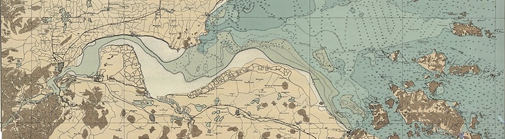
For the continuous numerical model, two GIS datasets—a topographic digital model and a bathymetric digital model—were merged to create a seamless depiction of the terrain both above and below the water. When seen in a satellite image, the “coastline” of the Yangtze Delta appears as a distinct line dividing water and land; the merged topographic / bathymetric model, by contrast, reveals the continuity of this terrain, showing the continuous gradient of the terrain’s surface and challenging the singularity of the divisive line at the coastal edge.

Satellite image of the Yangtze River Delta [left];
Merged bathymetric / topographic model of the Yangtze River Delta [right]
Images © Yangtze River Delta Project, 2013
This merged topographic / bathymetric model provided the surface onto which the statistical models of typhoon storm surge events could be mapped. Using surge heights for 250-year, 500-year, and 1000-year statistical storm models, the merged model reveals that many of the municipal districts around central Shanghai are low-lying areas at high risk of inundation. The Shanghai Edge Atlas, detailing seawall conditions and land use along the coast, was developed to establish coastal elevations on the continuous digital model.

Inundation risk maps of the Yangtze River Delta, showing 250-year, 500-year, and 1000-year flood plains. Images © Yangtze River Delta Project, 2013


Shanghai Edge Atlas, selected pages, including edge typologies, key maps, satellite imagery, and inundation risk. Images © Yangtze River Delta Project, 2013
The Open Polder
In the search for a design strategy for the Yangtze Delta proposal, one that would respond to both the risk of storm surge and provide new techniques for managing floodwaters, the research group was intrigued by the philosophy of Yu the Great (2200-2100 BCE, founder of the Xia Dynasty), who devised a protective response to the historically devastating floods in China through a moderate, soft infrastructural approach. Rather than building dams and high dikes to impede the flow of water, Yu created a system of irrigation canals that relieved riverine floodwaters into agricultural fields, building low earthen dikes to guide the water’s flow. Yu’s techniques allowed for the movement of water rather than its static impoundment through damming; these worked with the simple dynamics of a gravity-fed hydrological system to relieve pressure and reduce flooding [8].
The Yangtze River and its extensive flood plain has long been the site of an agricultural society in China which is dependent upon flooding. Low-tech techniques were developed to control the movement of floodwaters, and the strategic use of canal dredging and bunding for the capture of water for irrigation have been harnessed for rice paddy production for thousands of years. Bunding, the process of gathering of soil into low ridges to form the edges of stepped terraces, echoes at a smaller scale the sectional characteristics of the naturally formed chenier ridge. Floodwaters are engaged to irrigate the rice fields, and simple gravity flow within each field allows the irrigation water to descend thorough a series of carefully managed terraces. Canal building through trenching and berming was also employed as part of urban and rural planning technique in recent Chinese political history, a labor-intensive process involving the displacement of earth through the techniques of cut and fill and employing the use of the wheelbarrow [9].

Chinese rice fields near Beijing, 1920.
Image by Deutsches Bundesarchiv, #137-004023
The YRDP team examined Yu’s concept of the agricultural field as a flood overflow zone though the conceptual development of a “passive” polder. A polder is essentially an earthen embankment or dike enclosing a low-lying area of land. The Dutch are perhaps best known for their techniques of land reclamation and flood defense through the construction of polders, but the Chinese have also extensively employed poldering as a strategy for protecting agricultural lands within riverine floodplains, particularly along the middle Yangtze River. But the fully enclosed polder demands maintenance and often requires the expenditure of energy through mechanized pumping. An enclosed polder creates an artificial and self-contained hydrological zone; the polder’s only connection to water outside of its contained area is through a sluice or gate system. In the Netherlands, coastal marshes or bays were separated from the surrounding water by dikes, drained with pumps, and planted with reeds to speed drying via transpiration. The resulting dry land generally subsides, creating an area that is thus below the surrounding water level. During rain or storm events, a polder system must be mechanically drained of excess water by pumps to prevent flooding.
The “passive” or “open” polder proposed by the YRDP is conceptually more resilient than the fully enclosed polder; it does not fully encircle a territory and thus maintains a semi-enclosed area as part of the surrounding hydrologic watershed, avoiding issues of continuing subsidence. The open polder functions as a kind of temporary reservoir, designed to hold floodwaters and slowly release them via gravity. Rather than attempting to exclude floodwaters, the open polder system intentionally accepts overflow and provides a slow release of water.
In the Yangtze River Delta Project, low figural earthen dikes form these open polders by wrapping agricultural territories adjacent to major linear canals. Several simple physical models were constructed and tested with water to analyze hydrodynamic flow, given variables such as canal depth, angle of canal intersections, and low berm/polder perimeters with gravity outlets flowing toward canals. Conceptually, the open polder allows for the collection as well as the controlled release and outflow of flood waters. This strategy applies the principles of “controlled flooding”—collect, retain and release—rather than the traditional formula of “flood control,” which attempts to exclude all water.

Open polder water tank study model, clay. Images © Yangtze River Delta Project, 2013
Constructed Berms
The Yangtze River Delta Project design focuses on the Shanghai Municipality’s coastal delta districts of Pudong, Fengxian, and Jinshan, wrapping from north to south along the coast, along with the area just west of the mouth of the Huangpu River. To increase the resiliency of the Delta region, the Project deploys a low-tech but large-scale intervention of earthen berms, which serve to reduce damage from storm surge by attenuating wave energy, slowing wave velocity, and temporarily capturing floodwaters, allowing the waters to be absorbed and to recede slowly.
Constructed linear chenier berm ridges, arrayed both on- and off-shore, help to slow surge velocity and dampen wave impact. Highways are raised atop similar linear berms, which act as both surge buffers and elevated evacuation routes. Figural earthen berms, the open polders, wrap agricultural fields, creating two overlapping curved bands across the four coastal districts. Simple cut-and-fill techniques, here interpreted as canal and berm, are used together with the traditional Chinese agricultural irrigation techniques of rice paddy bunding and terracing. The proposed semi-enclosed polders, arrayed in two broad bands, serve to capture water that overtops the coastal seawall and the three major canals connecting the Huangpu River to the East China Sea. Rather than mechanically pumping out water as in the traditional Dutch polder method, waters are absorbed and released via gravity flow through the existing and enhanced canal network.

Yangtze River Delta Project site model.
Image © Yangtze River Delta Project, 2013. Photo by Jock Pottle
The “open polders” and chenier ridges are conceived as a decentralized, redundant, and locally managed system that is embedded in both the geological history and the agricultural landscape of the delta, and are intended to decrease the vulnerability of Shanghai to the risks of sea level rise and increased typhoon activity. The flood waters of storm surge from typhoons are slowed, captured, retained, re-absorbed, and allowed to retreat in a systematically controlled manner.

Yangtze River Delta Project site model, detail of highways (in yellow) and open polders.
Images © Yangtze River Delta Project, 2013. Photos by Jock Pottle
Adaptive Landscapes
The Yangtze River Delta Project, as a collaborative examination of flood risk in the rapidly-developing landscape of metropolitan Shanghai, attempts to broaden the role of infrastructural thinking at the estuarine scale. Land use and urban growth must address the natural systems of earth and atmospheric sciences as well as the economic potential of real estate and capital. Nature is part of the urban realm.
Coastal urban estuaries, whether the Hudson River estuary, the Mississippi River Delta, or the Yangtze River Delta, are dynamic sites. These sedimentary terrains, affected by atmospheric and hydrologic systems as well as shifts provoked by climate change, must be reconsidered at the infrastructural scale in ways that acknowledge both urban settlement, agrarian use, and natural forces. Our deployment of a strategic process of design conceptually reframes the estuarine configuration to create a more resilient and adaptive landscape, a system that dynamically responds to the risks of sea level rise and the increased vulnerability of the coastal environment.
The consideration of land as a continuous topological surface extending above and below the water is a fundamental premise of our research and design proposals. This land surface, wet or dry, may be reconfigured to attenuate the wave energy of moving waters and capture, retain, and release floodwaters. In our work on the Upper Bay of New York and New Jersey, this is achieved through a field of archipelago islands and by the delineation of protective zones through the use of linear reefs. Land can also serve to channel water, transforming its speed and velocity and allowing for the dynamic movement and deposition of sediment for land building, as we examined in our proposal for additional diversions within the Mississippi River Delta. Or, land may be reconfigured through a simple cut-and-fill process to create a chenier-like field of linear berms and figural polders to retain and reabsorb floodwaters, as is proposed in our Yangtze River Delta Project.
The adaptive landscape operates systemically in varied atmospheric, tidal, and storm conditions. We employ “soft” infrastructural techniques, which we define as multiple and iterative strategies that buffer, absorb, or temporarily retain flooding. Our design proposals for adaptive landscapes strive to enhance the quality of urban life and the resilient health of the estuarine environment, while protecting against the risk of flooding and acknowledging the dynamics of sea level rise.
Credits
YRDP Research Group: Catherine Seavitt, Guy Nordenson, Howard Stone, Ning Lin, and Michael W. Tantala
YRDP Project Coordinators: Kjirsten Alexander and Rebecca Veit
YRDP Princeton University Student Researchers: Carly De La Hoz, Adam Fisch, Jessica Luo, and Anthony Salerno
 Catherine Seavitt is an Associate Professor of Landscape Architecture at the City College of New York and principal of Catherine Seavitt Studio, an interdisciplinary practice integrating landscape and public infrastructure. Her research focuses on design adaptation to sea level rise in urban coastal environments, as well as rethinking landscape restoration practices given the dynamics of climate change. Seavitt is the co-author, with Guy Nordenson and Adam Yarinsky, of the book On the Water: Palisade Bay (Hatje Cantz, 2010), an infrastructural and ecological study and planning proposal for New York Harbor given the effects of sea level rise. This work served as the inspiration for the workshop and exhibition, Rising Currents: Projects for New York’s Waterfront, held at the Museum of Modern Art, New York, in 2010. She is currently investigating the history, processes, and ethics of the de-domestication of large herbivores for grassland restoration and land management.
References
[1] Lyman P. Van Slyke, Yangtze: Nature, History, and the River, (New York: Addison-Wesley Publishing Co., 1988), 23.
[2] Stefania Balica et al, “A flood vulnerability index for coastal cities and its use in assessing climate change impacts,” in Natural Hazards 64 (2012): 73-105.
[3] Emmi Yonekura and Timothy M. Hall, “A Statistical Model of Tropical Cyclone Tracks in the Western North Pacific with ENSO-Dependent Cyclogenesis,” Journal of Applied Meteorology and Climatology 50 (2011). Note that both typhoon and hurricane are regionally-specific names for tropical cyclones.
[4] Tong Jiang, Analysis of Flood Hazards in the Yangtze River Valley and Strategies for Sustainable Flood Risk Management, (Aachen, Germany: Shaker Verlag, 2000), 17.
[5] Elaine Kurtenbach, “Rising Seas Threaten Shanghai, other major cities,” U.S. News and World Report, October 18, 2009, http://www.usnews.com/science/articles/2009/10/18/rising-seas-threaten-shanghai-other-major-cities.
[6] Associated Press, “Typhoon Winnie Slams China as Taiwan Cleans Up,” Sun Journal, August 21,1997, 17C, retrieved http://news.google.com/
[7] Congbin Fu et al., eds., Regional Climate Studies of China, (Berlin: Springer-Verlag, 2008).
[8] See Records of the Grand Historian: Han Dynasty and Qin Dynasty, translated by Burton Watson, (New York: Columbia University Press, 1993).
[9] Kris De Decker, “How to downsize a transport network: the Chinese wheelbarrow,” Low-Tech Magazine, accessed December 29, 2011, http://www.lowtechmagazine.com/2011/12/the-chinese-wheelbarrow.html.