Aqueous Ecologies imagines a future for Willets Point, a derelict peninsula in Queens, NY, in which new ecologies, economies, and cultural identities of the city are intertwined with landscape-based solutions for wastewater management and treatment [1]. Rather than starting with a traditional masterplan, this project proposes a productive ecology of multi-trophic aquaculture (closed-loop fish farming) as a catalyst for urban development. A 50-year process for cultivating aquaculture and urbanism at Willets Point increases wildlife biodiversity and creates cultural and economic synergies over time, at both local and regional scales.
Infrastructural elements and systems for multi-trophic aquaculture—fish raceways, mussel beds and kelp groins—are designed for a range of site conditions using parametric tools. These adaptive elements serve as a polyfunctional urban underlay that supports aquatic ecologies while treating fish waste, storm water and grey water for multiple development density scenarios. The robust fertilizers that are produced from this form of waste management can be sold to regional agricultural lands and garden plots. Other profitable exports from this infrastructural system include edible kelp, mussels, and sea cucumbers, a delicacy enjoyed in adjacent ethnic communities such as Flushing Chinatown. The aim of this project is to reformulate landscape as “a sophisticated, instrumental system of essential resources, services and agents that generate and support urban economies” [2].
Aqueous Ecologies proposes wastewater infrastructure that is adaptive, polyfunctional, and publicly accessible. A variety of landscape-based solutions for the conveyance and treatment of residual aquaculture waters, stormwater, and greywater are employed throughout the site. At areas of high urban density, waters flow through hard and soft-bottom channels, from sidewalk swales to plaza basins. The alternating conditions of saturation and desiccation at these urban spaces fosters a dynamic range of recreational and commercial activities. At the littoral zone of Willets Point, the character of the landscape is quite different. Biotic succession and daily tide dynamics are evident in the expansive salt marshes, while kelp cultivation groins extending into Flushing Bay become armatures for sediment accumulation and spontaneous vegetation. Public access throughout this zone, via boardwalks that convey wastewater for treatment, allows for immersive cultural experiences.
Aqueous Ecologies offers hybrid landscapes that foster cultural identity through productive ecologies. Investment in soft and hard aquaculture infrastructure to initiate site development embeds a local economic driver in a process of urbanization, and enables unique connections to adjacent communities and regional ecologies. Willets Point can be transformed through landscape infrastructure that goes “beyond technical considerations to embrace issues of ecological sustainability, connection to place and context, and cultural relationships” [3].

Regional Sewerage and Wetlands: Combined sewer outfalls and centralized treatment plants line the coast of the East River and Flushing Bay, a low-lying area that was once an expansive system of wetlands. Willets Point is notable for its high water table and lack of centralized sewer system.

Emergence of Resilient Ecologies and Economies: The integration of different types of water at Willets Point fosters an increase in biodiversity and activates local and regional programs over time. Aquaculture becomes a foundation for an ecological urbanism.

System Scenarios – Strategies for Urban Interface: A range of system, scales and orientations are explored using parametric tools. Multiple scenarios of sewerage systems wetland locations, and building development patterns are explored.

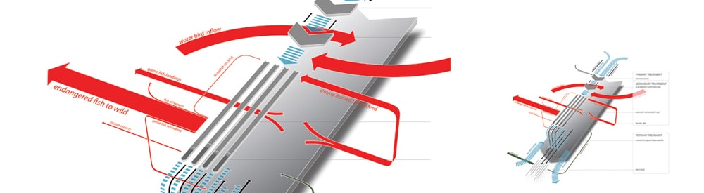
Willets Point 2060: By the year 2060, synergistic relationships between aquaculture and urbanism at Willets Point are mature: housing, commercial buildings, and streets at the core supply grey water and stormwater to the aquaculture industry, and four distinct versions of aquaculture infrastructure are deployed across the peninsula.

Intertwining Biophysical and Cultural Networks: Constructed ecologies of a productive aquaculture system are generative of urban expansion, while simultaneously reactive to scales of urban development.

Landscape in Flux – Daily Tide and the 100-Year Flood: Succession and daily tide dynamics are on display at littoral salt marshes, while civic plazas at the urban core detain and release storm and grey water, creating dynamic public spaces. The conveyance of water, waste processing, and the cultivation of aquaculture affect the development and operations of urbanism.

Corrugated Ground, Elevated Aquaculture: A robust urbanism at Willets Point requires a reworking of ground conditions, in order to convey, collect, and detain water, while allowing a system of roads with multiple scales of expression.
During storm events, public activities shift to elevated civic spaces that float above temporarily flooded civic spaces. The raised infrastructure connects to existing elevated transit lines and roof gardens and allows aquaculture and wastewater filtration to intertwine at multiple levels within the fabric of the city.

Sculpting Landscapes + Roofscapes: Low profile undulations in the landscape are designed to create perched ponds for recreational game fishing. Shed buildings are in dialogue with the landscape, nested into berms with roofscapes that extend the slopes of the angular landscape. The harvest, processing, and transportation of fertilizer from the aquaculture industry is embedded in the landscape.

Cultivated and Spontaneous Vegetation : Kelp thrives on aquaculture waste water and is cultivated within groins embedded in Flushing Bay, at the spatial limits of the water treatment system. The kelp can either be exported into culinary and medicinal economies, or processed into fish meal and turned back into the aquaculture system. In contrast to the cultivated kelp, spontaneous vegetation flourishes alongside the groins.

Emergent Habitat Islands: Sediment deposition and accumulation against the sides of groins and boardwalks that reach out into Flushing Bay lead to an emergent landscape of habitat islands accessible to the public.
 Michael Ezban is a licensed architect and partner at Vandergoot Ezban Studio. He has taught architectural design at the University of Michigan, Virginia Tech, and the Corcoran College of Art + Design. He is currently a Master of Landscape Architecture candidate at the Harvard University Graduate School of Design.
Michael’s work engages the production of waste and contamination remediation as generative urban processes. He was a Visiting Scholar in Architecture at the American Academy in Rome where he conducted research on the ancient Roman landfill Monte Testaccio, and in 2012 his peer-reviewed essay, “The Trash Heap of History,” was published in Places. In 2013 Vandergoot Ezban Studio’s design for Great Lakes dredging regimes, as adaptive public infrastructure will be published in the book “3rd Coast Atlas,” edited by Charles Waldheim, Clare Lyster, and Mason White.
Refrences
[1] This project was produced in the Harvard Graduate School of Design Landscape Studio Core III, coordinated by Chris Reed.
[2] Pierre Belanger, “Landscape as Infrastructure,” Landscape Journal 28. (Spring 2009): 79
[3] Elizabeth Mossop. “Landscapes of Infrastructure,” in The Landscape Urbanism Reader, ed. Charles Waldheim. (Princeton: Princeton Architectural Press, 2006),176.