The Australian population is increasing at a rate of one person every 84 seconds. All of Australia’s major cities; Brisbane, Sydney, Melbourne, Adelaide and Perth are forecast to double in population by mid-century. The Australian Bureau of Statistics (ABS) forecasts that by 2101 there could be 62.2 million Australians [1]. Taking this figure seriously means planning for an extra 40 million people by century’s end. And yet, the current collection of Australian planning documents go no further into the future than 2030 and only plan collectively for a mere 5.5 million additional people. There are (theoretically) some 35 million future Australians unaccounted for. Moreover, the planning that does exist is fragmented across state jurisdictions and subject to the short-term capriciousness of the 3-4 year political cycle. There is no national long term plan(ning) for the future of Australia’s settlement patterns.

All images by Richard Weller and Jullian Bolleter
This article offers a synopsis of the results of a two-year research project conducted through the Australian Urban Design Research Centre (AUDRC) regarding Australia’s future settlement patterns [2]. The project was conceived to encourage and inform broad public debate, influence planning policy settings and help foster long-term consideration of infrastructure spending from a national perspective [3]. It also proposes that landscape architects can speak to such large scale, long-term issues and add a much-needed perspective on strategic, long term urban design and planning. In order to prepare for future population growth, we argue for the promotion of population decentralisation through the application of broadband telecommunications and high-speed rail to create viable megaregions and in so doing enable Australia’s existing cities to avoid what would otherwise appear to be their inexorable slide toward becoming megacities sometime this century.
The primary reason for avoiding megacity status (cities of over 10 million people) is that despite their allure for tourists, designers and economic theorists, cities with very large populations rate poorly in global livability assessments [4]. For example, Los Angeles—a city that bears many similarities to Australian cities albeit at a larger scale—is currently ranked 44th in the Economist’s ‘Global Liveable Cities Index’. Similarly ‘great’ cities such London or New York come in at 53rd and 56th respectively. On the contrary, Melbourne is ranked 1st, Sydney 6th, Perth 8th and Adelaide 9th. The average population of the top ten most liveable cities on earth is 1.7 million. Although the rankings can be disputed and the variables are many, size it seems, does matter [5].

Figure 1 Cities and their 2056 Population Projections
The method and narrative of this research is this: first we map the spatial implications of ABS (high) population projections for each of Australia’s existing major cities. The ABS forecasts that in 2056 Brisbane could be a city of 5.7 million people, Sydney 7.6 million, Melbourne 7.9, Adelaide 1.8 and Perth 4.2. (Figure 1) By mapping these numbers onto each city in terms of their current infill and greenfield development targets we conclude that by mid-century, if not before, these cities will have reached their limits [6]. By ‘limits’ we mean the point at which their global livability ratings begin dropping due to infrastructure overload, environmental despoliation, congestion and social inequity. As now recognised by the federal government through its newly formed agency, ‘Infrastructure Australia’ (IA) the infrastructure of Australia’s major cities is already at capacity or overloaded [7].
Furthermore, population growth is now routinely blamed for problems in Australian cities and the community generally resists any attempts by planners to increase density. Around the nation the average target for infill development is 60 per cent of all future development and yet typically only 30 per cent is achieved. Much of this 30 per cent is comprised of small poor quality projects whereby individual home owners ‘cash in’ by building a second house in the backyards of quarter acre lots and in so doing erase the open space that made suburbia attractive in the first place. Despite this practice, Australian cities predominantly continue to sprawl and are thus increasingly committed to individual forms of mobility based on uncertain energy futures. It is true, however, that if well planned, increased density along major transport corridors, at transit hubs (Activity Centres) and around the edges of public open space millions of people could beneficially be added to Australian cities. But, according to our calculations, even if those areas were developed to higher densities so as to meet Australia’s forecast growth, there comes a point in time when those cities will have reached capacity beyond which further development is deleterious. We estimate that time to be towards the middle of the 21st century.

Figure 2 Areas for development
Accepting the likelihood that Australia’s existing cities will reach capacity by mid century—if not before—we then subtract the estimated total number of people forecast to be in these cities (42.5 million) by 2056 from the 2101 projection of 62.2 million. This leaves approximately 19.7 million people still unaccounted for. We then explore the question of where these people should best live through a process of mapping the nation’s landscape through the application of a set of key criteria. Whilst recognizing that the question of future settlement patterns can not be entirely reduced to an objective method, by scoring each criterion in relation to the national landscape we have been able to arrive at a hierarchy of landscape suitability. The key criteria analysed as determining the development potential of the nation’s landscape were: water availability, food proximity, climate (now and into the future), renewable energy potential, existing infrastructure, proximity to international markets, employment potential, natural amenity, cultural amenity, liveability indices, benefit to indigenous Australians, development feasibility, strategic military locations, humanitarian potential and national symbolism. Of course, each of these criteria is highly debateable but, be that as it may, we have been able to render our results transparent, accountable and most importantly, debatable with clear terms of reference.

Figure 3 Landscape attribute mapping
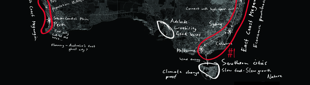
The method leads us to prioritize major development proposals for the southeast and the southwest of the continent. (Figure 2,3,4) The southeast is defined as an area stretching over 1300 miles from Brisbane in the north to Melbourne in the south, while the southwest is defined as 400 miles of the Swan Coastal Plain from Geraldton in the north to Busselton in the south. In these regions, we argue for the creation of megaregions, not megacities. There are approximately 40 megaregions in the world, the most famous of which is the economic and cultural powerhouse of Bos-wash (Boston to Washington) ‘discovered’ by Jean Gottman in 1961 in his study of the urban corridor from Boston to Washington in the Northeastern United States [8]. Following Tim Gulden, Richard Florida defines megaregions as contiguous lighted areas with more than one major city or metropolitan region, which produce more than $100 billion in LRP (Light-Based Regional Product) [9]. To date there are no megaregions in Australia.

Figure 4 West Coast and East Coast Megaregions, the landscapes best suited to absorbing Australia’s 21st century population growth
The development of megaregions requires the economic and cultural dynamism of large cities but also relies on constellations of smaller cities and towns. Joel Kotkin argues that, in the discourse of megaregions, the economic role played by smaller cities and towns has been somewhat overlooked [10]. Referring to a McKinsey Global Institute study, Kotkin notes that small cities (many under a million people) are responsible for more than half the world’s growth and, in the case of the United States, some 70 per cent of GDP [11]. Not only are small to mid-sized cities economically effective, they also offer their citizens a high quality of life insofar as they are relatively free from the social and environmental problems that typically beset large cities. For the middle classes, the lifestyle of choice seems to be: do business with the big city and visit when you will, but live in a healthier, more affordable, less congested and smaller one.
The populous megaregion should not just be seen as a large-scale development opportunity. Megaregional planning suggests a new conception of integration between landscape systems and infrastructure. A megaregion is best understood as a large-scale hybridisation of culture and nature, whereby the ecosystem provides the lineaments of settlement, where productive landscapes are responsibly cultivated, and renewable energy is harvested. This is not a platitude; this conception of the megaregion as a sophisticated, synthetic ecology is important, for it marks a departure from the historical image of nature as a mere backdrop to, or resource for the city. As Peter Calthorpe points out “[m]ore than standalone ‘sustainable communities’ or even ‘green cities’ we now need ‘sustainable regions’— places that carefully blend a range of technologies, settlement patterns and lifestyles” [12].
This conception also marks a departure from 20th century landscape planning from when Ian McHarg typically saw the city as a scourge on the landscape. In the emerging megaregions of the 21st century, people and their infrastructures could be the agents of stewardship. Here, we bring McHarg’s contempt for the city full circle. Whereas the dominant discourse of the megaregion to date has been one of economic optimisation, we are now advocating an economic and an ecological vision of megaregional development.

Figure 5 New City, East Coast Megaregion.

Figure 6 New City, East Coast Megaregion.
Neil Chambers captures this philosophical shift well when he writes, “[t]he end goal would be to have this revitalised region support tens of millions of people while producing natural niches for multiple ecosystems of native plants and animals to flourish and abound, where agriculture, infrastructure, and power production is integrated into nature in a way that enriches rivers, forests, economics, and communities…Biologists, engineers, ecologists, architects, zoologists, designers, hydrologists and a host of other disciplines would need to work together to restore multiple eco-zones” [13].
Technology and human nature is never so benign, but the worldview that human agency can be a constructive rather than destructive part of bioregions is the philosophical prerequisite for new material practices. Building on this premise, Harvard landscape ecologist Richard Forman has studied the range of ways in which human settlement patterns grow and their various impacts on the ecosystem. Forman’s conclusions support the development of megaregions of satellite cities, as opposed to the further sprawl of existing cities or linear development along roads [14].
In addition to people, the key to creating megaregions is high-speed telecommunications and high-speed rail [15]. With high speed rail and broadband telecommunications people can spread out but stay culturally and economically connected. By ‘spread out’ we don’t mean regional sprawl, we mean new, innovative cities designed in accordance with their landscape conditions that offer a diversity of lifestyle choices. (Figures 5,6,7,8)
High-speed trains over the scale of a megaregion make best sense when they stop no less than every 60 miles or so. When we apply this principle to the landscapes identified as best suited to megaregional consolidation we conclude that there could be a series of 17 new towns in the southeast of Australia and 8 new towns in the southwest. (Figure 9, 10) If, for argument’s sake 19.7 million people were to be divided evenly across these new cities then 25 new cities of circa 800,000 in each is the resultant distribution [16].

Figure 7 New City, West Coast Megaregion.

Figure 8 New City, West Coast Megaregion.
The population and immigration debate in Australia is vexed. On a recent visit to Australia the renowned population biologist Professor Paul Erlich remarked that Australians are “way beyond” the landscape’s carrying capacity and that in the future they “might have to evacuate” [17]. On the contrary, Harry Triguboff, a successful developer, has remarked that Australia should become a nation of 100 million [18]. Both these extreme positions seem inflammatory. For the purposes of this research we have accepted that in order to offset the nation’s aging population and supply its labour market Australia is almost certain to continue to grow for most, if not all of the 21st century.
Given that, the question at hand is not whether this growth is good or bad but how best to direct it. For us, accommodating population growth in a strategic and sustainable manner is a matter of spatial planning: a matter of landscape architecture at a large scale. As the nation’s preeminent demographer Professor Graeme Hugo says “…in the light of emerging environmental, economic and social trends the question must be asked as to whether, in a climate change context, the current settlement system will deliver the most sustainable, efficient and liveable outcomes for Australians over coming decades” [19].
To date Australian cities have been able to sprawl more or less unabated, but as sprawl becomes increasingly unsustainable and our major cities reach liveability tipping points, decentralisation is not a case of Arcadian planning theory so much as a looming economic and social necessity. On this, Sir Peter Hall is unambiguous: “society can have already overgrown cities getting bigger and bigger…or it can have regional planning” [20].
Landscape architecture in the late 20th century turned away from the instrumentality of ‘regional planning’. We think it is time to reclaim this territory and do so in a way that is part of a larger creative project of ecologically reorganising human systems.
Acknowledgements
Thank you to Steph Carlisle and Nick Pevzner for their helpful reviews and editorial development of this article.

Richard Weller is the Martin and Margy Meyerson Professor of Urbanism and Chair of Landscape Architecture at the University of Pennsylvania. Formerly he was Director of the Australian Urban Design Research Centre (AUDRC) and the design firm Room 4.1.3 known for the controversial National Museum of Australia. In addition to three books regarding his design and planning work, he has published over 70 papers on the intersection of ecology, art and design and given hundreds of public lectures around the world. Throughout his academic career he has received a consistent stream of international design competition awards at all scales of landscape architecture and urban design and was honored with an Australian National Teaching Award in 2012. Professor Weller’s current research concerns global conflict zones between rapid urbanization and biodiversity.

Dr Julian Bolleter is an Assistant Professor at the Australian Urban Design Research Centre (AUDRC) at the University of Western Australia. His role at the AUDRC includes teaching a master’s program in urban design and conducting urban design research and design projects. Since graduating in 1998 Dr Bolleter has practiced as a landscape architect in Australia and the Middle East on a diverse range of projects. In 2009 he completed a PhD that critically surveyed landscape architectural practice in Dubai and advanced scenarios for Dubai’s proposed public open space system. Julian and his colleague Richard Weller have recently completed a book entitled ‘Made in Australia: The Future of Australian Cities.’ The book scopes the urban implications of Australia’s population reaching 62.2 million by 2101.