As cities increase in scale and complexity, practitioners in design fields struggle to understand and direct the impact made by infrastructure on the urban environment. Since the early discussions of landscape urbanism in the 1990s, architects have looked outwards to other disciplines to provide clues for dealing with complex contemporary sites: for instance, to ecology’s ability to map and utilize dynamic systems and to landscape architecture for its ability to articulate a variety of ground conditions or address de-urbanizing and post-industrial sites, as exemplified by the Shrinking Cities projects [2]. While these fields have contributed significantly to our understanding of infrastructure at large, any architectural contribution to the discussion ought to draw upon the methodologies and strengths of the discipline.
For architects in particular, the definition of what might constitute an architectural approach to infrastructure remains somewhat unresolved since the effects of infrastructure at the architectural scale are almost absent from contemporary discourse and comprehension at the urban scale often focuses on the diminishing significance of form and boundaries — concrete architectural concepts — in the face of a system of networks and flows in the contemporary metropolis [3]. The project outlined below proposes to study the specific architectural and urban ramifications of infrastructural projects on the ground by applying architectural parameters to the city’s infrastructure: by returning to form, boundary and symbolism.

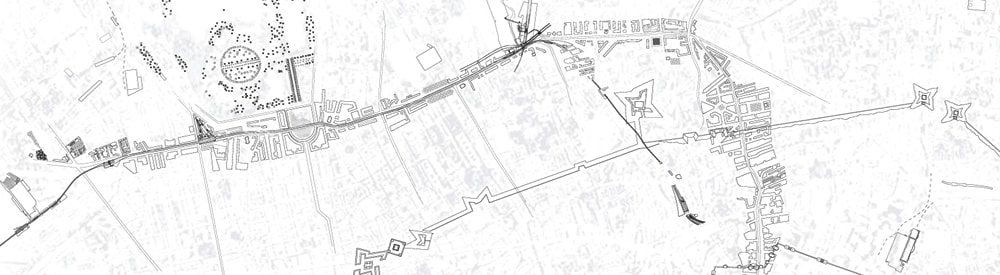
Skeleton Forms: Map of infrastructure projects in nineteenth-century London overlaid on top of Fortifications of London City by Joshua Carrelo-Mendez [1]*
These parameters are not new in themselves: for example, Aldo Rossi’s work on the form of urban artifacts [4], Kevin Lynch’s identification of symbolic characteristics in describing neighborhoods [5], and the design of large urban “island” boundaries by O.M. Ungers in his 1977 Sommer Akademie [6] are all attempt to use architectural language to describe urban conditions. This paper, and the student work that was produced in design seminars on the same subject, aims to extend these three principles to infrastructure.
Architects work by synthesizing a disparate array of information in order to produce physical form. The method of dialogue between architect, clients, consultants, and end-users broadens the scope of questions and helps determine possible solutions. The ability to convert diverse qualitative information into formal responses — to think architecturally — is a fundamental strength of architectural methodology, independent of the scale and form that this response takes [7]. As the most direct way to address basic human needs within a city (running water, a reliable supply of electricity, adequate plumbing and other services), infrastructure is usually part of this process, mediating between these questions and their architectural “answers.” As Reyner Banham stated in his 1965 essay for Art in America “A Home is not a House,” infrastructure acts as the agent between social life and the architecture that accommodates it [8]. It is infrastructure’s agency and its ability to act directly on the city that has been the focus of design seminars I have recently been undertaking with students at The Cooper Union and Cornell University. Infrastructural case studies were momentarily treated as discrete, symbolic forms, which allowed us to see them as actors that respond to and change the city around them. Viewing the city as a collection of infrastructural projects that mediate natural resources in order to supply urban needs re-frames the concept of “the city” into a complex site of social, political and economic forces.
Boundary, Form and Symbolism
In contemporary culture architects are commonly viewed as producers of icons. In the case of the iconic building, boundary, form and symbolism are concepts central to architectural discourse and are easy to discuss. The boundary is typically the line where the façade meets the street, separating architectural form from its less significant context. Form can be discussed by comparing one building to other buildings of a similar type: for example, by relating Mies van der Rohe’s Seagram building in New York to that of Bunshaft’s Lever House across the street, both being early examples of modern, curtain-wall skyscrapers. Symbolism involves the way the building communicates ideas about itself via its overall form or in its details: the continuity of floor surface from the plaza outside to inside allows us to read the lobby of the Seagram as an extension of the city, rendering the tower above a suspended slab hovering above Park Avenue.
The architectural parameters of boundary, form and symbol have also been used to identify and classify architectural artifacts at a larger scale [9]. Palladio’s projects for the Piazza dei Signori in Vicenza provide an early example. Taken together, the Palazzo della Ragione (1549-1614) and Palazzo del Capitaniato (1565-71) transform the piazza into an architectural object by redirecting focus onto the public space created between the buildings. In this case, the form is that of an urban space and is achieved through a number of similarities at its edges: in the columnar rhythm of the many facades, the details of the arched openings and their ground floor arcades. The previously empty void of the piazza is transformed into the object of study, achieving the same significance as what the buildings, as architectural objects, would normally hold. The boundary of this new, complex entity becomes re-drawn to include the architecture of the facades and arcades, as well as their context: the piazza itself. Henceforth the emphasis on architectural space over architectural objects becomes even more conspicuous in Renaissance urban restructuring.
Applying the parameters of boundary, form, and symbolism to the much larger scale of infrastructure is a greater challenge, but one that might allow us to understand more directly how agency is effected in the contemporary city. For example, the trajectory and form of street projects are shaped by the different political, social and economic factors guiding their implementation and thus reflect a particular urban culture. Streets are used as transportation and services infrastructure but they also give order to, and symbolize the culture of, a city. An exemplary model is Sixtus V’s street projects for Rome in 1585-90, involving a series of straight avenues that cut through medieval fabric to connect the monuments of the new Roma Christiana in anticipation of Jubilee visitors. This strategy becomes familiar in the nineteenth century: a street-turned-architectural space, lined with Baroque facades and enclosing monuments within its interior. However, a good comparison of how transport infrastructure gets implemented as architecture is between John Nash’s Regent Street in London (designed in 1811) and Baron Haussmann’s network of boulevards (begun in 1853). While both use a street to re-structure the city at a larger scale, cut visual corridors through a disorderly medieval town, control latent social unrest, and craft an expanded civic or imperial identity, the differences in their form are striking. The Parisian example is completely straight, benefitting from lenient eminent domain policies and weak private resistance to top-down planning. By comparison, the winding trajectory of Regent Street indicates something of the nature of private property rights in London, which did not allow for the kind of wholesale carving that Haussmann was able to achieve in Paris. Both employ neo-classical facades to fashion an identity for the street that symbolically represents the reigning power of their respective cities; however Nash’s reliance on private financial involvement meant that he had to accommodate multiple interests and different programs, which lends Regent Street a picturesque variety [10]. Haussmann’s adoption of neo-classical facades — already established by Percier and Fontaine in the design for the Rue de Rivoli in1802 and quickly associated with the Napoleonic Empire — is implemented without interruption throughout the network of boulevards in Paris, identical façades lining up one after another and articulating a continuous horizontal band that spans across buildings and unites them into a larger processional route.

John Nash, Regent Street, 1811

Baron Haussmann, Boulevard de Sébastopol, 1854
By applying architectural parameters to infrastructural projects, we gain insight into how specific projects act as players in a broader cultural environment. Rather than viewing — and designing — architecture and urban space as a layer that sits upon a neutral base of evenly-distributed infrastructural networks, we can assess how infrastructure is used as a vehicle for political, social and economic agendas. The design seminars at Cornell University and The Cooper Union did this by studying infrastructure projects architecturally: rather than approach infrastructure as solely a system (though it might behave as one) and a network (though it may be structured as such), the students were asked to look for the historical and formal particularities of their case study by defining a limited boundary of effects, analyzing their form, and discussing how the infrastructure adopted a symbolic role within the city.
Skeleton Forms: London
The research undertaken by the seminar class at Cornell utilizes this approach across scales by studying the relationship between the architectural object and the larger infrastructural influences of specific case studies in one city — London — in order to study their effect on the city’s growth. The project proposes that the infrastructural decisions of the city are determined by its political, social and cultural life, lying beneath the visible city like a skeleton structure. Instead of assessing the infrastructure of London as a network, something that assumes evenness in extension and application, this seminar’s approach asked students to analyze discrete case studies in order to create a composite image of the city through its individual, infrastructural, forms. The seminar asked: What determines the boundary of an infrastructural project? How does it overlap with other discrete projects and what part of the larger ‘network’ is adopted into the urban fragment?
Part research, part drawing, and part analysis, the results of the seminar give a picture of nineteenth-century London shaped by public-private infrastructural ventures. This period is particularly interesting because it represents an early stage of infrastructural development when monumental architecture was used to symbolize technology’s role in modernizing cities. The case studies were combined to create a composite map of the city and allowed students to discuss relationships between projects over time. Many conclusions can be drawn from this collective body of research. For example, we see how early private power stations converting coal into electricity on the banks of the Thames were a linchpin between coal mines developing throughout the United Kingdom and the small area of the city that benefitted from early lighting. In doing so, they also influenced the location of train termini that were receiving significant coal traffic. Above all, it reminds us of the lasting impact made by the walls of London long after their removal: they are the limit of early electrical distribution by the Bankside Power Station in London, they serve as an ethereal guide by which the termini of railways are located — lines of trade that extend out into England to bring goods into and out of the city. We find that the penitentiaries sit on top of, or beyond, the ghost of this wall, typical of nineteenth-century spaces of exclusion [11]. It becomes clear that the London Metropolitan Railway of 1836 — the first underground line — invisibly tracks the first omnibus route along the New Road, an early turnpike constructed in 1756 to bring cattle to the markets by bypassing central London; that breweries, consuming coal, water and grain in huge quantities, had to be located near wharfs along the Thames both to import this resources, but also to ship spent grain to nearby cattle farms and their products all over the country; and that the increase in prisoners in the nineteenth century produced prison hulks recycled out of navy ships that fostered relationships with industry, such as the Royal Arsenal that was run by prison labor. Above all, it reminds us of the lasting impact made by the walls of London long after their removal: they are the limit of early electrical distribution by the Bankside Power Station in London, they serve as an ethereal guide by which the termini of railways are located — lines of trade that extend out into Endland to bring goods into and out of the city. We find that the penitentiaries sit on top if, or beyond, the ghost of this wall, typical of nineteenth-century spaces of exclusion [11]. All of these relationships combine to create a collage that shows how London’s early infrastructural projects mediate between a pre-modern urban world visibly tied to its natural resources and the smooth, even networks of a modern industrial capital.
Throughout the project, which had been primarily focused on the history of urban form, a constant theme was how best to represent infrastructure. To accurately describe the infrastructural object meant locating it between inputs of various scales (raw materials in far-off mines or fields, sites of connection for transport, neighborhoods needing to be connected with banking centers or prison ships throughout the UK and its colonies) and outputs at the urban scale (electricity, beer, water, playgrounds). A consistent scale and type of drawing was impossible as the traditional methods of representation that apply to buildings could not grapple with the range of environmental effects. Likewise, a graphic abstraction of network diagrams could not effectively show how projects had reacted to specific events on the ground: forms of landownership, neighborly rivalries and local resistance or promotion. This problem became a recurring discussion in the seminar and reflects another fact of architectural methodology: as architects, we draw much more than we build. In order to find an architectural approach to the infrastructure that is so visibly a part of contemporary life, it is also important to ask how we can draw it.
Studying and drawing these models of public-private cooperation in infrastructure is especially instructive today, with the era of large-scale, government-funded initiatives fading behind us. The case studies give particular insight into how a project develops by accommodating private motivation, an agency that can be both productive and destructive, and deserves to be recognized as part of current practice and scholarship. By studying infrastructure through the lens of form, boundary and symbolism, architects can fashion a response that is both relevant to contemporary cities and truly architectural in nature.

Loren Rapport, Bankside Power Station and the Coal Yards of London, 1890

Miran Jang, Holborn Viaduct (partial), 1863

Rodney Bell, the London Metropolitan Railway, 1863

David Bibliowicz, the Lion Brewery, 1836

Ben Hoffman, the London and Greenwich Railway, 1836

Zuhal Kol, the West India Docks, 1802 -1973

Christopher Ray, Prison Ships and the Royal Arsenal works, 1840
*Acknowledgements
Combined drawing of London, Skeleton Forms: Map of infrastructure projects in nineteenth-century London, was created by: Rodney Bell, David Bibliowicz, Joshua Carrelo-Mendez, Yuriy Chernets, Lily Chung, Nicholas DeMaio, Shuning Fan, Ben Hoffman, Miran Jang, Taleen Josefsson, Zuhal Kol, Tzara Peterson, Loren Rapport and Christopher Ray.
 Laila Seewang is a practicing architect in New York City with built works in the United States and Australia. Her current research centers on theories of urban design, specifically the political and social effects of infrastructure throughout history. She has taught at Cornell University, The Cooper Union, GSAPP Columbia University, Princeton University, and Monash University in Melbourne, both in studios and in seminars on the history and theory of urban design. Previous experience in New York includes urban design at Pei Cobb Freed and Partners and architecture at Diane Lewis Architect, as well as prior experience in Australia. She has been published in Learning from Single Story Urbanism by Lars Muller, The New York Times and has exhibited at the Center for Architecture in New York.
Seewang received her B.Sc (environmental design) from the University of Tasmania, her B.Arch. from The Cooper Union, and her M.Arch. from Princeton University.
Refrences
[1] The fortifications of London City have played a major role in structuring urban development and, as such, provided a good reference by which other projects could be assessed. From the Roman walls, the Riverside and Blackfriars extensions, trenches added for communication during the Civil War, and, following demolition, the Ring of Steel in 1993 attempted to quell IRA and post-9/11 attacks and finally the Ring of Congestion in 2003, London City has continually re-defined its boundaries, from the visible to the invisible, providing an obstacle and guide for later infrastructural projects
[2] See for example Stan Allen’s discussion of artificial ecologies and information landscapes in “Urbanisms in the Plural,” Practice: Architecture, Technique and Representation (New York: Routledge, 2009): 159-191 and Grahame Shane’s seminal introductory essay “The Emergence of ’Landscape Urbanism‘: Reflections on ‘Stalking Detroit,’” Harvard Design Magazine 19 (Fall 2003/Winter 2004): 1-8.
[3] Lars Lerup concisely articulates the transformation of the traditional city into a metropolis that replaces boundaries and form for flows and networks in “Stim and Dross,” Assemblage 25 (1994): 82-101. Stan Allen elucidates the significant role of infrastructure in urbanism in “Infrastructural Urbanism,” Points and Lines: Diagrams and Projects for the City (New York: Princeton Architectural Press, 1999): 46-57.
[4] Aldo Rossi, The Architecture of the City (Cambridge: MIT Press, 1984)
[5] Kevin Lynch, The Image of the City (Cambridge: MIT Press, 1960)
[6] Oswald Matthias Ungers, et. al., “Cities within the City: Proposal by the Sommer Akademie for Berlin,” Lotus International 19 (1977), 82-97.
[7] Nigel Bertram and Marika Neustupny discuss the role of the architect in facilitating problem-solving for a variety of ills in rural communities in Australia. Ranging from management, event planning, landscape, and infrastructure, “architectural” solutions were only minor. Nigel Bertram and Marika Neustupny, “Sparse Urban Environments: Design Strategies for Possible Features,” in The Changing Nature of Australia’s Country Towns, ed. Maureen F Rogers and David R Jones (Melbourne: VURRN Press, 2006).
[8] Reyner Banham and François Dallegret, “A Home is not a House,” Art in America 2 (1965),70-79.
[9] See for example Aldo Rossi’s discussion of urban artifacts in The Architecture of the City, Kevin Lynch’s definition of “neighborhood” in The Image of the City, and the proposals for how to determine “island” boundaries based on urban character in Oswald Matthias Ungers et. al., “Cities within the city: Proposal by the Sommer Akademie for Berlin”, in Lotus 19.
[10] John Summerson, “The Plans and Elevations of John Nash,” in Georgian London (London: Pleiades Books, 1947), 160-173.
[11] See Michel Foucault and Jay Miskowiec’s description of heterotopic institutions such as prisons, cemeteries and hospitals and their removal to sites outside of the city, in “Of Other Spaces” Diactritics 16:1 (1986), 22-17.