Museum Of Lost Volumes

“Resource-making activities are fundamentally matters of territorialization – the expression of social power in a geographical form.” [1]
– Gavin Bridge


In the concluding section for his 1864 book, Man and Nature; or, Physical Geography as Modified by Human Action, American diplomat, philologist and conservationist George Perkins Marsh wrote: “it is a legal maxim that ‘the law…[does not concern] itself with trifles,’ de minimus non curat lex; but in the vocabulary of nature, little and great are terms of comparison only; she knows no trifles, and her laws are as inflexible in dealing with an atom as with a continent or a planet… [E]very new fact, illustrative of the action and reaction between humanity and the material world around it, is another step toward the determination of the great question, whether man is of nature or above her.”[2] In parallel, in his seminal 1967 study on the history of geographical ideas, geographer Clarence Glacken wrote that there have been three main geographic ideas since the Ancient Greece: the idea of a designed earth, the idea of environmental influence, and the idea of humans as geographic agents.[3] More recently, humans’ relationship to the earth is provided with an alternative narrative by debates on climate change as well as the idea of the Anthropocene, in which humans are now discussed as not only geographic but also as atmospheric and geological agents.

Correspondingly, in architecture and related design fields, contemporary conceptualizations for the idea of environment is presented either through the positivist overtones of management, efficiency and performance or through apocalyptic narratives of catastrophe and conservation. At this juncture, rather than seeing environment as something merely systemic, and therefore needing to be managed and maintained, or as purely natural, needing to be preserved and protected, can we instead talk about an alternative kind of geographic imagination in architecture that projects environment as aesthetic and monumental, and thus offer a renewed and a more nuanced dialogue between the representational and the material?[4] According to this formulation, geographic imagination would be a project about of a new kind of materialism that juxtaposes resource and matter with their seemingly opposing counterparts such as representation, monumentality and composition.

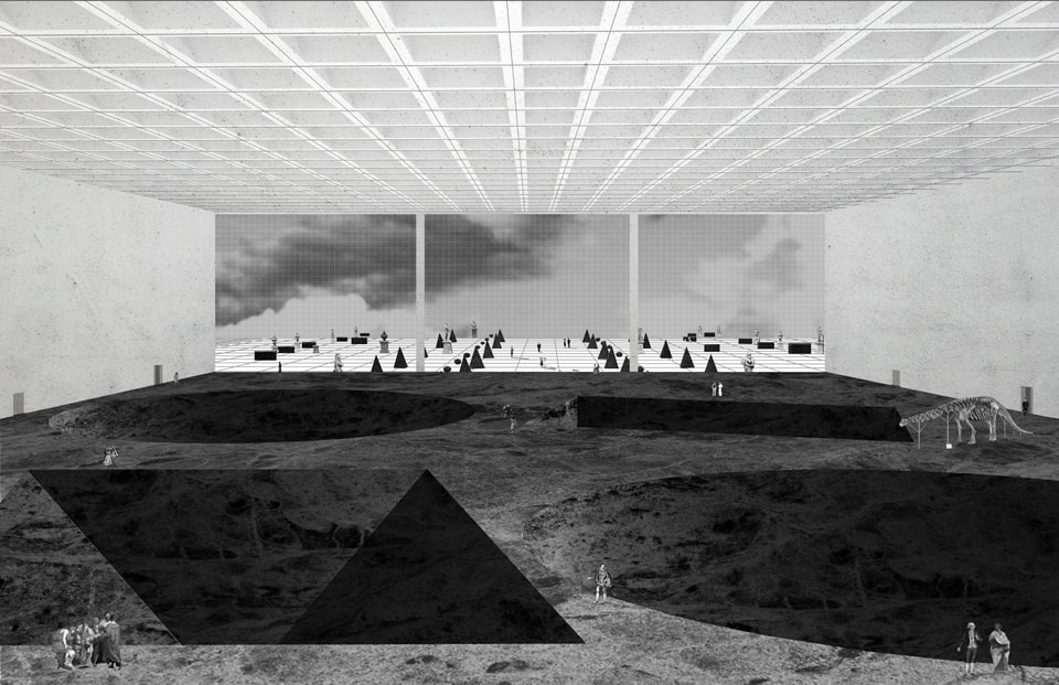
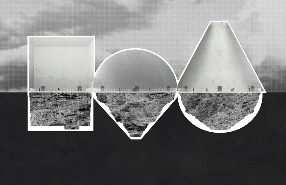
Museum of Lost Volumes project takes on this theoretical prompt as a starting point. As a geo-architectural fiction and a satire commentary on resource extraction, it provides an alternative focus on the mining of Rare Earth minerals. As a museum built after the depletion of Rare Earth minerals in the world after their abundant use with “green technologies,” it speculates on the preservation of geographic ruins that once belonged to the resource extraction of Rare Earth minerals mining. Since Rare Earth minerals are the backbone substance that is used in clean-energy technologies such as wind-turbines, electric batteries and solar panels, the project questions the idea of resource scarcity in the abundance of green technologies. It imagines a museum of ancient resource extraction ruins for a time when mining is an obsolete practice and treated similarly to an ancient monument or an extinct species to be housed in a museum. While rendering the geographic scale as a tangible entity, it aims to construct and alternative relationship between legibility and abstraction through the limits and potentials of design thinking. The project is comprised of five drawings, which all depict specific aspects of this imaginary museum.

While projecting on an unknown future era, Museum of Lost Volumes is slightly unfamiliar. In an attempt to expand the limits of our disciplinary imaginary, it employs familiar architectural strategies on what is considered to be unfamiliar within a disciplinary setting—in this case mining—and brings it into architectural consciousness. Perhaps in the same manner that Karl Friedrich Schinkel found beauty in the English factories, Walter Gropius in the American grain silos, and Le Corbusier in the ocean liner, it points to the ruthless territorial geometries of mining through architectural imagination. Rather than promoting a project of new realism—neither super realism (righteous scenario planning or environmental engineering of data) nor extreme surrealism (architectural sci-fi)—it aims to unravel the potentials of the unfamiliar precisely at the opposite end of the spectrum through abstraction. While speculating on humans’ relationship to the earth, it situates the idea of the slightly unfamiliar as an alternative positioning between the geographic and the aesthetic, while being strategically situated between legibility and abstraction.

1.

UNITED COUNCIL OF RARE EARTHS

Room1

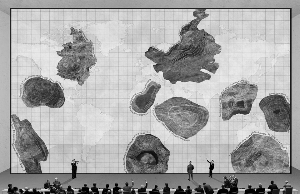
Once upon time in the Zero-carbon Hedonistic Era, the entire world was finally sustainable. Clean-energy technologies were abundant and ubiquitous. Large quantity of energy-efficient light bulbs, wind turbines, electric car batteries and solar panels would come with a price, however. Since all of these clean-energy technologies relied on Rare Earths—a group of seventeen chemical elements and their abundant extraction from the earth’s surface—significant worldwide increase in their demand led to the scarcity of these minerals. Nearly all of the Rare Earths were discovered in the 19th century but their use mostly proliferated in the Zero-carbon Hedonistic Era because of their association with green technologies. A report by the US Department of Energy, prepared back in 2011, had warned the world about this critical issue yet the danger was quickly forgotten soon after.[5] Not alarmed by the possible tragic outcomes of the further mining of these minerals, the world celebrated their delirious consumption with even more wind farms, car batteries and solar panels until very little of these minerals were available. Soon after the depletion of these precious resources were officially announced, in an attempt to prevent major geopolitical conflicts, United Council of Rare Earths was established to promote international co-operation regarding this matter.

In its inaugural meeting, the Council members drafted the text of the Declaration by the United Council of Rare Earths, which was signed by all countries. After a long meeting, the unanimous vote was held to ban further Rare Earth mining and to build a museum that would house and preserve remaining Rare Earth mines of the world, and would carry their legacy to future generations. The museum was named as the Museum of Lost Volumes.


2.

THE ROOM OF FLOATING VOLUMES

Room2

The Museum of Lost Volumes was composed of many rooms.  Each room was dedicated to different minerals while exhibiting a particular volumetric quality regarding these mines. The first room was divided into three parts and was connected with a single bridge that looked over the three different minerals. The bridge felt so small in this large space, and so did the visitors. While the mines were placed into the underground exhibiting the extraction processes of how they are removed from the earth, the visitors walked through the bridge observing them. The section profile of these colossal rooms was a monument to the mines as well, as they resembled the profile of a particular resource extraction. While walking along the bridge, the visitors felt as if they were floating in between the gigantic hollowness of the volume underneath and the massive spatiality of the ceiling above. Admiring the commemoration of these mines as volumes, visitors left the room completely mesmerized.

3.

THE ROOM OF SPECIES
Room3
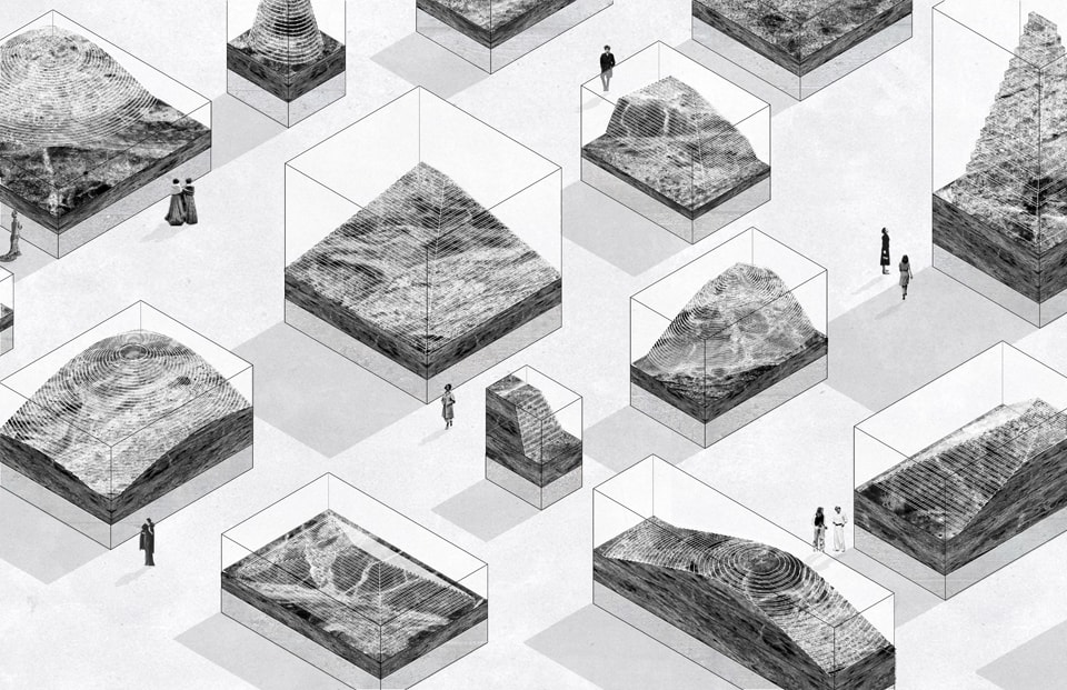
The next room of the museum showcased inverted pieces of Rare Earth mines from each of the seventeen mineral types that were placed carefully in preserved glass boxes. Varying in size, shape, and texture, each mine piece was filled with different stories and different lives. Visitors walked from one box to another, analyzing these glowing mountains so up close. One child put his nose up to the glass box, trying to get a much closer view to one of the minerals. “Why are these monuments trapped?” he asked to his mother. The mother looked thoughtfully. “If you are preserved and showcased, that means you are rare and very precious,” she said. “These monuments are actually at peace.”

4.

THE ROOM OF PLATONIC VOLUMES

Room4

The next room was a large continuous surface from which large platonic volumes were carved out. While each volume represented a particular Rare Earth mine in the world, the mine sizes were compared to one another in scale within the space of the room. Walking along the edges of these volumes, one visitor thought about the amount of neodymium extracted from one particular mine because of the sheer mass of the volume represented. “How many wind turbines would this make?” he said to himself. In this room, the represented lost volume was not bounded by a box or was to be viewed from a bridge like it was in the other rooms of the museum. Having the chance to walk on the actual matter and to be able to touch it was in itself a sublime feeling. The surface of the mineral felt smooth, but looked textured. The visitors were both astounded and heartbroken that these volumes were all lost from the earth’s surface.


5.

THE GRAND TOUR:

RARE EARTH REPLICAS

Room5

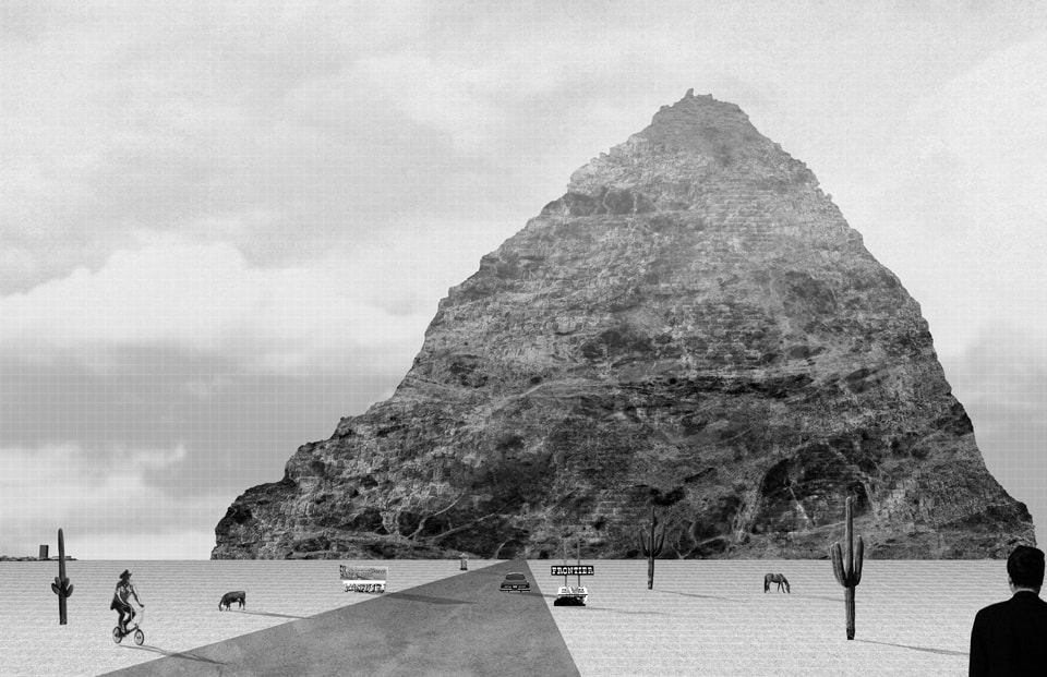
Last section of the museum was dedicated to the museum’s Grand Tour, an excursion of several 1:1 scale Rare Earth replicas. Since Rare Earth mines were too large to fit even in the specially constructed large rooms of the museum, these replicas had to be observed in the outdoors. Accordingly, in order for their total volume to be fully comprehended, the Rare Earth replicas needed to be seen from a far distance. Because of their colossal size, they were placed on a vast flat land. The distance of the replicas from the museum building were determined through the geographic distance to the visible horizon, approximately 2.9 miles from the entrance door of the museum for an observer standing on the ground with an average eye-level height. While all the replicas were inverted upside down reminding of the ziggurats from ancient civilizations, visitors took the Grand Tour to these geographic ruins to be terrified with their artificial magnificence. Millions of visitors would visit the museum and take the Grand Tour to these inverted monuments every year. When they went back to their homes after their visit to the Museum of Lost Volumes, they would be filled with admiration, anxiety and thankfulness for the resources of this rare thing called the earth.


Author’s note: Museum of Lost Volumes was awarded with an Honorable Mention in Blank Space Fairy Tales Space Competition in March 2015. Along with the other winners of the competition, the project has just been published in Fairy Tales: When Architecture Tells a Story Volume 2 (New York: Blank Space Publishing, 2015). The author would like to acknowledge and thank Anastasia Yee and Melis Ugurlu for all their help with the project.


Turan 144pxNeyran Turan is an assistant professor at Rice University School of Architecture, a co-founder of NEMESTUDIO, design collaborative based in Houston.  She received her doctoral degree from Harvard University Graduate School of Design (GSD) and holds a masters degree from Yale University School of Architecture. Turan’s work draws on the relationship between geography and design to highlight their interaction for new aesthetic and political trajectories within architecture and urbanism. She is founding chief-editor of the Harvard GSD journal New Geographies, and is the editor-in-chief of the first two volumes of the journal: New Geographies 0 (2008), New Geographies: After Zero (2009). Some of her recent writings have been published in Thresholds, SAN ROCCO, Conditions, MASCONTEXT, Bidoun, MONU, and ARPA Journal.


Notes:

[1] Gavin Bridge, “Resource geographies I: Making Carbon Economies, Old and New,” Progress in Human Geography 35:6 (2010): 825.
[2] George P. Marsh, Man and Nature; or, Physical Geography as Modified by Human Action (New York: Charles Scribner, 1864), 548-549.
[3] Clarence Glacken, Traces on the Rhodian Shore: Nature and Culture in Western Thought from Ancient Times to the End of the Eighteenth Century (Berkeley: University of California Press, 1967), vii.
[4] For a more extensive discussion on this question, see: Neyran Turan, “How Do Geographic Objects Perform?” ARPA Journal 03  (July 2015). Full article is available to view online at: http://www.arpajournal.net/how-do-geographic-objects-perform/
[5] US Department of Energy, “Critical Materials Strategy,” December 2011, http://energy.gov/sites/prod/files/DOE_CMS2011_FINAL_Full.pdf. Also see, Nicole Jones, “A Scarcity of Rare Metals Is Hindering Green Technologies” Yale Environment 360 (18 November 2013), accessed January 23, 2015.
 

Crossing The Line

Extraction and the Marcellus shale

While gas and oil-rich shale plays are scattered throughout the US, the focus of hydraulic fracturing (or fracking) in the East is an organic-rich, black and slightly radioactive Devonian shale called the Marcellus, which extends across Kentucky, West Virginia, Ohio, Pennsylvania and into the state of New York. A stone reservoir for an estimated 500 trillion cubic feet of natural gas buried one to two miles belowground, the Marcellus could be worth 1 trillion dollars to gas companies and landowners who hold mineral rights to the ancient rock formation [1].

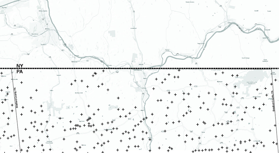
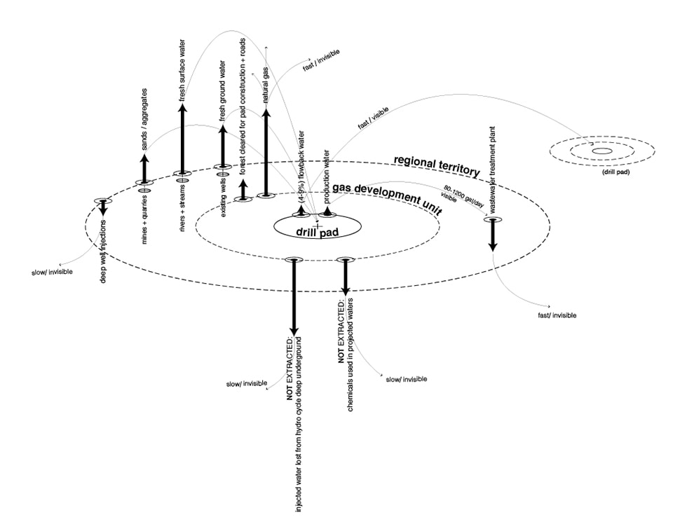
Like all mining practice, fracking is a process of extraction. Descending from a single drill pad located within a “gas development unit,” a vertical well can deploy many horizontal laterals, enabling it to extract gas from an area approximately one mile square. Large volumes of a pressurized slurry of water, sand, acid and chemicals is forced into the well, causing the shale to fracture and release its stored fuel, which is then brought back to the surface. Unlike more isolated mining sites such as copper mines or limestone quarries, the geography of the Marcellus extends across a large region, often consuming privately owned residential and agricultural lands. In order to tap what lies below, gas companies must first assemble an accessible surface via land leases and mineral rights purchases. Maps of the shale play area reveal a patchwork of leased properties interspersed with holdout tracts whose owners fear that drilling will expose them to noise and light pollution, truck traffic, land clearing, or contamination of well water and air. This holey matrix of extraction sits atop forest, field, river and town, and is not discrete and bounded, but rather must be fed by substantial inputs of materials from across the region. Its outflows produce both benefits (jobs, money, natural gas) and liabilities (wastewater, sludge, contaminants) for local residents.

Print

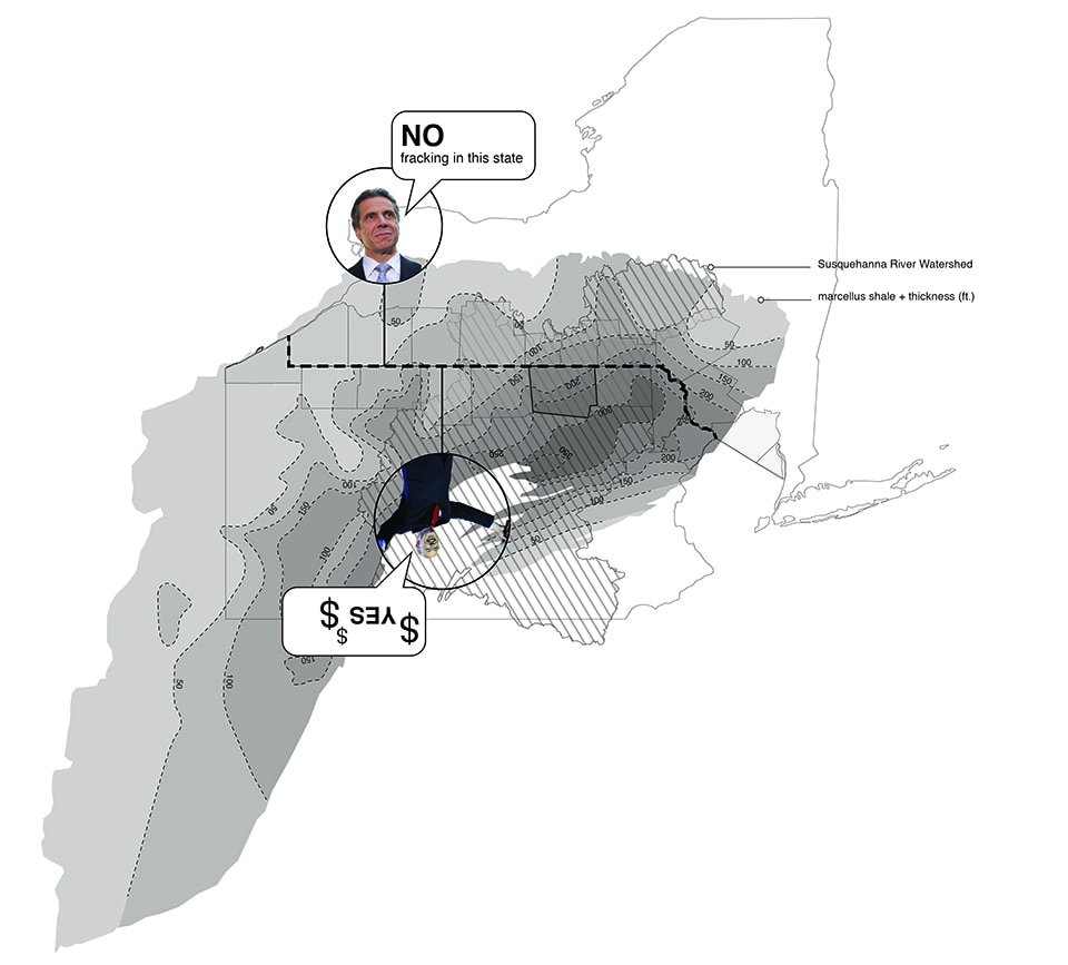
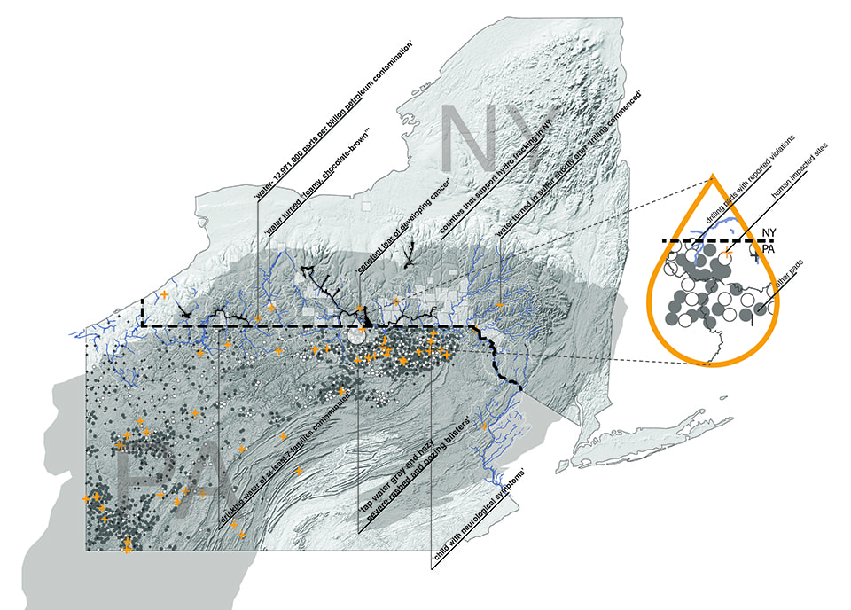
A line runs through it: The territory of gas extraction for the Marcellus shale underlays the watershed of the Susquehanna River. Bisecting the potential extraction zone is a policy line at the NY/PA border. Fracking is banned to the north of this line, while drill sites cluster just south of the border in places like Bradford County, PA.  


Drawing a Line

On December 17, 2014, Governor Andrew Cuomo banned the process of hydraulic fracturing for gas production in the state of New York, citing potential environmental and health risks and uncertainties [2]. Just south of the NY/PA border, some of the most intensive drilling occurs in an area where the Marcellus shale is deep, thick and most productive. A visit to northern Pennsylvania, where frack pads are a stone’s throw from “protected” New York lands, is a pleasant drive through rolling hills, farmland and forest. The pads are surrounded by chain link fence, each one rather inconspicuous but growing in presence due to their abundance: drilling pads begin to appear behind barns and on grassy knolls, until there seems to be a pad around nearly every bend in the road. Sightings of pipelines and meter boxes, storage tanks, new gravel access roads and tanker trucks collectively construct a stealthy industrial landscape emerging amidst these sleepy farm pastures.

After years of stalls and scientific studies, documentaries and lobbyists, 55% of New Yorkers breathed a collective sigh of relief with Cuomo’s sudden announcement of a fracking ban [3]. But how powerful is a policy line? Heading home from a Pennsylvania drill site behind a tanker truck as it crosses the border into New York without fanfare, one wonders about the power of this ban, this border. Where is this regulatory boundary solid and strong and where is the line blurred, perforated, or not really there at all?

02_FrackFarms

A graded drill pad sits nestled on a small knoll amidst pastures and farm fences. (Photo by Dylan Hartung)


Flows and Lines

Water Flows: It takes between 4.1 million and 5.6 million gallons of water to frack a single Marcellus well [4]. While the usage of recycled water by gas producers is on the rise, it is still small compared to the amount of freshwater that must be extracted from surface or groundwater sources, rarely topping 15% of the total water needed for the fracking operation [5]. Water is typically trucked to well sites in water tankers from around the state and from across the border. In a decidedly anti-extractive process, the water/sand/chemical mixture is forced into the well, and only a small percentage (between 4% and 9% for Bradford County wells) returns to the surface as “flowback”, wastewater that returns to the surface during the drilling of a well before it has begun producing. Between 2008 and the beginning of 2013, 6 billion gallons of surface and ground water was injected into the ground in the Pennsylvania portion of the Susquehanna River basin alone [6].

NYPAborderWells

Just across the line: A snapshot of the NY/PA border at Bradford County, Pennsylvania reveals the density of drill pads just south of the border.


Most of this water is pushed so deeply underground that it is effectively removed from the hydrologic cycle. The 80-1200 gallons of production water that returns daily over the life of the well is a briny mix containing chemical additives along with various constituents of the shale, including salts, organic pollutants, and radioactive ions such as uranium. This wastewater must be managed on site in storage ponds and tanks, trucked to municipal wastewater or industrial facilities, or sometimes injected deep into retired wells. Questions have been raised about the ability of Pennsylvania wastewater treatment plants, designed to handle human sewage, to rehabilitate the flow of 2,564,700 gallons of frack wastewater every day [7]. Further, these plants discharge “treated” waters to rivers throughout the state, including the Susquehanna, in an efficient distribution network for any remaining contaminants, including radioactive ions. Wastewater brine has even been distributed on New York’s roadways to prevent icing in winter [8].

ben_map

The amorphous underworld of water: Groundwater continuously flows and seeps, operating by its own rules and ignoring political boundaries on the surface. Following the laws of pressure and potential, groundwater can accelerate when passing through unconsolidated sediment or slow and pool as the substrate tightens. It can flow significant distances in days or remain underground for many thousands of years. It can rise to the surface as a spring or intersect with surface waters to feed streams, wetlands or ponds. Rural water wells in NY and PA rely on shallow groundwater and typically do not exceed 500 feet in depth. To access the shale, producers must drill through these shallow aquifers and then line the well with concrete to provide a barrier between fracking fluids and drinking water just inches away. This concrete casing is key to preventing the migration of chemicals and methane into groundwater, from where it could enter rural wells, pipes and kitchen sinks. Drillers claim that well water is safe, although a quick scan of pad violation notices reveals numerous surface spills, illegal dumping and concrete casing failures. Signs of trouble are sometimes only revealed when we turn on the tap.


Material Flows: Hydraulic fracturing requires the construction of a support infrastructure that includes access roads, two-acre concrete drill pads, storage tanks, ponds and pipelines. Flows of sand, gravel, stone and cement sourced from nearby quarries are required to build a network that will carry thousands of tanker trucks and drilling equipment for years. Sand is also a key component of the injection fluid, 12-14% by volume or over 65,000 cubic feet per well. Sand is used as a proppant during fracking to hold fissures open and help the gas to flow. Fine silica sands have become the preferred proppant of the fracking industry, implicating territories as far away as Minnesota, Wisconsin, and Illinois, where agricultural and forested land that sits atop silica sand deposits is being displaced in favor of vast sand mines. This other extraction landscape in the Midwest is set to grow as fracking operations in the Marcellus shale, as well as in other shale plays in the US, continue to accelerate.

The primary way to move these materials to drill sites is via truck. This incredible hauling of materials, water, and wastewater around the region means that dump trucks, tractor trailers and tankers (2300-4000 per well site) [9] are one of the most visible and constant flows associated with gas production in the Marcellus shale play. In the creation of fracking’s access infrastructure, Pennsylvania’s forests have seen extensive collateral damage. Aerial imagery just south of the NY/PA border makes plain the extent to which the drill pad/access road network has shredded forest cover in this region, exhibiting “a greater impact on natural ecosystems than activities such as logging or agriculture” [10]. With the danger of subsequent erosion and the impact on water regimes that forest losses pose, the access network may leave an even larger impact on the watersheds of Pennsylvania over the long term.

Print

burnsExtractDrawing960_08.18n

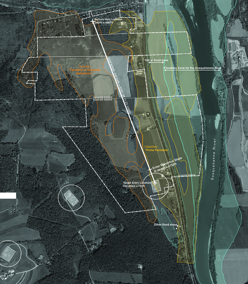
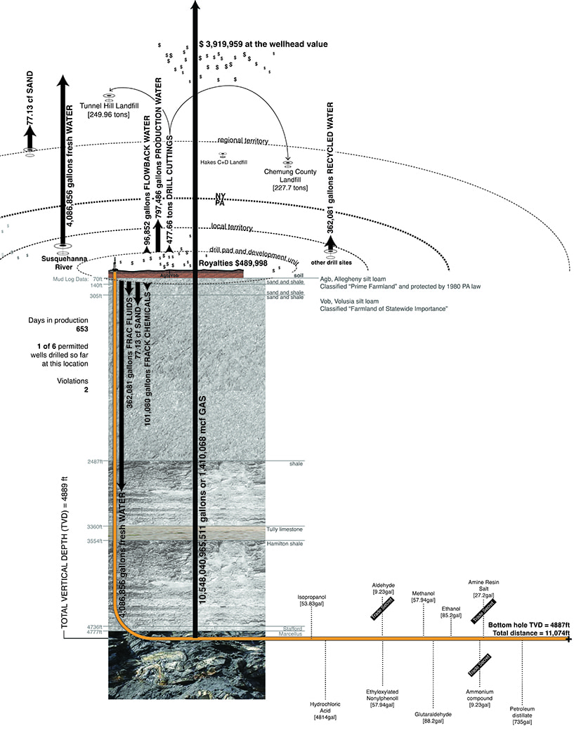
Drawings collect and organize disparate bits of data to assemble the flows of one drill site in Bradford County, PA. Here the first of 6 permitted wells is located on prime farmland soils, near the floodplain and channel of the Susquehanna River. 5,127,318 gallons of fluid were used to frack this well, including 4,086,856 gallons of freshwater withdrawn from the Susquehanna. The drill descended 4777 feet before entering the Marcellus shale formation, with drill cuttings removed from this location trucked across the NY/PA border to be disposed of at the Chemung County and the Tunnel Hill landfills in the southern tier of New York State. After 653 days in production, this site had produced 1,410,068 million cubic feet (MCF) of gas worth $3,919,959 at the wellhead, translating to $489,998 in royalties for the landowners within the unit.


Money Flows: The line does mean that landowners on the New York side will not profit from gas that could have been produced on their properties (although many have already benefited financially via gas leases). Reports have shown that Cuomo’s ban eliminated 50,000 potential jobs tied to the fracking industry. In Pennsylvania gas drilling has generated approximately 229,000 jobs, $2.2 billion in tax revenues so far. Initially most jobs went to out-of-towners from the industry, but increasingly, in-state residents are being trained to work in gas production. Businesses supporting the industry, such as restaurants and hotels, are also prospering. The power of the line is perhaps most potent and its effects most palpable when blocking the flow of gas royalties in New York. As Karen Moreau, the executive director of the New York State Petroleum Council puts it “Our citizens in the Southern Tier [of New York] had to watch their neighbors and friends across the border in Pennsylvania thriving economically…It’s like they were a kid in a candy store window” [11].

Print

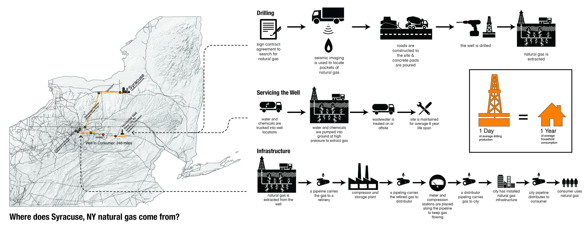
Flowing freely across the line: infrastructural connections, direct to consumers. Ideologies aside, consumers in NY still reap the benefits of having drill sites just next door. In fact, the price New Yorkers pay to heat their homes has fallen steadily since 2008 [12] as gas production has increased in Pennsylvania. The fact that natural gas is a local market means that as local production increases, local prices fall [13]. It can be difficult, if not impossible, to trace the flow of the gas used to heat a home in Syracuse, NY back to its source. National Grid, the New York home electric and gas company, purchases its gas from distributors and can’t (or won’t) tell a customer for certain where their gas originates. A dense network of pipelines (shown here in gray) both collects and distributes natural gas throughout the region. This gas typically does not require refining, so the fuel can flow fairly freely from drill site to home furnace. We trace one possible pathway from a drill pad in Rome township, to a storage facility 246 miles, to one of the authors’ homes in Syracuse. 


The landscape of extraction constructed by the process of hydraulic fracturing of the Marcellus shale is a special case. Nowhere else in the US do we see mining practice sharing territory with multiple parallel landscape systems, from watersheds and water flows, to habitats and species migrations, households and drinking water, extensive farms and working forests. Fracking draws large material and human inputs from a regional geography freely across borders and legislative lines. Its outflows likewise extend back out to the region and beyond, along existing regional infrastructures and natural systems. The flows of fracking can be fast (such as the influxes of industry personnel) or exceedingly slow (deep subterranean water flows). They can be visible (trucks, jobs, money) or invisible (groundwater pollution, cumulative contamination downstream). The power of a policy line at the NY/PA border varies greatly. The line is weak when it seeks to block flows that are unregulated, uncontrollable, or unseen: deep groundwater, injected water, truck traffic, jobs, land speculation, gas, illness, political ideologies, complaints and perceptions.

We are accustomed to living within a set of visible surface systems: hedgerows and cornfields, mowed utility easements and fenced property lines. But so much of the process of fracking is undisclosed: neighbors’ leases, health complaints, tainted wells, chemical lists and wastewater disposal sites have been concealed due to legalities. The connection between people and the extraction process occurring in their backyards and home places is obscured because most of it occurs behind closed doors and underground, in the alien, dark world of rock and soil, groundwater flows and methane migration. While producers can’t legally extend wells under unleased lands, would anyone know if they did? How does a landowner really know what is happening 2,000-8,000 feet underground? While the surface drill pad site is undeniably noisy, dusty and brightly lit, public knowledge of subsurface drill pathways only exists on the survey plat or engineering drawing as a plan, proposal, or promise.

Although drilling companies are increasingly pressured to release details previously considered proprietary, this information is scattered, buried and sometimes requires fees to access. Every drill pad has a specific and living dataset that includes a driller’s mud log, associated water withdrawal sites, mineral rights leases and contracts, and letters detailing tainted drinking water wells, waste water recycling sites, drill cutting disposal locations, gas produced, royalties paid, frack chemicals used and distances from drill pad to nearby drinking water wells. Mapping and visualizing the processes of gas drilling makes visible the flows that are normally obscured. It brings to light processes that occur below ground, without notice, or without public access. As more information is disclosed and made accessible, drawing and spatializing the complex and scattered bits of data is essential in order to construct a fuller understanding of a dispersed landscape of extraction and its hidden impacts.

jvanuuch_fracking

The flows of fracking: Risks associated with the process of hydraulic fracturing are often related not to what comes out, but what goes in and stays in. A large percentage of injected slurry, along with its suite of chemicals and carcinogens, never returns to the surface. Fracking in Pennsylvania has reportedly forced 1% of the state’s total surface waters downward and out of the hydrologic cycle for what may be millennia [14]. Meanwhile wastewater that is extracted at the surface must be either treated with ill-equipped infrastructure and released to surface waters, or pumped into deep wells. Flows vary from the fast and visible to the very slow and unseen.


VanucchiJamie Vanucchi is an assistant professor in the department of landscape architecture at Cornell University (previously SUNY-ESF). This work was prepared with students of the SUNY-ESF Design Lab for NY Waters, including: Ben Boisclair, Gena Morgis, Emma Oakes, Amy Allen, Kimie Case, Liz Grades, Rose Helmer, Chris Kraus, Billy O’Brien, Emma Oakes, Victor Prieto, Chris Rurkowski, Rachel Scudder.


Notes

[1] Penn State Marcellus Center for Outreach and Research, “How Much Natural Gas can the Marcellus shale produce?,” accessed August 6, 2015, http://www.marcellus.psu.edu/news/PDFs/gasreserves_day.pdf.
[2] Thomas Kaplan, “Cuomo Bans Fracking, Saying Risks Trump Economic Potential,” New York Times, December 18, 2014.
[3] Scott Waldman, “Poll: New York Voters support Cuomo’s Ban on Fracking,” Politico New York, Dec. 22, 2014, http://www.capitalnewyork.com/article/albany/2014/12/8559092/poll-new-york-voters-support-cuomosban-fracking).
[4] Evan Hansen, Dustin Mulvaney, and Meghan Betcher, “Water Resource Reporting and Water Footprint from Marcellus Shale Development in West Virginia and Pennsylvania,” prepared for Earthworks Oil & Gas Accountability Project by Downstream Strategies and San Jose State University (2013): 9, http://www.downstreamstrategies.com/documents/reports_publication/marcellus_wv_pa.pdf.
[5] This percentage based on author’s review of well reports for Bradford County.
[6] Hansen, Mulvaney, and Betcher, 58.
[7] “Marcellus Shale wastewater: Current discharges,” Pittsburgh Post Gazette, March 13, 2011, 7, accessed August 6, 2015, http://old.post-gazette.com/pg/pdf/201103/20110313marcellus_discharge.pdf.
[8] David L. Shaw, “Farmer objects to fracking brine on roadways,” Finger Lakes Times, November 18, 2014, http://www.fltimes.com/news/article_6cfb4e7a-6f33-11e4-870b-0bbc03e63e9f.html.
[9] Mary Ellen Cassidy, “Here They Come Again! The Impacts of Oil and Gas Truck Traffic,” September 11, 2014, FracTracker Alliance, http://www.fractracker.org/2014/09/truck-counts/.
[10] “U.S. Geological Survey: Natural Gas Fracking Is Destroying Pennsylvania Forests,” Oct 24, 2012, Natural Gas Watch, http://www.naturalgaswatch.org/?p=1565.
[11] Kaplan.
[12] Jesse Emspak, “How Fracking Affects Natural Gas Prices,” August 8, 2014, Investopedia, http://www.investopedia.com/articles/markets/080814/how-fracking-affects-natural-gas-prices.asp.
[13] Ibid.
[14] Hansen, Mulvaney, and Betcher, 10.


Contested Landscapes: Staking Claims In Michigan’s Copper Country

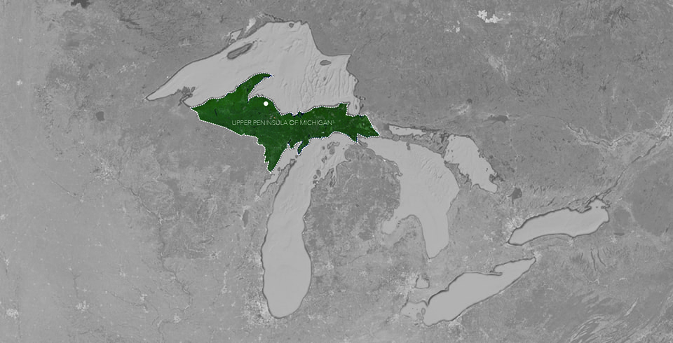
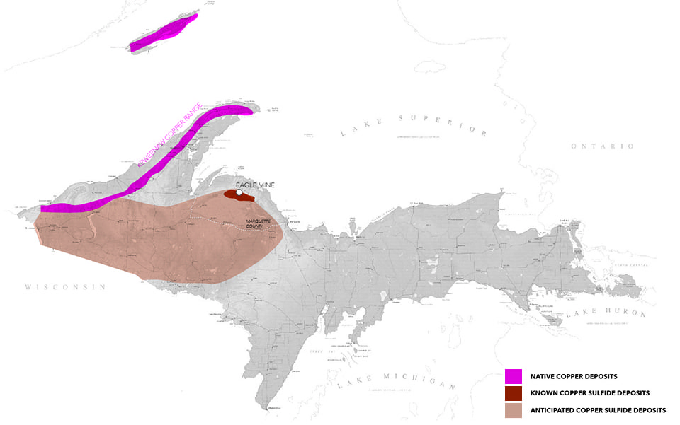
In 2002, transnational mining company Kennecott Minerals discovered a rich body of copper sulfide ore below the forests of Marquette County, near the shores of Lake Superior. Although the region has a strong history of copper mining, new and proposed mines in Marquette County harvest toxic copper sulfide instead of the native (pure) copper of the Keweenaw range [1]. In spite of the fact that the Keweenaw Peninsula has the world’s largest deposit of native copper, and that copper mining was the region’s main economic driver for over a hundred years, the copper mining industry largely left Michigan’s Upper Peninsula in the mid-twentieth century when the mines were no longer profitable. However, the discovery of an accessible copper sulfide lode in Marquette county in 2002, combined with rising copper prices, has led to a return of copper mining interests to the region. When the Kennecott Minerals Company requested to lease mineral rights for the construction of Eagle Mine from Michigan’s Department of Natural Resources (DNR) in 2007, a number of groups stepped forward to contest this landscape claim. This essay delves into the politics of this dispute and explores ways in which the concerns of each group are tied to a view of nature, natural resources and appropriate use of the landscape.

The introduction of copper sulfide mining ignited fierce public debate over landscape value and appropriate use of public land in Marquette County. In 2008 the Keweenaw Bay Indian Community (KBIC), which claims Eagle Rock as a sacred site, launched three state and local cases against Kennecott questioning the legality of their mining permits.

PrintPrint

Upper Peninsula of Michigan [top];
Upper Peninsula of Michigan Copper Deposits [bottom].

Map Data: Google [top]; bottom image by Elizabeth Yarina


The KBIC was joined in the lawsuit by a diverse group of local organizations, each with their own perspective on landscape value. For the Keweenaw Bay Indian Community, the narrative is one of heritage, where cultural values are closely tied to the elements of earth, water, plants, and animals. The Yellow Dog Watershed Preserve (YDWP) claims landscape value through narratives of biodiversity, hydrology. For the exclusive members of the Huron Mountain Club, “untouched wilderness” serves as an exclusive mark of status and as a luxury commodity. While anti-mining groups may operationalize, value, or describe aspects of the landscape in different ways, opposition to the Eagle Mine aligns groups who otherwise have little common ground to stand on. These strange bedfellows brought the case all the way to a federal appeals court before ultimately failing to stop the construction of the mine.

In Depoliticized Environments, Erik Swyngedouw argues that in the era of the Anthropocene, Nature has become de-politicized, with decisions about land management falling largely “outside the field of public dispute, contestation, and disagreement” [2]. In this work, Swyngedouw calls instead for a re-politicization of nature that allows for complex conversations about contemporary ecological threats. In the case of Eagle Mine, such a debate has been made public through lawsuits and public discourse, allowing a depiction of nature that isn’t reduced to a single-dimensional object for consumption or preservation. Instead landscape is represented through a diverse collection of voices, becoming a richly conceived “object of concern” [3].

Print

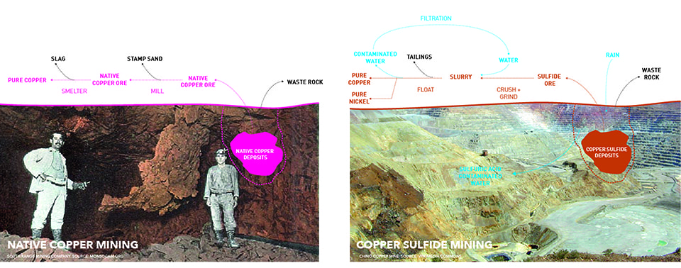
Copper Processing: Native Copper Vs. Copper Sulfide. (Image by Elizabeth Yarina)


A Continuously Modified Landscape

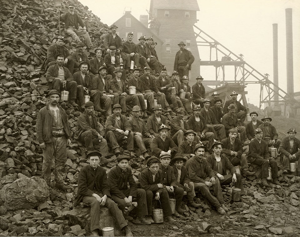
The Keweenaw Peninsula has the world’s largest deposit of native copper—a rare naturally occurring pure mineral form compared to the copper sulfide and copper oxide deposits found in most other copper mining districts—and the area became a major commercial producer of copper in the 1840s. The depth of its fissures and its incredibly large veins, however, make the extraction of Keweenaw’s native copper a laborious process, requiring it to be chiseled out of the surrounding rock and broken down into manageably-sized pieces.

Prior to the arrival of European settlers, the Michigan’s Keweenaw copper lode was mined by Native Americans as early as 5,000 BC, and its copper was found across the continent as a trade good in the form of jewelry, tools, and decorative objects [4]. It was through Ojibwe legends that word of Michigan copper reached the first explorers and missionaries to the region. Broad and shallow Native American pit mines later became the first successful mining sites for entrepreneurial settlers [5].

These early settlers saw the landscape as one to be tamed and consumed. Henry Schoolcraft, who called the Upper Peninsula the “ends of the earth,” was in 1921 the first to recommend large-scale exploration of copper deposits, leading to the division of the land by the US government into 9 square mile (and eventually 1 square mile) parcel units for mining activities. The land was ceded to the United States as part of an 1842 treaty with the Ojibwe tribe. With the land now bound and divided, early miners began clearing forests and blasting surface deposits, leading to the 1844 Copper Boom.

04-TamarackMiners

Tamarack Copper Mine, Tamarack, Michigan. (Photo courtesy of Keweenaw National Historic Park Archives)


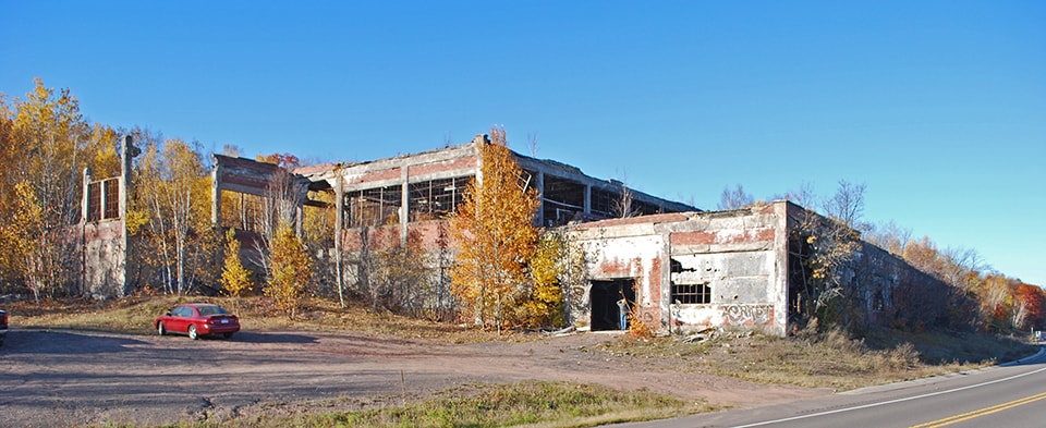
Early manipulations of the landscape in the name of mining included the dredging of Portage Canal, laying of railroads and highways, logging for building and fuel, construction of company-built housing and schools, and the building of mines and smelters [6]. Despite the fact that the Keweenaw copper lode is highly pure native copper, it still must be separated from attached hard or molten rock, producing stamp sands and slag. These stamp sands remain highly visible in the landscape of the Keweenaw today, resisting re-vegetation due to high concentrations of heavy metals, which continue to be dangerous to human and animal health. The built relics of the mining boom also continue to define the region’s landscape, alternately hailed as historical cultural landmarks or attacked as dangerous and toxic ruins [7].

Mining is not the only force that has shaped the landscape. While the Upper Peninsula is 80% forested, it is very much a curated and managed landscape. Logging is a major industry and outdoor sports are important to recreation and tourism. In the Michigan Northwoods, everything from forest composition to deer population is regulated by economics and policy.

05-Michigan Smelter06-Quincy Mining Company Stamp Mills

The Keweenaw Waterway and Michigan Smelter near Houghton/Hancock Michigan (between 1900-1906) [top]; Quincy Mining Company Stamp Mills Historic District, Houghton County, MI [bottom].
(Photos by Detroit Publishing Co. [top]; Andrew Jameson [bottom])

Recognizing the many varieties of landscape manipulation, calls into question any clear definition of ‘nature.’ The natural landscape of the Upper Peninsula is not simply the “5-Star Wilderness” that the state’s tourism board markets, but rather a complex “product of civilization” [8]. The notion of an uninhabited wilderness also ignores centuries of Native American heritage and landscape modification. These ideas demonstrate the inherent contradictions in ideas of wilderness. Instead of viewing the Upper Peninsula as a fetishized uninhabited wilderness, understanding the role of the landscape as part of broader human history, culture and economics allows us to reintroduce ourselves into discourse on the landscape of the Copper Country.


Whose Land and Whose Copper?: Actors and Their Claims

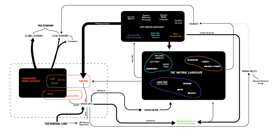
In the case of Eagle Mine, a diverse set of actors continuously manufacture their own narratives of nature and resource values. Through acts of collective storytelling, each group stake claims to overlapping layers of landscape. Although dozens of interests have been involved in the opposition or approval of Eagle Mine, here we will examine the five key players that each have a unique take on the value of the Upper Peninsula landscape.

Print

Actor-Network: The five key actors explored form complex relationships with landscape objects, economies, and mining sites.


“Landscape as Commodity”

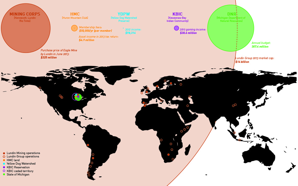
Eagle Mine has changed hands three times in its short history, so the corporations of Kennecott, Rio Tinto, and Lundin are termed here as ‘mining interests.’ The current owner, Lundin Mining Corporation, is Swiss-owned and operates in Europe, Africa, South America, and North America [9]. Lundin Mining is just one branch of the Lundin Group, a $14 billion dollar mineral extraction conglomerate. The title of their 2013 operations map sums up the company’s ethos as a “continuous worldwide quest for overlooked opportunities”.

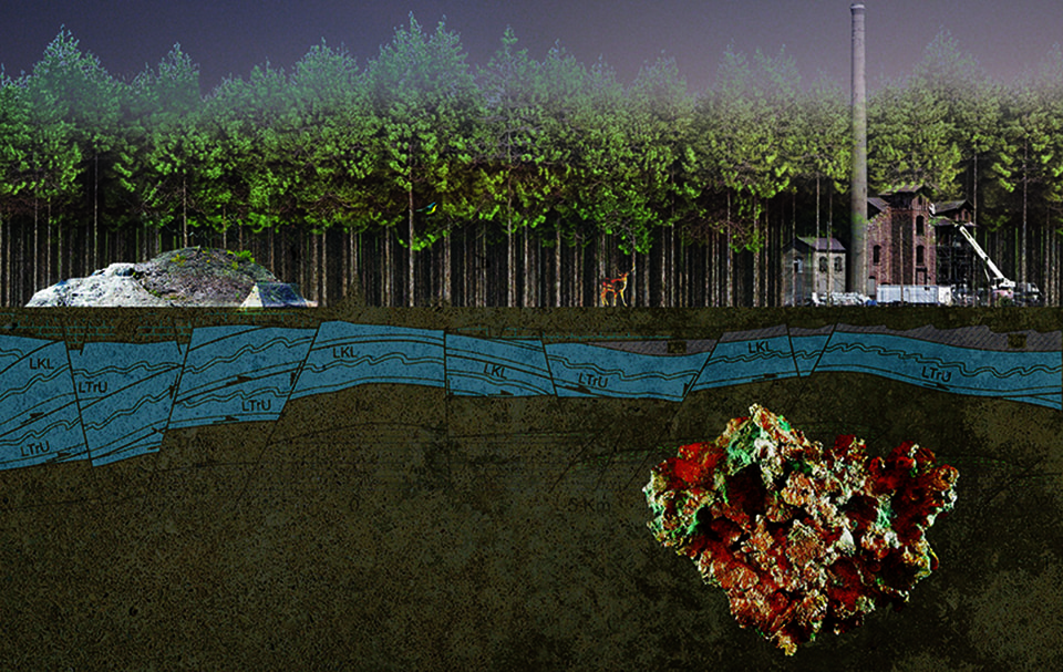
Lundin’s representations of the Eagle Mine project make clear where the value lies for them: in the “high quality and low cost copper” that will be “accretive to Lundin Mining shareholders” [10]. Promotional images highlight the conversion of forested landscape into extraction landscapes and subterranean representations of geological deposits appear as though this commodity is simply floating in empty space, waiting to be harvested [11].

08-Lundin Facilities at Eagle Mine

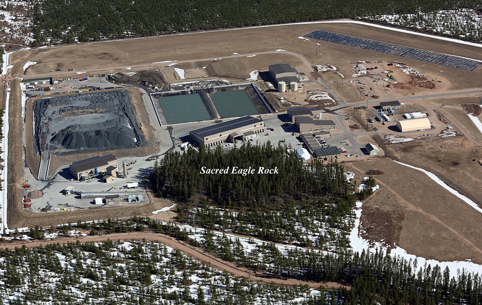
Lundin Facilities at Eagle Mine. (Image courtesy of Jeremiah Eagle Eye)


“Landscape as Heritage”

One of the most powerful voices opposing the legality of Kennecott’s mining permits has been the Keweenaw Bay Indian Community (KBIC), based 15 miles to the west of Eagle Mine, on the largest and oldest Native American reservation in Michigan. Eagle Mine occupies a small part of what used to be expansive Ojibwa Indian territory, spanning Western Upper Michigan and Northern Wisconsin, which was ceded in the Treaty of La Pointe on October 4, 1842. Treaty provisions included fishing and hunting rights, detailing guarantees of special access by tribal members to fish and wildlife within the ceded region [12].

The KBIC tribal council remains attentive to ecological issues within the larger ceded territory through their Natural Resources Department, citing concern for ecosystem damage and toxic drainage into ground and surface water systems. They have “identified mining as a priority concern due to its potential to significantly impact treaty rights, treaty reserved resources, area ecosystems, and the health and welfare of the community and future generations” [13]. Through the heritage of this ceded territory, the KBIC makes claims to the “natural resources” of the Upper Peninsula, for “subsistence, spiritual, cultural, management, and recreational purposes.” For the Keweenaw Bay Indian Community, the narrative is one of heritage, where cultural values are closely tied to the elements of earth, water, plants, and animals.

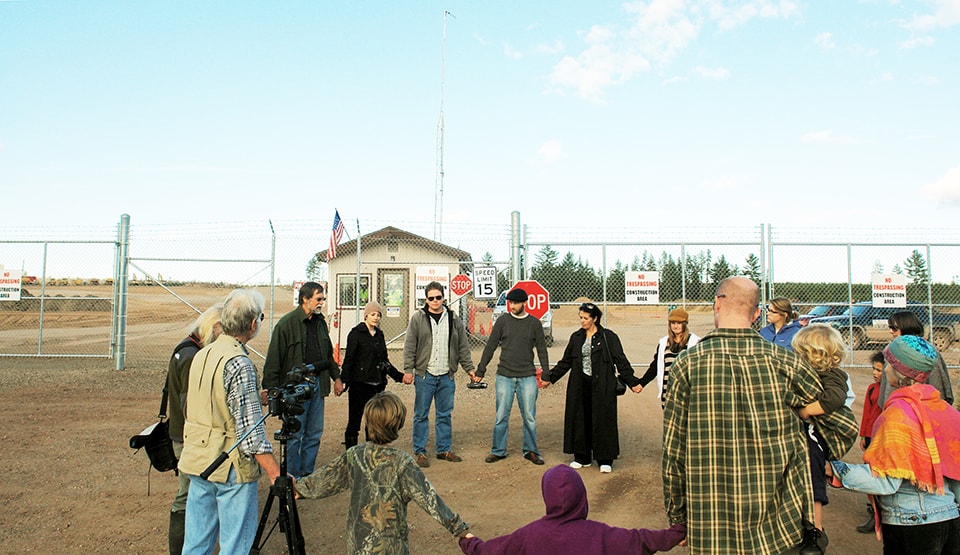
More dramatically, the sulfide lode extends below a rocky forested outcrop called Eagle Rock (Migi Zii Wa Sin), which the KBIC claims as a sacred site, culturally and spiritually important to the Ojibwa. It is a place where vision quests, fasting events, and other ceremonies are still held. The entrance to the Eagle Mine is bored right under Eagle Rock, and fences have been erected around the outcrop. Although Eagle Rock is on public land, the mining interests have attempted to deny access through the terms of their Mineral Lease [14]. Through the leveraging of local police enforcement, claims to the land by the Ojibwe are seemingly superseded by the mining interests’ ability to manipulate power.

These claims ultimately led to a two contested cases and one lawsuit against to the State of Michigan opposing the Eagle Mine beginning in 2007 alongside other local groups. When these cases proved unsuccessful, the KBIC in 2014 petitioned the UN for the State of Michigan’s infractions against the 1842 treaty through their approval of mining operations on traditional Ojibwa territory.

10-Protest at Eagle Mine

Protest at Eagle Mine. (Photo by Yoopernewsman)


“Landscape as Status”

Joining The KBIC in the 2007 contested case against Eagle mine were the The Yellow Dog Watershed Preserve and the Huron Mountain Club (HMC) [15]. The HMC is unique amongst these as an elite, members-only organization.

The Huron Mountain Club is a 26,000 acre private hunting and fishing retreat founded in 1889. It has 150 members most of whom are wealthy families who reside in Chicago or metro Detroit. Access to club land is restricted to members and their guests, and its perimeters are actively patrolled. The HMC and its members are cloaked in secrecy [16]; however, the HMC does allow pre-approved scientific and educational groups to visit their land for academic purposes.

For the exclusive members of the Huron Mountain Club, whose high-end rural retreats share watersheds, air, and fish and game stocks with the Eagle Mine just three miles from their boundary, the ownership of “untouched wilderness” serves as an exclusive mark of status and as a luxury commodity. While in their contested case against Kennecott/Rio Tinto the HMC cites the ecological damage to the rare brook trout spawning habitats in this river, they also cite “irreparable damage to the value of club lands” [17]. For the HMC, landscape value is inherently bound to concerns of wealth and status.

OLYMPUS DIGITAL CAMERA

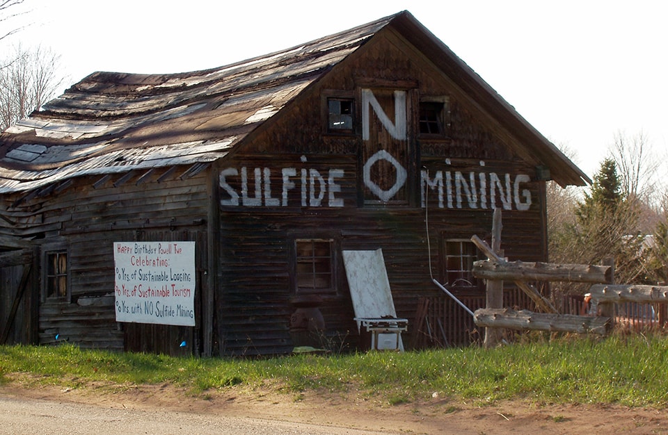
Gene’s Barn, Big Bay, Michigan. (Photo by Save the Wild U.P.)


“Landscape as Ecosystem”

The Yellow Dog Watershed Preserve (YDWP) is an environmental organization and another plaintiff in the contested cases opposing the Eagle Mine. Eagle Mine is sited at the Northern Boundary of the Yellow Dog Watershed in the Yellow Dog Plains, a unique jack pine habitat home to the endangered Kirtland Warbler. The Yellow Dog River “runs free and clean through wild country until it eventually reaches Lake Superior” [18]. Protection of these water supplies and habitats are key to the YDWP’s mission.

Anti-sulfide mining advocacy has grown as one of the YDWP’s focus areas, and besides their political action against the mines through court cases, they also have been monitoring the river’s quality since 2010. One major criticism of copper sulfide mining is the danger of leaching toxic sulfuric acid and heavy metals into groundwater. Through their discussion of water supply, the YDPW’s ecology-centric values are clear: “The most important thing in an ecosystem is the purity of its lifeblood, the water” [19]. In their terms, the landscape is not just a resource to be protected, but a living organism to be cared for and preserved.

BV is 14, AWB Gains: 510, 293, MonoColor: 0, FP: 44, ZPI:418, Curve:5, ZP:3, 01F:302, 05F:81, 15F:44, InfF:29, AFFalling:1, AEAve:1293996, FlaDur:1, SceneMode:0x2

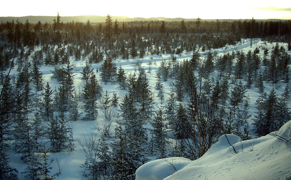
Winter at Eagle Rock, Sacred Ojibwe Site. (Photo by Save the Wild U.P.)


“Landscape as Public Resource”

The actor that actually owns both the surface and mineral rights on the lands leased for the Eagle Mine is the Michigan Department of Natural Resources (DNR). Its stated goals are the “conservation, protection, management, use and enjoyment of the state’s natural and cultural resources for current and future generations” [20]. Their role in the Eagle Mine case suggests that ‘conservation,’ ‘protection’ and ‘enjoyment’ may not so easily align with ‘management’ and ‘use’ in cases where different stakeholders claim different rights to the same piece of land.

The DNR owns 6 million acres of mineral rights, 4.5 million acres of public hunting land, and 2.2 million acres of (leased) farmland [21]. As owners, they walk a difficult line between extracting profit from the land for the benefit of the state, and preserving land for “future generations.” The value of the leased resources themselves can also be called into question relative the value of uncommodified natural landscapes, as a letter to DNR advocating against expansion of Eagle Mine argues:

“this public land is more valuable because its minerals have not been leased, because natural resources on the surface are not undermined or threatened by mine activity. What value does the DNR assign to silence, to the tranquility of being in a wilderness area, to the experience of seeing wild animals and sleeping to the sound of wolves howling at night?…Clearly, Eagle Mine has removed value from public land” [22].

For many opponents of the Eagle Mine, the DNR’s approval of the Kennecott Mineral Lease makes them implicit in crimes against the Upper Michigan landscape. However, their role in the management of natural resources, both above ground (flora, fauna, recreation space, timber, waterways) and below (ore deposits, subsurface water, soils) puts them in a unique position of negotiating between opposing valuations of landscape. The DNR must mediate between the contradictory values of the Upper Peninsula landscape as a tradable resource commodity, as a functioning ecosystem, and as a public natural trust.

Print

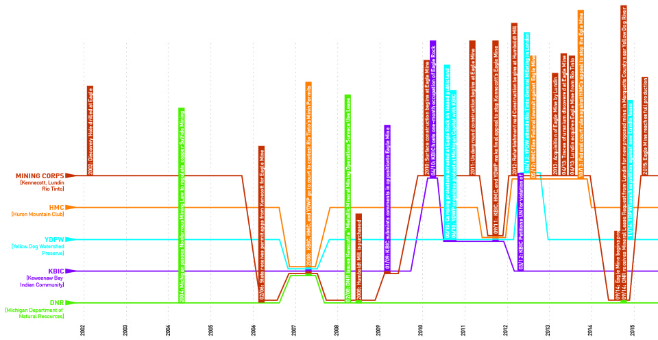
Timelines 2000-2015: The first half of the Eagle Mine saga moved relatively slowly following the discovery of the Eagle Mine lode. However, action and counter-action exploded when the DNR approved the Mineral Lease for the mine.


Verticalizing Territory

Nearly all of these groups make claims to landscape as not only horizontal, but also vertical territory — be it mineral mining/mineral operations, groundwater/surface water, or mineral rights/surface rights. At Eagle Mine, in order to access the economic value of their subterranean commodity, Kennecott first needed to secure the surface via terrestrial claims. In 2008, the Michigan DNR issued a lease for “Mining Operations Surface Use” alongside one for “Metallic Mineral Mining” for the site, thus releasing control of both surface facilities and subsurface materials to the mining interests. Surface control enabled the company to put up fencing around leased public land and to build access roads, as well as to excavate the mine itself and renovate the nearby Humboldt Mill processing facility. And as suggested by environmental groups’ concerns about groundwater uranium and acid leaching, and even atmospheric contamination as mine air is released from below-ground, [23] the impacts of mining operations are not limited to only the surface.

As suggested by the geographer Bruce Braun in his discussion of geologic exploration of Canada, [24] territory becomes verticalized when we begin to value not only the ownership of the surface, but the capital potential of the geological strata which lie beneath it. When this geological strata harbors rich deposits with potential capital gains, as in the case of the Eagle Mine, there is an impetus for verticalizing territory. The above/below-ground dichotomy is especially interesting in relation to the DNR’s surface/mineral ownership split. How can one own what’s below without owning what’s above, or vice versa? Furthermore, what does ownership of specific boundaries mean when fluid systems pass through and beyond them without limitation? The DNR is in a unique position to mediate between competing landscape claims, and perhaps define new metrics of ownership or use within the context of the diverse landscape values discussed here.

15-Yarina-Contested Landscapes

Vertical Territory: Collage showing some of the key objects of value in the sectional landscape: groundwater, wildlife, copper lodes, forest, sacred sites, and recreation spaces.


Conclusion: Re-territorializing landscape

The contested claims to the landscape surrounding Eagle Mine will continue to be tested if the prediction of a second Copper Boom in the Upper Peninsula is correct. The conflict at Eagle Mine shows how value structures lie at the heart of conflicts over landscape and resource use.

As James Proctor discusses in his case study of the dispute over ancient forests, logging rights and spotted owl habitat in the Pacific Northwest, the two (or more) sides of a natural resource conflict often correspond to different ethics of right and wrong [25]. He argues that environmentalists need to recognize the inherent value judgements in their claims for preservation as an inherent good, as opposed to the instrumental productivity of capital-producing activity (such as logging or mining). While compromise between these interests seems unlikely, introducing values into the conversation on environmental issues enables us to recognize the implicit ethics of different stances. These conversations ought to also be tied to discussions of power dynamics and spheres of influence, be they local or transnational. While all of these groups struggle for claims to the same landscape, the leverage behind them is very different.

Print

Scales of Influence: While the landscapes of Marquette county these groups make claims to is the same, the scales of power behind them is far from equal. These visualizations of monetary control and spatial breadth — while not the only metrics for power — demonstrate some of the potential leverage behind the groups studied. Lundin Mining operates on a separate order of magnitude of money and space altogether, relative to local and regional organizations.


By acknowledging the ethics by which they operate, the different groups in the Eagle Mine case can align their scientific claims (water quality, emissions rates, resource quantities) with their political actions (anti-mining advocacy, air quality regulations, mining operations). As Latour suggests in Politics of Nature, [26] letting go of “nature” as a fetishized construct allows us to view objects (in horizontal and vertical territories) and their connection to values and politics as part of a more complex collective. Thus, what each of these groups view as “nature” or “natural resources” become part of a larger conversation about values and priorities through the lens of interconnected systems.

This essay posits that an examination of landscape claims and values should become part of the way that landscape conflict is negotiated. State agencies such as the DNR, which hold the power to grant or deny permits for extraction operations, need to recognize the competing ethics embedded in expressions of value, and to mediate between them in an open and unbiased way. New models of regulation and ownership should aim to move contested landscapes away from binary methods of ownership and use, to systems of use where the production of capital doesn’t preclude ecosystem health, cultural practice, or recreational value.


Elizabeth YarinaElizabeth (Lizzie) Yarina is a joint Masters student in the Department of Architecture and the Department of City Planning at MIT, currently completing her Masters Thesis entitled “POST-ISLAND FUTURES: Design as Agency for Tuvalu’s Sinking Atolls.” Her research explores the role of design thinking in political and territorial issues, with a particular focus on climate change and natural resources. Prior to attending MIT, she worked in the field of Architectural Design at William Rawn Architects in Boston and PLY Architecture in Ann Arbor. She received her Bachelors of Science in Architecture from the University of Michigan in 2010. Lizzie grew up on a sheep farm in Tapiola, Michigan, a 60 mile drive from Eagle Mine along Keweenaw Bay and through Michigamme forest.


Notes

[1] While native copper requires minimal processing, copper sulfide mining produces toxic sulfuric acid when it comes into contact with air and water.
[2] Erik Swyngedouw, “Depoliticized Environments: The end of Nature, Climate Change, and the Post-Political Condition,” Royal Institute of Philosophy Supplement 69 (2011), 253-274.
[3] Bruno Latour, “From Realpolitik to Dingpolitik,” Making Things Public: Atmospheres of Democracy (Cambridge: MIT Press, 2005).
[4] National Park Service, “Timeline of Michigan Copper Mining Prehistory to 1850 – Keweenaw National Historical Park,” http://www.nps.gov/kewe/historyculture/copper-mining-timeline.htm.
[5] Charles E. Cleland, Rites of Conquest: The History and Culture of Michigan’s Native Americans (Ann Arbor: University of Michigan Press, 1992), 18.
[6] William Bryam Gates, “Michigan Copper And Boston Dollars: an economic history oft he Michigan copper mining industry” (Cambridge: Harvard University Press, 1951).
[7] Kurt Hauglie, “Many involved in future of smelter” The Daily Mining Gazette, December 13, 2008, http://www.mininggazette.com/page/content.detail/id/503001.html?nav=5006.
[8] William Cronon, “The Trouble with Wilderness; or, Getting Back to the Wrong Nature” in Uncommon Ground, ed. William Cronon (New York: WW Norton and Company, 1996)
[9] Liezel Hill, “Lundin to Buy U.S. Mine From Rio Tinto for $325 Million,” http://www.bloomberg.com/news/2013-06-12/lundin-to-buy-michigan-mine-from-rio-tinto-for-325-million.html.
[10] Lundin Mining, “Acquisition of Eagle Mine,” Corporate Report. June 13, 2013. http://www.lundinmining.com/i/pdf/2013-06-13_AEMP.pdf
[11] Ibid, 13.
[12] When the contested cases and lawsuit against the State of Michigan ultimately proved unsuccessful, the KBIC in 2014 petitioned the United Nations Special Rapporteur on the Rights of Indigenous Peoples, arguing that in allowing Michigan to approve mining operations on traditional Ojibwa territory, the United States had failed to uphold the 1842 treaty.
[13] Keweenaw Bay Indian Community, “Natural Resources Department,” http://nrd.kbic-nsn.gov.
[14] Cynthia Pryor, “A Sacred Fire Is Burning at Eagle Rock,” HuffPost Green (blog), The Huffington Post, July 7, 2010, http://www.huffingtonpost.com/cynthia-pryor/a-sacred-fire-is-burning_b_567652.html.
[15] Andrew Orthober, “Public Participation in Michigan Mining Policy: the Kennecott Eagle Project Case,” (Masters Thesis, Michigan Technological University, 2012).
[16] Emily Pace, “Behind the Gates,” Upper Michigans Source, May 9, 2008, http://www.uppermichiganssource.com/news/story.aspx?id=132343#.VHjRR0vxhBU.
[17] John Pepin, “Huron Mountain Club loses legal bid to stop Eagle Mine project,” The Mining Journal, October 31, 2013, http://www.miningjournal.net/page/content.detail/id/591991/Huron-Mountain-Club-loses-legal-bid-to-stop-Eagle-Mine-project.html?nav=5006.
[18] “Yellow Dog Watershed Preserve,” accessed October 8, 2015, http://www.yellowdogwatershed.org/home.htm.
[19] Yellow Dog Watershed Preserve, “Water Quality,” accessed October 8, 2015, http://www.yellowdogwatershed.org/blog/water-quality/.
[20] Michigan Department of Natural Resources, “About the DNR,” accessed October 8, 2015, http://www.michigan.gov/dnr/0,4570,7-153-10366—,00.html.
[21] Michigan Department of Natural Resources, “Natural Resources at a Glance,” accessed October 8, 2015, http://www.michigan.gov/dnr/0,4570,7-153-10366-121638–,00.html.
[22] June Rydholm, “Letter to DNR: Deny Eagle Mine’s request for new mineral lease on public land,” Keweenaw Now (blog), November 20, 2014, http://keweenawnow.blogspot.com/2014/11/letter-to-dnr-deny-eagle-mines-request.html.
[23] Save the Wild UP, “Eagle Mine Facts,” http://savethewildup.org/issues/eagle-mine-facts/
[24] Bruce Braun, “Producing Vertical Territory: Geology And Governmentality In Late Victorian Canada,” Cultural Geographies 7, no.1 (2000): 7.
[25] James Proctor, “Whose Nature? The Contested Moral Terrain of Ancient Forests,” in Uncommon Ground: Rethinking the Human Place in Nature, ed. William Cronon (New York: WW Norton and Company, 1996).
[26] Bruno Latour, Politics of nature: how to bring the sciences into democracy, trans. Catherine Porter (Cambridge: Harvard University Press, 2004).

Grounding Water

With water, we often fixate upon the sky and the surface. Conveyed as rain, storm, ocean, rise, river, and flood, water in these horizons is tactile; it can be tasted, felt, and seen. Awash with such abundance and visibility, we have grown complacent in our representation of both the beauty these waters inspire and the threats they impose. There are, however, waters that elude our common senses, particularly those that are below—and dissolved within—the earth. Though they are substantially concealed, these elemental hybrids support vast agricultural and urban landscapes. Groundwater is seen as limitless because it is rarely seen at all.

If groundwater is invisible, representation must become the eyes and imagination of an increasingly myopic surface settlement. But, can an element of landscape as complex as groundwater be seen? Or drawn? What, if any, is the unique ability of the landscape architect in this pursuit? Can it add to that of the geologist? Or engineer? Or poet? Admittedly, many of the contemporary crises surrounding groundwater, in addition to myriad other complicated ecological and urban systems, are the result of failures to steward and conserve our natural environment. However, this article suggests an alternative to characterizations of groundwater as a resource in a state of abundance or depletion. It also challenges conventional landscape representation in the construction of this myth. Ultimately, it is an over-simplification to consider groundwater as an environmental problem that needs to be solved. The more difficult task, and the potential place of the designer, is to represent groundwater as a thing that needs to be seen.

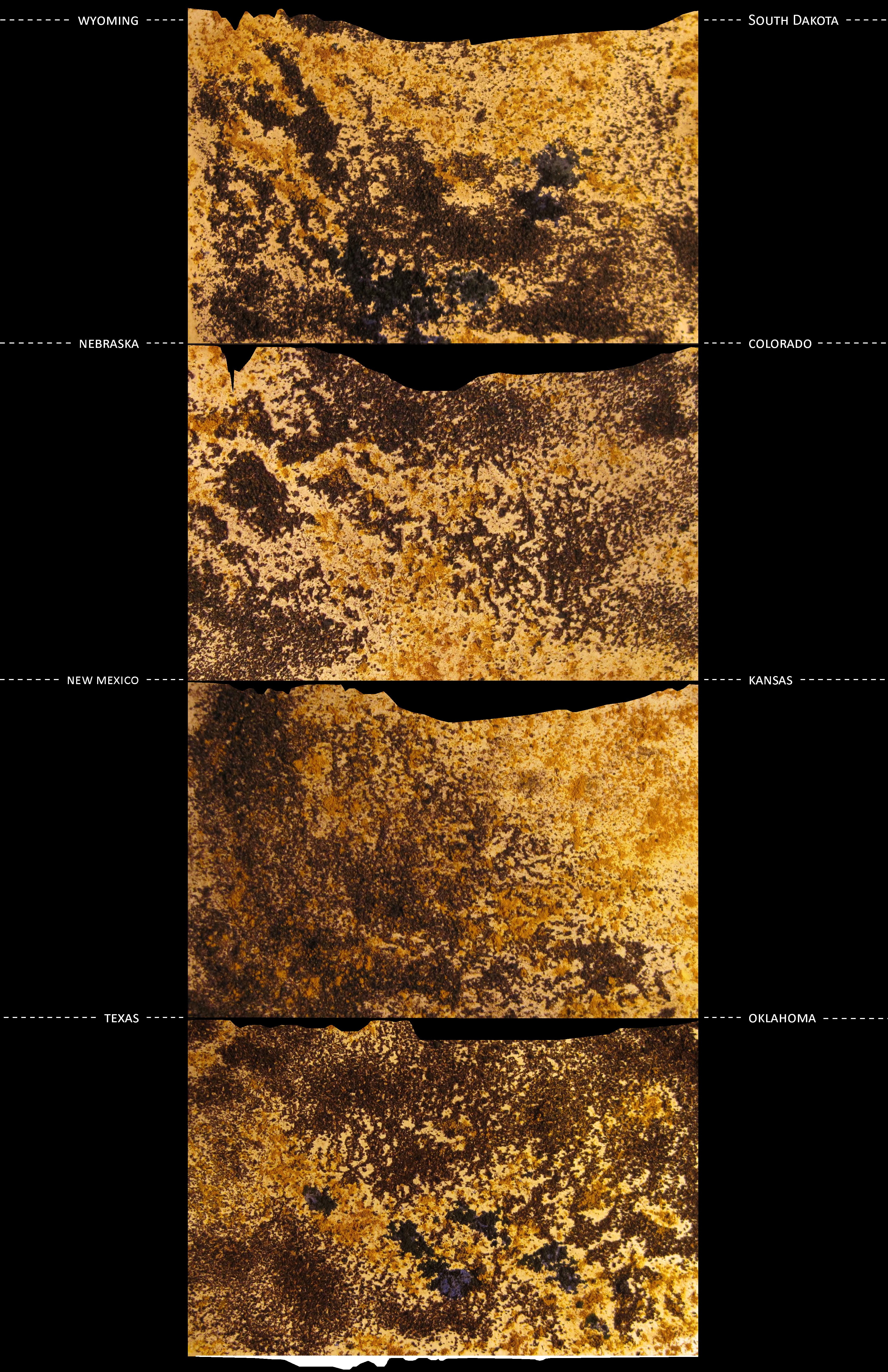
By most standards, the Ogallala Aquifer (also known as the High Plains Aquifer) is shallow – the water table is 33 meters below the surface throughout roughly half the aquifer’s range.[1] Its saturated thickness—a measure of the distance from the top of the water table to the base of the aquifer—ranges from 15 to 365 meters. Even so, the Ogallala is roughly 450,000 square kilometers in size and underlies eight states. It is thought to store one million billion gallons: a volume of water vast enough to cover the entire lower United States by 0.61 meters.[2,3]

“Fossil” waters contained within the Ogallala were charged slowly throughout the Miocene epoch (23.03—5.332 million years ago) during a period when the High Plains was considerably warmer and wetter than it is today. Nascent materials throughout the region absorbed precipitation, atmospheric moisture and the residue of ancestral oceans, and then held it throughout the ages. Today, this stratigraphic layer consists of sands, unconsolidated gravels, and poorly silted clays, which vary considerably in their porosity and hydraulic conductivity. As a geologic unit it is referred to as the Ogallala formation, while locally it is known by pseudonyms including “Ash Hollow,” “Sidney Gravel,” and “Valentine”.[4]

Wiener.Scenario.Grounding.Water

The Ogallala is not a static system, though it is certainly slow. Generally, groundwater flows through the aquifer in an easterly and downslope direction from the Rocky Mountains at a rate of approximately 0.3 m per day.[5] A raindrop that falls in Lake Itasca, at the headwaters of the Mississippi River, could reach the Gulf of Mexico in less than 90 days.[6] A raindrop falling at the northernmost point of the Ogallala in South Dakota (assuming a linear path and a regular rate of laminar flow) might arrive in central Texas after more than 3,500 years.[7] Groundwater’s latency is a result of its microscopic trickle through the interstices of geological formations. In contrast to surface water, which is seen to move rapidly over land in a line, groundwater passes slowly through it as a field.

The Ogallala is described in the science as both unconfined (meaning it is recharged through surface infiltration) and discontinuous. This latter categorization indicates that the aquifer is neither contiguous nor homogenous. Rather, aquitards, non-porous substrates and inhibitory geological features have created a lithic patchwork of deep and shallow pockets where water is enmeshed in ground. In essence, the aquifer is neither consistently wet nor dry. Instead, it is a fluid gradient; wells in the Ogallala may gush over three thousand liters per minute, or increasingly, may yield nothing at all.[8]

In Assembling California, the author and amateur geologist John McPhee writes of two disparate timescales – one human and the other geological. According to McPhee, these temporal axes intersect only occasionally, though the effect is often catastrophic.[9] This junction occurred approximately 70 years ago when human settlement drove a straw into the Ogallala and began to quench its thirst from the water oozing sleepily in the ground.[10] Prior to this catalytic event, Comanche and Sioux tribes practiced a form of nomadism that utilized natural seeps and springs, and eventually relocated when these ran dry.[11] At this time, the High Plains landscape bore the moniker of “Great American Desert.” The region is located within the rain shadow of the Rocky Mountains, and generally exhibits both high rates of evapotranspiration and desiccating winds that wick moisture from its vast and flat landscapes.[12] In certain locations, the aquifer recharges at a rate of less than six millimeters per year.[13] However, upon discovery of the Ogallala and a seemingly limitless water supply, farmers terraformed the country’s most desolate terrain and transformed its economy and global status. By adding water, a bowl of dust became the nation’s granary, “breadbasket,” and “corn belt.”

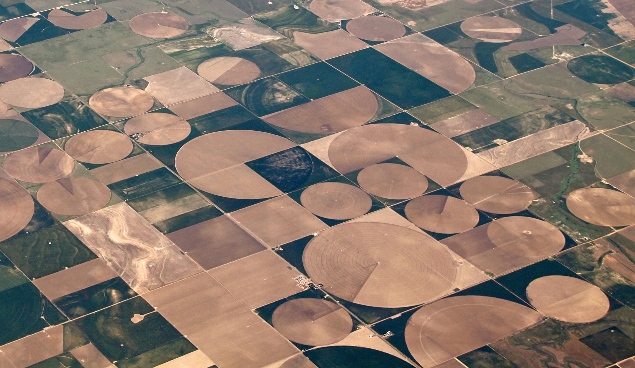
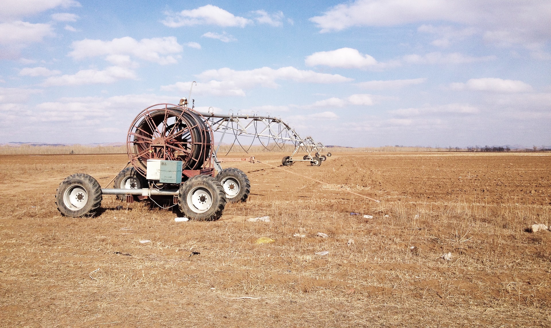
The High Plains trends towards dust; it is verdant only by virtue of human intervention. The rapid transformation of the mid-west, which was as remarkable as it was untenable, was facilitated by the timely confluence of numerous technological innovations in the Great Plains during the 1940s.[14] Frank Zybach’s early center-pivot irrigation system, for instance, utilized boom-mounted water distribution pipes that rotated around a centralized well. This method was ideally suited for the level topography of the High Plains, and the relatively shallow water supply flowing beneath it. Zybach’s system slowly generated the circular crop-geometry ubiquitous today across many Mid-western states.[15] The development of rotary drills with mechanized spinning bits only expedited and increased the efficiency of water mining.[16] As a result, by the 1990s, wells once thought limitless began to run dry, while wells considered marginal were depleted entirely.[17]

Center pivot

Center-pivot irrigation. Image by John Kelly

Today, an estimated seventy percent of the Ogallala remains untapped or available for consumption. By 2110, it will have decreased to thirteen percent.[18] The etymology of the word aquifer quite literally translates to water-bearer or water-bearing. As a result, aquifers in a human timescale are seen ostensibly as a geologic faucet through which water is delivered to the surface.[19] Yet, our Cartesian surface rationality is fundamentally at odds with the subterranean mystery of this aqueous “stuff”.[20] By virtue of its size, heterogeneity, and latency, the Ogallala is less a belowground bathtub than a dynamic geological admixture that muddies the dichotomy between stable earth and liquid morass. Groundwater is an innumerable field of moving rivers entangled intrinsically within earth, not a still pool of water contained by rock. In this way it defies both the linear logic of our relationship with water and the security of our faith in land.

In Geo-Logic, the environmental theorist Robert Frodeman suggests that seeing is more than passive visual data collection. Rather it is an active process of filtration and construction, through which symbols are assigned meaning and a spatially oriented narrative is developed. Seeing, in this operational sense, is a fundamental (perhaps the initial) act of design. However, we must also recognize that sight is an individualized and highly personal experience that is accreted slowly through culture, kinesthesia, and subjective comprehension.[21] Representation is a crucial (and ultimately crude) extension of seeing; it is a both method of conveyance and vehicle of translation.

According to Frodeman, true visual intelligence also requires an envisioning of invisible phenomena through which objects are assembled into systems, cycles, and landscapes in an interrogative dream-like collaboration between the mind and the eye.[22] In this conceptual ground, simply because something isn’t seen, does not mean it isn’t there. To envision groundwater for instance, implies an understanding of its multi-dimensionality and hybridity. It entails a reading and, perhaps more importantly, a willingness to realize the longevity of actions such as contamination and depletion on deep hydrological or geological systems. Representation faces the dual challenge of communicating subjective information, but also of characterizing polyvalent relationships that increasingly and necessarily span temporal and spatial territories.

Certainly, this complexity has been well characterized by landscape architects and theorists including James Corner, Dennis Cosgrove, Anuradha Mathur and Dilip da Cunha, and others who have challenged the Platonic line and reductive notions of Euclidian geometry in landscape representation.[23] In his essay, Liminal Geometry and Elemental Landscape, Cosgrove writes that such geometry was used in an act of construction of cultured landscape or urbanism as separate from the “elemental confusion of water and earth”.[24] However, most representational approaches to groundwater within the discipline and elsewhere remain mired in Euclid’s three foundational elements – points/wells, lines/irrigation networks, and areas/aquifers. There is undeniably a certain security in this tactic, as it allows us to preserve a degree of ambiguity with respect to water’s actual condition. However, this approach imposes a false order upon a fluid milieu for which we lack an imaginative grasp. We see the pipe, not the water it delivers or the resource it diminishes. Such a systematized presentation of the natural world conveys water as an element that is bounded and discrete, not only from ground but also from the settlement that so desperately depends on it.

For landscape architects the tendency to represent natural systems, including groundwater, through conventional modes of architectural drawing is also problematic. According to James Corner, these object-oriented approaches are “precedent to artifice.” They present direct analogies to a physical thing with the expectation that it will eventually modify, and ideally improve, a spatial environment. [25] Unfortunately, landscape architects will never build a “solution” to groundwater, nor will they devise a method for reversing almost a century of wanton extraction. While technological innovations will continue to increase the efficiency of our water use, groundwater is slow to forget, and even slower to recharge.

It would be inappropriate to deny the utility of conventional modes of groundwater mapping and modeling. This is a language understood by many and which carries useful information for a range of political, scientific, and analytical purposes. It would also be inadequate to encourage a form of landscape representation that forgoes its criticality and precision in pursuit of a purely artistic rendering. However, if groundwater is simultaneously complicated geology, finite resource, philosophical mystery, and poetic hubris, a visual sensibility predicated upon a binary that suggests something is present, or isn’t, will no longer suffice. In our seeing and in our drawing we continue to construct artifactual divides between water and ground, science and poetry, and statistic and provocation. To represent groundwater requires a level of envisioning that accepts the frailty of human effort and the impact of monumental unknowns in the frame of geological timescales. This is the challenge that faces the landscape architect in his or her agency as designer, scientist, advocate, and artist. We must envision groundwater because of our dependence upon it, and because it is running out; we must represent groundwater to convey why this is so vitally important.
A version of this article has been published in the University of Pennsylvania’s design journal [Sub]stance.


Wiener.Scenario.headshotMatthew Wiener is currently studying at the New York University School of Law. Previously, he was part of an interdisciplinary research project, titled Structures of Coastal Resilience, and a student in the Master of Landscape Architecture program at the University of Pennsylvania School of Design. Wiener is also the co-editor of a collection of written and visual essays titled Design in the Terrain of Water.


Notes:

[1] James A. Miller and Cynthia L. Appel, Groundwater Atlas of the United States, Kansas, Missouri and Nebraska, U.S. Geological Survey HA 730-D, 1997.
[2] Wil S. Hylton, “Broken Heartland: The Looming Collapse of Agriculture on the Great Plains,” Harper’s Magazine, June 2012.
[3] V. L. Mcguire, Water-level and Storage Changes in the High Plains Aquifer, Predevelopment to 2011 and 2009—11: U.S. Geological Survey Scientific Investigations Report 2012-5291, 2013. http://pubs.usgs.gov/sir/2012/5291/.
[4] Edwin D. Gutengag, Frederick J. Heimes, Noel C. Krothe, Richard R. Luckey, and John B. Weeks. Geohydrology of the High Plains Aquifer in Parts of Colorado, Kansas, Nebraska, New Mexico, Oklahoma, South Dakota, Texas and Wyoming, U.S. Geological Survey Professional Paper 1400-B, 1984
[5] Nebraska, U.S. Geological Survey HA 730-D, 1997.
[6] National Park Service statistics, my own calculation.
[7] My own calculation.
[8] James A. Miller and Cynthia L. Appel, Groundwater Atlas of the United States, Kansas, Missouri and Nebraska, U.S. Geological Survey HA 730-D, 1997.
[9] John McPhee, Assembling California (New York: Farrar, Straus and Giroux, 1993).
[10] Wil S. Hylton, “Broken Heartland: The Looming Collapse of Agriculture on the Great Plains,” Harper’s Magazine, June 2012.
[11] Ibid
[12] Leonard F. Konikow, Groundwater Depletion in the United States (1900-2008): U.S. Geological Survey Scientific Investigations Report 2013-5079. 2013. http://pubs.usgs.gov/sir/2013/5079.
[13] Leonard F. Konikow, Groundwater Depletion in the United States (1900-2008): U.S. Geological Survey Scientific Investigations Report 2013-5079. 2013. http://pubs.usgs.gov/sir/2013/5079.
[14] Wil S. Hylton, “Broken Heartland: The Looming Collapse of Agriculture on the Great Plains,” Harper’s Magazine, June 2012.
[15] James A. Miller and Cynthia L. Appel, Groundwater Atlas of the United States, Kansas, Missouri and Nebraska, U.S. Geological Survey HA 730-D, 1997.
[16] Paul L. Younger, Groundwater in the Environment: An Introduction (Malden, Ma: Blackwell Publishing, 2007).
[17] Wil S. Hylton, “Broken Heartland: The Looming Collapse of Agriculture on the Great Plains,” Harper’s Magazine, June 2012.
[18] David R. Steward, Paul J. Bruss, Xiaoying Yang, Scott A. Staggenborg, Stephen Welch, Michael D. Apley, “Tapping Unsustainable Groundwater Stores for Agricultural Production in the High Plains Aquifer of Kansas, Projects to 2110,” Proceedings of the National Academy of Science 110, no 37. (2013).
[19] Larry L. Mays, Ground and Surface Water Hydrology (Hoboken, New Jersey: John Wiley & Sons, Inc., 2011).
[20] Illich, Ivan. H20 and the Waters of Forgetfulness, Reflections on the Historicity of Stuff (Berkeley, CA: Heyday Books, 1985).
[21] Corner, James. “Representation and landscape: drawing and making in the landscape medium,” Word & Image. Vol. 3. (1992).
[22] Frodeman, Robert. Geo-Logic: Breaking Ground Between Philosophy and the Earth Sciences (Albany: State University of New York Press, 2003).
[23] Dennis Cosgrove, “Liminal geometry and Elemental Landscape: Construction and Representation.” in Recovering Landscape, ed. James Corner (New Jersey: Princeton University Press, 1999) Print.
[24] Dennis Cosgrove, “Liminal geometry and Elemental Landscape: Construction and Representation.” in Recovering Landscape, ed. James Corner (New Jersey: Princeton University Press, 1999) Print.
[25] Corner, James. “Representation and landscape: drawing and making in the landscape medium,” Word & Image Vol. 3, (1992).


A Monument To Mining

“Coal is good for humanity, coal is good for prosperity, coal is an essential part of our economic future, here in Australia, and right around the world.”
– Former Prime Minister Tony Abbott [1]


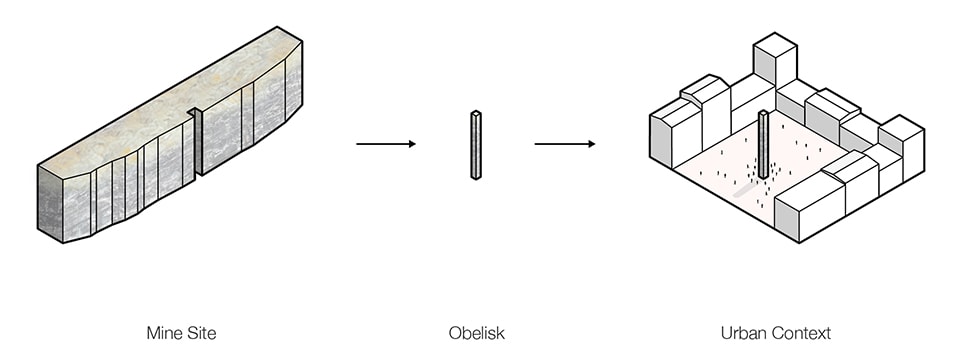
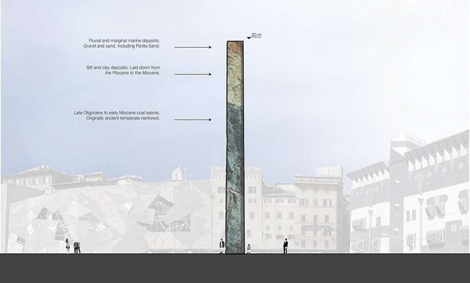
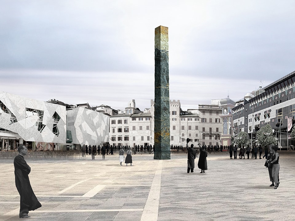
This is a proposal for an urban intervention in Melbourne, Australia: a monument to mining that questions Australia’s relationship with coal and addresses the dualistic spatial relationship between the city and its regional territory.


Context

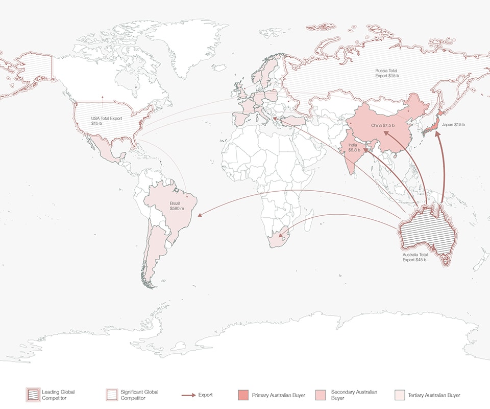
Coal is the primary source of electricity generation globally and continues to grow in dominance [2]. Many countries, both developed and undeveloped, rely almost entirely on coal to power their cities and towns. Australia is the fourth largest producer of coal [3] and is a key distributor to some of the world’s largest economies [4]. The industry accounts for 20% of Australia’s export revenue [5] and generates the vast majority of its major cities’ electricity [6]. This makes Australia thoroughly dependent on coal both economically and for energy consumption, and suggests that a transition to alternative sources of energy in the near future is a great challenge. Paradoxically, Australia is one of the countries most endowed with alternative sources of energy, [7] but its historic and systemic reliance on coal, coupled with a pro-fossil fuel right wing government, will see the Australian economy and its cities inextricably linked to coal mining for the foreseeable future.

WORLD

Australia’s position as leading exporter of coal in the global coal industry.


Invisible territories

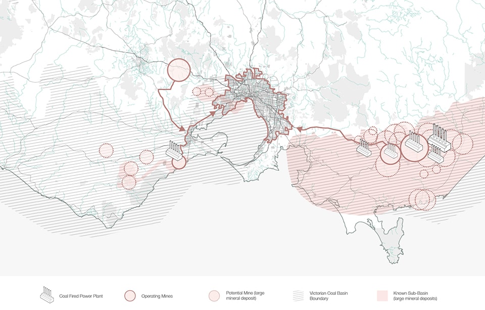
Coal deposits are found throughout the Melbourne metropolitan area, [8] but mining of these deposits is relegated to the city’s regional fringe. The four active mines and power stations are located roughly 100 miles from the city center. Because these mines and power plants are visually unappealing and politically volatile, [9] great efforts are taken to screen and hide these landscapes and their associated infrastructure from public view [10].

Essential to Melbourne’s urban life as these mining landscapes are, shouldn’t they be designed to be more visible? And contentious as they are, shouldn’t they be part of a greater democratic debate? How can citizens engage with these remote mining landscapes in a collective and conscientious manner within the city?

02_Victorian Map_Breedon

Melbourne’s metropolitan area and surrounding regional context. Although the whole region is abundant in coal, most mines and power plants are located in the regional periphery.


Proposal

Melbourne’s dependency on coal, as well as how the city’s growth drives landscape change is not well understood by the general public. It is essential that an understanding of the two-way relationship between the city and its surrounding mining landscapes informs the public debate on coal dependency, energy transition and the future development of Melbourne. Furthermore a common understanding that ‘the city’ does not end at the metropolitan boundary but also encompasses the city’s hinterland may generate new scenarios for a more holistic regional development. This proposal intends to engage citizens in the processes of urbanization and resource extraction in the city’s hinterland.

The proposal suggests that a deep section of Hazelwood mine — the region’s largest — be taken in the form of an obelisk, and placed in Federation Square, one of Melbourne’s most significant public spaces and a regular site for organized protests. A full-size slice of the geology of the entire depth of the mine, at 100ft (30m) high, is to be excavated. The monument would be as tall as the 9-story buildings immediately surrounding Federation Square. The proposal intends to open a dialog between the city and the surrounding mining landscapes by creating an urban condition where people are confronted with the reality of a city powered by coal.

A city’s civic spaces and the monuments they contain are a product of society’s shared, civic beliefs. A city’s monuments may be the result of a struggle between conflicting interest groups, [11] or a socio-spatial manifestation of collective self-representation [12]. Ritual and continual engagement with these urban elements over time develops a shared citizenship and a sustained urban democracy [13]. If these spaces are a reflection of shared citizenship, then symbolic urban elements can act iconographically, eliciting strong emotional responses and perhaps opening up a space for negotiation, opposition and confrontation around local as well as global issues [14].

Collapsing the distance between the city and its coal mining landscapes through the use of a provocative public monument may stimulate public conversation on Melbourne’s coal mining landscapes. The monument may engage citizens in issues beyond their immediate surroundings and foster debate on how Melbourne’s energy needs produce radically altered landscapes. Through public dialog and civic engagement, the city’s citizens may begin to collectively tackle how Melbourne might transition from a singular dependency on coal to new urban energy scenarios.

03_Mining to Urban Context_Breedon

An Obelisk is to be taken from a mining site and placed in Federation Square, one of Melbourne’s most significant urban spaces.

04_Section_Breedon

The Obelisk acts as a deep geological section and didactic tool to understand Melbourne’s mining landscapes.

05_Obelisk_Breedon

The Obelisk in its urban context.


BreedonAlexander Breedon is a landscape architect currently living in Melbourne, Australia. He has worked for internationally recognized landscape architects McGregor Coxall, Australia, and LOLA landscape architects, The Netherlands. He has worked on projects around Europe including the International Architecture Biennale Rotterdam with Project Atelier BrabandtStad. Alex is also a member of 1788, an organization that researches the intersection between Australia’s pre- and post-colonial ecology and consequent landscape interpretation.


Notes

[1] “Coal ‘good for humanity’, Prime Minister Tony Abbott says at $3.9b Queensland mine opening,” ABC News, October 13, 2014, accessed November 15, 2014,
http://www.abc.net.au/news/2014-10-13/coal-is-good-for-humanity-pm-tony-abbott-says/5810244.
[2] “Coal,” International Energy Organization, 2014, accessed December 2, 2014, http://www.iea.org/topics/coal/.
[3] “Australia’s Identified Mineral Resources,” Geoscience Australia, 2012, accessed December 2, 2014, http://www.ga.gov.au/scientific-topics/minerals/mineral-resources/aimr.
[4] “Where did Australia export Coal to in 2012?,” The Harvard Atlas of Economic Complexity, 2012, accessed December 5, 2014, http://atlas.cid.harvard.edu/explore/tree_map/export/aus/show/2701/2012/.
[5] Ibid.
[6] “Generation by fuel type,” RenewEconomy: Tracking the next Industrial Revolution, 2015, accessed December 9, 2014, http://reneweconomy.com.au/nem-watch.
[7] Germany now generates 75% of its energy from solar and is poorly resourced with sunlight in comparison to Australia. Germany’s best irradiation area, in the south of Munich receives <1300 kWh/m2. This is the same as Australia’s worst area for irradiation; southern Tasmania, which receives between 1250-1350 kWh/m2. See: “Global Horizontal Irradiation: Germany,” Geomodel Solar, 2011, accessed December 7, 2014, http://www.mappery.com/map-of/Solar-Radiation-Map-of-Germany; “Global Horizontal Irradiation: Australia,” Geomodel Solar, 2013, accessed December 7, 2014, http://upload.wikimedia.org/wikipedia/commons/c/ce/SolarGIS-Solar-map-Australia-en.png.
[8] Coal deposits are found well within Melbourne’s metro region. See: “Earth Resources: Lignite / Brown coal,” State Government of Victoria: Energy and Earth Resources, 2015, accessed December 5, 2014, http://www.energyandresources.vic.gov.au/earth-resources/victorias-earth-resources/coal.
[9] “Hazelwood expecting more climate change protests,” ABC News, September 13, 2009, accessed December 9, 2014, http://www.abc.net.au/news/2009-09-14/hazelwood-expecting-more-climate-change-protests/1428318.
[10] Extensive screening planting projects have been planned around the perimeter of the Hazelwood mine. See Figure 3.13 in:
“Fire prevention and mitigation measures adopted at the Hazelwood mine,” Hazelwood Mine Fire Enquiry, 2014, accessed December 9, 2014, http://report.hazelwoodinquiry.vic.gov.au/part-three-fire-risk-management/fire-prevention-mitigation-measures-taken-gdf-suez/fire-prevention-mitigation-measures-adopted-hazelwood-mine.
[11] Yvonne Whelan, “The construction and destruction of a colonial landscape: monuments to British monarchs in Dublin before and after independence,” Journal of Historical Geography 28, no. 4 (2002): 508-533.
[12] Tali Hatuka and Rachel Kallus, “The Architecture of Repeated Rituals,” Journal of Architectural Education 61, no. 4 (2008): 85-94.
[13] Richard Sennett, The Spaces of Democracy (Ann Arbor: University of Michigan Press, 1998), 41.
[14] J. Wesley Judd, “The role of public spaces after tragedy,” Pacific Standard, January 9, 2015, accessed October 21, 2015, http://www.psmag.com/politics-and-law/role-public-spaces-tragedy-charlie-hebdo-paris-france-97942.

Header image by Bert Kaufmann