With water, we often fixate upon the sky and the surface. Conveyed as rain, storm, ocean, rise, river, and flood, water in these horizons is tactile; it can be tasted, felt, and seen. Awash with such abundance and visibility, we have grown complacent in our representation of both the beauty these waters inspire and the threats they impose. There are, however, waters that elude our common senses, particularly those that are below—and dissolved within—the earth. Though they are substantially concealed, these elemental hybrids support vast agricultural and urban landscapes. Groundwater is seen as limitless because it is rarely seen at all.
If groundwater is invisible, representation must become the eyes and imagination of an increasingly myopic surface settlement. But, can an element of landscape as complex as groundwater be seen? Or drawn? What, if any, is the unique ability of the landscape architect in this pursuit? Can it add to that of the geologist? Or engineer? Or poet? Admittedly, many of the contemporary crises surrounding groundwater, in addition to myriad other complicated ecological and urban systems, are the result of failures to steward and conserve our natural environment. However, this article suggests an alternative to characterizations of groundwater as a resource in a state of abundance or depletion. It also challenges conventional landscape representation in the construction of this myth. Ultimately, it is an over-simplification to consider groundwater as an environmental problem that needs to be solved. The more difficult task, and the potential place of the designer, is to represent groundwater as a thing that needs to be seen.
By most standards, the Ogallala Aquifer (also known as the High Plains Aquifer) is shallow – the water table is 33 meters below the surface throughout roughly half the aquifer’s range.[1] Its saturated thickness—a measure of the distance from the top of the water table to the base of the aquifer—ranges from 15 to 365 meters. Even so, the Ogallala is roughly 450,000 square kilometers in size and underlies eight states. It is thought to store one million billion gallons: a volume of water vast enough to cover the entire lower United States by 0.61 meters.[2,3]
“Fossil” waters contained within the Ogallala were charged slowly throughout the Miocene epoch (23.03—5.332 million years ago) during a period when the High Plains was considerably warmer and wetter than it is today. Nascent materials throughout the region absorbed precipitation, atmospheric moisture and the residue of ancestral oceans, and then held it throughout the ages. Today, this stratigraphic layer consists of sands, unconsolidated gravels, and poorly silted clays, which vary considerably in their porosity and hydraulic conductivity. As a geologic unit it is referred to as the Ogallala formation, while locally it is known by pseudonyms including “Ash Hollow,” “Sidney Gravel,” and “Valentine”.[4]
The Ogallala is not a static system, though it is certainly slow. Generally, groundwater flows through the aquifer in an easterly and downslope direction from the Rocky Mountains at a rate of approximately 0.3 m per day.[5] A raindrop that falls in Lake Itasca, at the headwaters of the Mississippi River, could reach the Gulf of Mexico in less than 90 days.[6] A raindrop falling at the northernmost point of the Ogallala in South Dakota (assuming a linear path and a regular rate of laminar flow) might arrive in central Texas after more than 3,500 years.[7] Groundwater’s latency is a result of its microscopic trickle through the interstices of geological formations. In contrast to surface water, which is seen to move rapidly over land in a line, groundwater passes slowly through it as a field.
The Ogallala is described in the science as both unconfined (meaning it is recharged through surface infiltration) and discontinuous. This latter categorization indicates that the aquifer is neither contiguous nor homogenous. Rather, aquitards, non-porous substrates and inhibitory geological features have created a lithic patchwork of deep and shallow pockets where water is enmeshed in ground. In essence, the aquifer is neither consistently wet nor dry. Instead, it is a fluid gradient; wells in the Ogallala may gush over three thousand liters per minute, or increasingly, may yield nothing at all.[8]
In Assembling California, the author and amateur geologist John McPhee writes of two disparate timescales – one human and the other geological. According to McPhee, these temporal axes intersect only occasionally, though the effect is often catastrophic.[9] This junction occurred approximately 70 years ago when human settlement drove a straw into the Ogallala and began to quench its thirst from the water oozing sleepily in the ground.[10] Prior to this catalytic event, Comanche and Sioux tribes practiced a form of nomadism that utilized natural seeps and springs, and eventually relocated when these ran dry.[11] At this time, the High Plains landscape bore the moniker of “Great American Desert.” The region is located within the rain shadow of the Rocky Mountains, and generally exhibits both high rates of evapotranspiration and desiccating winds that wick moisture from its vast and flat landscapes.[12] In certain locations, the aquifer recharges at a rate of less than six millimeters per year.[13] However, upon discovery of the Ogallala and a seemingly limitless water supply, farmers terraformed the country’s most desolate terrain and transformed its economy and global status. By adding water, a bowl of dust became the nation’s granary, “breadbasket,” and “corn belt.”
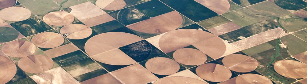
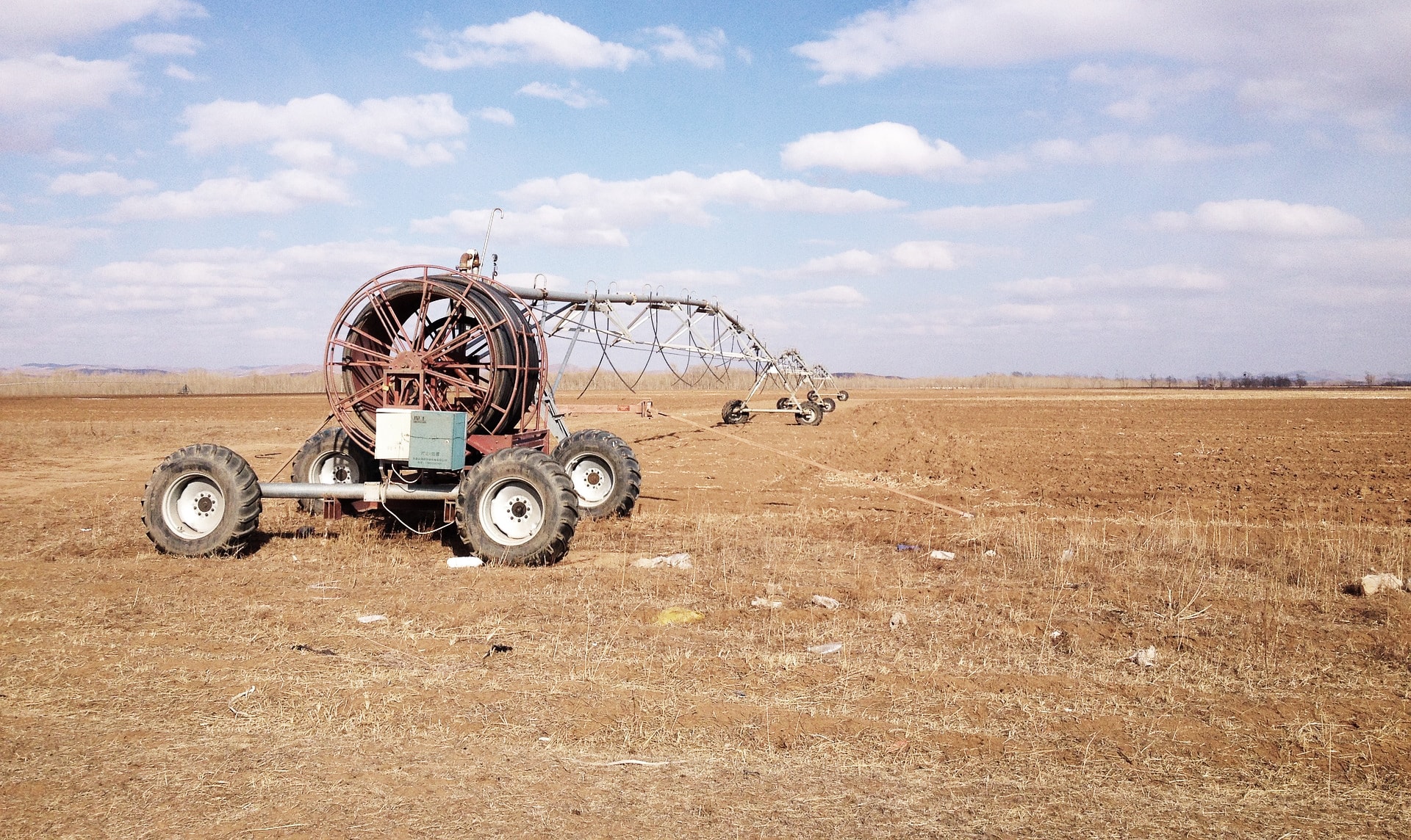
The High Plains trends towards dust; it is verdant only by virtue of human intervention. The rapid transformation of the mid-west, which was as remarkable as it was untenable, was facilitated by the timely confluence of numerous technological innovations in the Great Plains during the 1940s.[14] Frank Zybach’s early center-pivot irrigation system, for instance, utilized boom-mounted water distribution pipes that rotated around a centralized well. This method was ideally suited for the level topography of the High Plains, and the relatively shallow water supply flowing beneath it. Zybach’s system slowly generated the circular crop-geometry ubiquitous today across many Mid-western states.[15] The development of rotary drills with mechanized spinning bits only expedited and increased the efficiency of water mining.[16] As a result, by the 1990s, wells once thought limitless began to run dry, while wells considered marginal were depleted entirely.[17]
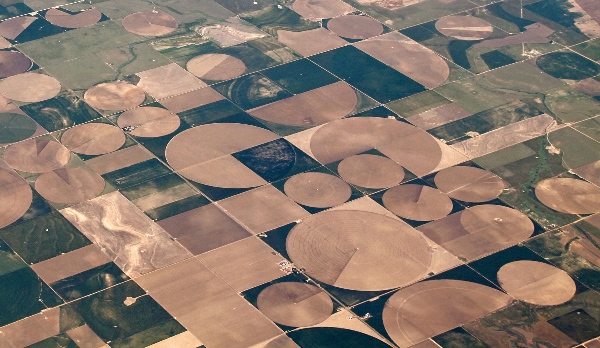
Center-pivot irrigation. Image by John Kelly
Today, an estimated seventy percent of the Ogallala remains untapped or available for consumption. By 2110, it will have decreased to thirteen percent.[18] The etymology of the word aquifer quite literally translates to water-bearer or water-bearing. As a result, aquifers in a human timescale are seen ostensibly as a geologic faucet through which water is delivered to the surface.[19] Yet, our Cartesian surface rationality is fundamentally at odds with the subterranean mystery of this aqueous “stuff”.[20] By virtue of its size, heterogeneity, and latency, the Ogallala is less a belowground bathtub than a dynamic geological admixture that muddies the dichotomy between stable earth and liquid morass. Groundwater is an innumerable field of moving rivers entangled intrinsically within earth, not a still pool of water contained by rock. In this way it defies both the linear logic of our relationship with water and the security of our faith in land.
In Geo-Logic, the environmental theorist Robert Frodeman suggests that seeing is more than passive visual data collection. Rather it is an active process of filtration and construction, through which symbols are assigned meaning and a spatially oriented narrative is developed. Seeing, in this operational sense, is a fundamental (perhaps the initial) act of design. However, we must also recognize that sight is an individualized and highly personal experience that is accreted slowly through culture, kinesthesia, and subjective comprehension.[21] Representation is a crucial (and ultimately crude) extension of seeing; it is a both method of conveyance and vehicle of translation.
According to Frodeman, true visual intelligence also requires an envisioning of invisible phenomena through which objects are assembled into systems, cycles, and landscapes in an interrogative dream-like collaboration between the mind and the eye.[22] In this conceptual ground, simply because something isn’t seen, does not mean it isn’t there. To envision groundwater for instance, implies an understanding of its multi-dimensionality and hybridity. It entails a reading and, perhaps more importantly, a willingness to realize the longevity of actions such as contamination and depletion on deep hydrological or geological systems. Representation faces the dual challenge of communicating subjective information, but also of characterizing polyvalent relationships that increasingly and necessarily span temporal and spatial territories.
Certainly, this complexity has been well characterized by landscape architects and theorists including James Corner, Dennis Cosgrove, Anuradha Mathur and Dilip da Cunha, and others who have challenged the Platonic line and reductive notions of Euclidian geometry in landscape representation.[23] In his essay, Liminal Geometry and Elemental Landscape, Cosgrove writes that such geometry was used in an act of construction of cultured landscape or urbanism as separate from the “elemental confusion of water and earth”.[24] However, most representational approaches to groundwater within the discipline and elsewhere remain mired in Euclid’s three foundational elements – points/wells, lines/irrigation networks, and areas/aquifers. There is undeniably a certain security in this tactic, as it allows us to preserve a degree of ambiguity with respect to water’s actual condition. However, this approach imposes a false order upon a fluid milieu for which we lack an imaginative grasp. We see the pipe, not the water it delivers or the resource it diminishes. Such a systematized presentation of the natural world conveys water as an element that is bounded and discrete, not only from ground but also from the settlement that so desperately depends on it.
For landscape architects the tendency to represent natural systems, including groundwater, through conventional modes of architectural drawing is also problematic. According to James Corner, these object-oriented approaches are “precedent to artifice.” They present direct analogies to a physical thing with the expectation that it will eventually modify, and ideally improve, a spatial environment. [25] Unfortunately, landscape architects will never build a “solution” to groundwater, nor will they devise a method for reversing almost a century of wanton extraction. While technological innovations will continue to increase the efficiency of our water use, groundwater is slow to forget, and even slower to recharge.
It would be inappropriate to deny the utility of conventional modes of groundwater mapping and modeling. This is a language understood by many and which carries useful information for a range of political, scientific, and analytical purposes. It would also be inadequate to encourage a form of landscape representation that forgoes its criticality and precision in pursuit of a purely artistic rendering. However, if groundwater is simultaneously complicated geology, finite resource, philosophical mystery, and poetic hubris, a visual sensibility predicated upon a binary that suggests something is present, or isn’t, will no longer suffice. In our seeing and in our drawing we continue to construct artifactual divides between water and ground, science and poetry, and statistic and provocation. To represent groundwater requires a level of envisioning that accepts the frailty of human effort and the impact of monumental unknowns in the frame of geological timescales. This is the challenge that faces the landscape architect in his or her agency as designer, scientist, advocate, and artist. We must envision groundwater because of our dependence upon it, and because it is running out; we must represent groundwater to convey why this is so vitally important.
A version of this article has been published in the University of Pennsylvania’s design journal [Sub]stance.
 Matthew Wiener is currently studying at the New York University School of Law. Previously, he was part of an interdisciplinary research project, titled Structures of Coastal Resilience, and a student in the Master of Landscape Architecture program at the University of Pennsylvania School of Design. Wiener is also the co-editor of a collection of written and visual essays titled Design in the Terrain of Water.
Notes:
[1] James A. Miller and Cynthia L. Appel, Groundwater Atlas of the United States, Kansas, Missouri and Nebraska, U.S. Geological Survey HA 730-D, 1997.
[2] Wil S. Hylton, “Broken Heartland: The Looming Collapse of Agriculture on the Great Plains,” Harper’s Magazine, June 2012.
[3] V. L. Mcguire, Water-level and Storage Changes in the High Plains Aquifer, Predevelopment to 2011 and 2009—11: U.S. Geological Survey Scientific Investigations Report 2012-5291, 2013. http://pubs.usgs.gov/sir/2012/5291/.
[4] Edwin D. Gutengag, Frederick J. Heimes, Noel C. Krothe, Richard R. Luckey, and John B. Weeks. Geohydrology of the High Plains Aquifer in Parts of Colorado, Kansas, Nebraska, New Mexico, Oklahoma, South Dakota, Texas and Wyoming, U.S. Geological Survey Professional Paper 1400-B, 1984
[5] Nebraska, U.S. Geological Survey HA 730-D, 1997.
[6] National Park Service statistics, my own calculation.
[7] My own calculation.
[8] James A. Miller and Cynthia L. Appel, Groundwater Atlas of the United States, Kansas, Missouri and Nebraska, U.S. Geological Survey HA 730-D, 1997.
[9] John McPhee, Assembling California (New York: Farrar, Straus and Giroux, 1993).
[10] Wil S. Hylton, “Broken Heartland: The Looming Collapse of Agriculture on the Great Plains,” Harper’s Magazine, June 2012.
[11] Ibid
[12] Leonard F. Konikow, Groundwater Depletion in the United States (1900-2008): U.S. Geological Survey Scientific Investigations Report 2013-5079. 2013. http://pubs.usgs.gov/sir/2013/5079.
[13] Leonard F. Konikow, Groundwater Depletion in the United States (1900-2008): U.S. Geological Survey Scientific Investigations Report 2013-5079. 2013. http://pubs.usgs.gov/sir/2013/5079.
[14] Wil S. Hylton, “Broken Heartland: The Looming Collapse of Agriculture on the Great Plains,” Harper’s Magazine, June 2012.
[15] James A. Miller and Cynthia L. Appel, Groundwater Atlas of the United States, Kansas, Missouri and Nebraska, U.S. Geological Survey HA 730-D, 1997.
[16] Paul L. Younger, Groundwater in the Environment: An Introduction (Malden, Ma: Blackwell Publishing, 2007).
[17] Wil S. Hylton, “Broken Heartland: The Looming Collapse of Agriculture on the Great Plains,” Harper’s Magazine, June 2012.
[18] David R. Steward, Paul J. Bruss, Xiaoying Yang, Scott A. Staggenborg, Stephen Welch, Michael D. Apley, “Tapping Unsustainable Groundwater Stores for Agricultural Production in the High Plains Aquifer of Kansas, Projects to 2110,” Proceedings of the National Academy of Science 110, no 37. (2013).
[19] Larry L. Mays, Ground and Surface Water Hydrology (Hoboken, New Jersey: John Wiley & Sons, Inc., 2011).
[20] Illich, Ivan. H20 and the Waters of Forgetfulness, Reflections on the Historicity of Stuff (Berkeley, CA: Heyday Books, 1985).
[21] Corner, James. “Representation and landscape: drawing and making in the landscape medium,” Word & Image. Vol. 3. (1992).
[22] Frodeman, Robert. Geo-Logic: Breaking Ground Between Philosophy and the Earth Sciences (Albany: State University of New York Press, 2003).
[23] Dennis Cosgrove, “Liminal geometry and Elemental Landscape: Construction and Representation.” in Recovering Landscape, ed. James Corner (New Jersey: Princeton University Press, 1999) Print.
[24] Dennis Cosgrove, “Liminal geometry and Elemental Landscape: Construction and Representation.” in Recovering Landscape, ed. James Corner (New Jersey: Princeton University Press, 1999) Print.
[25] Corner, James. “Representation and landscape: drawing and making in the landscape medium,” Word & Image Vol. 3, (1992).