Energy infrastructure, long the purview of engineers, regulators, market analysts, and utilities, is facing a systemic realignment. The United States, like other major industrialized economies, has recently committed to supporting a massive expansion of renewable energy as a way to meet its international carbon reduction goals [1]. Although the mineral energy regime will continue to dominate the grid for a long time to come, major pools of solar and wind energy are being developed on vast stretches of landscape all across the American West [2]. The recent drought along the West Coast has only amplified the risk to traditional energy sources, as operators at some coal and nuclear plants have scrambled to retrofit their cooling water intakes to accommodate the dropping reservoir levels [3]. Both regulatory and economic trends point to the fact that slowly but surely, the U.S. will decarbonize; this energy transition will rest on a massive expansion of big new renewable sources of energy.
Energy production consumes not only the natural resources extracted from the earth to produce power — it consumes territory itself. For instance, removing coal from the earth fundamentally changes the landscape above the seam, and replaces it with a new, indelibly transformed, above-ground landscape. Fields of oil drilling rigs fragment the territory with roads, fences, and foundation pads. Renewable energy, while less disruptive than traditional coal mining or oil production, nonetheless has localized environmental impacts: expansive solar arrays and wind farms denude vegetation for their foundation pads and cut up the landscape with myriad access roads and wires. Large-scale energy production doesn’t just extract the raw materials for making electricity, but alters all aspects of the landscape.
While aesthetics and perceptions vary, the technological objects themselves are marvels of engineering: solar arrays and wind farms, in their scale, speak to the technological sublime [4]. But with the areas of the nation’s most concentrated solar and wind potential overlapping closely with beloved natural areas, heroic infrastructure will inevitably come into conflict with majestic wild landscapes and rural vistas all across the Western U.S. [5]. Alongside the localized impact by renewables will be the inevitable territorial transformation of entire regions, as massive new solar plants and wind farms come online, new corridors of transmission take shape, new industries are catalyzed, and associated infrastructures follow. The broader renewable energy transition will affect virtually all aspects of energy production, transmission, and storage, and impact vast tracts of federally-owned public land. It is a change on the scale of the great public works projects of the 1920s and ‘30s, such as the Tennessee Valley Authority [6] — but where is our visionary regional planner, our Benton MacKaye, to offer a roadmap to the civic potential of these vast new energy landscapes?
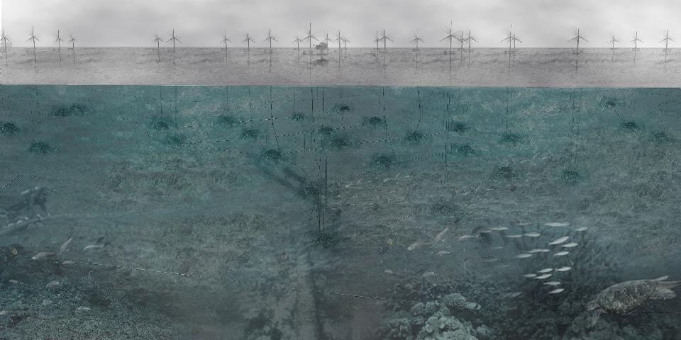
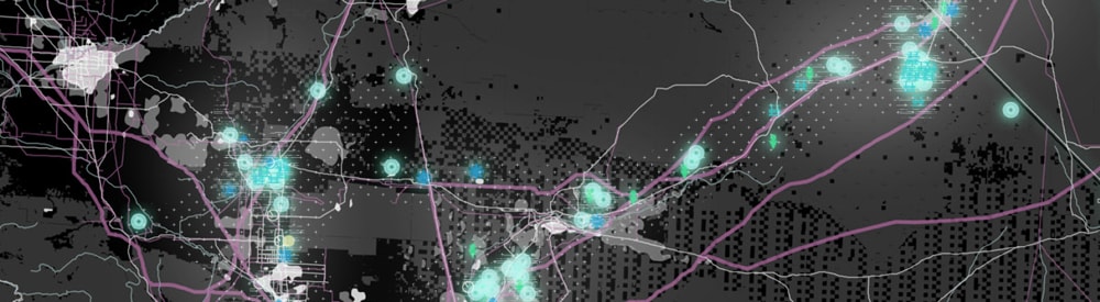
Multipurpose spine of offshore wind farming, energy transmission,
fisheries protection, onshore manufacturing, and offshore ecotourism.
UPenn Studio, “Territories of Extraction,” Spring 2014.
Student work “Pacific Connection” by Min Kwon.
Transforming the U.S. energy system is a monumental task that is both daunting and inspiring. For this transition to be successful, energy policy cannot rely only on new technology, engineering, and arguments of efficiency — it needs to accommodate economics, social considerations, and land management. The physical impacts of new infrastructure are important to consider at the site scale, but also in the context of larger landscape systems and interconnected flows of raw materials, water, capital, jobs, associated industries, natural habitats, and settlement. This moment of energy transition presents an opportunity to rethink routes of energy infrastructure as backbones of a synergistic and multifunctional network, with the potential to balance new public uses with new habitats, ecological restoration with economic development.
This piece draws from research conducted during a landscape architecture studio, “Territories of Extraction,” taught by the author at the University of Pennsylvania in Spring 2014, which explored these themes and topics in relation to the American West, looking for speculative design approaches and planning strategies that can take advantage of the energy transition, and visualizing the ways in which these changes will affect both places and people.
Energy and Public Lands
To achieve its ambitious goals for the energy transition, the U.S. federal government is relying heavily on its federal lands. The government holds vast swaths of public land in the American West, with the majority of these lands controlled by the Bureau of Land Management (BLM) and the U.S. Forest Service (USFS), (contained within the Department of the Interior and the Department of Agriculture, respectively). On private land, the government is limited to blunt tools like subsidies and regulation for either spurring renewable energy development or limiting pollution. But it can be much more precise and aggressive on public land, by directly approving or denying permits to utilities and companies, and by fast-tracking the approvals process.
Early in the Obama administration’s first term, Secretary of the Interior Ken Salazar established the development of renewable energy on public land as one of the highest priorities for the Department of the Interior [7]. Subsequently, the government has been using its authority to encourage and streamline solar and wind installations on land it owns, with the goal of permitting 20 gigawatts of renewable energy on public lands by 2020 [8]. BLM has identified over 19 million acres as having excellent solar potential, and over 20 million acres with wind potential. BLM currently has 23 wind energy development applications pending for over 275,000 acres and 70 solar energy projects pending, for 560,000 acres [9].
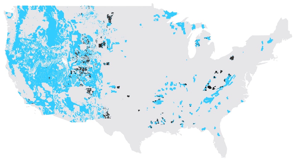
The federal government controls over 700 million acres of public land in the American West. This map shows all U.S. public lands managed under the Multiple Use Mandate (blue), with currently active coal mines, oil wells, and gas wells on public land (black). Data Source: U.S. Energy Information Administration (EIA)
Energy development on public lands is contentious as public lands are intended to serve multiple uses, and extraction is a use that excludes all others. The Multiple Use Mandate, which forms the core of BLM’s mission, asks federal agencies to balance “the quality of scientific, scenic, historical, ecological, environmental, air and atmospheric, water resource, and archeological values” on public lands, while also preserving habitat for fish and wildlife, and providing for outdoor recreation, human occupancy, and use [10]. The US Forest Service similarly follows the principles of Multiple Use and Sustained Yield in managing their own public land holdings [11]. The Multiple Use Mandate asks these agencies to balance extraction versus watershed protection, outdoor recreation, wilderness and habitat protection. It demands that land managers critically evaluate and accommodate competing, and sometimes complimentary, uses and users on public land.
While many environmentalists and outdoorsmen perceive energy extraction on public land — even for renewables — as an affront to their unspoiled public wilderness, the history of public lands is inextricably tied to energy extraction. Some of the first public lands in the West were fuel lands.
At the close of the 19th century, as the U.S. was actively enticing settlers and ranchers to move to the newly opened federal territory west of the Mississippi River with laws such as the Homestead Act of 1862 and the Enlarged Homestead Act of 1909, the US Geological Survey was tasked with racing ahead of the settlers and speculators in order to survey, delineate, and set aside valuable tracts of land that should be retained in public ownership. The USGS initially looked for lands with timber resources, mineral and coal deposits, and prime areas for generating water power (Hays). President Teddy Roosevelt, addressing Congress in 1907, called for legislation to set aside such fuel lands as public domain as quickly as possible:
“from henceforth the nation should retain its title to its fuel resources, and its right to supervise their development in the interest of the public as a whole… Mineral fuels, like the forests and navigable steams, should be treated as pubic utilities….Let us not do what the next generation cannot undo. We have a right to a proper use of both the forests and the fuel during our lifetime but we should not dispose of the birthright of our children. If this government sells its remaining fuel lands, they pass out of its future control.” [12]
Many of the public lands that are cherished today for their recreation or wilderness value, thus owe their existence to their perceived resource potential at the turn of the last century.
Although water power and coal were the two largest historic forms of energy extraction on public land, natural gas has caught up and overtaken hydroelectricity in recent decades. Coal still counts for the vast majority of all the energy produced on public land, supplying over 65% of the total, while both solar and wind power account for less than 1% of the total [13]. Today, almost half of all unexploited fossil fuel reserves in the U.S. are found under public lands and waters; for the last two decades these lands have been the source of between 22% and 26% of the nation’s yearly carbon emissions [14]. Energy extraction industries continue to benefit from the extensive contiguity of public lands, which allows them to operate across large territories at economies of scale. Because of the nature of energy production, utilities traditionally prefer to operate centralized, large-scale installations, and extract as much as possible from a single lease.
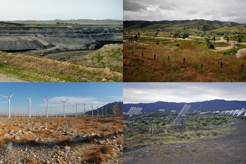
Energy extraction on public land: Coal mining, Oil drilling, Solar Farming, and Wind Farming. Photos (Clockwise from Top Left): WildEarth Guardians, Ryan Stavely, Gregg M. Erickson, Pacific Southwest Region USFWS.
The recent push to accelerate renewable energy development on public land follows from a long history of leasing the federal estate for energy production; today, however, the value and the use of these lands has shifted. Targets such as 35% renewable electricity have been proposed [15] for public lands, but such dramatic expansions of new extraction operations would by definition displace some of the other uses and users. Compared to coal and oil extraction, the impact of renewables on the landscape are certainly less extreme, but still significant: compared to coal, the newer technologies of solar and wind have decreased both the relative consumption of the landscape per kilowatt, [16] as well as the water-intensiveness of electricity generation. However, because of new ideas about how land ought to be managed, with public access and habitat concerns now competing with the pure raising of profits and the disbursement of leases for “productive” use, the federal agencies abiding by the Multiple Use Mandate now have a finer balancing act to perform.
While government has little control over extraction on private lands, it has both an opportunity and an obligation to manage public extraction landscapes in perpetuity, in line with both the Multiple Use Mandate and with Gifford Pinchot’s edict to use public lands to offer “the greatest good for the greatest number, in the long run” [17]. The restrictions and motivations of the Multiple-Use Mandate mean that land managers need to think of extraction on public lands in a larger context, and plan more actively for the network of transformed landscapes that result from the sum total of many separate leases granted across the federal estate. They need to manage these lands in perpetuity, which means actively planning for the legacies of extraction, [18] and ensuring that the second lives of extracted landscapes are not merely degraded versions of their pre-extraction selves.
They need to look for opportunities for synergy, which means taking advantage of infrastructures built by private actors for extraction operations, which can be co-opted for public ends. Through regulation, federal land managers can compel energy operators to act in ways that will further a pubic agenda. But first, to ensure that the expansion of renewable energy across the West is embraced by the many users that share these public lands, what is needed today is a larger vision of public works for these new extraction landscapes.
Landscapes of Intensification
A look at previous energy transitions suggests that a new energy technology doesn’t just enter mainstream use on its own—for a new energy regime to take root, it typically needs to be supported by a “landscape of intensification” that provide the ground for a new market and technology. Energy historian Christopher Jones describes “landscapes of intensification” as the construction of infrastructural linkages from remote places of production to urban centers of consumptions, plus the social support and economic backing that enables the financing and construction of these large-scale landscape modifications that will move new energy sources to markets [19].
Historically, an energy transition relies on the many producers who have a new energy source to sell, by the pipeline or railroad operators who have invested in new transport infrastructure and want to fill it with product, and by boosters and middlemen who work to convince consumers and industries to retool their factories and lifestyles to adopt the new energy source. According to Jones, landscapes of intensification result from a “synergistic feedback cycle,” in which consumer demand grows due to an abundance of new cheap energy, motivating further infrastructural expansion and driving down transportation costs: “Supply fueled demand, demand fueled supply, and increases in the capacity of canals, pipelines, and wires sustained these feedback loops” [20].
The contemporary emergence of novel energy infrastructures appears to follow this same pattern of territorial expansion and multimarket transformation. The largest obstacle to large-scale deployment of wind and solar energy today is not the lack of windy or sunny areas, but the lack of long-distance transmission lines from these windy and sunny areas to population centers. As with previous generations of canals, railroads, and pipelines, an emerging class of boosters and entrepreneurs is now looking to fill the gap in transmission capacity, with over $22 billion slated for transmission projects for renewable energy through 2025 [21]. Increased transmission capacity would lower the risk for energy producers and stimulate the construction of yet more renewable electrical generation. This is the feedback cycle that renewable energy boosters are trying to initiate, with startup companies like Clean Line Energy looking at building a handful of transmission lines from the windy territory of the Great Plains to population centers, [22] and Google and its international co-investors looking to catalyze offshore wind production with their undersea Atlantic Wind Connection.
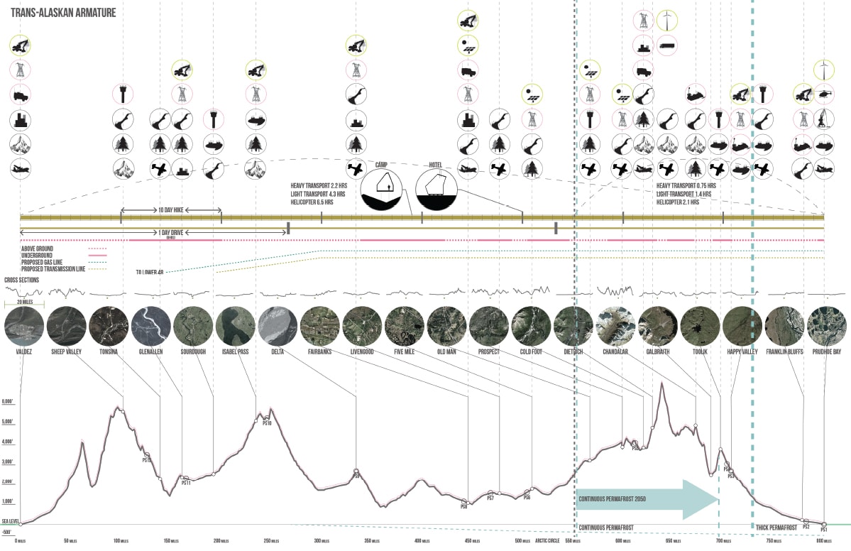
Multimodal extraction/transmission/tourism armature along the Trans-Alaska Pipeline, using former construction camps as nodes. UPenn Studio, “Territories of Extraction,” Spring 2014. Student work “Crude North” by Mike Smith
The stretching of transport infrastructure across a landscape sets up a cascade of other changes along the line: taking the form of required infrastructural components such as pump stations along pipelines, or substations along power lines. But they can also take the form of supply roads, service roads, airstrips, quarries, concrete batch plants, and associated industries that spring up to support the construction of the new infrastructure. Or they can take the form of construction camps for workers, which in turn attract services like stores, hospitals, and water and sanitation. Along the Trans-Arabian Pipeline in the Middle East, worker camps at pump stations grew into permanent settlements in the desert [23]; along the Trans-Alaska Pipeline in the Arctic, a handful of former construction camps have grown into small towns, while other construction camps have found new lives as arctic research stations, truck stops, and motels along the pipeline route. The Alaska pipeline’s supply road has become the Dalton Highway, the only public access highway to the upper reaches of the Alaskan Arctic and the North Slope.
Infrastructures of conveyance are engineered and built as self-contained “technological objects,” [24] geared for maximum efficiency, but in fact have second lives that lie outside of their design specifications. Old oil pipelines have been considered for repurposing into pipelines for carrying irrigation water [25]. Myriad railroad easements have found new uses as recreational corridors. Transmission line rights-of-way have been colonized as mountain bike runs, as seen on the steep slopes below Raccoon Mountain Dam in Chattanooga, pierced by high-voltage transmission corridors and off-road bike trails.
Alternative energies are typically presented as self-contained hermetically sealed technological objects, not as viable catalysts of landscape transformation. But despite the fights over large solar and wind installations, their biggest landscape impact may be not in the sites of generation, but rather along their landscapes of intensification. Certainly there are some well-documented environmental impacts to desert tortoise habitat [26] from massive solar thermal plants like Ivanpah, or to birds and bats by large-scale wind farms in the Great Plains, but the larger impact to the landscape will be from the tens of thousands of miles of new high-voltage transmission line that will be needed to bring many of the new planned renewable energy installations into the urban grids along the coast. Along the routes of the new corridors, vast new hinterlands may be opened for further resource extraction or for recreation and play. Like the Dalton Highway, what begin as service roads may become public highways, and what start as work camps may be seeds for tourism infrastructure. These new transmission corridors may come to represent the public’s primary access routes into public desert landscapes, supported by rest stops, campsites, businesses, and other outposts. Beyond mitigating the aesthetic and cultural impact of this technological invasion, how might designers actively couple these landscapes of intensification with opportunistic synergies and newly imagined cultural landscapes?
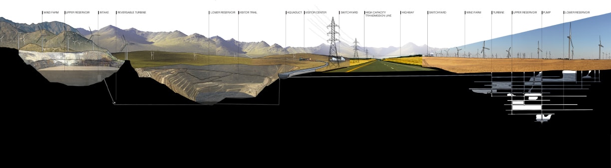
Multipurpose pumped-hydro energy storage landscape on remediated Abandoned Mine Land. UPenn Studio, “Territories of Extraction,”
Spring 2014. Student work “Mines to Megawatts” by Muhan Cui
Energy Transition: Grids and Batteries
From the adoption of water power, to that of steam, to electrification, to oil and natural gas, each new energy regime of the last two centuries has taken 40 years or more to become fully incorporated into the economic and social fabric of the nation, from introduction to widespread dominance [27]. Today, we face a new moment of energy transition, and although the technology that would replace fossil fuels is not brand new, the scale of the transition that must occur to achieve a meaningful decarbonization of the U.S. economy will need to be much faster than past transitions.
New transmission lines and connections to centers of consumption are one critical missing piece, as just described. But in the case of solar and wind power, the intermittent nature of their electrical generation adds another major obstacle to their incorporation into a new energy regime. Today’s electric grid was not built for energy storage, and so it must respond to energy demand in real-time, maintaining a near-constant voltage in the grid at any moment: grid operators ramp up energy production to match demand and shut off turbines when demand drops off. The operators seek to avoid sudden dips in voltage, which would send power outages cascading through the grid, and to avoid sudden spikes, which might blow out electronics, computers, and household appliances across entire urban areas. They rely on natural gas “peaker plants” that can be fired up quickly, within minutes, when demand starts to climb, in order to maintain a constant voltage.
Sun and wind are problematic power sources, since they can suddenly go quiet under cloudy skies or in still weather, leaving holes in supply that peaker plants cannot fill fast enough. Energy storage would buffer the sudden and intermittent nature of solar and wind production. Without a vast expansion in storage, wind and solar renewable energy will be unable to play at scale in the grid mix.
There are many different storage technologies, but they all operate on one of three basic modes: chemical, thermal, or mechanical. Batteries represent the most widespread form of chemical storage; long too expensive to deploy at scale, they have been getting cheaper as companies like Tesla get into the battery mass-production business. Other examples of chemical storage take the form of hydrogen or methane, but these require specialized industrial processes to make and tap. Thermal storage takes the form of heat or cold: some newer solar thermal plants have begun to incorporate molten salt, which can be superheated and tapped to keep making steam for the turbines after the sun has set. Other experiments in thermal storage are making ice during periods of energy abundance, and tapping it for thermal cooling during peak demand. But mechanical storage, in the form of pumped-storage hydropower, is the most interesting storage technology for its ability to operate at scale. Accounting for 95% of all storage in the U.S. grid, [28] pumped storage hydropower can achieve enormous scales, turning topography and mountain terrain into massive, dynamic, landscape batteries.
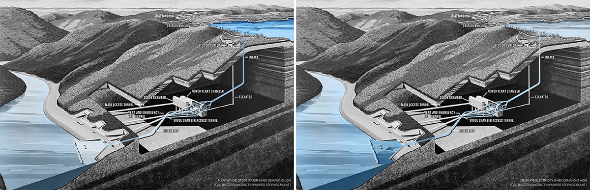
Analysis of Raccoon Mountain Pumped Storage Facility. UPenn Studio, “Territories of Extraction,” Spring 2014. Student work “Mines to Megawatts” by Muhan Cui, based on “Raccoon Mountain: A Hydroelectric Marvel”
Needing only gravity and two reservoirs at different heights, pumped storage hydro makes topography the main determinant of energy storage potential. Some closed-loop systems use two large artificial pools; the TVA’s open-loop pumped storage plant in Chattanooga employs a vast reservoir built into the top of Raccoon Mountain on the edge of town, and the adjacent Tennessee River as its lower reservoir. At night when both energy demand is low and there is excess energy being produced, the bowled landscape within the upper reservoir begins to fill; in the daytime and on evenings as demand rises, the reservoir begins to drop, rushing past two pairs of turbines and releasing 1500 MW of electricity for the region [29]. The landscape at the top is as much a public attraction as it is a dynamic, machinic landscape.
In lieu of ideal sites like Raccoon Mountain, energy companies have increasingly turned to former sites of mining — caverns and quarries dug into bedrock, or massive retired open-pit mines, as ready-made reservoirs that might provide pumped storage potential. Abandoned mine lands dot the Western landscape, with over 48,000 abandoned mines on public land at BLM’s last count [30]. Many of these sites are toxic remnants of bankrupt mining operations, in need of remediation but unlikely to ever get it. Among these thousands are handfuls of perfect sites for pumped hydro energy storage — mountaintop mines within easy reach of new wind and solar corridors of intensification. By repurposing these legacy landscapes for energy storage, federal agencies can not only subsidize the energy transition, but can tap the economic opportunity of the renewable energy economy in order to clean up the toxic mess of the former mineral extraction regime. Distributed across the landscape as a network of connected sites, pumped storage hydro as a national project at the regional scale would demand a systemic design language, and offer an opportunity to make legible a new energy landscape typology.
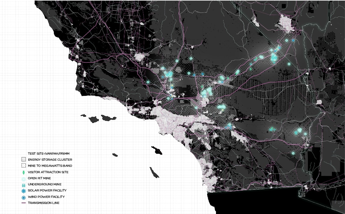
Potential abandoned mine lands next to planned high-capacity transmission lines along projected 2050 Los Angeles-Las Vegas urbanization corridor. UPenn Studio, “Territories of Extraction,”
Spring 2014. Student work “Mines to Megawatts” by Muhan Cui
Synthetic Transition
Energy policy is typically decided on the basis of pragmatism and palatability: that which will keep the electricity flowing and the bills low. This palimpsest of overlapping designs, patches, and short-term fixes has resulted in a fragile and chaotic grid in constant danger of collapse. The energy transition necessitates a redesign of virtually all aspects of today’s outdated grid — from generation, to transmission, to storage, to metering. Allies of renewable energy in the American West can either fight for each component of a complex and massive new energy regime against the entrenched backers of the oil and gas age, or they can provide a bold inclusive vision for a novel energy landscape that eclipses old rivalries: a new multipurpose system of public lands, a TVA on an even grander scale.
To guide responsible and sustainable management of public lands for energy production, there is opportunity to reimagine Multiple Use to include not just extraction and environmental protection, but a robust synthesis of natural and industrial flows. A boom in solar power, for example, could affordably fuel purification of groundwater long tainted by farming and the oil industry, which in turn could support new habitats, such as “walking wetlands” [31] that enable bird migrations. Tomorrow’s renewable transmission corridors can be designed with both habitat and recreation in mind, by imagining utility easements not disruptions in a pristine wilderness but as networks of vast regional recreational armatures that offer landscape connectivity across a patchwork landscape. New landscapes of extraction present an opportunity to reimagine a 21st-Century Multiple Use Mandate — one which considers a diversity of interests and actors, ecosystem services, and economic opportunities, and embraces social and ecological complexity over very long time scales.
The project of multifunctional renewable energy armatures is a megaregional project — and it demands an infrastructural and landscape imagination on the scale of the greatest public works campaigns of the 20th century.
Nicholas Pevzner teaches in the Department of Landscape Architecture and Regional Planning at the University of Pennsylvania School of Design. He is a co-editor of this issue.
Notes
[1] The White House Office of the Press Secretary, “FACT SHEET: U.S. Reports its 2025 Emissions Target to the UNFCCC,” March 31, 2015, accessed September 25, 2015, https://www.whitehouse.gov/the-press-office/2015/03/31/fact-sheet-us-reports-its-2025-emissions-target-unfccc.
[2] Bureau of Land Management, “BLM Fact Sheet: Renewable Energy: Solar” [Fact sheet], May 2015, accessed September 7, 2015, http://www.blm.gov/style/medialib/blm/wo/MINERALS__REALTY__AND_RESOURCE_PROTECTION_/
energy/solar_and_wind.Par.99571.File.dat/fact_Solar.pdf ; Bureau of Land Management, “BLM Fact Sheet: Renewable Energy: Wind” [Fact sheet], May 2015, accessed September 7, 2015, http://www.blm.gov/style/medialib/blm/wo/MINERALS__REALTY__AND_RESOURCE_PROTECTION_/
energy/solar_and_wind.Par.38552.File.dat/fact_Wind.pdf.
[3] Argonne National Laboratory, “Impacts of Long-Term Drought on Power Systems in the U.S. Southwest – July 2012,” prepared for Department of Energy, Infrastructure Security and Energy Restoration Division (2012): 11, http://energy.gov/oe/downloads/impacts-long-term-drought-power-systems-us-southwest-july-2012.
[4] David E. Nye, American Technological Sublime (Cambridge and London: The MIT Press, 1994).
[5] Dirk Sijmonds has offered visualizations of how the switch to renewables might impact his native Netherlands. We can expect similar conflicts in the United States. See Dirk Sijmons et al., ed., Landscape and Energy: Designing Transition (Rotterdam: Nai010 publishers, 2014).
[6] The TVA came out of a regional planning imagination that re-imagined the entire 7-state watershed region transformed on a number of levels. It combined civic architecture with social engineering and regional infrastructure development. Keller Easterling discusses both the TVA and the Appalachian Trail as regional projects that aimed to radically reorganize the landscape through an infrastructural reading of nature, and Benton Mackaye’s role in both. For example, see Keller Easterling, “Network Ecology,” Felix: Landscape(s), (2), no. 1 (1995): 258-265.
[7] In 2009, DOI Secretarial Order 3285 identified the development of renewable energy on public land as a priority for the Department of the Interior. See: U.S. Department of the Interior, Secretarial Order 3285, Amendment No. 1 (February 22, 2010), available at http://elips.doi.gov/ELIPS/0/doc/151/Page1.aspx.
[8] Executive Office of the President, “The President’s Climate Action Plan,” June 2013, accessed September 5, 2015: 7, https://www.whitehouse.gov/sites/default/files/image/president27sclimateactionplan.pdf.
[9] “BLM Fact Sheet: Renewable Energy: Solar” [Fact sheet] ; “BLM Fact Sheet: Renewable Energy: Wind” [Fact sheet].
[10] As set out in the Federal Land Policy and Management Act of 1976. U.S. Department of the Interior, Bureau of Land Management and Office of the Solicitor (editors). 2001. The Federal Land Policy and Management Act, as amended. U.S. Department of the Interior, Bureau of Land Management Office of Public Affairs, Washington, D.C. 69 pp
[11] As set out in the Multiple-Use Sustained-Yield Act of 1960, http://www.fs.fed.us/emc/nfma/includes/musya60.pdf.
[12] Charles Austin Beard, ed. Readings in American Government and Politics, (New York: Macmillan, 1910), 369-370.
[13] Jessica Goad, Christy Goldfuss, and Tom Kenworthy, “Using Public Landsfor the Public Good: Rebalancing Coal and Renewable Electricity With a Clean Resources Standard,” (Center for American Progress, 2012): 8, https://cdn.americanprogress.org/wp-content/uploads/issues/2012/06/pdf/public_lands.pdf.
[14] Rick Heede, “Memorandum to Dunkiel Saunders and Friends of The Earth,” Climate Accountability Institute, 2015, available at: http://webiva-downton.s3.amazonaws.com/877/3a/7/5721/Exhibit_1-1_ONRR_ProdEmissions_Heede_7May15.pdf.
[15] Goad, Goldfuss, and Kenworthy, 8.
[16] Ted Nace, “Which has a bigger footprint, a coal plant or a solar farm?” Grist, accessed October 5, 2015, http://grist.org/article/2010-11-17-which-has-bigger-footprint-coal-plant-or-solar-farm/.
[17] Gifford Pinchot, “The Use of the National Forests” from The Use of the National Forests (USDA Forest Service publication, June 14, 1907), 15-24.
[18] Alan Berger has documented many legacies of extraction both in his book Reclaiming the American West, and on his web-based project Waste2Place. See Alan Berger, Reclaiming the American West (New York: Princeton Architectural Press, 2002).
[19] Christopher F. Jones, Routes of Power: Energy and Modern America (Cambridge: Harvard University Press, 2014): 6-9.
[20] Ibid., 9.
[21] Edison Electric Institute, “Transmission Projects: At a Glace,” (Washington, D.C.: Edison Electric Institute, 2015): iii, available at http://www.eei.org/issuesandpolicy/transmission/Pages/transmissionprojectsat.aspx.
[22] “About Clean Line Energy,” accessed October 5, 2015, http://www.cleanlineenergy.com/about.
[23] Neeraj Bhatia, “ Harvesting Urbanism Through Territorial Logistics, in eds. Neeraj Bhatia and Mary Casper, The Petropolis of Tomorrow (New York: Actar D, 2013), 281-284.
[24] Brian Davis has discussed the easement as distinct from the “technological object” such as the railroad, pipeline, highway, or cable which generates the easement. See Davis, “Index of Landscape Typology: Easements,” in eds. Neeraj Bhatia and Mary Casper, The Petropolis of Tomorrow (New York: Actar D, 2013), 396.
[25] Neeraj Bhatia has described the repurposing of portions of the Trans-Arabia Pipeline for water transport in the Golan Heights, and the consideration of a similar conversion for a pipeline between Northern Canada and the U.S. Midwest. See Bhatia, “ Harvesting Urbanism Through Territorial Logistics, in eds. Neeraj Bhatia and Mary Casper, The Petropolis of Tomorrow (New York: Actar D, 2013), 284-285.
[26] Ken Wells, “Where Tortoises and Solar Power Don’t Mix,” Bloomberg Business, October 10, 2012, accessed October 5, 2015, http://www.bloomberg.com/bw/articles/2012-10-04/where-tortoises-and-solar-power-dont-mix.
[27] David E. Nye, “The United States and alternative energies since 1980: Technological fix or regime change?,” Theory, Culture & Society 31, no. 5 (2014): 107.
[28] Mark Johnson et al., “DOE OE Grid Energy Storage Report,” December 2013, available at http://www.sandia.gov/ess/docs/other/Grid_Energy_Storage_Dec_2013.pdf.
[29] “A Hydroelectric Marvel,” Raccoon Mountain Pumped Storage Facility, accessed October 5, 2015, http://raccoonmountainexperience.com/hydroelectric-marvel/.
[30] “Abandoned Mine Lands Inventory,” Bureau of Land Management, accessed October 5, 2015, http://www.blm.gov/wo/st/en/prog/more/Abandoned_Mine_Lands/abandoned_mine_site.html.
[31] Brett Milligan, “Landscape Migration: Environmental Design in the Anthropocene,” Places Journal, June 2015, https://placesjournal.org/article/landscape-migration/.