Introduction: Extraction

Extraction sustains our society. We rely on energy to power the technology in our lives but are disconnected from the landscapes that must be exploited to yield that energy. We dig and blast materials to construct and repair the physical infrastructure of our towns and cities, but rarely pause to think about the origin of the gravel, concrete, steel, foam and bitumen that comprise the built environment. We rely on rare earth metals to manufacture lifesaving medical devices and disposable electronics without considering the political consequences of rare earth smuggling or mine leachate on drinking water supplies. Globalized markets trade hard commodities without minding the origin of materials at all.

Still, extraction is always local. Raw materials are wrought from the earth, shaping the landscape physically in the process — chewing up the ground, hollowing aquifers, altering the composition of the oceans, jumbling the structure of soils. As the world population becomes more urban and more spatially removed from the landscapes that supply its raw materials and energy needs, as supply chains elongate and become more globalized, our reliance on remotely extracted natural resources only continues to increase, while our relationship to the landscapes of extraction recedes ever further from daily view.

This issue of Scenario Journal explores such landscapes of extraction and the networks of relationships that sustain them. Each piece brings us closer to a landscape and the processes of extraction that have shaped it over time, but they also ask in earnest, do we really understand these spaces at all?

Bert Kaufmann_Tagebau_Garweiler


Extraction is difficult to define. Grammatically, it is an action noun, an entity that refers explicitly to an activity — the pulling out, or the forcible taking of material from the earth, or from a body. Extraction, in the context of material resources, takes place across space and time. This abstract notion can be broken down into three primary components: material, form, and process.

Material

The raw materials from which our cities are built are extracted from discrete places. Once wrestled from the ground, from the water, or from the atmosphere, materials are transported across physical space to arrive at their destinations — actions that require both work and labor. Considering the origin of materials allows us to imagine the physical impact on real, if distant, landscapes.

The logistical and infrastructural connections of the city to its hinterland effectively expand the urban territory — connecting sites of extraction, conveyance, and consumption. As landscape architect Jane Hutton has written, “the study of paired landscapes of production and consumption generates a spatial framework for examining the social and ecological relations of their material exchange.” [1] Her essay, Reciprocal Landscapes: Material Portraits in New York City and Elsewhere, traces the paths from quarry, steel mill and forest to engineered urban landscapes, providing an example of richness and imaginative potential of such material mappings. While the physical materials used to construct buildings, landscapes, and infrastructure can be readily observed and traced, this practice is more difficult for the immaterial resources of energy production that powers every corner of our economy. To see the full impact of an urban project, we need to imagine the larger connections between that project and the landscapes that supplied its raw materials, energy and labor. Understanding these landscapes will involve reconciling the social and the physical, seeing landscape as a social construct, or as J.B. Jackson remarked, “as a concrete 3-dimensional shared reality.” [2]

It is fashionable these days to take great interest in where our food and beer comes from, yet we actively ignore the sources of far more impactful (and necessary) materials like copper and lanthanum. We prefer that hazardous raw materials come from somewhere far away. Other materials are so ubiquitous as to become invisible. “Like archeology, which is time read backwards,” says Lucy Lippard, “gravel mines are metaphorically cities turned upside down, though urban culture is unaware of its origins and rural birthplaces.” [3]

Mining, in particular, is primarily regarded as a means to an end, rarely seen as having any intrinsic value aside from economic benefits for an increasingly small few. The monetary value of raw materials regularly outweighs concerns about the practices and processes required to bring them to market. Oil, natural gas, and precious metals are considered too valuable to keep in the ground, rendering the value of the landscapes themselves insufficient.


Form

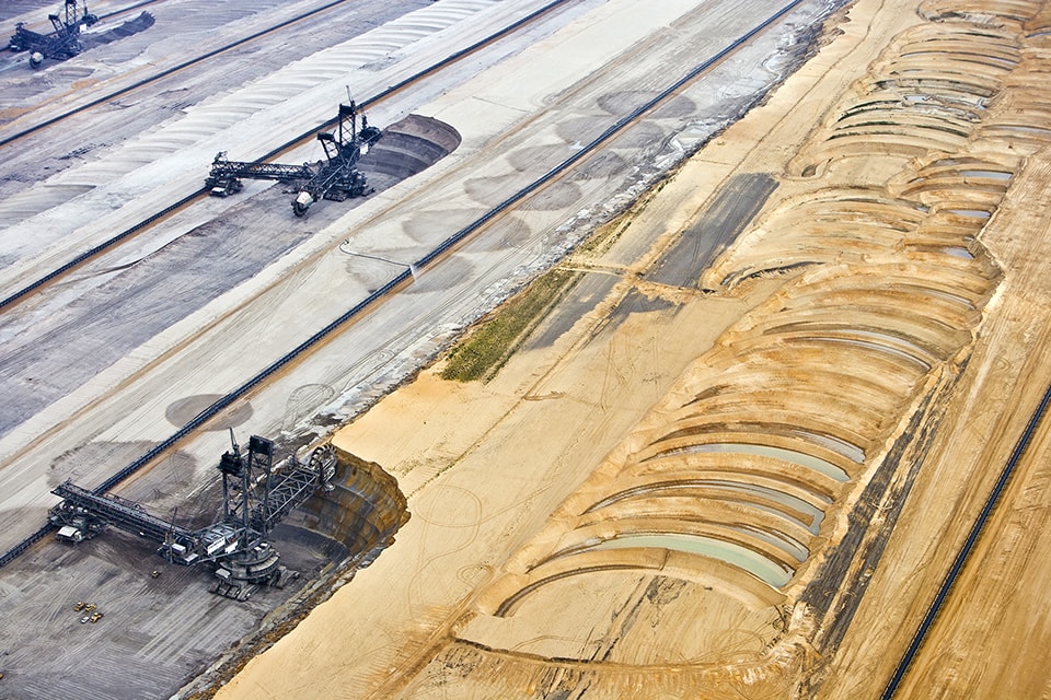
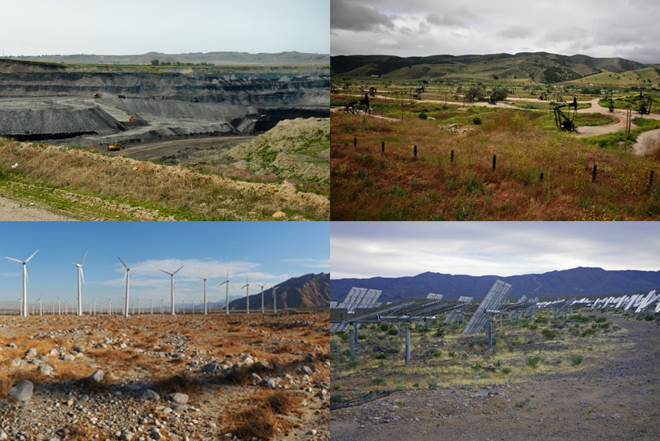
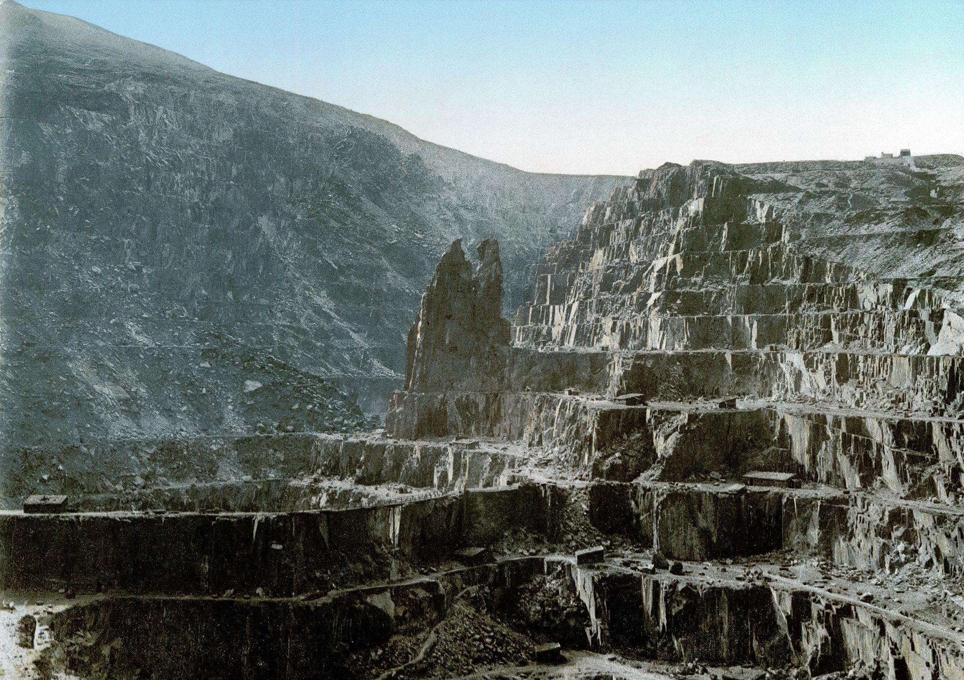
Still, when we do seek out landscapes of extraction, it is often the form of the pit, the mine, the quarry, or the well field that captures our imagination. After decades of breathtaking high-resolution aerial photography saturating the art world and popular media alike, large-scale land transformation tied to mega dams and open pit mining have become an integral part of our contemporary landscape imagination — a testament to human accomplishment and ingenuity to some, a source of deep concern to others.

While remote sensing and the ubiquitous nature of Google Earth has made some impacts and activities easier to see and comprehend, the physical form of extraction does not neatly correspond to environmental, social or economic impact. Some forms of extraction are so striking that they have come to represent the landscape sublime. Other forms of extraction are difficult to image.

The drama of a copper mine is more photogenic than the draining of an aquifer by a million tube wells. Indeed, the most profound systems of extraction are nearly invisible. Consider the deterritorialized extraction of atmospheric nitrogen (and its conversion into fertilizer through the Haber–Bosch process) that fueled the agricultural revolution, global population growth, and widespread land conversion. Physical forms, locked in time and space, rarely tell the full story.

Still, by looking deeply, we may begin to unpack the relationship between forms and the unseen networks that shape them. The form of the landscape is not arbitrary but contains within it traces of history and the pressures of present conditions. Form is a response to more complex, dynamic systems.

PublicDomain_Slate Quarry Wales

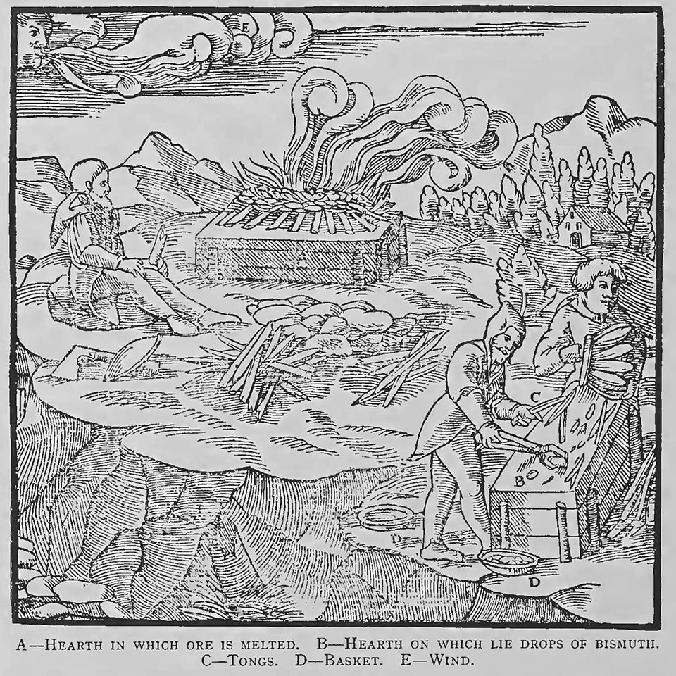
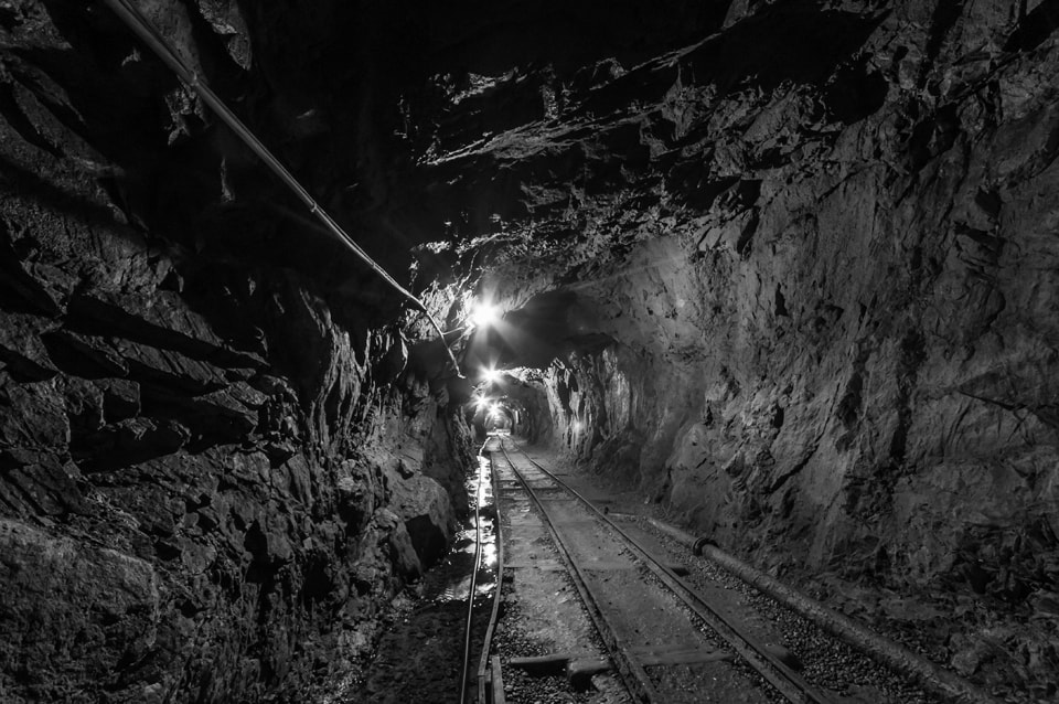
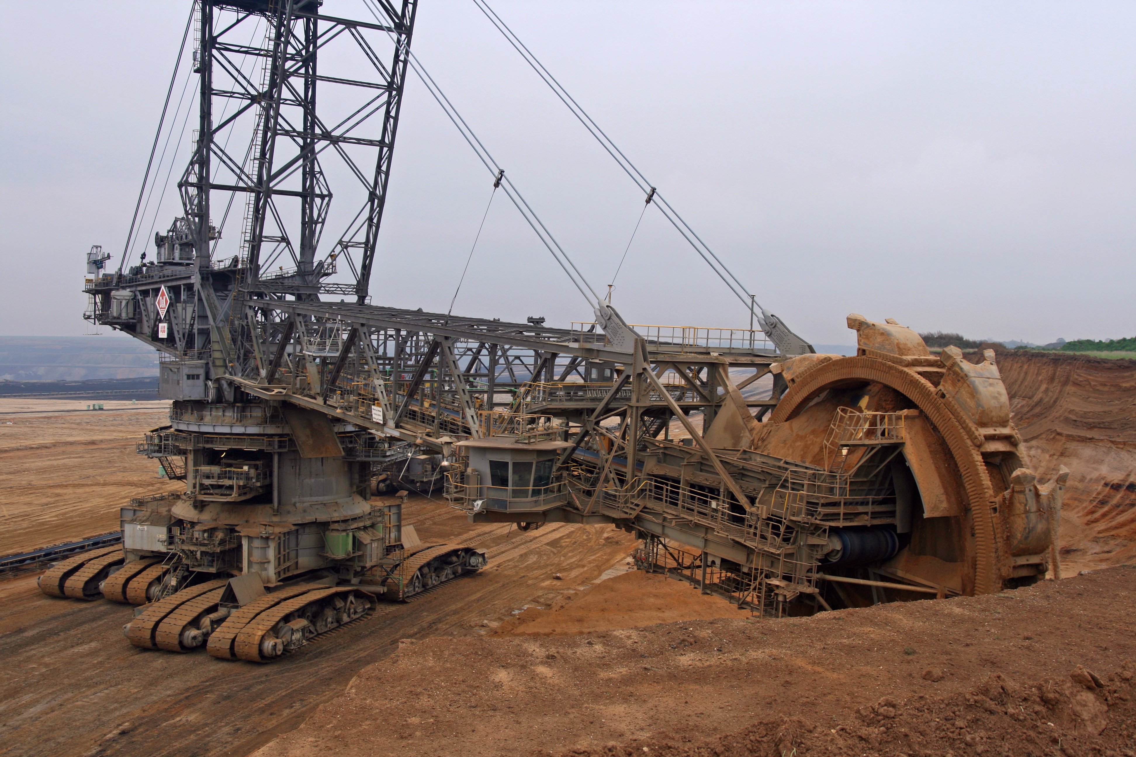
The physical forms of extraction operations depend on the intersection of ancient geology, contemporary technology, and dynamic markets. For example, at the turn of the previous century, old mines followed seams of mineral ore primarily underground, tunneling along the seam beneath pristine landscapes and urban areas. As mining technology developed and extraction industries consolidated, it became feasible to excavate huge open pits, and not just tunnels, despite the need to process literal mountains of overburden. Rising mineral prices and bigger machines made the low-quality dregs of “exhausted” and bankrupt mines once again ripe for re-extraction. The form of the mine, and the experience of the miner, were altered completely by a combination of markets and machinery.

Contemporary mining projects can also be understood as complex, dynamic objects. Architect Liam Young, in his description of a gold mine in Western Australia, captures a gold mining operation’s fine-tuned response to market forces: “based on gold prices, the pit model changes…if the gold price or the mineral price is higher, then the pit gets wider as it becomes cost-effective to mine areas of lower concentration. This happens nearly in real time—the speed of the machines digging the pit can change over the course of the day based on the price of gold, so the geometry of the pit is utterly parametric, modeling these distant financial calculations.” Based on speculative models of ore bodies embedded in geological formations, mine operators balance extraction economics, angles of repose, mechanical considerations, surface constraints, and so on: “the shape of the ensuing pit is not the result of frantic, directionless digging, but of a carefully controlled design process.” [4]


Process

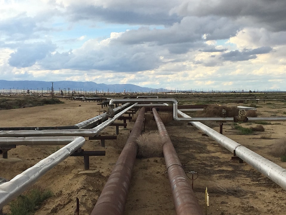
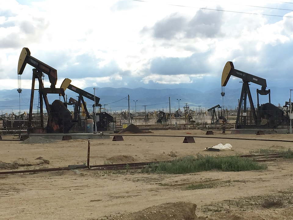
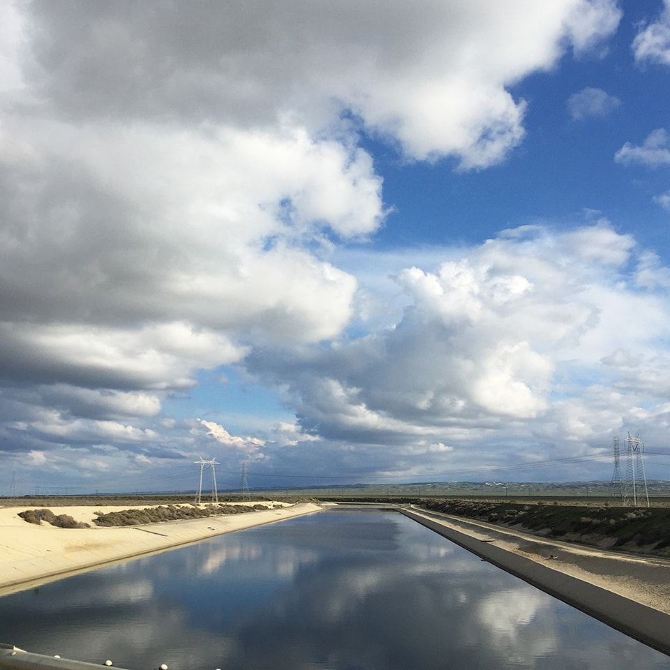
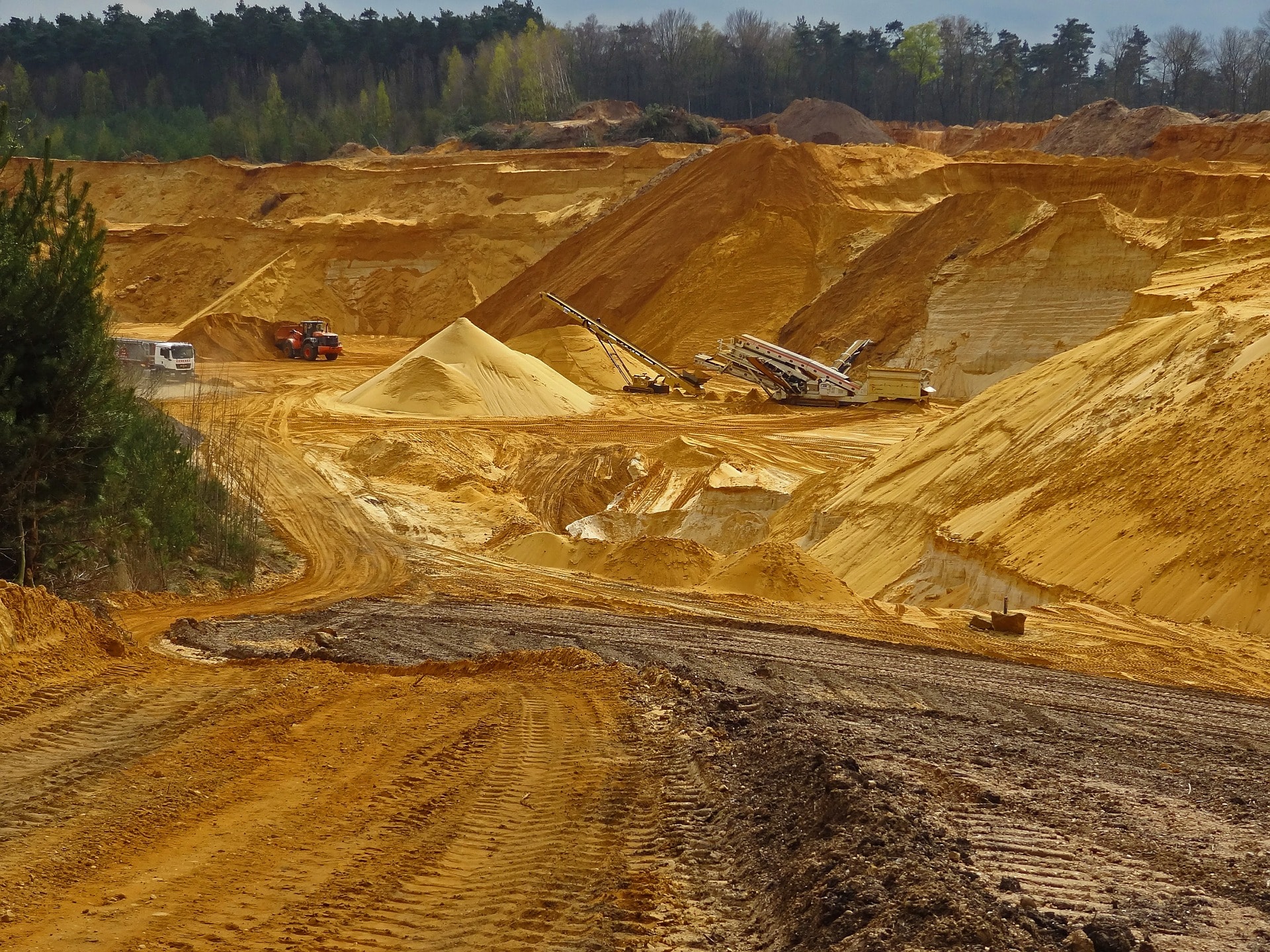
The literal process of extraction reveals still more layers interconnection. Understanding the material and logistical mechanisms of extraction allow us to see that multiple extractive processes are often interconnected, and form webs of complex feedback loops that link disparate landscapes. The fracking boom in the Marcellus and Bakken shales, for example, has accelerated the mining of silica sands across the Midwest, displacing farmlands, forests, and even settled areas, and raising fears of an imminent sand shortage. In California, the draining of ever-deeper aquifers — so-called fossil waters, accumulated over millions of years — has been made possible by the repurposing of a new generation of oil drilling rigs, designed and built for the shale fracking boom: fossil water extraction paralleling the tapping of fossil mineral reserves. [5]

open-pit-sand mining-567722_1920


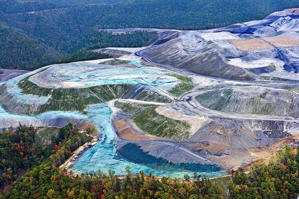
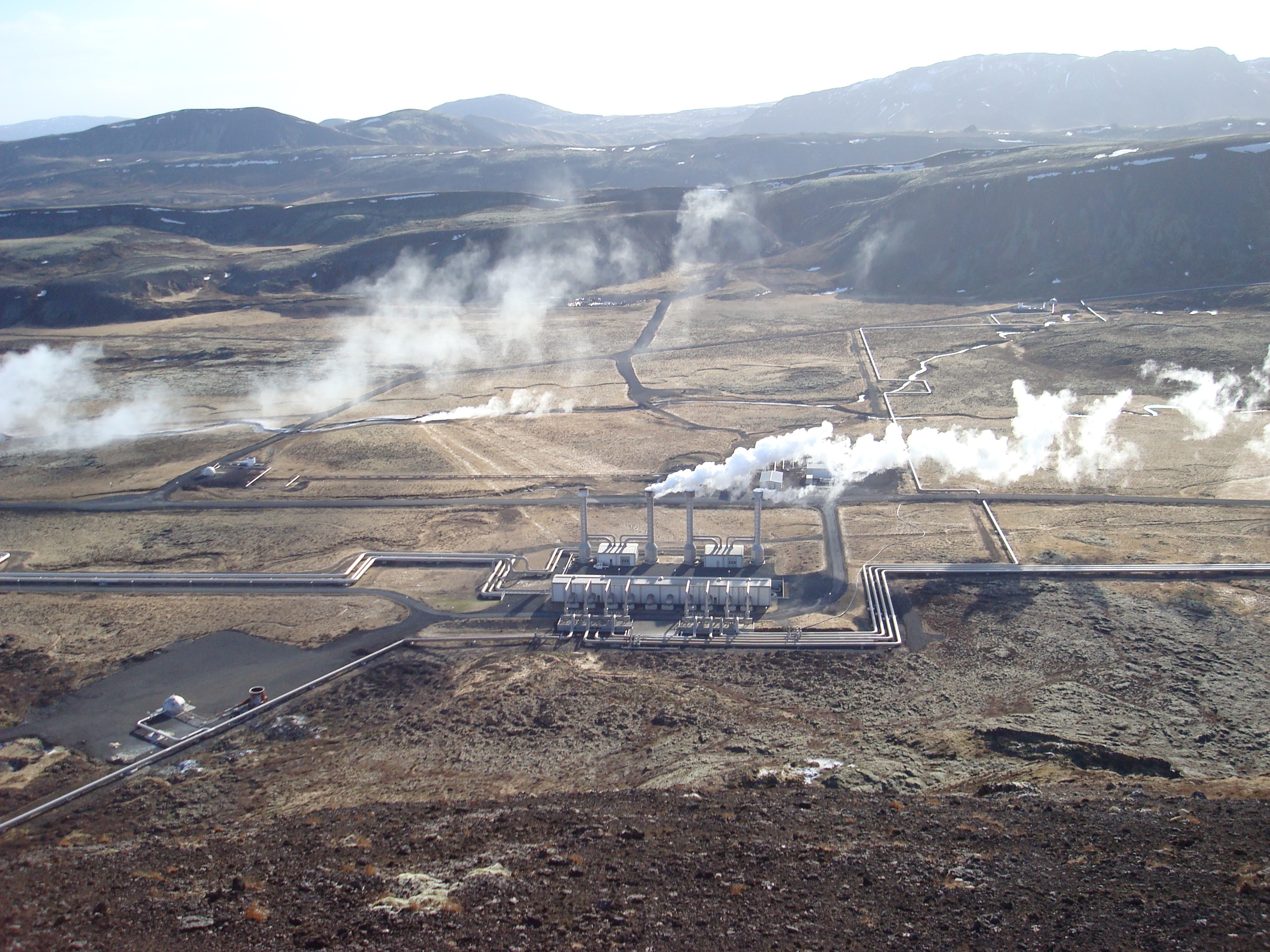
Often the hidden material that supports or is impacted by another, seemingly unrelated form of material or energy extraction is fresh water. Extraction processes often affect water resources in dramatic and invisible ways, driving large-scale environmental change. Ore processing as part of mining demands large amounts of water, which ends up in colorfully toxic tailings ponds; the hydraulic fracturing extraction boom likewise demands the direct use of water in huge amounts, altering both surface and sub-surface flows. Other forms of energy production — even renewable ones like solar- and geothermal power plants — also use large amounts of water, to the extent that the coupled relationship of water in energy production, and energy in water supply and treatment, are collectively referred to as the energy-water nexus.

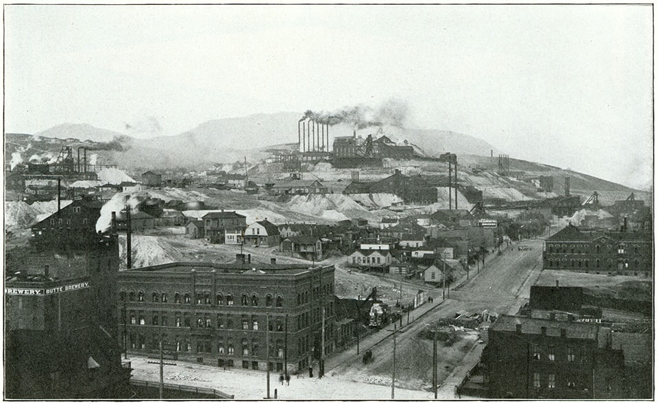
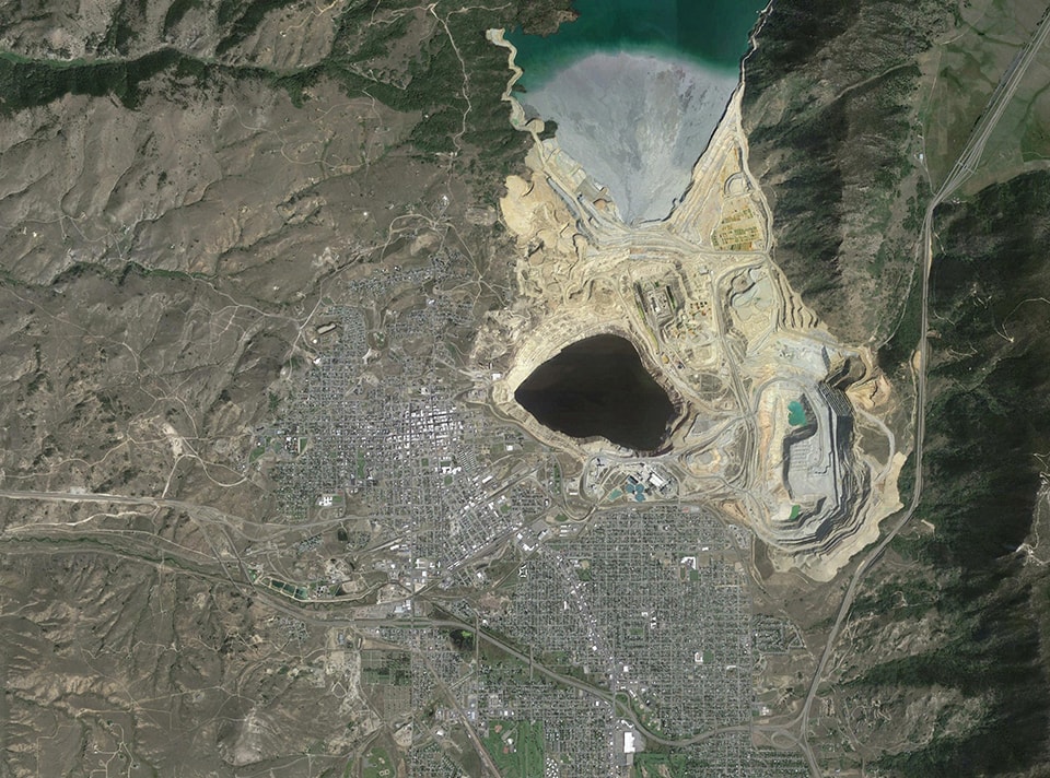
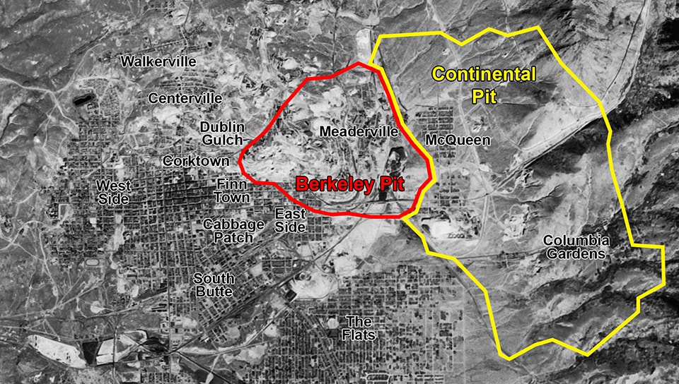
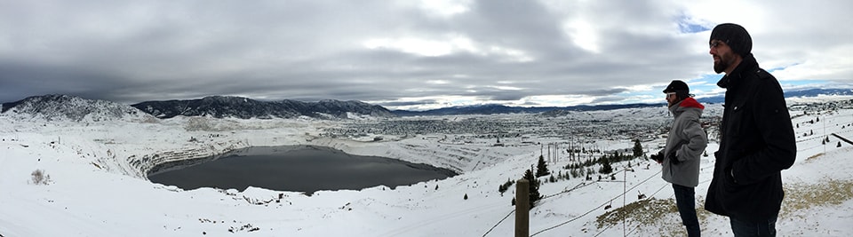
In addition to the direct consumption of freshwater resources, mines and quarries routinely dig below the water table; when these facilities eventually close down and pumping stops, the holes fill back up with groundwater, now laced with byproducts of the mining process. In Butte, Montana the water in the massive Berkeley copper pit documented by Bradford Watson and Sean Burkholder in their essay is still steadily rising more than 30 years after the mine has closed, bringing home a basic hydrological principle to residents long used to being disconnected from natural processes in a dramatically engineered extraction landscape.

Today the mining of groundwater is rapidly converging with the traditional narratives of oil extraction. Speculation, traditionally the purview of the commodities sector, has become the norm in drought-ridden California, as hedge funds compete to grow the most water-intensive crops and out-compete smaller farmers who can’t afford deep wells. Economic activity unleashed by extraction in one place drives urban growth and patterns of consumption in geographically distant, but economically tethered locations.

Beyond the material landscape, extraction also catalyzes, and relies upon, dynamic networks of transportation and invisible economic subsidies. Generations of ever-cheaper transportation infrastructures (from canals and railroads to pipelines and ever-larger ocean-going vessels) have resulted in an extended network of extraction and consumption. Historically low-value materials such as coal or crushed rock, which tended to be extracted, processed, and sold locally, can now move long distances. Both gold and coal from Australia can now be profitably shipped halfway across the world, and lithium from Bolivia can fuel high-tech manufacturing in China, as shown by Unknown Fields Division’s global treks in search of the interconnected global extraction landscape.

Thanks to the globalization of material supply chains, and continuing decreases in the cost of shipping, the actual places of extraction for the thousands of materials and components of a gadget or building project are scattered around the world — distance has long ceased to be the primary, or perhaps even a relevant, determinant of material availability.

DSC05576


Extraction cannot be regarded as an activity in isolation. Indeed, extraction is followed by transformation. It is not raw materials alone that are moved from place to place — individuals and communities migrate for work and so too are transformed. Capital changes hands as riches are made or lost.

This issue attempts to move beyond clear binary stances on the positive or negative impacts of extraction. Collectively these pieces present extraction as a condition rooted in history, actively transforming the future of the landscape and along with it communities, economy, equity, and technology. They examine the spatial disconnect between the city and its hinterland, but also ask how contemporary cities can begin to offer meaningful connections to their extraction landscapes.


The Essays

The pieces in this collection bring us to the sites of extraction of a range of materials (coal, gold, water, oil, gravel, copper). They also call attention to the extraction of immaterial substances (wind, solar radiation) that shape the landscape nonetheless.

Gavin Bridge sets the philosophical ground for the mine and the hole as spaces that concentrate and squeeze value, time, and labor into discrete geographic moments. In The Hole World: Scales and Spaces of Extraction, he investigates the relationship between the disembodied notion of energy and the specific geological and spatial formations that supply its raw materials. Value is made material, as the operations of the hole compress time and set into motion massive flows of both waste and wealth.

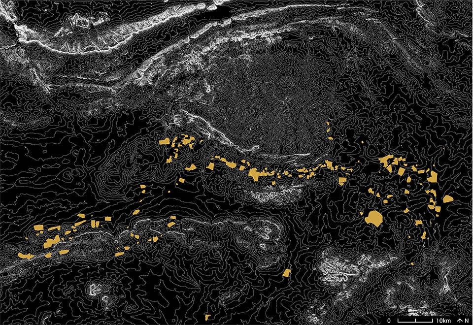
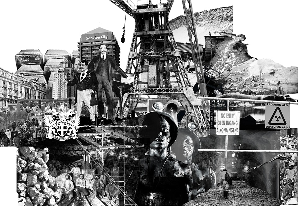
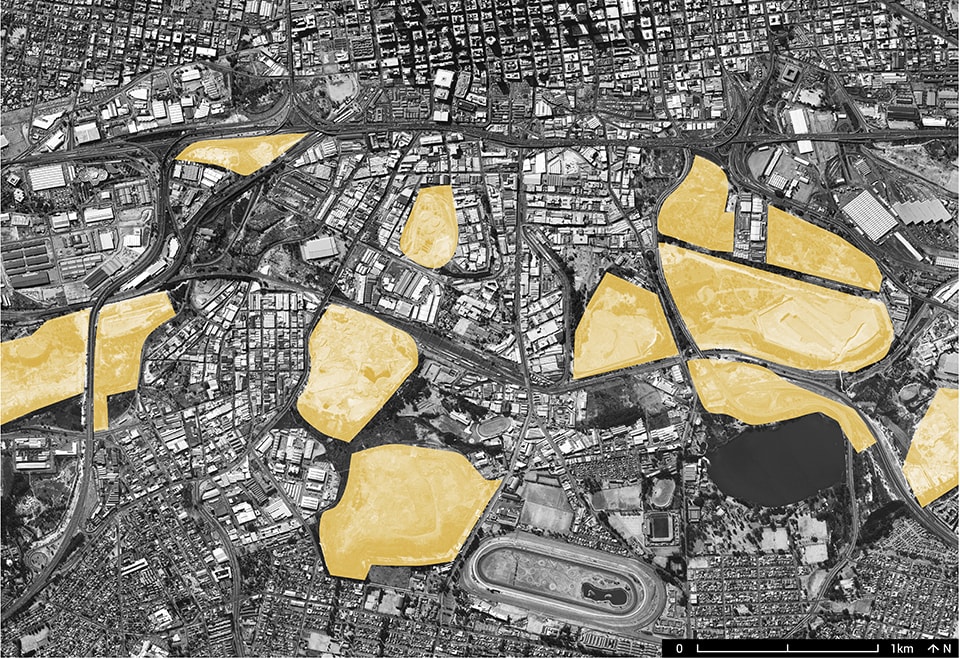
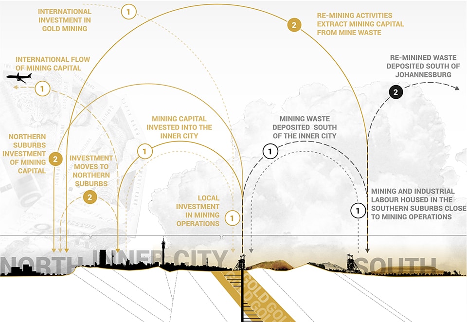
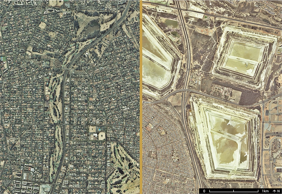
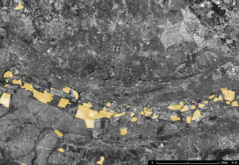
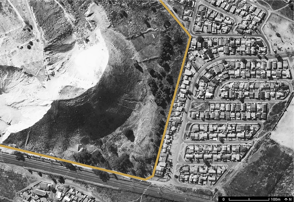
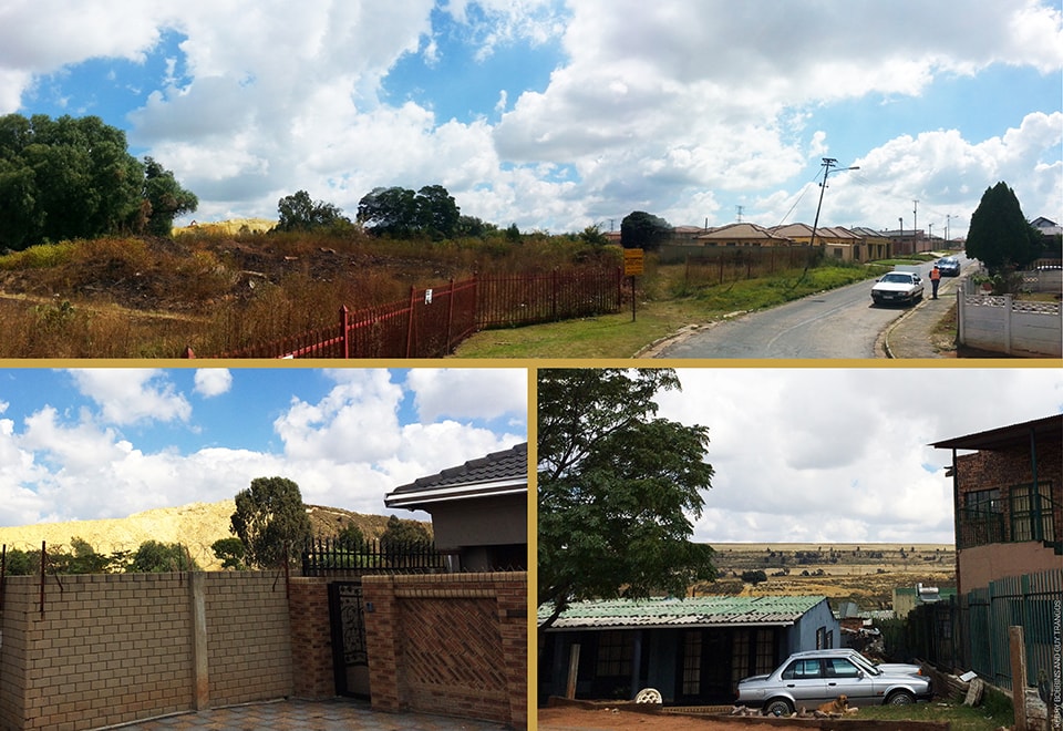
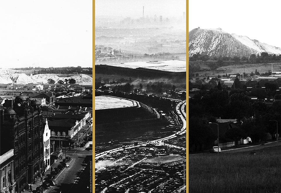
Several essays in this issue explore the identity of settlements that co-exist in physical proximity to their landscapes of extraction, drawing from them their sustenance but simultaneously coping with their legacies of environmental disturbance. Bradford Watson and Sean Burkholder, in Butte, Montana: a Case for the Mining Metropolis, examine the historic mining boomtown as a prime example of a city that grew up on over a century of continuous mining, drawing its culture and its wealth from the massive pit next door that eventually came to dominate the town. In Gold Mining Exploits and the Legacies of Johannesburg’s Mining Landscapes, Guy Trangoš and Kerry Bobbins look to Johannesburg, South Africa, a city founded on gold extraction, where the toxic spoils of this history remains visible throughout the city, decades after the boom has ended.

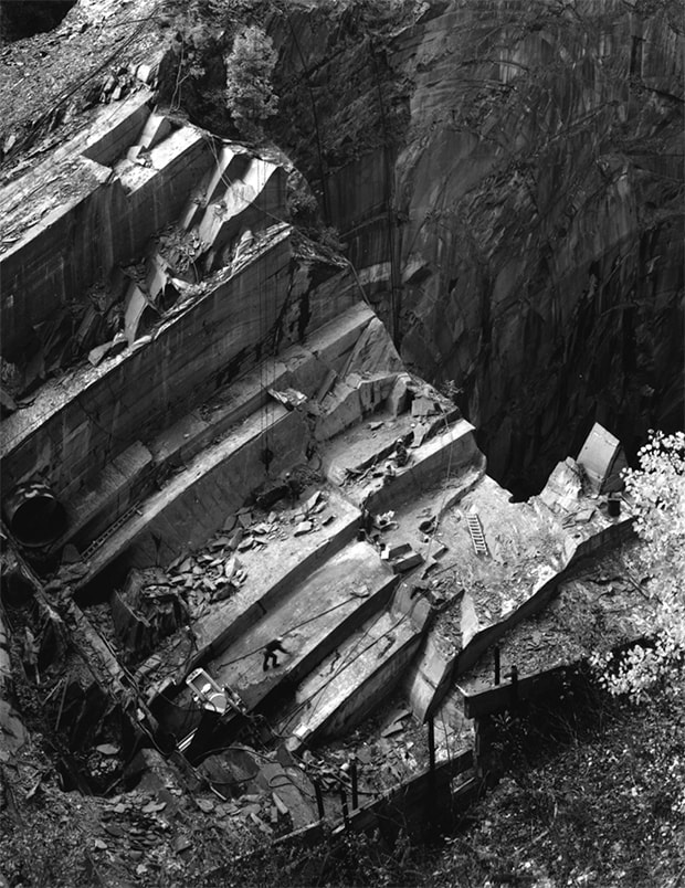
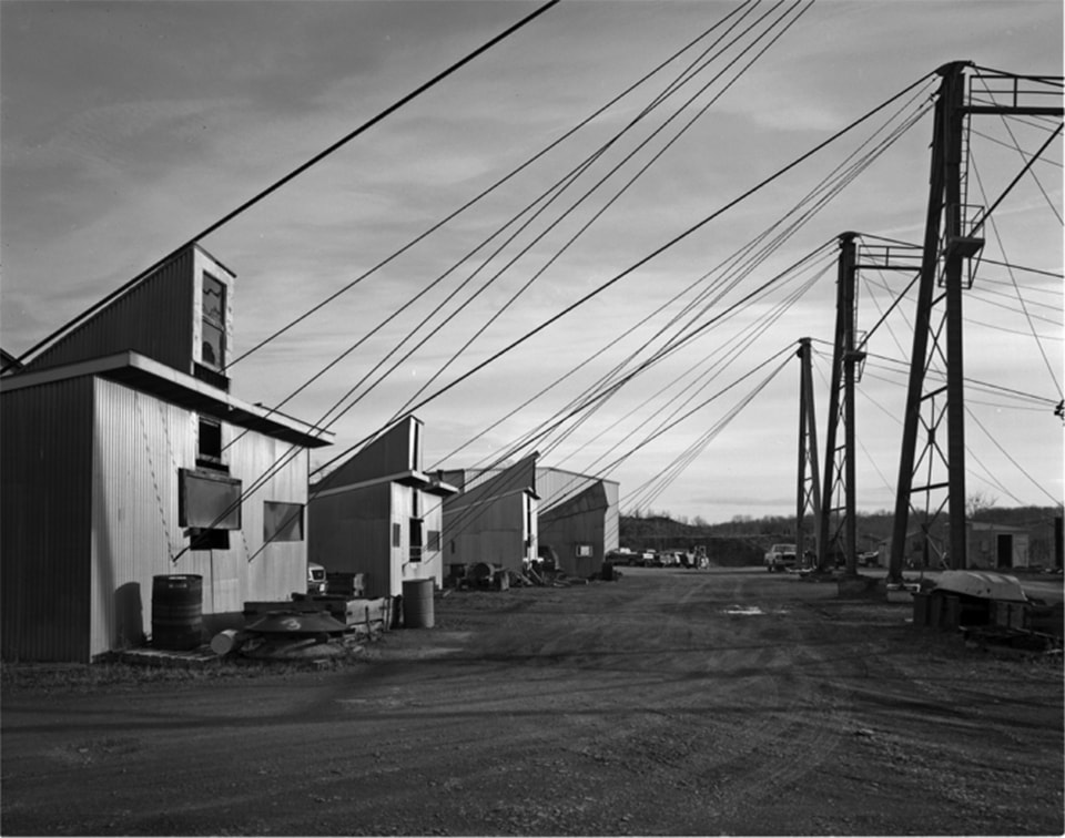
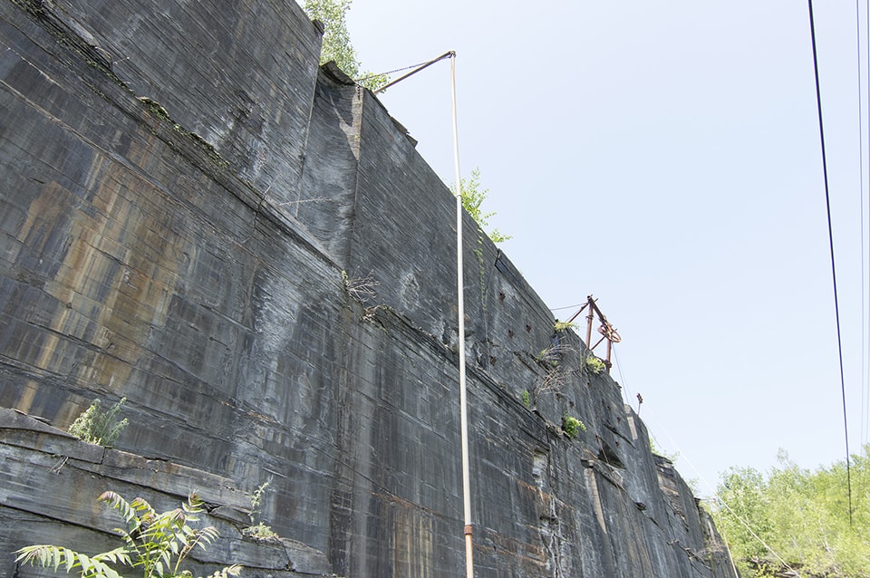
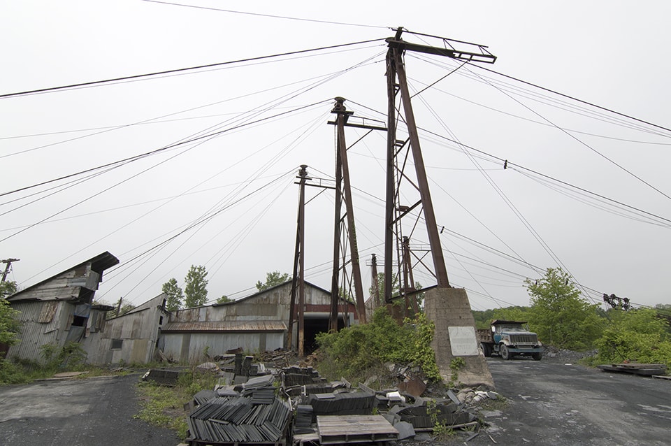
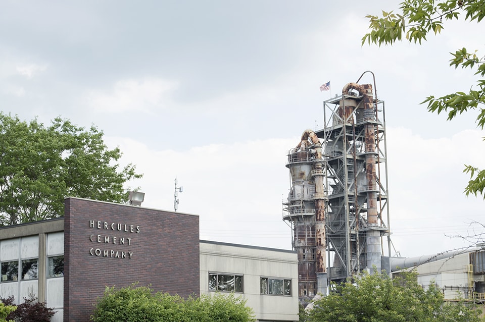
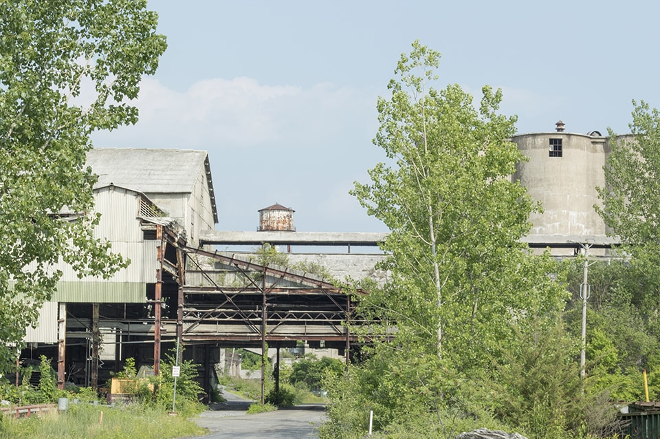
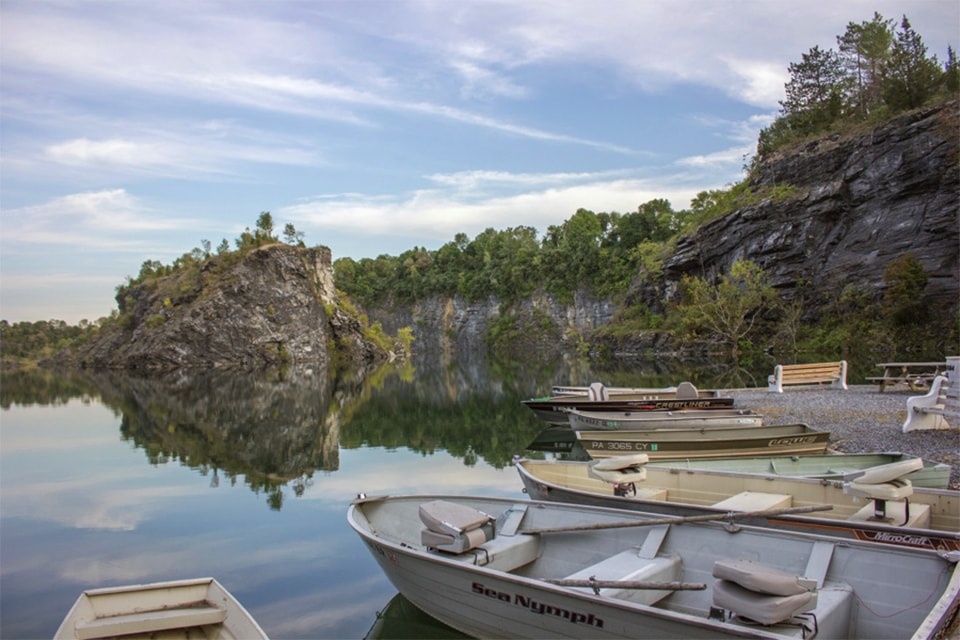
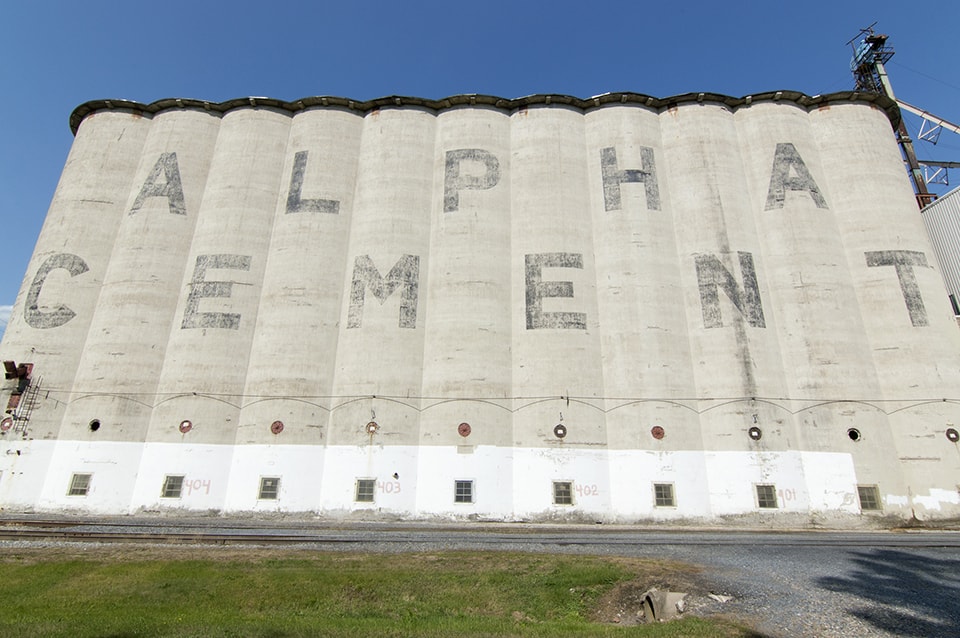
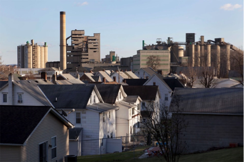
Frank Matero’s Pit and Quarry: The Cement and Slate Landscapes of Pennsylvania, meanwhile, looks at a region whose history lay in building materials — steel and cement production, coal mining, and slate. He asks how we might best preserve this iconic industrial heritage and these historic extraction landscapes.

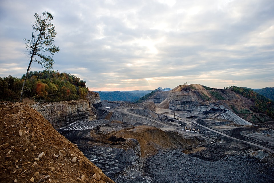
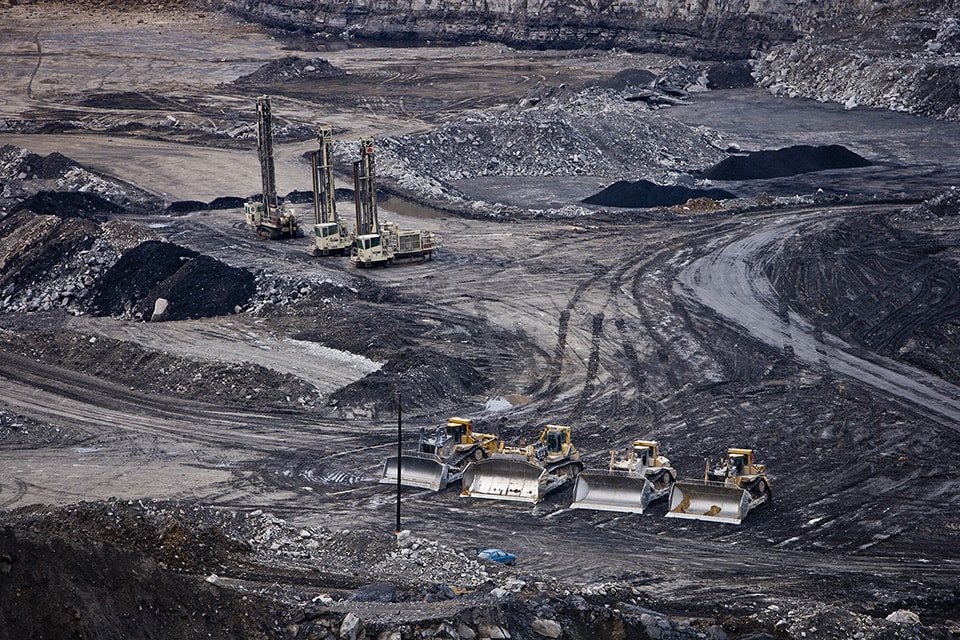
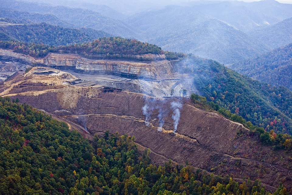
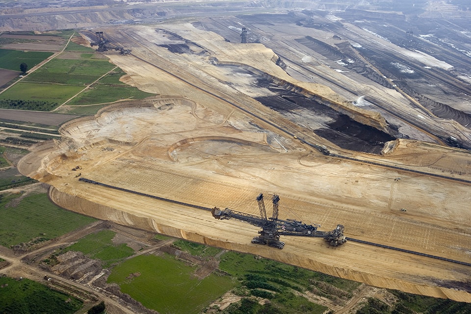
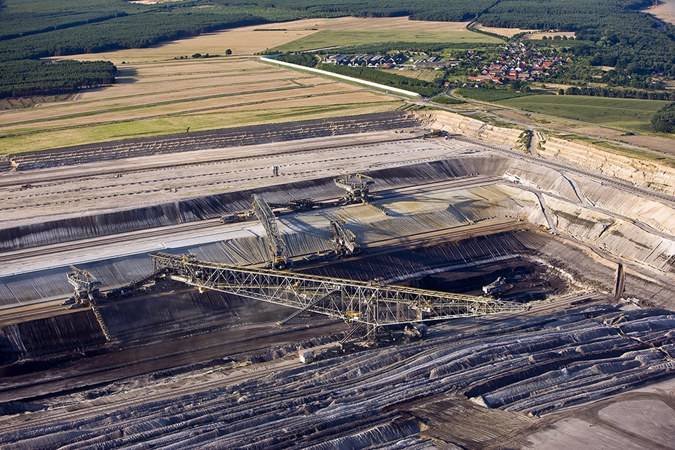
Henry Fair brings us to the site of two forms of coal mining in his photo-essay, The True Cost of Coal: The First Installment, the rugged rural terrain of Appalachia, and the flat agricultural expanses of Germany. Alex Breedon’s A Monument to Mining, proposes an elegant gesture that acknowledges the link between metropolis and mine.

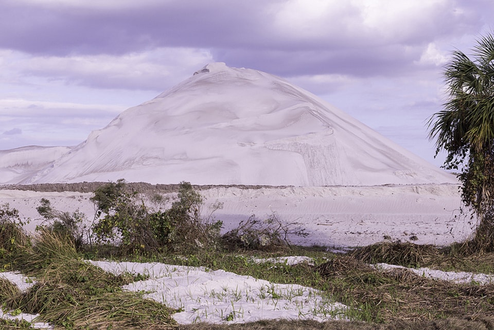
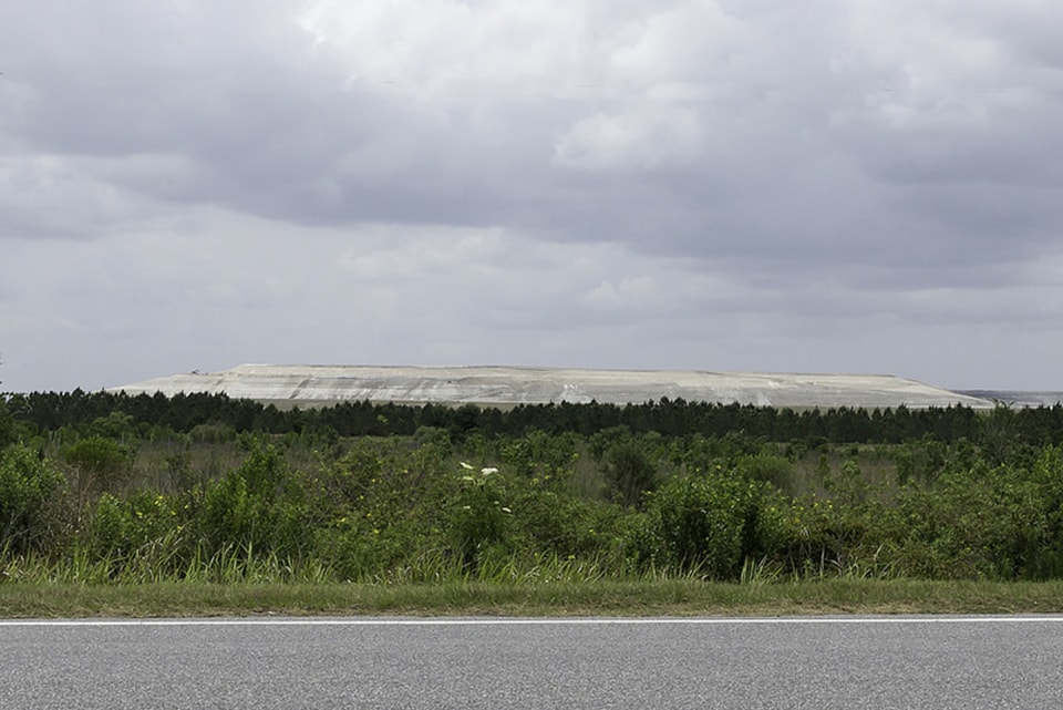
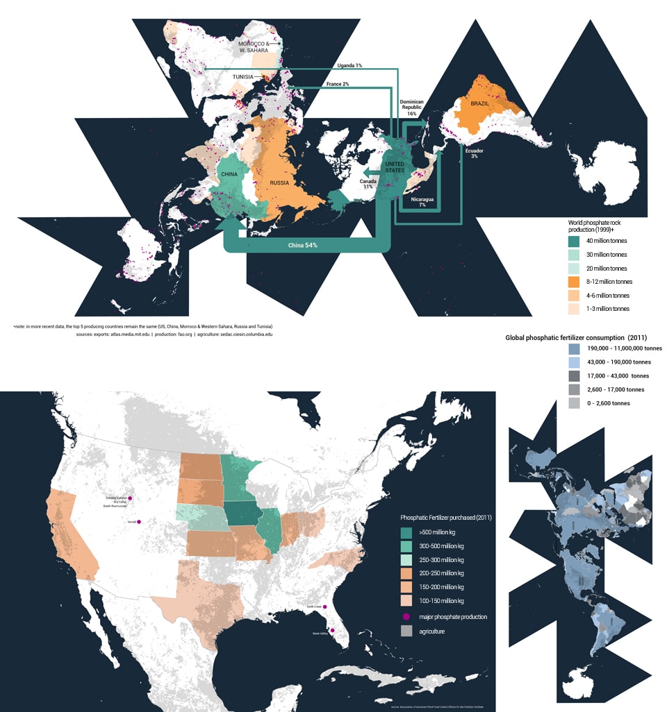
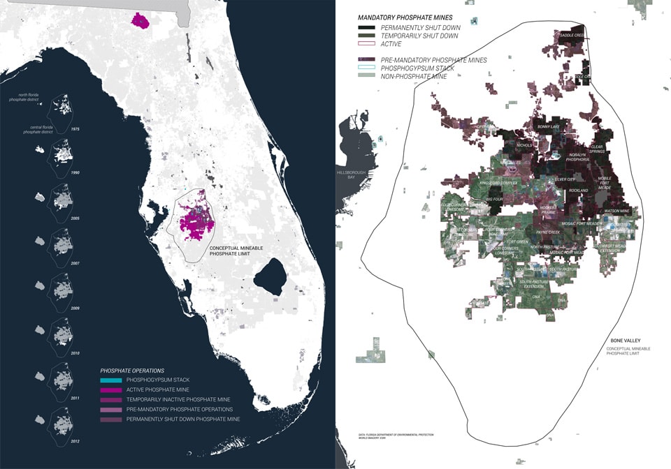
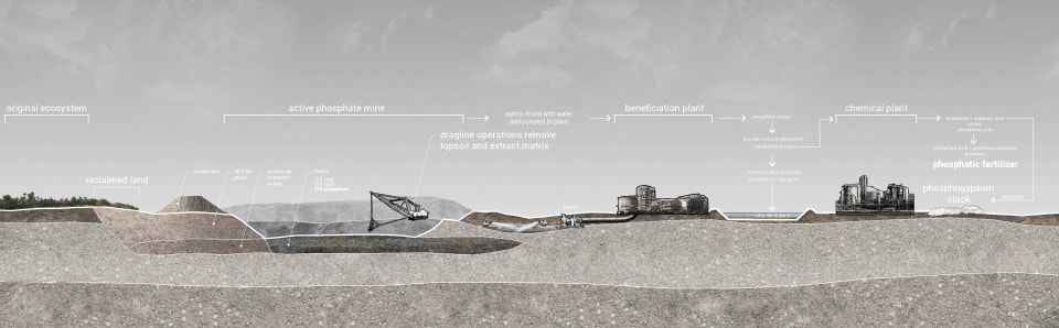
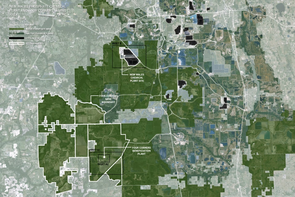
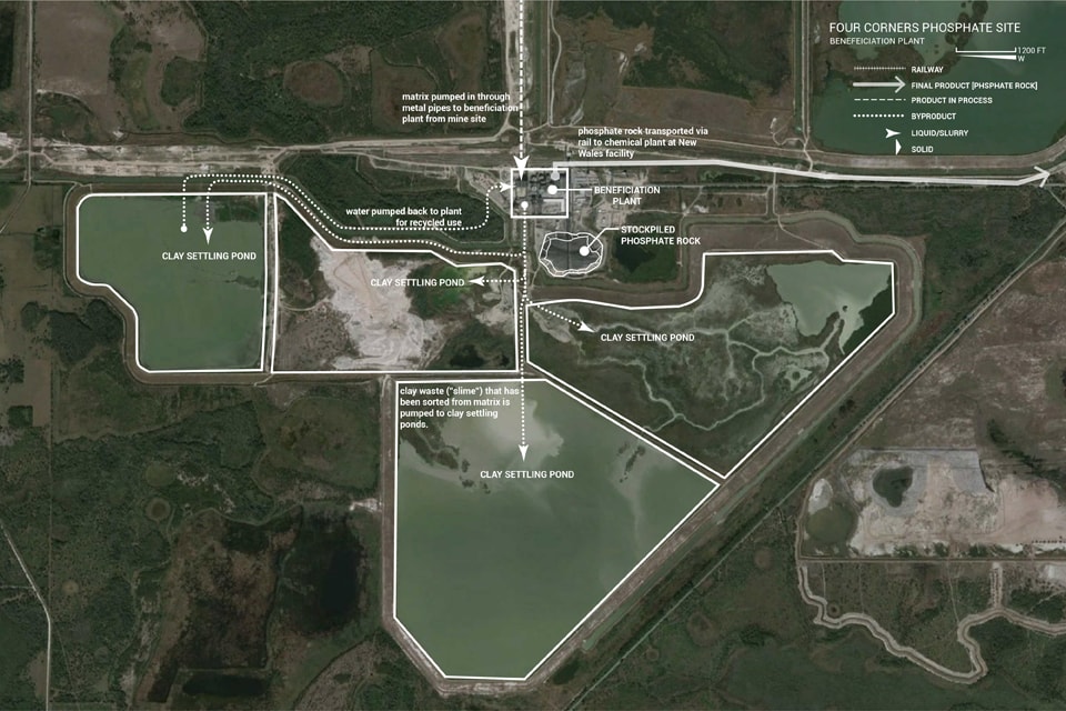
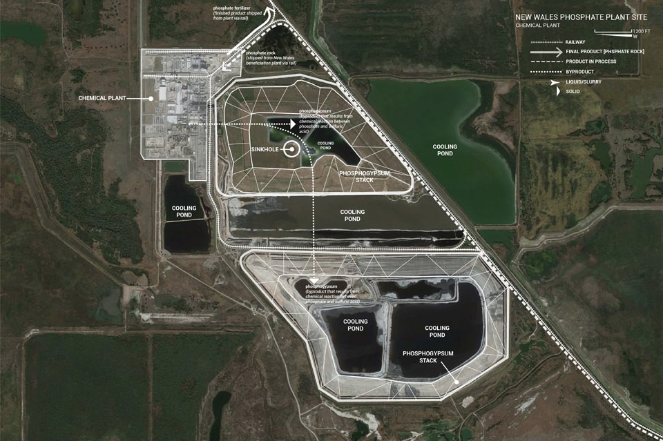
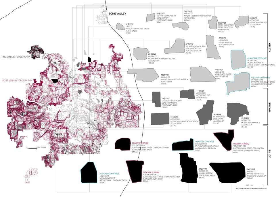
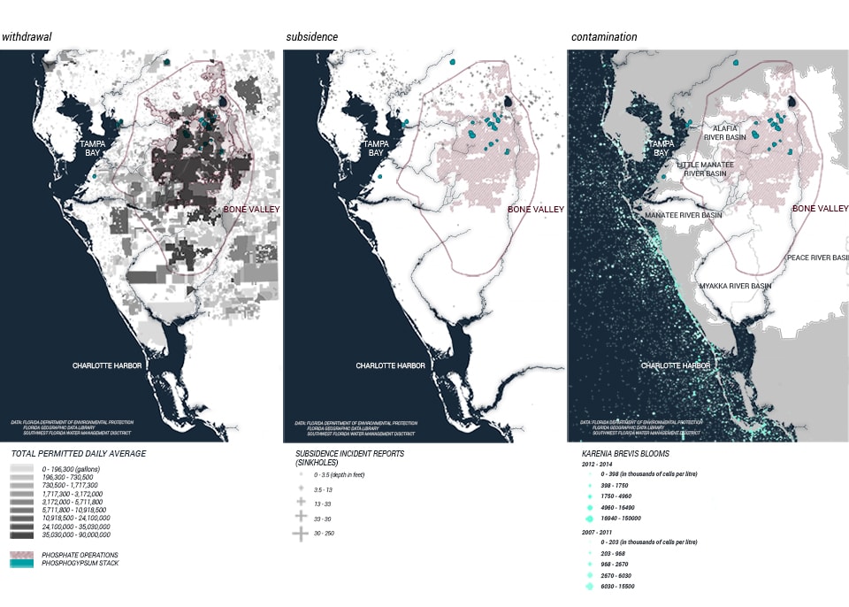
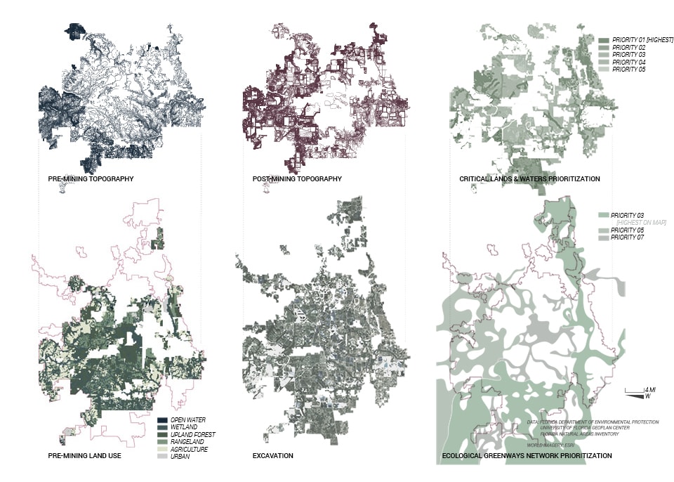
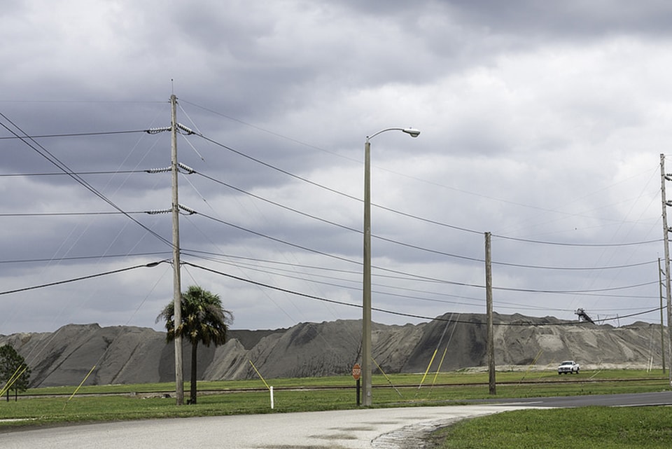
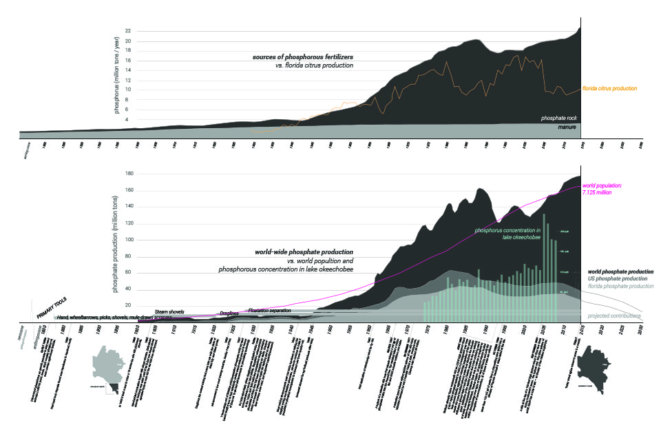
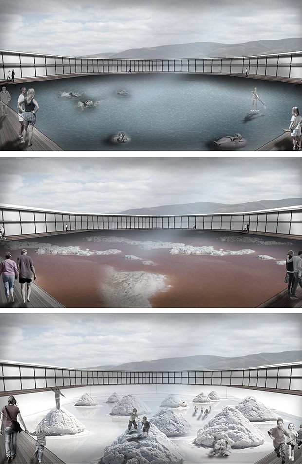
Exploring the accidental monuments of excavation, One Percent: Mining Bone Valley by Rob Holmes, Lauren Sosa and Christie Allen, investigates the enormous mounds caused by phosphate mining that dominate the landscape in Florida, where gypsum stacks grow endlessly in response to the voracious global appetite for phosphate. The mining of minerals below ground also calls into question the rights of others who might stake their own claims to the surface, dramatizing how mining privileges the ownership of the subterranean layer of the landscape at the expense of all others. In Contested Landscapes: Staking Claims in Michigan’s Copper Country, Elizabeth Yarina examines how a copper mine in Michigan has ignited a battle between competing groups who each find value in different layers of a vertical territory.

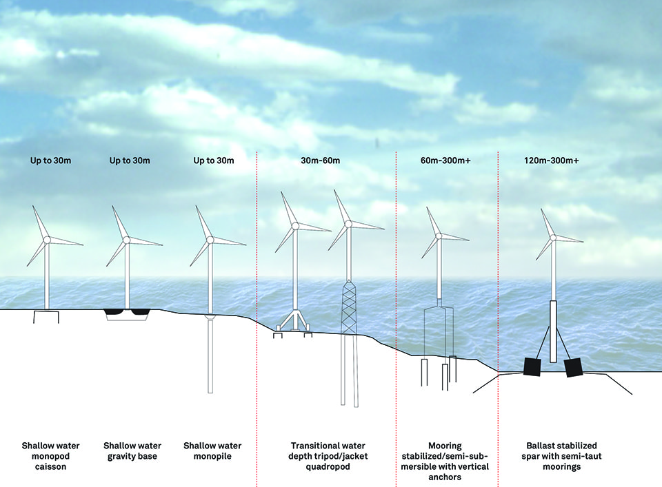
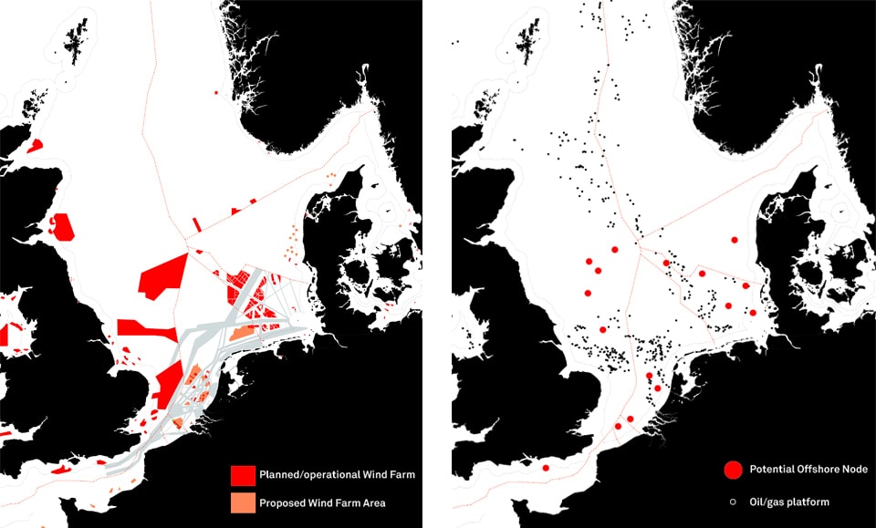
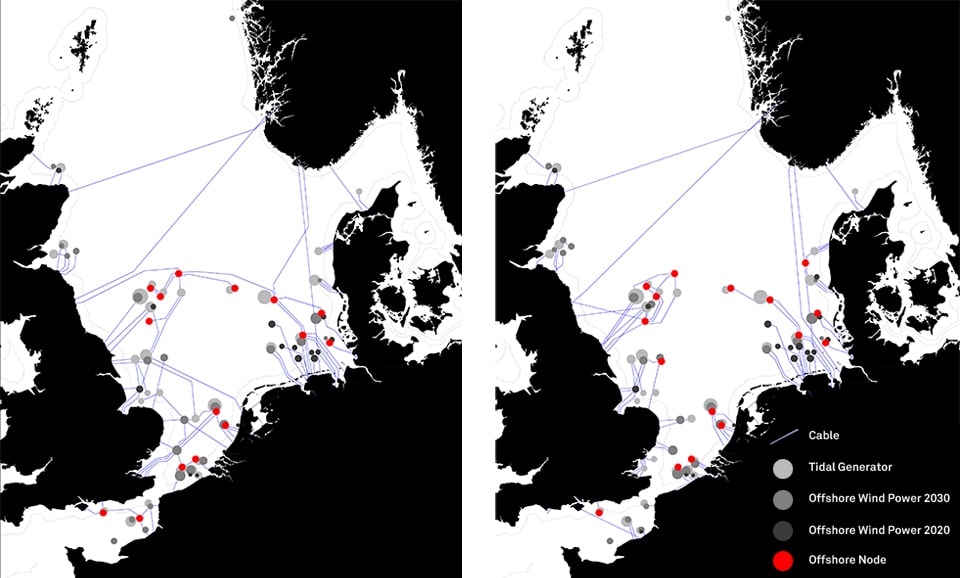
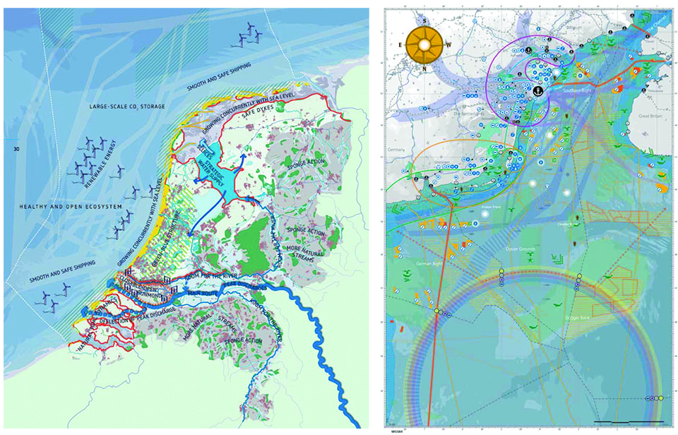
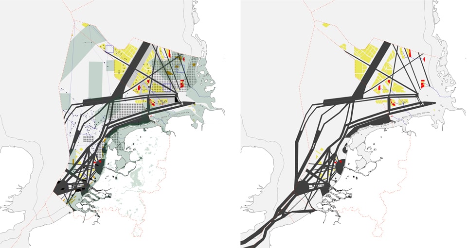
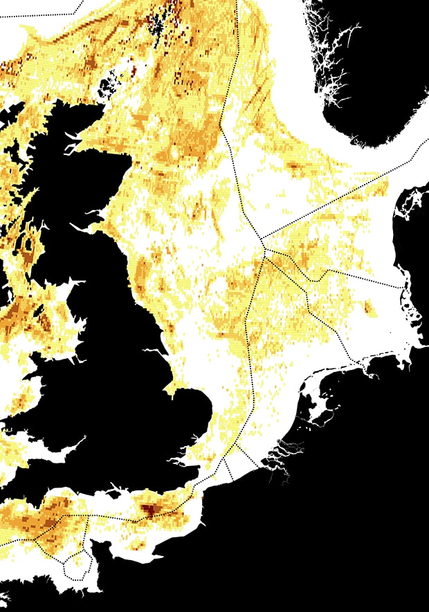
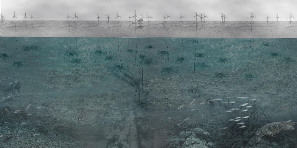
Invisible lines can shape landscapes of extraction. Jamie Vannichi’s Crossing the Line investigates the porous border between one state that bans natural gas extraction, and a neighboring one that actively allows it. Energy Extraction from Wind: Marine Re-Territorialization in the North Sea, Claudia Bode examines the articulation of lineages of spatial control of the seas through the mapping of immaterial phenomena such as fishing rights, wind resources, and international shipping. Matt Wiener, in Grounding Water, investigates the spatial and temporal difficulties of imaging groundwater, a substance often represented as static but which is in continuous motion, calling into question the effectiveness of traditional methods of representation.

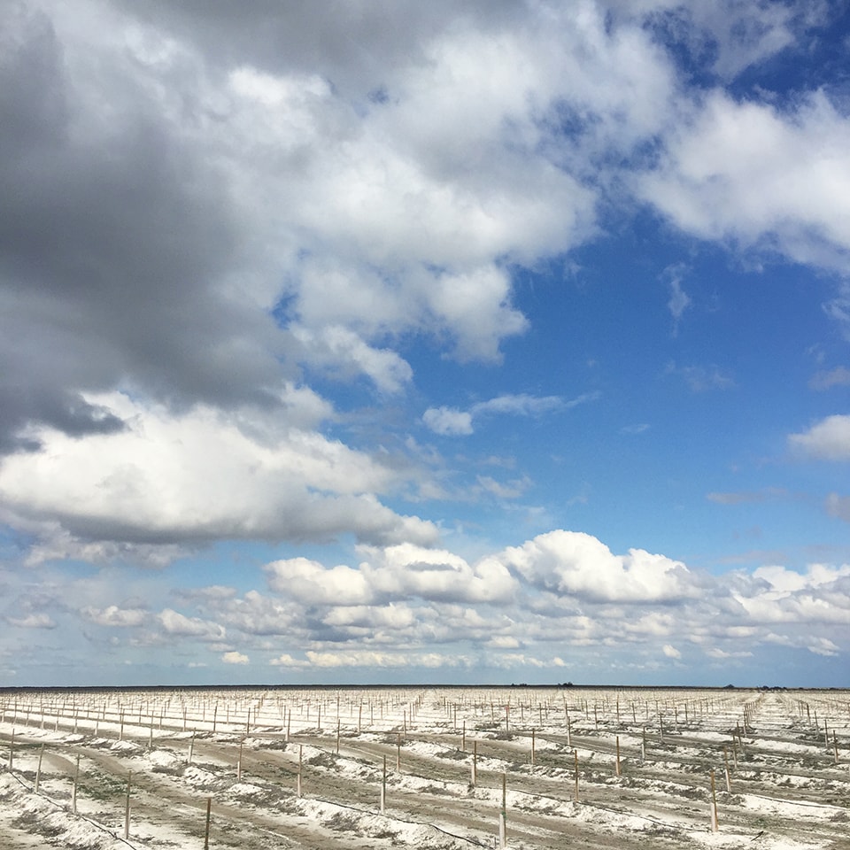
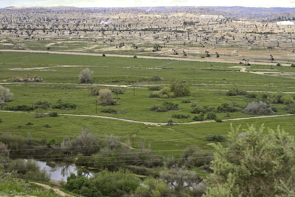
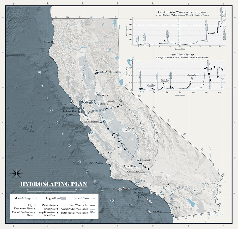
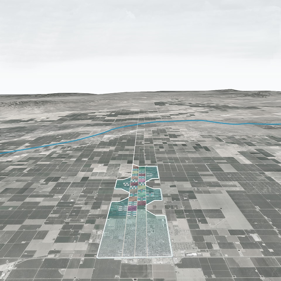
Large infrastructural projects upend and reorganize territory, setting in motion new patterns of use and new possibilities for settlement. In The Cheap Frontier: Operationalizing New Natures in the Central Valley, Neeraj Bhatia looks at California’s Central Valley as a completely invented infrastructural landscape: possessing good soils but little else, it has thoroughly transformed itself through the importation of water, technology, and people, and become fine-tuned for extracting maximum value from a thoroughly re-engineered nature.

Finally, in the Museum of Lost Volumes, Neyran Turan speculates on an alternate future where the prolific deployment of clean-energy technologies has resulted in the depletion of the world’s rare earth minerals, and the Zero-Carbon era has drawn to a close.

The pieces in this collection each grapple with a process and landscape of extraction, but each also goes beyond the outward appearances of the dramatic places that they describe. They tie together material and form with the underlying processes and flows that drive these massive landscape transformations. Extraction collectively represents humanity’s most drastic and lasting imprint upon the geological and ecological patterns of the Earth. By looking closely at these vast processes set into motion by seemingly disconnected activities in cities, towns, and industries far away, we aim to highlight the reciprocal nature of these paired landscapes, and to give designers, artists, planners, engineers, and urban citizens a spatial vocabulary for taking collective responsibility for the larger extraction landscape.


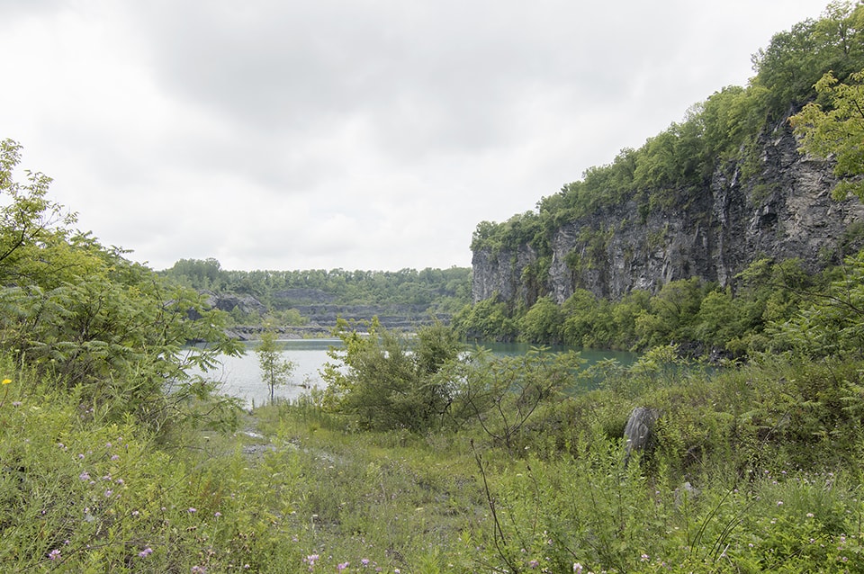
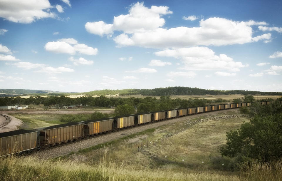
SCENARIO 5: Extraction Cover Image by Joseph Elliott

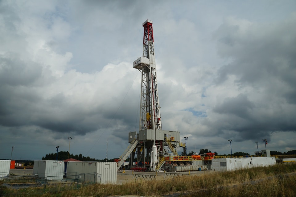
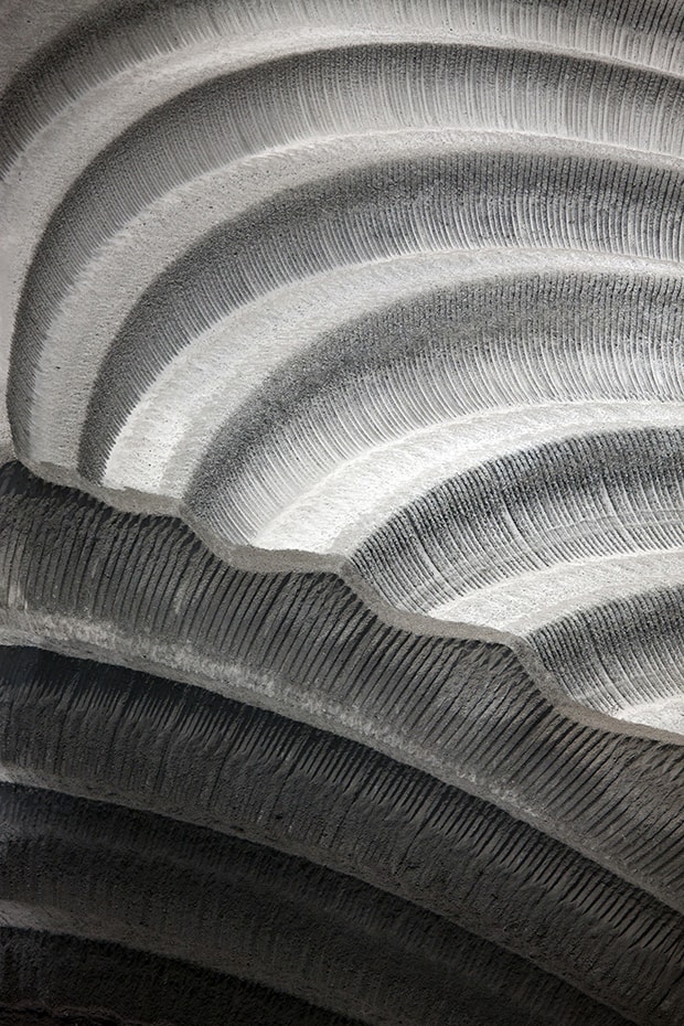
Table of Contents Header Image by Kees Wolthoorn

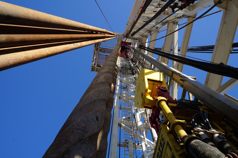
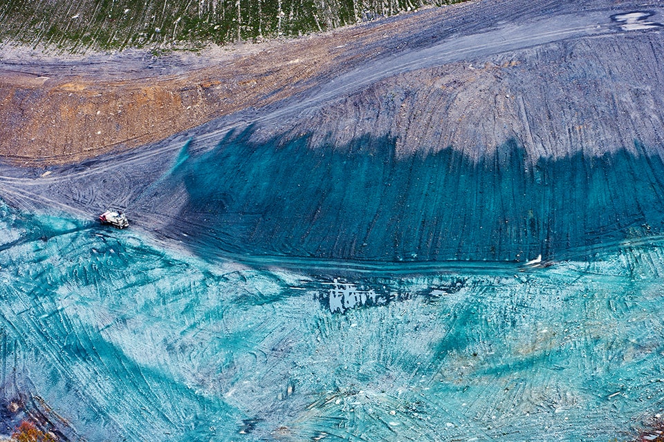
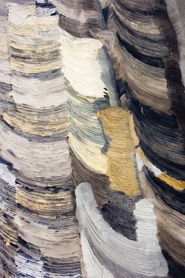
Feature image by Mathias Liebing


Stephanie Carlisle is a designer and environmental researcher whose work focuses on the relationship between the built and natural environment. She works in the research group at KieranTimberlake Architects. She is also a lecturer of Urban Ecology in the Department of Landscape Architecture and Regional Planning at the University of Pennsylvania School of Design. She is a co-editor of this issue.


NickPevznerNicholas Pevzner’s work explores the role that infrastructural landscape moves can play in structuring and sustaining healthy cities. He teaches in the Department of Landscape Architecture and Regional Planning at the University of Pennsylvania School of Design. He is a co-editor of this issue. 


Notes:

[1] Jane Hutton, “Reciprocal Landscapes: material portraits in New York City and elsewhere,” Journal of Landscape Architecture  8:1, 40-47, DOI: 10.1080/18626033.2013.798922.
[2] John Brinckerhoff Jackson, Discovering the Vernacular Landscape (New Haven and London: Yale University Press, 1984), 5.
[3] Lucy R. Lippard, Undermining: A Wild Ride Through Land Art, Politics, and Art in the Changing West (New York & London: The New Press, 2014),11.
[4] See Geoff Manaugh, ed., Landscape Futures: Instruments, Devices and Architectural Inventions (Barcelona and Reno: Actar/Nevada Museum of Art, 2012).
[5] Perversely, the first oil wells in Pennsylvania in the 1850s and ‘60s employed drilling rigs designed and built for drilling water wells.


Gold Mining Exploits And The Legacies Of Johannesburg’s Mining Landscapes

Mining activity is a deeply destructive process with consequences that continue to affect many industrial cities around the world. Hinged on extracting wealth and driving down costs to maximise profits, the direct impacts of the physical extraction of minerals and the more nuanced implications of the mining industry on society and the environment create a legacy of disturbance that is far more challenging than a radically altered landscape.

The Rand


JOHANNESBURG’S SCARRED LANDSCAPE

Few landscapes have seen mining activity on the scale at which it occurs in South Africa’s Gauteng City-Region (GCR). The majority of the GCR falls into the Gauteng Province, the most densely populated province of South Africa, supporting an estimated 12.2 million individuals [1]. The GCR is composed of a cluster of cities, towns, and urban nodes including Johannesburg and Pretoria. The GCR is also the site of the largest and deepest gold resources in the world [2], a natural asset that has enabled the city-region to become South Africa’s foremost economic engine. From 1970 onwards, gold mining in the GCR rapidly declined, and a shift to a service-oriented economy occurred. Gold mining still happens in Gauteng, and the province is home to the world’s two deepest mines, the Mponeng and TauTona gold mines owned by AngloGold Ashanti, that extend to depths of almost 4km below ground. Diamond, coal and platinum mining still takes place in the greater GCR.

Johannesburg is South Africa’s largest city and one of Africa’s leading urban economies. Situated at the heart of Gauteng, the ‘City of Gold’ has only existed since 1886, when gold was first discovered there. The city’s development was remarkable. Gold was initially found along a rocky outcrop, called the Witwatersrand (‘the ridge of white waters’) that extends in an east-west direction across the central GCR, also known as the ‘Rand’ [3]. The discovery of the world’s largest gold deposit attracted prospectors from all over the world and, within a matter of months, transformed the farmlands and open grass plains that fell along the Rand into a bustling mining town. From the outset, mining activity took place at a rapid rate. Financed by capital from the then declining Kimberly diamond fields, and other circuits of colonial capital, mining on the Rand not only extracted significant wealth from the ground but also instilled deep socio-economic and class divides.

City of ExtractionCity of Extraction

The continual extraction of gold and waste products, generated by increasingly deeper mining operations, has created a landscape that is strewn with large mounds of mine waste and slimes dams. Although mining activity adjacent to Johannesburg has ceased, this landscape of extraction awkwardly intercepts the city’s freeways, human settlements, and ecological systems. The blank zones that remain — created by pockets of uninhabitable mine waste — present challenges for the future development and spatial integration of the city-region.

Traces of Extraction

Traces of historic extraction awkwardly intercepts the city’s freeways, human settlements and ecological systems.


THE CONTEMPORARY LANDSCAPE

An extensive network of abandoned mine shafts and tunnels exist beneath Johannesburg. Today, these spaces are lost to time, and the equipment, signage, supports, and machinery have long been forgotten and abandoned below the surface of the Earth. Degrading slowly, the importance of these hidden subterranean voids have been replaced by the buzz of the city above.

Exploring Johannesburg as a cross section, running in a north-south direction, the city transforms from a landscape of old tree-lined suburbs, once shaped by wealthy mining masters, that frame decentralised economic nodes, to a concrete and vertical inner city defined by the old central business district. Further south, the inner city abuts the remnants of mining activity and is interspersed with light industry, manufacturing and warehouses. This collaged suburban landscape is intersected by the few remaining mine heads, mining outbuildings, mine waste, a prominent municipal rubbish dump and tall blue gum trees, the wood of which was used as props in the mines.

Processes of Extraction

Processes of Extraction: Landscapes of wealth and waste. Diagram depicts historic (1), and modern extraction processes (2) along the Rand

Diverse ecosystems, both natural and constructed, intercept the built urban form of the city, binding it to the surrounding natural network of flora, fauna, soil, water, and air. These essential infrastructures and resources support life in Johannesburg but are constantly threatened by the products of urban lifestyles, industry and mining. On the periphery of the city-region, many areas of great density suddenly emerge. Large apartheid township areas such as KwaThema, Katlehong, Ga-Rankuwa, Kagiso and Orange Farm are located away from social, cultural and economic centres. Dependent on various forms of unreliable public transport, residents of these satellite suburbs are distinctly spatially disadvantaged.

Landscapes of wealth and waste

Sites of wealth in the North, and waste in the South


PROCESSES OF EXTRACTION

Despite the social and environmental challenges embedded in a landscape polluted by mine waste, the City of Johannesburg would not exist without constant reinvestment of mining capital into its urban form and infrastructure. Town Planner Keith Beavon refers to the early fortunes, booms, slumps, and turnarounds of the SA economy due to gold production from 1886, until its eventual decline in the 1970s [4]. This economic uncertainty was the result of limitations on the production of gold, such as the fixed gold price, low gold grade, inefficient technology, and political instability. Despite these limitations, influential moments in the City of Johannesburg’s gold mining history associated with technological advances to extract gold from deeper belowground, the sourcing of cheap labour, and the securing of a sustainable water source, allowed for profitable mining to continue along the Rand, generating the necessary funds for the constant reinvestment of mining capital into its urban form and infrastructure.

The Rand yielded over 47,000 tonnes of gold between 1886 and 2002, which is also said to represent between 33% and 40% of all gold ever produced globally [5]. Mines kept their operational costs artificially low in order to overcome the unpredictable challenges associated with slim profit margins [6]. This was largely achieved by squeezing out excess costs through irresponsible mining methods, and externalising long-term costs into the hands of third parties wherever possible. As such, the early gold mining economy was reported to be a purely extractive industry with very little consideration for its long-term impacts [7].

For example, as gold mining activity continued along the Rand, mines had to dig deeper — an increasingly expensive exploit — to reach lower-grade gold. During the early years of gold production between 1886 — 1932, the price of gold was fixed on the international market, called the “Gold Standard.” Consequently, gold production costs were minimised through reducing operational and labour costs [8]. The desire to ensure a cheap labour force led to a new set of socially extractive and highly destructive forces for South Africa that manifested in the form of the infamous migrant labour system. Here, mines actively recruited labour from distant rural communities, trapping workers with highly exploitative contracts and working conditions that dramatically limited their freedoms.

The environment itself was also available for easy exploitation. Due to the low grade of gold on the Rand, it is estimated that approximately one ton of ore was extracted from the Earth for every 3 grams of gold produced [9]. Extraction of gold at this grade was simply not financially viable in other parts of the world [10]. Similarly, the vast amount of flat, open space surrounding Johannesburg allowed mine waste to be dumped easily and with limited regard to surrounding ecosystems. Today, a traceable belt of mine waste runs along the 400km-long gold-bearing reef, marking the sites of past extraction.

Mining Waste BeltJohannesburg’s mining waste belt


EXTERNALITIES OF AN EXTRACTIVE PROCESS

Mining companies prior to 1991 placed little consideration on their effects on society and the environment [11]. As former mines became unprofitable and were abandoned, mine waste was often left untreated and damaged landscapes un-rehabilitated. Compounded by weak legislation and loopholes, mining companies were able to turn a blind eye to their mining waste responsibilities, leaving behind liabilities that have only become visible long after mining operations have ceased [12]. Mine waste now lies scattered across the city of Johannesburg and its hinterland, polluting common pool resources such as air and water, posing risks to humans and the environment on a daily basis [13]. This, unfortunately, is only a glimpse of South Africa’s mine waste inheritance. It is estimated that across its nine provinces, South Africa has inherited 6,000 ownerless and derelict mines that will cost approximately R30 billion to maintain and rehabilitate [14].

Legacy of extraction

The legacy of extraction still impacts those living adjacent to mine waste

Gold waste produced before 1952 contains elevated levels of uranium, a naturally occurring radioactive metal found along the Rand. Prior to this time, the gold extraction process did not remove uranium found in mined ore and this has subsequently led to contamination through the leaching of uranium from mine waste into the surrounding environment [15]. The lasting consequences of the extraction process still impact the lives of those that live adjacent to mine waste. The health effects of inhaled radioactive particles from mine waste are reported to create toxic effects in the lungs of humans and can be absorbed into the body, leading to radiotoxicity [16].

Proximity of settlements to mine waste

The close proximity of human settlements to mine waste

While the intricate hydrological system along the Rand can offset localized effects of mine waste on society and the environment by diluting the concentration of contaminants leached from mine waste deposits, it is not sufficient to deal with the full environmental impact of mine waste. In 2002, acidic underground mine water, known as acid mine drainage (AMD) rose to the surface in the western part of Johannesburg and decanted into the natural hydrological system [17]. The increased occurrence of heavy metals and the high acidity of AMD exceeded the natural buffering capabilities of the hydrological system and have left lasting impacts on the environment. The government has put measures in place to partially treat AMD after pumping contaminated water from the underground mine void instead of allowing it to decant on the surface. However, water released into the environment is still heavily loaded with salt, contributing to the increased salinity of watercourses and the broader hydrological network. Until a more sustainable long-term intervention is devised, partially treated AMD is mixed with water earmarked for domestic and industrial use. Due to the limited availability of water in the GCR, this has placed increasing concern on the water security of the region. Similar environmental thresholds have been breached in local ponds and lakes that fall along the Rand that were used as local storage sites for contaminated mine waste. These areas, once considered to be oases along the Rand, have now become sterile landscapes that can support no life [18].


REWORKING OLD SITES OF EXTRACTION

As gold mining in Gauteng reaches the end of its lifespan, the new face of active mining in the province lies in the extraction of diamonds, coal and platinum. As a way to address the extractive legacies of the gold mining industry, initiatives have been put in place to bring new life to old sites of extraction.

Present-day gold re-mining activities along the Rand reprocess mine waste to extract further profits from the now-expired mining industry and serve revived sites of extraction. For example, a mining company located on Gauteng’s West Rand has bought rights to the waste deposits of historic gold mines in order to reclaim fragments of gold that remain in mine waste deposits. While doing so, they rehabilitate the remaining land after reclamation and prepare it for re-development. Such ventures are undertaken primarily by the private sector through a small number of developers who work these territories for their own profit. These projects not only transform the physical landscape, but have also begun to alter the incurable relationship that exists between mining houses and the public sector.

Government funding and expertise has also been directed towards the development of alternative futures for the city-region. One example is the Gauteng Department of Agricultural and Rural Development’s programme for reclaiming and rehabilitating mine waste landscapes. This programme aims to reclaim Gauteng’s mining waste landscapes as way to preserve the natural functioning of the environment and create new land for housing, food production and the cultivation of biofuel crops or flowers [19]. Another example is the coordinated effort of the South African National Department of Mineral Resources, which has allocated additional funds to rehabilitate 50 ownerless and derelict mines annually from 2014 to 2018 [20].

While alternative visions for past sites of extraction aim to provide a basis for continued intervention and the creation of improved future landscapes, there is often a lack of political will to bring about true change in the public sector, and attempts at true remediation by both the public and private sector are limited. Other fundamental challenges include the costs associated with transforming these spaces for the long term, which creates a fundamental constraint for private sector investment.


CONCLUSION

Landscapes that support natural and constructed ecosystems are much wiser counterparts to landscapes of wealth and waste created by mining. The legacies of extraction have fundamentally shaped parts of Johannesburg’s landscape, society, and ecological systems. The scale and importance of mining on the Rand for the South African economy is considerable, and as such, mining capital has had a direct hand in influencing urban development and growth in other parts of South Africa. Mining capital has also undoubtedly played a radical role in shaping society along racial lines in the city’s early years, which has evolved today into distinct economic divides. This, together with the legacy of apartheid planning, has fragmented Johannesburg’s urban form, distorting the natural landscape, and creating insurmountable barriers to spatial integration, while the mismanagement of waste landscapes has led to environmental disaster in many areas.

Legacies of extraction


Restoring life to the blank zones created by mining waste is critical to achieving a liveable and equitable future city-region. Unless these extractive legacies are addressed, they will remain as obstacles to the city’s urban and social development, creating more intense and compounded legacies for generations to come. Understanding the complex three-dimensional urban ecologies and forces that have guided the extraction process are essential for building alternative futures in these forgotten landscapes.


Guy Trangos

Guy Trangoš  is a professional architect, writer and academic. He is a researcher at the Gauteng City-Region Observatory (GCRO), an organisation established to research the urban complexities of the Gauteng City-Region. The GCRO is a partnership between Gauteng Provincial Government, the University of the Witwatersrand (Wits), the University of Johannesburg and local government, South Africa.

Guy has practiced at both Mashabane Rose Architects and 26’10 south Architects. Today, Guy writes on architecture and urbanism for various publications. His research is centred on changing urban publics, urban mobility, urban design and information design. He holds a MArch (Prof) (Wits), and a MSc City Design and Social Science (LSE). 

Kerry BobbinsKerry Bobbins is a researcher at the Gauteng City-Region Observatory, a partnership between the University of Johannesburg, the University of the Witwatersrand, Gauteng Provincial Government, and organised local government, South Africa. She graduated from Rhodes University, South Africa, with an MSc in Physical Geography and has completed additional Masters’ courses in International Environmental Policy and Environment and Development from Wageningen University in the Netherlands. Kerry’s research interests include the valuation of environmental infrastructure in urban and non-urban landscapes, provisioning of ecosystem goods and services, water governance and policy, mining impacts on the environment and landscape restoration.


Notes

[1] Statistics South Africa (StatsSA), Census 2011, Pretoria: Statistics South Africa, 2011.
[2] Gauteng Department of Agriculture Conservation and the Environment (GDACE), Mining and environmental impact guide (Johannesburg: GDACE, 2008), accessed January 16, 2015, http://www.gdard.gpg.gov.za/Documents1/MiningandEnvironmentalImpactGuide.pdf
[3] Keith Beavon, “The Foundation Years: From Mining Camp to major City 1886 – 1900,” In Johannesburg: the Making and Shaping of the City, edited by Keith Beavon, 17 -117. Leiden: Koninklijke Brill, 2004.
[4] Keith Beavon, “The Foundation Years: From Mining Camp to major City 1886 – 1900,” In Johannesburg: the Making and Shaping of the City, edited by Keith Beavon, 17 -117. Leiden: Koninklijke Brill, 2004.
[5] Gauteng Department of Agriculture Conservation and the Environment (GDACE), Mining and environmental impact guide (Johannesburg: GDACE, 2008), accessed January 16, 2015, http://www.gdard.gpg.gov.za/Documents1/MiningandEnvironmentalImpactGuide.pdf
[6] Rebecca A. Adler, Marius Claassen, Linda Godfrey and Anthony R. Turton, “Water, mining and waste: an historical economic perspective on conflict management in South Africa,” The Economics of Peace and Security Journal, 2 (2007): 32-41.
[7] Rebecca A. Adler, Marius Claassen, Linda Godfrey and Anthony R. Turton, “Water, mining and waste: an historical economic perspective on conflict management in South Africa,” The Economics of Peace and Security Journal, 2 (2007): 32-41.
[8] South African History Online. “The Glitter of Gold.” Accessed January 12, 2015, http://www.sahistory.org.za/archive/glitter-gold.
[9] South African History Online. “The Glitter of Gold.” Accessed January 12, 2015, http://www.sahistory.org.za/archive/glitter-gold.
[10] Frank Winde, Peter Wade and Izak J. van der Walt, “Gold tailing as a source of waterborne uranium contamination of streams – the Koekemoerspruit (Part I of III),” Water South Africa, 30 (2004): 219 – 225.
[11] Elize Swart, “The South African Legislative Framework for Mine Closure,” The Journal of the South African Institute of Mining and Metallurgy (2003): 489-492.
[12] Rebecca A. Adler, Marius Claassen, Linda Godfrey and Anthony R. Turton, “Water, mining and waste: an historical economic perspective on conflict management in South Africa,” The Economics of Peace and Security Journal, 2 (2007): 32-41.
[13] Elize Swart, “The South African Legislative Framework for Mine Closure,” The Journal of the South African Institute of Mining and Metallurgy (2003): 489-492.
[14] World Wildlife Fund (WWF) South Africa, Financial provisions for rehabilitation and closure in South Africa Mining: discussion document in challenges and recommended improvements (summary) (Cape Town: SA: WWF-World Wide Fund, 2012), accessed January 12, 2015, http://awsassets.wwf.org.za/downloads/wwf_mining_8_august_low_res.pdf.
[15] Frank Winde, Peter Wade and Izak J. van der Walt, “Gold tailing as a source of waterborne uranium contamination of streams – the Koekemoerspruit (Part I of III),” Water South Africa, 30 (2004): 219 – 225.
[16] Mariette Liefferink, “Radiological hazards/risks and regulatory capacity constraints pertaining to radioactive waste: uranium mining” (online presentation). The Federation for a Sustainable Environment, 2013, accessed January 12, 2015, http://www.doe-irp.co.za/irpJHB/FEDERATION_SUSTAINABLE_ENVIRONMENT.pdf.
[17] Expert team of the Inter-Ministerial Committee, Mine water management in the Witwatersrand Gold Fields with special emphasis on acid mine drainage. Report to the Inter-Ministerial Committee on Acid Mine Drainage. (Pretoria: Department of Water Affairs, 2010), accessed January 12, 2015, https://www.dwaf.gov.za/Documents/ACIDReport.pdf.
[18] Rand Water, “Water Quality and Pollution FAQ: How does mining contribute to water pollution in South Africa?.” Rand Water, 2015, accessed January 12, 2015, http://www.waterwise.co.za/site/water/faq/pollution.html.
[19] Gauteng Department of Agricultural and Rural Development (GDARD), Study on Reclamation and Rehabilitation of mine residue areas for development purposes: Phase 1 Strategy and implementation plan (Johannesburg: GDARD, 2012), accessed January 16, 2015, http://www.gdard.gpg.gov.za/Services1/Reclamation and Rehabilitation of Mine Residue Areas Strategy”.pdf.
[20] South African Department of National Treasury (DNT), 2015 Estimates of National Expenditure. (Pretoria: National Treasury, 2015), accessed April 20, 2015, http://www.treasury.gov.za/documents/national budget/2015/ene/FullENE.pdf.

Pit And Quarry: The Cement And Slate Landscapes Of Pennsylvania

Among the oldest of technologies, the extractive industries involve the removal and processing of raw materials from the earth and their global scale of operation has transformed entire regions and markets. The Lehigh Valley in southeastern Pennsylvania gave rise to several world-class extractive industries, including steel and cement production, coal mining, and slate quarrying, all of which would dominate the American and international scene by the first decade of the twentieth century.

As Sir Neil Cossons has keenly observed, “the world came of age in the twentieth century [;] a century endowed at its outset with immense industrial power, widespread prosperity, and emerging technologies that were to affect the lives of every person on the planet” [1]. The Lehigh Valley’s cement and slate industries were no exception, and their success created a much altered landscape with vast and deep quarries, enormous kilns, and mill buildings. These places, the intersection of geology, technology, and culture, were an important part of American life and their stories are still accessible through the visual testimony of the land, the structures, and the machinery, as well as the stories of those who last labored there. Many such sites, rich in historical value, are also environmental brownfields, making them doubly important as landscapes of remediation. They are part of a complex landscape that now demands consideration of its latent architectural, ecological, and socio-cultural assets.

01_Slate Quarry_J Elliott

Slate Quarry, Slatedale, PA, 2000. Photo by Joseph Elliott


2013 marked the 50th anniversary of Kenneth Hudson’s groundbreaking book and manifesto on “industrial archaeology,” the “mongrel” field he first named as the bastard offspring of industry and archaeology [2]. Today the remains of industry past dominate the global landscape. Urban and rural America are littered with the evidence of the last two centuries of the country’s former industrial prowess and many of these places, now abandoned, hold latent value for their transformation and reuse. Since Lawrence Halprin’s 1967 conversion of Ghirardelli Chocolate Company’s headquarters to public retail and Richard Haag’s 1971-1976 Gasland Park in Seattle, myriad other examples [3] in the U.S. have since followed. Recent initiatives such as the Industrial Heritage Reuse Project by the Preservation League of New York State are specifically examining the reuse potential of several abandoned industrial buildings in Albany to provide model approaches in similar urban contexts elsewhere. But many other less adaptable sites such as brick yards, cement plants, and quarries of landscape scale, pose enormous difficulties for preservation and reuse.

Despite the recent popularity of industrial chic, critics now question whether this form of “adhocism” — that is, the improvisation of new, unrelated uses devoid of meaning and interpretation — has led to, at best, a polite taming of industrial heritage, and, at worst, its grotesque disfigurement in the name of gentrification and short-sighted corporate marketing. A shift in thinking is now required for more sustainable preservation: thematic approaches that examine the problems and potential based on the original industrial processes; consideration and interventions at the landscape scale, ecological as well as architectural thinking, and finally, human connections through past and current associations.

02_Slate Hoists_J Elliott

Slate Hoists, Penn Argyl PA, 2010. Photo by Joseph Elliott


Slate World

The Pennsylvania “Slate Belt,” an area of only 22 square miles, lies approximately 50 miles to the northwest of Philadelphia and just south of Blue (Kittanning) Mountain between the Delaware and Lehigh Rivers. The first quarries opened in the 1830s, but significant growth followed in the first decade of the twentieth century when Lehigh Valley accounted for approximately half the slate produced in the United States, eventually becoming the greatest slate producing region in the world [4]. During World War I, many of the slate firms closed to release men for other essential war work, especially in the Bethlehem Steel plant nearby. Most of the quarries never reopened after the war as modern synthetic materials such as asphalt composites and plastics proved less expensive and easier to use, and required less skilled labor to fabricate and install.

Wall of idled American Bangor slate quarry showing enormous bore holes.

American Bangor Slate Quarry, 2015. Photo by Preston Hull


The masts for the slate hoists of the Penn Big Bed slate company.

Penn Big Bed Slate Hoist Masts, 2015. Photo by Preston Hull


Today only a handful of the old slate quarries remain active. Big Bed Slate, still in operation, is one of the oldest and best preserved of the early operations with its iron crane hoists, steam and electric machinery and mill shops, and extensive series of former and active quarries. This company, still economically viable, and interested in spearheading a reinterpretation of the valley’s industrial history, offers a unique opportunity together with the Slate Belt Heritage Center in Bangor, PA to document that legacy through a creative mix of preservation and economic development.

Hercules (now Buzzi Unicem) office building with plant structure in background.

Hercules Cement Company, 2015. Photo by Preston Hull


Cement Age

Reinforced concrete would prove to be the modern material of the new century and in the United States, the creation of the first Portland cement plants in the Lehigh Valley in 1871 at Coplay, would give rise to an industry that would forever change the face of America and the world [5]. An essential component of concrete, Portland cement is second only to water as the most consumed material on the planet. By 1901, the Atlas Portland Cement Co. in Northampton, PA was the largest cement company in the United States – more than twice the size and probably five to ten times the size of most firms in the industry. Cement consumption increased almost ten-fold from 1890 to 1913 and until 1907, more than half of the Portland cement produced in the United States came from the Lehigh Valley. Today the valley is still the country’s center of cement production but automation has rendered the old plants nearly vacant, their historic mills and kilns, though still impressive, largely abandoned.

Extensive ruins of the National Portland Cement Company, now a transfer station for East Penn Sanitation.

National Portland Cement, 2015. Photo by Preston Hull


07_Ranger Lake

Ranger Lake (former Lehigh Portland Cement quarry), Ormrod, PA 2014.
Photo by Joseph Elliott


Industrial Archaeology

Why invest in preserving these former industrial landscapes? The industrial legacy of Pennsylvania’s cement and slate belt holds the key to revitalization of the region by “regeneration through heritage,” not only in the preservation and possible re-use of these sites, but as catalysts for reviving and maintaining the social and cultural fabric of their surrounding communities and reclamation of the natural environment. First, their continued physical existence is critical to understand how the region took shape physically, socially, economically, and culturally, more than any text or photograph can convey: real structures in real landscapes. Second, these early twentieth century sites extend the region and country’s industrial narrative from the classic eighteenth and nineteenth century notion of industrial heritage to those complexes that were responsible for America’s emergence as the world power by the latter twentieth century. Third, although the twentieth century is better documented than any other century in word and image, analog and digital, the industrial artifact and place, where they survive together, still remain the primary locus for analysis and interpretation. Cultural and environmental conservation become powerful partners in reclaiming this complex place through ecological and social, as well as architectural and technological concerns. By taking a cultural landscape approach to the analysis and redevelopment of these overlapping industries, we acknowledge their original premise of natural resource extraction and exploitation in the deconstruction and re-construction of the land.

View of Lafarge's Cementon quarry, flooded and only worked minimally each year.

LafargeHolcim (Whitehall), 2015. Photo by Preston Hull


Grain mill incorporates the silos of the former National / Alpha mill just south of Martin's Creek on PA 611.

Alpha Cement Silos, 2015. Photo by Preston Hull


10_Lafage

Lafarge Cement, (former Whitehall Cement Co.), Cementon PA, 2014.
Photo by Joseph Elliott


Research for this essay comes from a recently launched PennPraxis project at the University of Pennsylvania, School of Design, focused on the extractive industries. It is funded by the J. M. Kaplan Fund and directed by Frank Matero, Professor of Architecture and Historic Preservation, and aims to bring a more critical approach to the identification, evaluation, and preservation of the most important and neglected of American industrial sites. Acknowledgements to Joseph Elliott, Preston Hull and Amy Lambert for their contributions.


MateroFrank G. Matero is Professor of Architecture and former Chair of the Graduate Program in Historic Preservation at the School of Design at the University of Pennsylvania. He is Director and founder of the Architectural Conservation Laboratory and a member of the Graduate Group in the Department of Art History and Research Associate of the University Museum of Archaeology and Anthropology. He was previously on faculty at the Graduate School of Architecture, Planning, and Preservation of Columbia University and guest lecturer at the International Center for the Study of Preservation and the Restoration of Cultural Property (ICCROM) in Rome, as well as lecturer at the Polytechnic University of Puerto Rico. He received his graduate degrees in architecture at Columbia University and in conservation at the Institute of Fine Arts, New York University. He is a Professional Associate of the American Institute for Conservation of Historic and Artistic Works and former Co-chair of the Research and Technical Studies Group and on editorial boards of The Getty Conservation Institute, the Journal of Architectural Conservation, and Cultural Resource Management. Currently he is editor-in-chief of Change Over Time, a new international journal on conservation and the built environment published by Penn Press.


Notes:

[1] Stratton, M. and B. Trinder 2000. Twentieth Century Industrial Archaeology. New York: E & FN Spon, vii.
[2] Hudson, K. 1963. Industrial Archaeology: An Introduction. London: J.Baker.
[3] These examples of conversion were driven in part by building booms in the 1970s and 80s, as well as by historic rehabilitation tax credits stemming from the Tax Reform Act of 1976.
[4] Dale, N. 1914. Slate in the United States. Washington, DC: U.S. Government Printing Office.
[5] Lesley, R. 1924. History of the Portland Cement Industry in the United States. Chicago: International Trade Press.


Butte Montana: A Case For The Mining Metropolis

“…and here was a scene so dreadfully hideous, so intolerably bleak and forlorn that it reduced the whole aspiration of man to a macabre and depressing joke. Here was wealth beyond computation, almost beyond imagination — and here were human habitations so abominable that they would have disgraced a race of alley cats.” [1]

– H. L. Mencken, The Libido for the Ugly


Simply put, extraction is an ugly process; both in physical form and its metropolitan externalities. Still, the vast resources present beneath us and the motivation to pull them to the surface are intimately tied to the settlement and permanent occupation of the landscape. At the start of the 20th century, the conditions H. L. Mencken describes were typical for many extraction-based mining towns and industrial regions around the country, although he did state that this particular instance in Pennsylvania was the ugliest place on earth he had ever seen. In many ways the physical conditions in the mining town of Butte, Montana at the time were likely not much better. There are few examples anywhere else in the world that showcase the collision of unimaginable wealth and the metropolitan implications of mass extraction better than Butte.

01_Butte 1900

Figure 1. Famous “Anaconda Hill,” showing mines of the Parrot lode, the scene of early-day mining. (Butte Silver-Bow Public Library)


Butte, America, as it was known by many residents, was a world-renowned destination for mining, located in western Montana at approximately 5,538 ft. above sea level, atop the Boulder Batholith. The copper and gold veining which cross the Butte district in an east-west manner are contained within this host rock. These veins are the product of geologic processes along the Northern Rocky fault lines that generated an ore body that is 25 miles wide and 70 miles long and extends deep into the earth [2]. The ore veins of the region can stretch over 12,000 feet, have a vertical continuity of over 4,500 feet, and have mining widths approaching 50 feet. The subsurface resources available within the Butte Mining District have yet to be exhausted, and allow Butte to be still called the “Richest Hill on Earth” [3]. It is this richness and depth of resources that contributed to the construction of a complex network of shaft mines that extend over a mile deep to reach the ore. Approximately 49 miles of vertical shafts and 10,000 miles of horizontal workings exist under the Butte Hill (including much of the historic uptown) as miners followed the veins of valuable materials prior to the conversion to open pit mining [4]. It was the existence of this vast mineral resource, in this particular place of the intermountain west in the late 1800s, that set the stage for Butte to become the extraction metropolis par excellence.


Myth of Mining

From the earliest days of mining in Butte, the enormity of both the resources and the processes conceived to extract them, had a range of transformative impacts on the surrounding region. The drive to fuel smelters and shore up mine shafts had removed every combustible stick in the valley. The rampant deforestation was further exacerbated by the total botanic suppression caused by air pollution from the smelters and the deposition of inhospitable waste rock strewn across the Butte Hill. By 1900, the rocky landscape of the Silver Bow Creek Valley had become barren, riddled with heaps and holes, and stained by air and water that teemed with an array of toxic metals.

This relationship between mining and the surrounding landscape has been a topic of discussion for as long as mining has been an organized industry. In 1556 Georgius Agricola released De Re Metallica, the most comprehensive how-to guide for locating, mining, assaying, and processing of metals ever written. In this text, Agricola addresses many of the challenges associated with the mining of metals and methodically refutes any and all critique of the process. When discussing the role of mining in transforming the landscape, the text remarks:

[A]s the miners dig almost exclusively in mountains otherwise unproductive, and in valleys invested in gloom, they do either slight damage to the fields or none at all. Lastly, where woods and glades are cut down, they may be sown with grain after they have been cleared from the roots of shrubs and trees. These new fields soon produce rich crops, so that they repair the losses which the inhabitants suffer from increased cost of timber. Moreover, with the metals which are melted from the ore, birds without number, edible beasts and fish can be purchased elsewhere and brought to these mountainous regions. [5]


02_DeReMetallica

Figure 2. Plate from Book 9 of De Re Metallica. (Project Gutenberg)


The intricate woodcuts produced for the volume show landscapes sprinkled with cottages, trees, and distant mountains. A figure from Book 9 (fig. 2) shows a process of smelting ore with the wind both helping to stoke the fire and also cleanly ‘sweeping away’ the resultant toxic smoke. A quick comparison with photos of Butte suggest a different story (fig. 3). The idealistic relationship between mining and the surficial landscape that Agricola describes did not exist in practice. For here in Butte we see a rather less romantic young child whose playground is a waste rock pile draped in a thick smog from the 24-hour processing of metal.

03_Neversweat 1900

Figure 3. Neversweat Mine – Butte, Montana 1900. (Butte Silver-Bow Public Library)


Work and Wealth

At the turn of the century, it was the presence of valuable metals and the intensity of geologic extraction alone that encouraged settlement in this remote location. Settlers came to the region looking to “strike it rich” through mining. This idea of instant fortune through mining marked a profound turn in labor. In Technics and Civilization, Lewis Mumford describes the transition from forms of labor such as farming or herding, to that of mining and industry. In the case of the former, there was a proportional relationship between labor and profit, where the drive to cultivate additional crops or raise larger herds of livestock translated into more work, but more pay. In the early years of mining, neither technical skill nor great effort was required for a miner to reap great fortune. Luck appeared to be the primary decider of profit [6]. The lifestyle and culture supported by such rich mining communities — highly competitive, lucrative, and employing high percentages of the population — had a significant and formative impact on the towns themselves. Mumford describes what he calls the “slatternly disorder” of the mining town as a product of the brutalizing conditions in which the miners worked. It could be assumed that in addition to the working conditions of the miners, the underlying possibility of becoming rich overnight and the gamble associated with this desire only perpetuated Mumford’s “disorder”.

Similarly, for planner Benton MacKaye (who maintained a rather transcendental, binary view of the relationship between the developed and the natural world), the ills of industrial development were evident. He argued for an ideal form of living that he called “Play,” which amounted to the inseparable combination of toil and leisure [7]. The opposite of this, the condition found in most industrial or “over-civilized” situations — the mining town, for example — is one that has segregated and reduced both work and leisure to “mechanized” products. In the case of both Mumford and MacKaye, the society generated through the process of work was one of extreme polarization, with wealth on one side and exploitation of the worker on the other. Butte embodied this condition, as Edwin Dobbs reminds us “This was a place where work was everything” [8]. People came to Butte for work. With this mechanized system of work came a mechanized system of leisure. Consider, for instance, the saloon and the brothel — hyper-managed constructs designed to accommodate a type of routine leisure favored by the overly-masculine masses. This “over-civilization” (mechanized and segregated work and leisure) taking the physical form of “slatternly disorder” was a common occurrence in many mining and industrial communities. While it clearly did possess its share of hedonism and vice, it became clear by the early 1900s that Butte was a different type of mining community. Butte called into question the generalizations of both Mumford and MacKaye by growing into a unique industrial town whose uncharacteristically rich social development was fueled by what appeared to be an unlimited quantity of valuable metals.


The Idiosyncrasies of Butte

It was not long after the mining boom of Butte that the state of Montana began calling itself the “Treasure State” and using the motto “Oro y Plata” (Gold and Silver) on the State Seal. The economics of Butte have always been tied to resource extraction. Mining began with gold, but quickly shifted to copper as the country’s growth and need for electricity fueled a round-the-clock extraction, with Butte producing 30% of the nation’s copper in 1920, and placed the mining town, with its $55 million dollar annual income, at number five on the state list of revenue [9]. Butte’s material was of such importance to the American war effort that after the bombing of the Miner’s Union Hall in 1914 and the subsequent labor strikes resulting from the Granite Mountain Fire, martial law was instated to ensure continuous production. It lasted through 1921, the longest period of military occupation in the U.S. since the Reconstruction era. During war times, striking miners were accused of treason, and were escorted to work at gunpoint in order to support the war effort [10].

The draw of wealth was so great that immigrants were often instructed, “Don’t stop in America, go straight to Butte!” The strong attraction of Butte encouraged the development of a formidable community, both physically and socially. In 1890, Butte was one of the most culturally diverse cities in the country, with foreign-born residents exceeding 45% of the population [11]. Strong formal enclaves of Chinese, Cornish, Scandinavians, Lebanese and the largest population per capita of Irish in the U.S. existed within the city. In 1900, there were approximately 40,000 people living on the Butte Hill, and by 1920 that number had ballooned to nearly 90,000. The mining town was becoming a city. The mining industry was even facilitating the creation of large pieces of civic infrastructure. In 1899, copper baron William A Clark purchased 21 acres and invested one million of his own dollars to construct the Columbia Gardens Amusement Park, an oasis of green created in the barren landscape of extraction, for the enjoyment of residents of Butte.

Despite these efforts at civility or the establishment of a cosmopolitan lifestyle, Butte’s inseparable ties to mining caused it to struggle with a bifurcated identity. After less than 20 years of mining activity, the settlement had over 200 saloons and by 1900, 85% of its population was under the age of 25. Journalist Ray Stannard Baker said of Butte “It gives one the impression of an overgrown mining camp awakened suddenly to the consciousness that it is a city, putting on the airs and properties of the city, and yet often relapsing into the old, fascinating, reckless life of a frontier camp” [12]. It was this two-faced existence that made Butte such a unique place. Butte possessed many of the qualities of contemporary highly “civilized” cities, while remaining linked to the resources and lifestyle that led to its success. (Fig. 4) Most importantly, these two realities occurred on top of one another, at the same point in time.

In his keynote address to the Vernacular Architectural Forum Symposium in 2010 Edwin Dobbs describes this duality of existence through the lens of his childhood growing up in Butte:

We found the place to be endlessly rich and stimulating, a thousand times more interesting than the fakery of a Disneyland.
One of my early playgrounds was a stretch of mine waste bordered by a stream that ran orange and yellow. We called it Shit Creek. Today, it’s the site of the concentrator, where ore bearing small amounts of copper and molybdenum is prepared for smelting. Another playground, when I visited my older cousins on the Hill, was the Steward Mine. We played there while the mine operated. It helped to be lucky. It also helped to be able to run fast and scale fences quickly. I could cite more examples: The red light district, for instance, was located only a couple blocks from my high school. We routinely walked past working brothels to get to the stores and soda fountains uptown. Or maybe to one of the bars that served teenagers — another way in which what might be considered transgressive elsewhere was tolerated in Butte. [13]


04_Miners Union Day_1910

Figure 4. Circa 1910 stereograph view of the Miners’ Union Day festivities in Butte, by N.A. Forsyth. (Montana Historical Society Photograph Archives)


Extraction in Butte Today

Present-day Butte is the physical manifestation of over 100 years of continuous mining. Its streets come with names like Platinum, Gold, Silver and Granite — just in case you missed the giant craters (the Berkeley and Continental Pits) on the northeastern edge of town (Fig. 5) — and remind you of the geologic underpinnings of this settlement. At one point, there were at least 200 mine shafts puncturing the urban surface and integrated into the fabric of the city. The overburden from these shafts was scattered about the town and to this day has a significant role in shaping the city [14]. In 1912, Walter Harvey Weed wrote, “Heaps of waste are everywhere prominent, attesting by their great size the extent of the underground workings” [15]. Today over 660 million metric tons of waste rock are spread across the 25 square mile surface of the former Butte Hill.

05_butte_aerial

Figure 5. Aerial Photograph of Butte, Montana 2014. (Google Earth)


As mining techniques became more efficient and metal prices dropped, the process of mining became less and less integrated with the city itself, even though the operation never completely ceased. In the 1950s, when open-pit mining became the primary extraction method, the city transformed from a community spatially entwined with mining to one that was simply adjacent to a mining operation. The waste rock that had once contoured the city was now hauled to one location, creating an impoundment for the tailings generated by the processing of ore. At the turn of the last century, over 45 mining companies and almost 18,000 miners in 34 different labor unions were working the Hill. Today there is one active mining operation — Montana Resources at the Continental Pit, with approximately 350 employees — and the city has shifted from mineral extraction to tourism and festivals as the basis of its new economy.


Conflicting Legacies

Today, Butte is a community showcasing its extraction past. And while its status as the largest national historic landmark district in the country is well deserved, so is its status as the largest Superfund site in the nation. Enamored with its storied past, all things in Butte point backward, with very little attention going to imagining how this legacy translates into a novel future for a community that will continue to rely on extraction for its well-being. One exception is Dobb’s speculation that the tremendous environmental problems associated with Butte provide it with a kind of ‘shield’ that makes it problematic and less attractive than the other, more rapidly developing areas of Montana (e.g. Bozeman), that have become characterized by ubiquitous sprawl. Relying on this protection alone, however, only assures that Butte’s future will look like its past.

While a place like Butte spends a good deal of time looking backward, there are examples of contemporary mining communities that lack this nostalgia. Examples of such settlements are becoming ever more present in places associated with hydraulic oil fracturing such as North Dakota and Pennsylvania. Large territories of subsurface oil and gas have led to the creation of mono-purpose settlements that either spring from the ground or very effectively gentrify existing communities. The present-day mining community — unhindered by historical baggage — does exist, and it appears socially and culturally abhorrent. These places lack many of the qualities that we would associate with a livable settlement, particularly considering that the vast majority of the time spent in these locations is associated with work. The 8-hour days so bitterly fought for in Butte have been replaced by 24-hour shifts with larger gaps of “free” time. However, leisure does not typically exist here, and time off is typically spent in consolidated chunks with family and friends in other locations, not within the community itself. This condition of sessional or seasonal employment is quite different from that of Butte, where it was necessary and advantageous to provide all levels of leisure to a community that was less mobile and more tied to place, where the hedonism of saloons and brothels was tempered by ballroom dancing, musicals, softball leagues and picnics at the decadent and highly prized Columbia Gardens.

Because of the seemingly endless lode of materials beneath the city, speculations to expand operations, or even restart underground mining, have been part of a more recent history and present day conversation. In 1972 the Butte Regional/Urban Design Assistance Team, which included representatives from the American Institute of Architects and local professionals, proposed to move the residents and historic structures from the top of the hill down into the valley in order to expand the Berkeley Pit westward into what is now the historic uptown of Butte. City council ultimately halted the plan in 1976 [16]. This proposal seems audacious, but it is not unprecedented: just last year, a design competition was held to solicit strategies to pick up and move the city of Kiruna, Sweden so that mining companies could continue mining iron ore deposits that extend beneath the 6,000 year old Sami settlement. This transparent and participatory effort in Sweden is being funded by the state-owned mining company, which seems much more democratic than the historic fate of large sections of Butte (including the Columbia Gardens) that were mysteriously burned and eventually swallowed by the Pit — a literal extraction of a metropolis (Fig. 6).

06_Butte_1954

Figure 6. Map of Butte, Montana Prior to Open Pit Mines. (1954 USGS Aerial Photograph, overlay by Authors)


Few communities possessed (and still possess) the charm and grit of Butte. Most extraction settlements faced one of two possible fates. Many of these so-called “boomtowns” simply disappeared with the cessation of extraction and/or material processing; Belleville, California serves as an example of this fate. However, several boomtowns did hold on to a small percentage of their populations and now exist within an economy based entirely on tourism (Virginia City, Nevada, Deadwood, South Dakota or Tombstone, Arizona, for example). Another scenario for these extraction communities is for their eventual transition into more developed metropolises through the establishment of an economy no longer tied to mining. While few boomtowns were fortunate enough to be located in places where this was an option, Denver, Colorado clearly shows that it was possible.

Butte is uncommon among the cohort of “boomtowns” that went bust or redefined themselves within a new economy. In Butte, extraction is still a significant component of the community and its economy. While the mining industry does not employ the same percentage of the population as it used to, other industries such as education, healthcare, transport and manufacturing have filled in some of the gaps. The most significant contributor to the new economy is the exploitation of the historic past in tourism and festivals that rely on nostalgia, trapping Butte in a period defined by the Historic Landmark designation. This overlay is so significant that there are contaminated landscapes of tailings (Fig. 7) and channel walls for the creek that are made of smelter slag, included as part of this historically-designated fabric.

07_Tailings Observation Area

Figure 7. Tailings Observation Area east of Anaconda, Montana identified by bollards and gold chain to separate reclaimed land from the historically-designated waste site, 2013. (Photograph by Authors)


Reclamation of the Butte Hill is similar to that of many sites where the EPA standards and the state laws governing hard rock mining reclamation dictate an attempt to return the landscape to its “pre-mining condition.” This process has made the Butte Hill uninhabitable in a new way. The waste-left-in-place cap has created a fragile and uninhabitable prairie segregating many parts of the community once connected by mining (Fig 8). One can only imagine what the city of Butte would look like today had the sorting of the waste rock from mining not been based on efficiency, but rather on a conscious decision of beneficial place making.

08_Missoula Gulch

Figure 8. Missoula Gulch Reclamation Site, Butte, Montana 2014. (Photograph by Authors)


The Mining Metropolis of the Future

The days of extraction are not only behind us as objects of reflection, but ahead of us as opportunistic conditions as well. We are entering a new technological era of resource extraction that allows us to process materials with smaller percentages of desired elements. As we reprocess or re-extract existing waste (e.g. landfill mining or the reprocessing of mine waste), or extract resources previously unavailable (e.g. hydraulic fracturing), we are still left with a significant residue of unusable and often toxic material. Even as technology evolves, the throughput of raw material typically remains very high, leading us back to many of the lessons learned from Butte.

Using Butte as a case study gives us the unique opportunity to speculate on how the future of the mining metropolis might unfold, and just how planning efforts might engage it. To do this, we lay out a series of strategies that could be beneficial when considering cities and communities (both present and future) that rely on extraction. It is evident that we will explore new territories for the sourcing of raw materials, as well as re-visit old ones. The proposed strategies seek to provoke a mutualistic inhabitation of these landscapes and provide opportunities for sustained communities, not simply boomtowns that exploit and abandon.

First, a central theme is the adjacency of material extraction to the community itself. By working diligently to promote a strong awareness of the process of extraction itself, new forms of understanding and appreciation are certainly possible. This trajectory is not dissimilar to the Farm to Table movement or other such agendas to reconnect product source and destination as a critical reaction to global-scale industry. Contextualizing the relationship of resource extraction and place creates opportunities for authentic engagement with the processes that provide the resources in our daily lives. It is not difficult to fathom a future where “local copper” or “heirloom metals” are actual items of desire.

Second, while there is a well-established tourism industry in the Intermountain West for precisely these types of places, it predictably focuses on the past. The tourism is predicated on only remembering “the good times” and downplays or ignores the social struggle and environmental impact that these extractive settlements truly embodied. Similarly, modern resource extraction is typically hidden from public view, or situated in remote locations. The monumental scale and infrastructure required by the extraction industry should be coupled with the creation of a new economy that can leverage the existing tourism market without the need of nostalgia. The roles of view, access, and experience should be re-calibrated to showcase these places as the evolving product of a process, and not a historic event simply to be remembered. The goal is to illuminate the urban role in the industrial process, as opposed to merely the distilled products of that process.

Lastly, if mining settlements have taught us anything it would be that staking the wellbeing of a community entirely to a singular resource or product creates a tremendous amount of vulnerability, leading typically to collapse. The presumed outcome of all the labor, money and energy that goes into extraction should not be focused on just the singular and irresponsible production of concentrated ore. Future projects of industrial extraction should be systemically interwoven into a larger plan of social, ecological and financial resilience. The process of extraction should be held accountable for the actual creation of place instead of the destruction and eventual reclamation of it.

We do not intend to present every extraction community as permanent or stable. However, if the sorting and remaking of the land was imbued with an agenda of identity generation instead of mere efficiency, these highly disturbed places could take on a value beyond the residues of extraction. No resident, temporary or permanent, should live without challenge, inspiration and wonder from the environment around them. Advances in technology, environmental regulation and social justice are just beginning to open up large extraction industries to alternative forms of engagement. There is a prominent role for the designer in this equation. If we can engage these processes of excavation, sorting, and processing in creative and productive ways, the potential exists to turn what many see as a necessary and context-less evil into one of the most impactful and unique forms of place-making of our generation.

09_Berkeley Pit Overlook

Figure 9. Berkeley Pit overlook. Butte, Montana 2015. (Photograph by Karen Lutsky)


WatsonBradford Watson is an Assistant Professor in the School of Architecture at Montana State University where he teaches Design Studios and Building Construction. He received a Bachelor of Architecture from Pennsylvania State University and a Masters of Architecture from Cranbrook Academy of Art. He is a licensed architect in the states of Montana and Ohio where he spent 12 years in professional practice with an emphasis on cultural and performing arts planning and design. His current research explores the implications of occupying the mountain west landscape through the lens of historic and present day extractive practices; specifically related to the issues surrounding reclamation from both material and experiential extraction.

BurkholderSean Burkholder is Assistant Professor of Landscape and Urban Design at the University at Buffalo. Sean’s research focuses on the agency of ecological processes in the re-consideration of transitional urban landscapes. A good deal of this work is applied to vacant land mitigation, post-industrial areas, and the large sites created through sediment management regimes within the Great Lakes Region. Sean has practiced professionally as designer and project manager at scales ranging from the urban region to architecture. This work, both academic and professional, looks to reconnect people to the inherent ecological processes at work within the urban environment, while concurrently leveraging the performative aspects of this relationship.


Notes:

[1] H. L.Mencken, “The Libido for the Ugly,” Prejudices: Sixth Series (New York: Alfred A. Knopf, 1927).
[2] Walter Harvey Weed, Geology and ore deposits of the Butte district, Montana (Washington: Government Printing Office, 1912).
[3] Steve J. Czehura, Butte, A World Class Ore Deposit, (Butte, MT: Montana Resources, LLP, 2006).
[4] Ted Duaime, Patrick Kennelly and Paul Thale, “Butte, Montana, Richest Hill on Earth; 100 Years of Underground Mining” [map], 2004, Montana Bureau of Mines and Geology Miscellaneous Contribution 19, scale 1:9,000.
[5] Georgious Agricola, De Re Metallica, trans. Herbert Clark Hoover (New York: Dover Publications, 1950), accessed January 20, 2015, http://www.gutenberg.org/files/38015/38015-h/38015-h.htm.
[6] Lewis Mumford, Technics and Civilization (New York: Harcourt, Brace and Co., 1934).
[7] Benton MacKaye, The New Exploration: A Philosophy of Regional Planning (New York: Harcourt, Brace and Co., 1928).
[8] Edwin Dobb, “Viewpoint: Location, Occupation, Juxtaposition, Interpenetration. Notes on an Erotic of the Mining City,” Buildings & Landscapes 17, no. 1 (2010).
[9] Harry Campbell Freeman, A Brief History of Butte, Montana, the World’s Greatest Mining Camp; Including a Story of the Extraction and Treatment of Ores from Its Gigantic Copper Properties (Chicago: H. O. Shepard Co., 1900).
[10] Butte, America [film], directed by Pamela Roberts (2009; Bozeman, MT: Rattlesnake Productions), Min. 22.
[11] Michael P. Malone, The Battle for Butte: Mining and Politics on the Northern Frontier, 1864-1906, (Helena, MT: Montana Historical Society Press, 1995).
[12] Ibid.
[13] Dobb.
[14] Bradford Watson and Sean Burkholder, “Charted Displacement, Butte Montana,” ON SITE review 31 (2014): 66-69.
[15] Weed.
[16] Richard L. Gibson, Lost Butte Montana (Charleston, SC: The History Press, 2012).


The Hole World: Scales And Spaces Of Extraction

Eighty-one percent of the world’s primary energy supply is derived from oil, coal, or natural gas. Four-fifths of the energy we use — for the industry, heating, and transport — comes from holes in the ground. From these holes issues forth 9,800 million tonnes of oil equivalent each year [1]. Extraction is a primal pursuit, a business of wresting raw materials from the earth that can be converted into value. From pits, wells, and mines, raw geology is liquidated into energy and money, a double-alchemy at the heart of the modern capitalist economy. The car, the fridge, and the lightbulb — technological embodiments of modernity’s power to diminish distance, forestall the seasons, and render irrelevant the earth’s rotation – remain for the most part tethered to a netherworld of rocks and reservoirs.

Landscapes of energy extraction are portals, wormholes between two worlds in which time and space work differently. Underground lies a world of “natural production;” the deep-time processes beyond human control that create the hydrocarbon concentrations we know as fossil fuels. Because the conditions under which hydrocarbons form and collect are not found everywhere, the quality of underground space is highly variable: the highest-quality concentrations provide massive ecological subsidies to modern economic and social life. Aboveground and freed from geological fixity, energy is thrown into a tumultuous world of “social production;’ a surface world of mobility and change where “the quality of space, as well as that of time, is…asymptomatically reduced to zero…the ‘annihilation of space by time”‘ [2]. If the distribution of fossil energies underground served to differentiate time and space — Carboniferous/Jurassic/Cretaceous; deep/shallow reserves, giant/supergiant fields — their distribution on the surface strives “to overcome all the obstacles that make (space) distinguishable:” Once out through the hole and dispersed across the planet via trade, concentrated stocks of energy that were assembled below ground over millions of years are shattered into highly distributed, low-order forms of energy through countless moments of combustion. The hole is both a space of ecological appropriation in which those with social power lay claim to naturally produced materials and a conduit through which these materials are employed in the transformation of space and nature [3].


The social critic Lewis Mumford made much of the mine and the alien spaces of the hole. Technics and Civilization (1934) reveals his captivation by the radically different environments experienced on crossing the threshold to the underground. It was written on the eve of one of the most significant energy transitions of the twentieth century: the shift, in North America and then in Europe and Japan, from coal to oil as the most important source of industrial energy. Although Mumford enthuses over the coming of a “neotechnic” era of light metals and hydroelectricity, he largely overlooks the tremendously generative capacities of petroleum for it is coal — and carboniferous capitalism — that provide his primary point of reference. Deeply impressed by the simulacra of a coal mine in the basement of the Deutsches Museum in Munich, Mumford passionately describes a profoundly unfamiliar world that was not only “inorganic” but also “inedible;” a world where value lay in the abstract and the speculative rather than in the potential for direct sustenance. The acts of digging and drilling — and the materialities of the hole as a space of labor — encapsulated the hopes and anxieties of the machine age whose factories, ships, and weaponry they fed. Extractive landscapes may represented “a triumph of human ingenuity and fortitude over the fickle reluctance of nature,” but Mumford also recognized how “the act of wresting minerals from the earth has historically required the subjugation and demeaning of both nature and humankind, as faceless pairs of hands and unseen laboring backs descend into the dark, inhuman hell of tunnels to strip away the organs of nature.”

We might quarrel on technical grounds with Mumford’s use of “inorganic” or quibble over the way he down plays the energetic capacities of fossil fuels, but his recognition of the mine/hole as an archetypal space of modernity seems spot on: “mine, blast, dump, crush, extract, exhaust;” wrote Mumford, are the “syntax of modernity.” Historians of technology have expanded Mumford’s analysis by thinking about the ways in which the logics and spaces of extraction inform urbanization: technologies of surveying, lifting, and construction pioneered in mining become imported into the city; the rationalities of ecological simplification and radical abstraction that underpin geological science become a hallmark of urban design; and the dominance of “artificial means” epitomized by the mine come to characterize the experience of urban life. Gray Brechin, for example, provides a compelling account of the environmental history of San Francisco, which grew to prominence in the California Gold Rush and subsequently financed the silver mines of the Comstock Lode, the gold mines of South Dakota, and the copper mines of Montana [4]. The cycling of mineral wealth through the city, and its fixation in urban space, leads Brechin to argue that the skyscrapers of San Francisco are technologically, economically, and philosophically the “inverted mines” of the city’s massive hinterland: natural wealth excavated from the depth and piled up on the surface. Today the fantasy skylines of Houston or Dubai achieve a similar inversion: their thrusting towers and sprawling infrastructure embody the three-dimensional geographies of oil and gas fields in the Gulf of Mexico and the Middle East from which their wealth and power derives.


Extractive Spaces 1: Geographies of Holes

An oil well or mine shaft represents a discrete, molecular point of access rather than a contiguous territorial claim. It is a vertiginous point in space, rather than a laminar, extensive presence. As a commercial enterprise, extraction rests on monopolizing control over a few strategic spaces that provide access to mineral-rich portions of the underground. Contrast this with the expansive geographies of forestry or agriculture, where production and the generation of value are diffused across a broad surface. The restricted portals that characterize extraction channel these fossil energy resources into highly concentrated ribbons. Because of the way they concentrate flow into a confined space (and therefore afford tremendous potential for control) oil wells and coal mines are vertical analogues of the chokepoints and bottlenecks conventionally associated with oil shipment. The punctuated, discontinuous geographies of extraction do not coincide well with notions of national territory or development. Conventional political maps of global oil production — which assign annual production among individual states — are misleading in this regard, because they portray oil emerging from the space of the state like a fitted carpet: uniformly, and right up to the walls. That discontinuous character of extractive spaces has at least four consequences.

First, the “molecular” nature of extraction means that a principal axis of competition is the struggle to locate the right point of access and secure exclusive control over it, rather than to expand a territorial domain. The “concession” is the classic spatial form of property around which this struggle takes place: an exclusive right of access to resources beneath the surface, the concession makes possible processes of primitive accumulation while leaving intact the state’s broader claims to territorial sovereignty. Although the colonial concession has evolved, exclusive and geographically specific rights of access to sovereign mineral resources remain the norm. Extractive energy landscapes are characterized by discrete spatial monopolies — patchworks of mining claims and oil concessions that codify a logic of holding ground and “securing the hole,” in which power comes not from the ability to control specific patches of ground. Those who live and work in an oil patch know well how — culturally, economically, and politically de facto — land ceases to be part of national space and becomes instead a series of miniature corporate states: a modern mirror of feudal fiefdoms, with the corporate concession holder as sovereign.

Natural Gas Well
Second, the piecemeal and discontinuous spatiality of extractive landscapes confounds efforts to harness resource extraction to desires for national development. Extraction produces classic enclave economies that are, at the same moment, both deeply integrated into the global economy and fragmented from national space [5]. It is not that extraction fails to produce development, but that it produces scales of community and governable spaces that rarely conform to the imagined space of the “nation;” as Michael Watts’s work on the contradictions of communities formed in and around oil in Nigeria neatly demonstrates [6]. If, for Mumford, mining was the quintessence of modernity, for many geographers and anthropologists it is the partiality and incompleteness of the modernity wrought by extraction that is striking. The peculiar spatialities of extraction are among the reasons that it remains a uniquely difficult form of development, a phenomenon popularly described (but not explained) by the notion of a “resource curse.” Indeed, the classical enclave economies’ of colonial resource extraction have become a metaphor for the fractured, spatially uneven forms of economic and social transformation associated with globalization [7].

Third, although individually wells and shafts are discrete and separate, maps of drilling activity reveal how holes cluster in space. Over time, chronological sequences of drilling produce geographical traces that provide a material record of the economic and political conditions in which they were made, and the corporate and national strategies they were designed to further. At the global scale, broadly similar petroliferous regions are peppered with oil and gas wells in strikingly uneven ways. For example, although its oil reserves are far smaller than those of Saudi Arabia, Iran, Canada, or Venezuela, the United States is by far the most intensively drilled country on earth: by the 1980s nearly 3 million exploration and development wells had been sunk for oil, reflecting national conditions of competitive capitalism and policies firmly supporting a domestic oil sector [8].

Fourth, all the holes and mineral extraction in aggregate still account for a very small proportion — less than 1 percent — of the terrestrial land surface. The environmental politics of extraction, then, are less about the cumulative extent of extraction or its impact on large sections of the world’s population. Instead, efforts to renegotiate the social license to extract oil, gas, and coal center on the specific location of new energy landscapes. A high proportion of the world’s remaining oil and gas reserves are located in parts of the world that increasingly are valued for their biodiversity and/or wilderness. In addition, the implications of extraction on the livelihood strategies of people living in and around areas newly valued for their energy resources are of increasing concern. The simple equation of natural-resource-based development that “oil extraction = wealth generation” is now recognized as a highly contingent outcome: far more common is the phenomenon of the “cobbler without shoes” in which local communities are excluded not only from the wealth that resource extraction can create but also from the utility of the resource itself: in parts of Siberia, for example, local people heat their homes with peat and wood as natural gas, encased in gleaming pipes, streams right by their door.


Extractive Spaces 2: The Hole Is Only the Half of It

The hole is an essential feature of the extractive landscape, but the hole is just the start. The point where fossil energy resources exit the ground is where most accounts of the energy commodity chain begin: coal, oil, and gas channeled into a surface world of transportation, differentiation, and proliferation. By moving materials horizontally across space, diverse use-values of fossil fuels are realized and profits generated from exchange. Getting oil, coal, and gas to travel — producing forms and infrastructures that enable energy resources to be exchanged across space — is far from trivial and has required the creative energies of science, technology, finance, and law. Not only are fossil fuels flammable, highly variable in quality, and expensive to store, they are also heavy and/or bulky and therefore require a good deal of energy to mobilize them in the direction of markets. Coal, in particular, has a low value-to-volume ratio, and coal’s energy grade per unit weight is significantly less than for oil or gas. Thus, coal has tended not to move long distances, [9] and major markets for coal — such as iron, steel, and metal smelting — were often located at the mouths of mines (i.e., near coal fields). Today, however, coal moves over remarkable distances: in the Pacific, coal leaves export terminals in Indonesia and Australia for power stations and steel mills in South Korea, India, and Japan; in the Atlantic, coal from South Africa, Canada, Colombia, and Russia enters European ports.


Extended geographies of energy trade are an outcome of a struggle between scale economies in production and scale economies in transportation, a struggle that is responsible for producing new frontiers of extraction [10]. To overcome the cost of distance via greater economies of scale, revolutionary changes in shipping technologies and handling terminals are developed: in oil, for example, the very large crude carrier (capacity up to 320,000 deadweight ton (dwt)) and ultra large crude carrier (up to 550,000 dwt) developed in the 1960s and 1970s respectively. Yet servicing these larger-capacity transportation units and terminals also required the development of mines and oil wells capable of sufficient capacity. Bigger ships and pipelines, in other words, require bigger holes to feed them. The result is a simultaneous process of emergence and abandonment: large energy deposits once considered too distant from markets become connected via investments in transportation that reduce the unit costs of moving energy, and marginal producers are pushed to the wall. Over time, the rhizomatic structures that direct the flow of fossil fuels have become stretched across distance so that economies of investment and trade in oil, coal, and gas now assume a global character.


Extractive Spaces 3: The Others of Production

But it is not only energy resources that are dragged from the point of extraction. Energy does not emerge from the hole in a pure, unencumbered form but is accompanied by materials from which it must be separated. Entrained in the 97 kilotons of energy flowing from the earth each year is a stream of waste products. These hidden flows are integral to the process of extraction and are mobilized along with the energy resource but nonetheless must find places of disposal. Mining and quarrying are estimated to move more than 57 billion tons per year worldwide: that’s ten times as much as glaciers and a little more than the amount moved by water erosion each year. Not for nothing do some critics of mining frame it as a waste disposal rather than resource acquisition business. The extraction of energy, then, involves not only the appropriation and liquidation of the underground and its channeling to distant markets but also the terraforming of a whole landscape as large volumes of material are sorted and separated into flows with dramatically different social valences. On the one hand is the energy resource characterized by high positive social valence and geographical ambition, which rapidly travels far from the point of extraction and circulates widely in the world of social production. On the other hand are the wastes that have negative social valence and are dumped around the hole. The result is the classic residual architecture of extractive landscapes — spoil heaps, waste ponds, slag piles, tank farms, tramways, stacks, and flues clustered around the hole — a landscape of sorting, dispatch, and abandonment that materializes abstract calculations of value.


In the Hole, a Whole World

In landscapes of energy, one finds expressed the logics and spirit of capitalist modernity. Although energy landscapes are not reducible to the space of the hole, the practices that characterize the point of fossil energy extraction vividly illustrate how wealth and power can be derived from the control and appropriation of natural resources. I conclude with three summary observations about the spaces of the hole. First, through mines and oil and gas wells, societies gain access to stores of energy that have accumulated over millions of years. The space of the hole effectively compresses time as, for example, the “rotating drill pushes in an instant from one millennium to the next as it cuts through the sedimentary rocks of the Pliocene, the Cretaceous, the Triassic” [11]. The result is that reserves of energy formed unimaginably slowly underground gush to the surface, the rate of release far exceeding the rate of formation. These immensely concentrated flows represent geological subsidies to the present day, a transfer of geological space and time that has underpinned the compression of time and space in modernity.

Second, drawing fossil energies from the earth remains a visceral process whose hard labor and brute reality continues to shock: the fire on the Piper Alpha platform in the North Sea in 1988 or the nine coal miners reported (in official statistics) to die every day in China serve to remind us that the holes through which energy flows are among the most dangerous working environments on earth [12]. Extractive landscapes are human spaces and the business of extraction requires the (temporary) habitation of the underground and its portals as much as it does the removal of energy resources. Because it is the labor of those who work in extractive spaces that mobilizes flows of energy, mines, oil fields, and other spaces of extraction are often strategic sites for challenging the social relations of capitalism.

Finally, the environmental history of holes — the episodic, discontinuous expansion of drilling and digging activity over larger and larger areas — highlights a geographically expansionary dynamic at the heart of capitalism. Today oil and gas development in the Arctic and the tropics are among the most striking — and problematic — features of the contemporary global economy, as they raise challenging questions about the social value of fossil fuels and the impacts of energy development on cultural and biological diversity. The creation of new energy landscapes and the abandonment of traditional sites are two sides of the same process, an insatiable drive toward the end of the earth that has seen the extractive frontier constantly redefined.

 
A version of this article was originally published in New Geographies 02: Landscapes of Energy.


BridgeGavin Bridge is Professor of Economic Geography at Durham University in the United Kingdom, and has research expertise in the political economy and governance of natural resources. His research centres on the spatial and temporal dynamics of extractive industries – oil, gas and mining – and has been supported by the US National Science Foundation, European Commission, UK Energy Research Centre, UK Economic and Social Research Council, British Academy, and the National Geographic Society. Gavin is co-author of Oil (Polity Press, 2013), co-editor of the Handbook of Political Ecology (Routledge, 2015), and Editor of Transactions of the Institute of British Geographers. He is co-founder and former Chair of the Energy Geographies Working Group of the Royal Geographical Society-Institute of British Geographers, and a member of the Editorial Boards of Political Geography, Mineral Economics and Geoforum.


Notes

[1] International Energy Agency, Key World Energy Statistics (Paris: IEA, 2008). The figures of 81 percent and 9,800 million tonnes are calculated from figures for World Total Primary Energy Supply as published by the IEA. The dominant role of coal, oil, and gas can also be calculated from figures for World Energy Consumption. Data in the BP Statistical Review of World Energy (2009), for example, suggest an even greater dominance of fossil energies: 88 percent and 9,956 million tonnes of oil equivalent.
[2] Elmar Altvater, The Future of the Market An Essay on the Regulation of Money and Nature (London, New York: Verso, 1993).
[3] Stephen Bunker, “Natural Values and the Physical Inevitability of Uneven Development under Capitalism,” in Rethinking Environmental History: World System History and Global Environmental Change, edited by Alf Hornborg, John McNeill, and Juan Martinez-Alier (Lanham, MD: AltaMira Press, 2007), 239-258.
[4] Gray Brechin, Imperial San Francisco: Urban Power, Earthly Ruin (Berkeley: University of California Press, 1999).
[5] Mazen Labban, Space, Oil and Capital (London, New York: Routledge, 2008).
[6] Michael Watts, “Antinomies of Community: Some thoughts on Geography, Resources, and Empire,” Transactions of the Institute of British Geographers 29(2), 2004: 195-216.
[7] James Ferguson, Global Shadows: Africa in the Neoliberal World Order (Durham: Duke University Press, 2006); James Sidaway, “Enclave Space: A New Metageography of Development?” Area 39(3), 2007: 331-339.
[8] Judith Rees, Natural Resources: Allocation, Economics and Policy (London, New York: Routledge, 1991).
[9] The coal bunkering trade is an exception, as the strategic nature of coal for shipping enabled this bulk commodity to selectively move over greater distances.
[10] Stephen Bunker and Paul Ciccantell, Globalization and the Race for Resources (Baltimore: Johns Hopkins Press, 2005).
[11] ltalo Calvino, “The Petrol Pump,” in Numbers in the Dark and Other Stories (New York: Pantheon Books, 1995).
[12] James Fallows, “Correction: Chinese Coal Mine Deaths,” Atlantic, 18 March 2009. http:/ijamesfallows.theatlantic.com/archives/
2009/03/correction_chinese_coal_mine_d.php


Energy Extraction From Wind: Marine Re-territorialization In The North Sea

The European Union, with its ambitious targets for CO2 reductions, has become a significant force for the research and design of alternative energy technologies [1]. Many of its energy scenarios, seeking large reductions in fossil fuel use, have identified the North Sea in particular as a source of strong, regular winds and an excellent location for the future deployment of offshore wind farming on a massive scale [2],[3]. The energy ambitions of EU nations on the North Sea, however, and the need to put them on a map, effectively create overlapping national extraction territories, as multiple uses and nations compete for finite space. The push for territorial reorganization of the sea highlights the importance of cartographic representation in setting policy, as well as the gaps that still exist before dynamic and representative management of complex marine resources can be achieved.


Extracting Energy from Wind

Due to the nature of its fixed, capital-intensive technologies, wind farming is a highly spatial operation. A typical offshore farm is primarily comprised of turbines arranged at a distance from one another in order to maximize wind flow; it may also require supplementary offshore energy converter platforms and buried cable networks, depending on its distance from shore [4]. In addition to the turbines, cables and platforms, there are myriad accessory technologies that go into the construction and maintenance of a wind farm, such as the specialized vessels that install turbines [5].

NORTH SEA TECHNOLOGIES 1

Offshore wind turbine types. Deepwater wind turbines are experimental.
Floating turbine types are also being developed.


Furthermore, wind farms are fixed in zones that have traditionally mixed such fluid activities as fishing, shipping, and recreation. This spatial fixity has caused conflicts and contestations, from the economic, to the ecological (the full extent of a farm’s impact on a local ecosystem is unknown), [6] to the cultural (the human objections to the visual impact of turbines is a main reason for wind farms being established offshore, and increasingly far from the coast) [7].


Spatial Fluidity and Fixity in Maritime Planning

With the shift to renewable energy technologies, writers like Timothy Mitchell [8] have identified a return to the kind of spatial fixity that existed before the discovery of fossil fuels. Just as burning wood for energy had a direct spatial impact (more energy necessitates more clearing of trees), there is a relationship between the amount of renewable energy captured and the amount and location of space taken up (now filled with large physical structures such as turbines, photovoltaic panels, etc.). Rather than contributing only to the production of ever more frictionless and dislocated electronic “flows,” large-scale renewable energy networks also create very real “places.”

Starting in the early years of this century, the EU strongly encouraged comprehensive marine planning processes that integrate wind power’s significant spatial demands with that of other actors. In large part, these policies were intended to incentivize the smooth development of electricity networks in the North Sea. The Marine Strategy Framework Directive [9] for instance, is a component of the EU Integrated Marine Policy, [10] which spells out the need for integrated, cross-sectoral management of sea-space. An even more explicit push for organized management of marine resources has come in the form of a recent focus on “Marine Spatial Planning,” directed by individual EU member states [11],[12]. This paper will look at Dutch marine spatial planning efforts in the North Sea as a case study for how the process of extracting energy out of wind in Europe leads to new and re-scaled understandings of marine territory.

02_NS_MESH

Spatial Fixity: Planned and operating wind farms in the North Sea [left];
Potential platforms [right]

02_NS_MESH

“Radial” grid geometry with offshore hubs [left];
“Meshed” grid geom­etry with offshore hubs [right]
Data source: NSCOGI 2009 Grid Study


Sea Territory: Theoretical Lenses

The marine spatial planning paradigm is an outgrowth of steadily shifting historical conceptions of states’ control of sea territory. Amid naval jockeying by European powers, differing positions were laid out in a series of 17th-century treatises [13]. Hugo Grotius of Holland, writing in his Mare Liberum of 1609, proclaimed an absolute “freedom of the seas” — the sea as an empty, unowned space that resisted state control and was open for use by all nations. Portuguese friar Serafim de Freitas, writing in 1625, retorted that that sovereigns cannot own the sea but can control trade routes, which was reflective of the mercantilist age, where the sea was a force field for the exercise of power in order to control trade. Englishman John Selden, in his 1636 Mare Clausum, went even further by insisting that the state may directly own sea space, excluding the vessels of other nations within their national “closed seas” [14],[15].

In the 1700s, countries increasingly claimed exclusive control next to their coasts [16] while regarding the deep sea, far offshore, as a featureless transportation surface: “international waters” minimally regulated in the Grotian style. The development of offshore oil wells and deep-sea fishing, however, necessitated a resurgence of more tightly controlled marine stewardship, which was ultimately expressed in the 1994 United Nations Convention on the Law of the Sea III (UNCLOS III) agreement. Among other things, this regulation defined the limits of territorial waters and Exclusive Economic Zones (EEZ’s), which are zones that extend 200 nautical miles from a nation’s coast in which it can exert some exclusive resource rights [17]. In a networked Europe, where the sea is simultaneously conceived of as a zone for mobility and a zone for spatially fixed investment (such as wind farming), the North Sea region is increasingly full of contradictions between Grotian, Freitan and Seldenian understandings of marine territory.


Seldenian Stewardship and the Dutch National Narrative

Offshore wind energy re-territorializes the sea through its redefinition of the sea-space of nation-states. A primary instrument in that process is the Marine Spatial Plan (MSP), which emerged directly out of spatial conflicts stemming from the expansion of wind energy. MSPs are in place in the Netherlands and Germany, and are under development in other North Sea countries; typically they result from an extensive process of negotiation with various stakeholders and are finalized in a set of maps that spatially separate zones of use, similar to a land use plan.

In the Netherlands, a 2005 document called the “Integrated Management Plan for the North Sea 2015” calls out the spatially specific zones of separated uses: recreation, coastline protection and land reclamation closest to the shore; sand extraction up to 12 miles offshore; then wind farms beyond [18]. In later documents, [19],[20] the various uses of the sea are more diverse and the multifunctional use of space is more explicit. All these documents acknowledge that shipping, sand dredging and wind farming are critical uses of the ocean [21]. Some call explicitly for “innovative synergies,” listing examples that include aquaculture combined with turbines, wind farming as tourist attractions, or the farming of seaweed on energy infrastructure [22]. The role of the MSP, then, is not to challenge existing unsustainable uses of the ocean, but to better manage existing and projected uses of marine space, especially but not exclusively having to do with wind farming.

As mentioned previously, under UNCLOS III nations have exclusive power over a 12-mile offshore zone and then additional jurisdiction over a 200-mile Exclusive Economic Zone (EEZ). The EEZ as a newly managed space is of interest because it reflects shifting understandings of territory, with planning decisions and nuances of power becoming reconfigured and re-scaled at both the local and national level. Sociologist and spatial theorist Neil Brenner refers to re-territorialization as the “reconfiguration and re-scaling of forms of territorial organization,” a shifting which re-scales planning decisions and the nuances of power [23]. But the MSP is not simply extending modes of ‘land-based’ governance over the sea [24],[25]. Instead, it reconfigures territory within a marine context informed by the contradictory historical conceptions of the sea, from “international waters” to national ownership of the ocean.

The globalized sea is increasingly defined by these contradictions. International shipping intensifies and denaturalizes the sea into a disembodied network of container ports, but investment into renewables, deep-sea fishing, and seabed mining necessitates increasingly fixed, discrete spaces in which to invest and disinvest. Wind farming represents a new extreme of these large, spatially fixed infrastructures. The traditional Grotian stewardship model of minimal regulations over the deep seas, in light of increasing demands on ocean-space by spatially fixed investments like wind farms, is no longer adequate. The recent push to develop new stewardship mechanisms for the EEZs of the North Sea, then, reflects a shift in territorial understanding from Grotius (the “free sea”) to Selden (“territorial management”), mirroring the contradictory forces of globalization.

Seen in this light, the Dutch MSP is a model of neo-Seldenian stewardship that attempts to manage away (through spatial separation or forced multi-functionality) the conflicts between these two poles of globalized space [26]: on the one hand increased mobility (shipping and circulation), and on the other spatially fixed investments (wind farming). Rather than seeing the EEZ as a neutral, featureless “transportation surface” that enables the movement of capital from one zone to another, the new paradigm sees it as a highly managed territory which is simultaneously a “space of flows” and a place for investment. In this case, Brenner’s re-territorialized, re-scaled “second nature” arises out of the spatial fixity of wind farms, but their offshore location requires an understanding of this new territory that is rooted in multiple historical marine stewardship models.


Mapping and Visual Representation

For the Dutch government, visual representation is a crucial tool used to fold this new managed marine zone into its national territory. One document which shows this is the North Sea 2050 Spatial Agenda, which clearly outlines the priorities for the Dutch state’s treatment of the sea [27]. According to this Agenda, the North Sea is explicitly a part of the nation:

“It has again become clear that the North Sea is not just an area of water behind the dunes, but has its own opportunities and special, sometimes vulnerable qualities. The North Sea is a unique part of the Netherlands.” [28]


Perhaps the most interesting aspect of this document is the way in which its authors have chosen to map the issues it addresses: the drawings reverse convention and point South to the top of the page [29]. The result is a series of disorienting representations that blur the boundaries between water and land to emphasize the continuity of the Dutch territorial claim.

04_Natl Water Plan + North Sea Spatial Agenda 2050

Netherlands & offshore zone as represented in the National Water Plan [30] [left];   Dutch North Sea as represented in the North Sea 2050 Spatial Agenda [31] [right]


The inclusion of the North Sea into the official Dutch Water Plan represents the integration of the North Sea into Dutch territory at both the official and cultural level. The history of cooperative water management in the Netherlands is a point of pride and an organizing structure that justifies and rationalizes government intervention into many aspects of private life [32]. The urgent need to “pull together” as a nation is communicated through clear, aesthetically appealing documents that present “water” as a unifying topic, which continues to shape Dutch national identity. The presence of the North Sea in the National Water Plan, then, could be seen as the final integration of this sea-space into the exhaustively planned and mapped territory of the Netherlands. Rather than an oceanic void filled with discrete, roaming territorial objects, the space of the EEZ is drawn as an extension of the nation, and by extension of the government.


Contested Territories

The electronically airy, global, and networked aspects of modern capitalism are powered by a back-end of spatially significant infrastructures, such as those of transportation, communication, and energy production. The outcomes of this contradictory dialectic between mobility and fixity will become increasingly relevant as wind energy in Europe expands under the EU’s ambitious emissions reduction goals; the North Sea, with its steady winds, is a hub in this network. The existence of spatially fixed wind energy extraction technology within what was previously considered an oceanic void has particular implications for the definition of national territory. Should the EEZ, now planned to the smallest detail, be considered an extension of the nation? While the North Sea was lightly mapped until recently, the modern shift towards increasing flows (e.g. shipping) and simultaneous spatial investment (e.g. energy extraction) has resulted in a need for a more managed sea-space and a shift to more territorialized governance in the form of Marine Spatial Planning. The MSP, in essence, represents the re-territorialization of the sea at the scale of the nation (and, ultimately, the nationalization of marine territory) through a shift from Grotian to Seldenian-style stewardship.

The process of re-territorialization at any scale, however, is neither smooth nor uncontested. Re-territorialization takes it as a given that existing conceptions of territory are being replaced, so what happens to those existing actors that operate on different temporal and spatial scales? In many cases they are simply absorbed into new models of stewardship through the managerial process. In the North Sea, existing uses such as shipping lanes, anchoring areas and wind farming zones are neatly laid out in spatial plans that assign each function its physical zone. This kind of Seldenian marine stewardship regime reflects an understanding of ocean-space which is techno-managerial and fundamentally static. The case of the fishing industry, however, provides an interesting example of an alternate spatial understanding which demonstrates the complexity of managing competing and overlapping territorial claims within the space of the sea.

02_NS_MESH

Fixity and mobility: shipping lanes in Dutch and German EEZ’s and planned/operational wind farms [right];
Territorial overlapping: Dutch and German Marine Spatial Plan elements [left]


Fishing was not included within the Dutch MSP’s initial priority uses (despite its enormous importance to the regional economy). The Dutch fishing industry is managed by the hierarchical Common Fisheries Policy (CFP), which is continental, rather than national, in scale [33]. As a result, fishers have felt excluded from the process of developing the MSP; in addition, the nomadic nature of fishers leads other actors to assume that they can always “just go somewhere else” [34]. In the North Sea, fishers have been able to interface with the MSP through the North Sea Advisory Council, which has provided an intermediate level of organization below the CFP. One request made of the fishing industry is that it provides maps of its activity so that they can be included in planning considerations. The lack of these maps has been acknowledged more generally as a “cartographic silence” that threatens the agency of fishers and fishing communities [35]: essentially, if they do not make themselves visible to planners, they will not be included in decisions that affect them. For fishers, however, the act of mapping is controversial — there is a fear that through mapping they will lose control over their activities [36]. In other words, “the dynamic and heterogeneous nature of fishing activities and the resulting varying spatial needs conflict with permanent or long-term distribution of marine space for different uses” [37].

NS_FISHING

UK fishing catch, showing a territorial range that crosses political boundaries.
Data source: United Kingdom Marine Management Organization


This example raises two separate issues: first, it makes evident the existence of dynamic territorial claims to the ocean that are made by animals and the people who hunt them; and second, it demonstrates the power of representation as a tool in the definition of territory. Fish and other marine life-forms are unaware of invisible political lines drawn on maps, and there is clearly little that can be done to make them respect those boundaries. The absurdity of attempts to “manage nature” can be seen in maps of the Natura 2000 program and other ecological sites that demarcate abstract squares and rectangles in the ocean as “protected ecological zones,” while under the surface animals follow independent logics of movement, reproduction and feeding. The fishers who make their living by following these animals have an understanding of the territory of the North Sea which is not and cannot be based on political or planning boundaries.

A map of a space often serves to justify the management of that space. For fishers, the idea of mapping their movements is threatening because it raises the possibility that their own version of territory — nomadic, dynamic and determined more by the movements of fish than by invisible lines on a map — will be overruled by a management regime intent on an entirely different form of organization more akin to terrestrial planning. In the end, this is precisely what the Dutch and other national governments do through their deployment of Marine Spatial Plans, and in the Dutch case specifically through various representations of the North Sea that merge it into the dominant techno-managerial national narrative.

The case of the fishing industry demonstrates both the complex territorial overlaps that result from the application of a new planning mechanism, and the importance of representation as a tool for agency. Could forms of mapping be found that express the dynamism of fish-based territoriality, or for other non-static uses of ocean-space? Is Seldenian stewardship and the multiplication of invisible boundary lines the only answer to the question of how to negotiate between fixity and mobility within the space of the ocean?

As a spatially fixed infrastructure, the nascent wind farming industry plays a large role in questions of territorial definition at the scale of the North Sea and in terms of national boundaries — questions that cannot be avoided in an increasingly full and energy-thirsty world. New forms of marine management and conceptions of regional cohesiveness are resulting, in large part, from offshore wind farming investments. They contain within them conflicts and overlaps that stem from new understandings of marine territory, even as the process of territorial re-scaling appears from a distance to be smooth and democratically managed. Understanding this process is an important first step towards the creation of new marine territories that are multifaceted, inclusive, and dynamic.


CBodeClaudia Bode recently received a Master of Architecture from MIT, where she explored the tensions between architecture, landscape and politics; currently she is a researcher at the Urban Risk Lab at MIT as well as a design studio instructor at Northeastern University in Boston. She co-founded the Kujenga Collaborative, a research and building organization which explores strategies for (and constructs) architecture in rural Tanzania in partnership with a local nonprofit. Claudia has worked in architecture offices in Spain, Germany, the US and the Netherlands.


Notes

[1] “Communication from the Commission to the European Parliament, the Council, the European Economic and Social Committee and the Committee of the Regions: Energy Roadmap 2050” (European Commission, 2011).
[2] Volume III: Graphic Narrative, Roadmap 2050: A Practical Guide to a Prosperous, Low-Carbon Europe (AMO, 2010), http://www.roadmap2050.eu/project/roadmap-2050.
[3] “Communication from the Commission to the European Parliament, the Council, the European Economic and Social Committee and the Committee of the Regions: Energy Roadmap 2050,” 10.
[4] If the farm is close to shore, like the Egmond aan Zee farm off the coast of the Netherlands, then there is no need for an electricity converter platform; farms that are further offshore, like many planned by Germany, require additional offshore platforms and buried cable networks.
[5] “Global Offshore Wind Farms Database,” Industry Consulting, (n.d.), http://www.4coffshore.com/windfarms/.
[6] “Guidance Document: Wind Energy Developments and Natura 2000” (European Commission, 2011), http://ec.europa.eu/environment/nature/natura2000/management/docs/Wind_farms.pdf.
[7] Kara M. Blake, “Marine Spatial Planning for Offshore Wind Energy Projects in the North Sea: Lessons for the United States” (Master of Marine Affairs Thesis, University of Washington, 2013), 30.
[8] Timothy Mitchell, “Carbon Democracy,” in Economy and Society 38:3 (2009): 399-432.
[9] “Directive 2008/56/EC of the European Parliament and of the Council Establishing a Framework for Community Action in the Field of Marine Environmental Policy (Marine Strategy Framework Directive)” (O.J. L 164/19, June 17, 2008).
[10] “Commission Staff Working Document SEC(2007) 1278: Accompanying Document to the Integrated Maritime Policy for the European Union (Blue Book Action Plan)” (Commission of the European Communities, October 10, 2007).
[11] “Communication COM(2008) 791 Final from the Commission: Roadmap for Maritime Spatial Planning: Achieving Common Principles in the EU” (European Commission, November 25, 2008).
[12] “Directive 2014/89/EU of the European Parliament and of the Council Establishing a Framework for Maritime Spatial Planning” (O.J. L 257/135, July 23, 2014).
[13] Phillip Steinberg, The Social Construction of the Ocean (Cambridge University Press, 2001), 50.
[14] Monica Brito Vieira, “Mare Liberum vs. Mare Clausum : Grotius, Freitas, and Selden’s Debate on Dominion over the Seas,” Journal of the History of Ideas 64, no. 3 (2003): 362
[15] Phillip Steinberg, 98.
[16] Ibid., 111.
[17] Ibid., 139.
[18] “Integrated Management Plan for the North Sea 2015” (Interdepartmental Directors’ Consultative Committee North Sea, July 2005).
[19] “Policy Document on the North Sea” (Dutch central government, December 22, 2009), http://www.noordzeeloket.nl/images/Policy Document on the North Sea 2009-2015_974.pdf.
[20] “National Water Plan,” (Dutch central government, December 22, 2009), 49, accessed November 26, 2014, http://www.noordzeeloket.nl/en/Images/National Waterplan E version_3014.pdf.
[21] Within the Exclusive Economic Zone of the Netherlands, shipping plays a particularly large role as a result of the significance of the Port of Rotterdam in global trade, as well as its central location between the UK and continental Europe.
[22] “Policy Document on the North Sea,” 54.
[23] Neil Brenner, “Globalisation as Reterritorialisation: The Re-Scaling of Urban Governance in the European Union,” Urban Studies 36, no. 3 (1999): 432.
[24] Sue Kidd and Geraint Ellis, “From the Land to Sea and Back Again? Using Terrestrial Planning to Understand the Process of Marine Spatial Planning,” Journal of Environmental Policy & Planning 14, no. 1 (March 2012):60.
[25] Marine conceptions of territory are based on the various conceptual models that tie into historical stewardship regimes: here, the relevant tension is between the “free seas” ideas of Hugo Grotius and the vision of John Selden, who saw the ocean as a place that can be “owned” (and, by extension, planned) as an extension of terrestrial territory.
[26] According to Brenner, globalization is marked by the simultaneous production of homogeneity and difference: while it increases the intensity of the immaterial “flows” (as described by Manuel Castells) it must also produce “a ‘second nature’ of socially produced configurations of territorial organization.” Brenner argues that “it is only through the construction of relatively fixed and immobile transport, communications and regulatory-institutional infrastructures … that this accelerated physical movement of commodities through space can be achieved.” See Brenner, “Globalisation as Reterritorialisation: The Re-Scaling of Urban Governance in the European Union”.
Governance in the European Union,” 433; Manuel Castells, The Rise of The Network Society: The Information Age: Economy, Society and Culture (John Wiley & Sons, 2000), 442.
[27] “North Sea 2050 Spatial Agenda,” (Dutch central government, July 28, 2014), http://www.noordzeeloket.nl/en/Images/North Sea 2050 Spatial Agenda_LO RES_3562.pdf.
[28] Ibid., 8.
[29] “North Sea 2050 Spatial Agenda,” 69.
[30] “National Water Plan,” 30.
[31] “North Sea 2050 Spatial Agenda,” 69.
[32] Andreas Faludi, “The Netherlands: A Culture with a Soft Spot for Planning”, in Comparative Planning Cultures, ed. Sanyal Bishwapriya, (New York: Routledge, 2005), 292.
[33] Ditte Degnbol and Douglas Clyde Wilson, “Spatial Planning on the North Sea: A Case of Cross-Scale Linkages,” Marine Policy 32, no. 2 (March 2008): 198.
[34] Ibid., 197.
[35] Kevin St. Martin and Madeleine Hall-Arber, “The Missing Layer: Geo-Technologies, Communities, and Implications for Marine Spatial Planning,” Marine Policy 32, no. 5 (September 2008): 780.
[36] Svein Jentoft and Maaike Knol, “Marine Spatial Planning: Risk or Opportunity for Fisheries in the North Sea?,” Maritime Studies 12, no. 1 (2014): 10.
[37] Degnbol and Wilson, 196.
Header image of Teesside Offshore Wind Farm by Paul Howzey

One Percent: Mining Bone Valley

June 27, 1994: routine inspections of a gypsum stack at IMC-Agrico’s New Wales facility, a phosphate mine in southwest Florida, discover an enormous black hole in the center of the stack. The stack, a by-product of processing operations at the mine, is itself enormous: 140 feet high and covering 430 acres. Even without the hole, it would be a looming presence in the south Florida landscape, where average elevations are merely ten or twenty feet above sea level.

With the emergence of the hole, the stack transforms from looming presence to immediate crisis. Gaping apocalyptically in helicopter-shot news photographs as contaminated water from the stack rushes in, the hole at first appears to be “120 feet in diameter and 180 feet deep” [1]. Before the hole can be closed, it expands to its final diameter of 160 feet and depth of 200 feet. Careful subsurface exploration reveals that the hole is, in fact, a sinkhole, a collapse not only in the gypsum stack itself but also in the porous underlying limestone. Millions of cubic feet of contaminated waste slurry pour directly through the hole into the Upper Floridan aquifer, a vital source of drinking water in South Florida. The hole is only closed when a team of remediation experts succeeded in plugging the subterranean cavern with thousands of cubic yards of concrete grout [2].

01_RTC_Brewster, FL_20131117

Phosphate rock pile, Brewster, Florida. (Photo © Richard Clapp,
used by permission)


Mining Bone Valley

The structure that failed in this incident, called a “gypstack,” is surprisingly common in Florida. The Florida Department of Environmental Protection currently identifies 24 such stacks, concentrated in a portion of central Florida known as “Bone Valley.” The stacks are universally large, ranging from 50 acres up to over 700 acres in surface area. They can be as tall as 200 feet [3]. These artificial mountains are the concentrated by-product of Florida’s most unique and globally significant extractive industry, phosphate mining.

02_RTC_Bartow, FL_20140501

A gypstack in Bartow, Florida. (Photo © Richard Clapp, used by permission)


Phosphate is a raw, naturally occurring form of phosphorus, which is one of the two most essential chemical inputs for the world’s most essential industry, agriculture. Unlike the other essential input, nitrogen, which is prevalent in the atmosphere and can be artificially fixed through the Haber process, phosphorus can only be obtained on industrial scale through mining its naturally occurring form, phosphate. Deposits of phosphate are relatively rare globally. The world’s four largest producers — China, the United States, Western Sahara/Morocco, and Russia — mine the bulk of global production [4].

03_m01 panel_v2_small

While the majority of American-mined phosphate is used within the United States, significant volumes are shipped to other countries, particularly China, Canada, and Mexico. Within the United States, the bulk of production comes from four major mining locations, including the two in Florida. Every nation with significant industrial agriculture is a major phosphate consumer. (Image by authors)


Worldwide, agriculture consumes over forty million tons of phosphorus in fertilizer annually, and demand is projected to continue to grow steadily, particularly in Asia and South America [5]. This cycle of extraction, demand, and production links global processes of urbanization to the present and future of Florida’s extraction landscapes.

Florida is the epicenter of phosphate mining in the United States, and one of a small handful of globally significant mega-miners. At the beginning of the 21st century, Florida mined nearly 75% of the nation’s phosphate and about a quarter of all global phosphate [6]. The sheer scale of the impact of this extraction on the Floridian Peninsula is immense: by 1999, 300,000 acres of land were mined, a full one percent of the state’s surface area [7].

04a_joined 02-03

The geography of phosphate mining in Florida [left]; Mining company holdings in the Bone Valley Formation, where the majority of Florida’s phosphate is presently extracted [right]. (Images by authors)


While once spread more widely throughout the state, contemporary phosphate mining in Florida is confined to two large districts. The smaller is located in North Florida’s Hamilton County. The larger is Bone Valley, an inland district located east of Tampa Bay. Many other minerals are mined in Florida, particularly base construction materials such as sand, gravel, and limestone, but no other material is mined over such a large contiguous surface area.

phosphate process section with text_enlarged copy

The process of phosphate mining, from extraction to gypstacking. (Image by authors)


In phosphate mining, rock phosphate is extracted from the ground and, through a series of chemical and mechanical operations at plants located near the mines, transformed into phosphoric acid, which is used as agricultural fertilizer [8].

960px new wales and four corners overall copy

Location map for the New Wales Phosphate Chemical Plant and Four Corners Mine in Bone Valley. Insets reference images below. (Map Data: Google; Annotation by authors)


This process begins with surface strip-mining, performed by enormous draglines. A typical dragline bucket “is large enough to hold a truck or van” [9]. The overburden — earth not containing phosphorous deposits — is removed, permitting the extraction of the matrix, a mix of clay, sand, and phosphate. The extracted matrix is temporarily dumped into pits, where it is blasted by “high-pressure water guns,” producing a watery mixture known as slurry [10].

four corners site 600 scale

Four Corners Phosphate Site: Beneficiation Plant. (Map Data: Google; Annotation by authors)

 
The slurry is pumped to a beneficiation plant, where the phosphate is sorted out of the slurry [11]. The phosphate concentrate is dewatered and then transported by rail or truck to another plant, called the chemical (or fertilizer manufacturing) plant. The slurry that remains behind at the beneficiation plant is pumped into clay settling ponds, where sediment settles out and the water can be pumped off.

four corners plant 200 scale

Four Corners Phosphate Site: clay settling ponds. (Map Data: Google; Annotation by authors)


Meanwhile, at the chemical plant, the phosphate is mixed with sulphuric acid to yield phosphoric acid. This acid is combined with anhydrous ammonia to produce phosphatic fertilizer, now ready for shipment to agricultural users.

new wales site 600 scale

New Whales Phosphate Plant Site with associated gypstacks. New Wales receives phosphate concentrate by rail from the Four Corners beneficiation plant.
(Map Data: Google; Annotation by authors)


This “wet process” at the chemical plant also has a significant by-product, phosphogypsum, which is the material that composes the stacks like the one that collapsed at New Wales. For every ton of phosphoric acid produced, five tons of this kind of gypsum are also produced [12]. Typically, this gypsum is itself converted into a slurry by mixing it with additional water and then pumped to a disposal stack — in turn made of previously-dried gypsum. The wet slurry sits in a diked containment pond atop the stack and, as the water evaporates, dried cake remains behind [13].

The stacks grow.

11_m07_sj rev

The gypsum stacks of Bone Valley sorted into closed (top), inactive (middle), and active (bottom). (Image by authors)


Reconfigurations

Phosphate mining operations have radically impacted Bone Valley and other Floridian landscapes, through both direct and indirect effects.

Phosphate mining requires great volumes of water for the processes of beneficiation and slurrification. In Bone Valley, this water is obtained through groundwater withdrawals, tapping the enormous series of layered aquifers which are contained in the porous soils and limestone bedrock of Florida. Throughout the Floridian peninsula, aquifers are the primary source of freshwater for household, industrial, and agricultural uses, bringing the phosphate industry into competition with other users such as private residents, who also depend on the aquifers.

12_m06_960px

Phosphate mining has a series of significant impacts on water. The mining industry is one of the largest consumers of groundwater in the Southwest Florida Water Management District [left]. Sinkhole formation [middle] is directly accelerated by this usage, while algal blooms [right] are promoted by runoff of the fertilizers produced from phosphates. (Image by authors)

 
Extensive drawdown of the aquifer system intensifies the risk of sinkhole formation and surface collapse — the phenomenon that led to the New Wales collapse [14]. Moreover, because of the direct linkages between subsurface and surface water flows in south Florida, aquifer drawdown impacts flow levels in surface waterways such as the Peace River, leading to increased salinity in downstream estuaries [15].

At the same time, phosphate applied to Florida’s many orange groves, sugarcane plantations, and other agricultural lands as fertilizer is a significant contributor to one of the state’s most pressing environmental problems: degradation of marine ecosystems including lakes, rivers, estuaries, and lagoons. In these waterbodies, excess agricultural nutrients (primarily phosphorus and nitrogen) generate eutrophic conditions and, combined with impacts like unwanted freshwater releases and excessive sediment loads, foster damaging (and even toxic) algal blooms, while harming species such as seagrasses and oysters that are foundational to food chains [16].

There is also potential for direct contamination of surface waterways from excavation activities. Activities at the chemical plant concentrate undesirable chemicals, including trace amounts of radioactive uranium and radium, in the phosphogypsum slurry. Acidic or even radioactive waters from gypstacks can infiltrate downward through the stack and contaminate groundwater [17]. Seepage waters may also contain heavy metals “at concentrations that may pose significant health risks” [18]. This is a particularly significant concern with older stacks that predate contemporary regulations requiring liners beneath the stacks, but even when stacks are properly constructed, failure remains a distinct possibility. For instance, in 2011, “millions of gallons of potentially contaminated water” was dumped into Tampa Bay to prevent a “catastrophic collapse” when the protective lining of a reservoir “carved out of radioactive gypsum stacks” “sprang a leak.” A local environmentalist noted: “there’s no such thing as a liner that doesn’t leak over time” [19].

13_m09_960 px

The topographic changes created and areas scraped by excavation conflict with goals of landscape conservation and habitat connectivity. (Image by authors)


The scale of the area recontoured by surface mining also poses significant environmental challenges. Within Bone Valley, native habitat has been lost, soils removed, and a variable landscape of barren pits and piles has replaced the flat expanses typical of South Florida, where small changes in elevation produce large ecological differentiations between hammocks and wetlands. These disturbances are so large in scale and so intense that it has been estimated that, without further human intervention, the full recovery of ecological productivity would take half a millennium [20]. As a result, efforts at restoration of ecosystem function within phosphate mined lands require an extraordinary “degree of repair” [21].

14_RTC_Polk Cty_20140501

Phosphate mining near Polk City in Bone Valley.
(Photo © Richard Clapp, used by permission)


Further into the future, the gypsum stacks themselves may present the most significant marker of the impacts of phosphate mining. Their sheer bulk ensures that, unless they are mined at some future date, they will remain largely in place, while, over long periods of time, their future stability and behavior is uncertain: as an industry report notes, even “a closed stack continues to be dynamic” [22].


Landform Monuments

The easiest way to reduce these impacts would be to slow or stop phosphate mining. But there is no indication that this will happen until global mining resources are exhausted.

It is, however, conceivable that phosphate mining in Florida might be reduced. Yet to cease mining without first reckoning with broader systems of production and consumption that rely on the use of phosphorus would arguably be more ethically problematic than continuing to mine. Contemporary agriculture in the United States is dependent on phosphorus applications; contemporary urbanization is, in turn, dependent on industrial agriculture. Until that changes (and the long-term sustainability of industrial agriculture is deeply questionable), the necessary result of reducing production in the United States is to export our collective environmental impacts to other nations — effectively, ecological imperialism [23].

15_mining timeline

Phosphate mining in Florida radically accelerated and intensified in the later half of the 20th century, in tandem with population growth, increases in agricultural production, and the evolution of larger mining machinery such as draglines. Environmental damages such as phosphorus contamination in Lake Okeechobee have kept pace. (Image by authors)


Accepting this leaves designers concerned by the effects of phosphate mining with a responsibility to engage existing extraction landscapes, such as Bone Valley. But what role is there for design in these mined landscapes, in the extraction of phosphate, in Florida in particular? What might design offer that the scientists, engineers, industries, and other actors already engaged in mine operations do not?

One possible answer is that landscape architects might contribute to post-operative reclamation efforts, such as watershed-scale restoration plans, the design of discrete sites like wetlands constructed on strip-mined land, or the adaptive management of large-scale environmental engineering [24]. This not at all far-fetched: faculty from the University of Florida School of Landscape Architecture and Planning, for instance, have been deeply involved in the spatial planning of the Florida Ecological Greenways Network, which includes priority corridors in Bone Valley [25]. The fragmented structure of mine leases and ownership creates complex spatial problems that benefit from the application of landscape intelligence [26].

Designers might also directly engage operative terrain. In her essay “Big Nature,” landscape architect Jane Amidon calls for a shift in perspective and a recognition that “sites are producers — living systems — linked to supply and demand networks.” Along with this reframing, Amidon advocates for a more engaged role for design in which “the practice of landscape moves beyond reclamation, [and] there is a proactive, rather than reactive stance” [27].

16_RTC_Brewster, FL_20131117_2

Phosphate rock pile, Brewster, Florida. (Photo © Richard Clapp,
used by permission)


While some landscape practitioners have begun to operate in terrains of extraction, much of this “proactive” work is focused on landscape systems as replacements for earlier generations of infrastructural design; for instance, the replacement of mechanical wastewater treatment with constructed wetlands.

Extractive operations, however, cannot be replaced by landscape infrastructures. Landscape infrastructures operate by decentralizing and distributing infrastructural functions, by replacing industrial structures with landscape processes: a concrete drainage channel becomes a series of braided, planted streams; a fossil fuel plant becomes an array of wind farms [28]. Extraction is fundamentally acceleration, energy burned and mechanization applied to produce rapid anthropogenic counterparts to geologic processes. Consequently, extraction presents a radically different design challenge than the transformation of “sites [into] producers” and “living systems” described by Amidon. Engaging extraction requires the orchestration of new ecologies, landforms, and hydrologies in dialogue with on-going industrial processes.

This dialogue could begin with the engagement of the operational practices and spatial logics of phosphate extraction, such as the placement and operation of clay settling areas, decisions about the sequencing of excavations in time and space, the organization of gypstacking, or interfaces between mined lands and adjacent uses. Designed versions of these operations might better balance present with future, tying together present mineral production and future ecological productivity in a careful spatial and temporal choreography, rather than waiting to construct new ecologies on damaged lands after operations cease.

This engagement is made difficult, though, by the dominance of efficiency as a paradigm for configuring extractive operations. Writing about links between architecture and resource extraction, designer Dan Adams notes that efficiency is often invoked in extractive contexts in a manner that effectively negates the agency of design — with its promiscuous desire to consider cascades of competing ends. This is particularly evident in the case of scarce industrialized natural resources such as phosphate [29]. In such contexts, Adams argues, “the role of design is confined at best to reactionary models of minimizing negative impacts, designing a process that is as frictionless and disengaged with local systems of human ecology as possible, or designing and/or re-envisioning the post-industrialized landscape once the resource is depleted.” For Adams, this logic makes a case for focusing designed engagement on the extraction of abundant natural resources, such as salt, where efficiency is less determinative of extraction operations and practices. But even within scarce resource systems, the bounds of efficiency are artificial: certain elements are included by human volition when measuring efficiency, while others are excluded, or, in the language of economics, externalized. Designed operations that draw larger boundaries may excavate efficiencies that lurk unseen beneath the bounds currently drawn.

This task might be best understood — and include the most latitude for design agency — as urgent not only materially and environmentally (as a response to the series of environmental challenges outlined above), but also culturally. The deep entanglement of industrial agriculture with contemporary American urban ways of life implicates all Americans in phosphate mining’s consequences. Furthermore, that mining’s byproduct topographies suggest a deeper and more ironic entanglement. Industrial agriculture is one component of the larger global system of urbanization, which is dependent on extractive processes, broadly, to speed urban metabolisms with extracted inputs [30]. These accelerated metabolisms are, in turn, responsible for globally-scaled environmental changes like the accumulation of greenhouse gases, which is driving sea level rise. That same sea level rise is likely the single greatest threat to continued human settlement in South Florida [31]. It is deeply ironic that some of the highest (and thus, in light of sea level rise, most permanently inhabitable) ground in South Florida — the gypstacks — owes its existence to one of the extractive processes supporting the acceleration that is threatening inhabitation.

The task of imagining alternate operative models for extraction, then, becomes a fundamental question about how we, as a society, collectively envision our collective future. In the book Dark Matter and Trojan Horses, designer and urbanist Dan Hill asserts that “[design’s] core value… is addressing meaningful, genuinely knotty problems by convincingly articulating and delivering alternative ways of being” [32]. This is design as cultural imagination, and it has not yet been applied to extraction.

In order to address the pressing landscape issues of South Florida, fundamentally new modes of settlement must be imagined. Landscape modification and imagination has transformed this landscape in the past, and may do so again. The indigenous peoples of south Florida, such as the Calusa, for instance, relied not only on canals and shoreline modifications — which contemporary Americans have also constructed — but also constructed topographic platforms that supported a form of networked urbanization in and with the glades, hammocks, and mangroves of south Florida [33]. Convincing articulation of not only the possibility but the appeal of new modes of settlement might successfully challenge the rigid logic of efficiency as it is currently understood.

Phosphate mining is producing enormous accidental monuments to the current American way of life; what other monuments to alternative ways of being could we choose to make?


Portions of this article draw on thoughts Holmes first developed in a 2010 post on mammoth, “the dead sea works,” as well as a pair of talks he gave at LSU and Cornell in spring 2013, on the role of landscape architecture in “operative terrain” — active industrial, infrastructural, and extractive landscapes.


RH_headshot_bwRob Holmes is an Assistant Professor of Landscape Architecture at the University of Florida. His work explores new modes of design and planning in light of reciprocal relationships between contemporary urbanization, infrastructural networks, and large-scale anthropogenic landscape change. Currently, the primary loci for these investigations are the “Four Coasts” project, an examination of the human manipulation of sediments in four coastal regions of North America with the Dredge Research Collaborative (co-founded by Holmes), and design research on hydrological control infrastructures in south Florida, supported by the Graham Foundation for Advanced Studies in the Fine Arts. Prior to joining the University of Florida, he practiced landscape architecture with Michael Vergason Landscape Architects and taught in Virginia, Louisiana, and Ohio.
 

CA_headshotChristie Allen is a recent graduate of the University of Florida’s Master of Landscape Architecture program, where she wrote her thesis on resilience planning through recentralization as an alternative to retreat in the coastal zones of Florida. While at UF, her research and interests aligned with coastal flux and its human management, environmental cartography, and the uniquely constructed and manipulated landscapes and infrastructures of South and Central Florida. She now works as a landscape designer in Orlando.
 

LS_headshotLauren Sosa is currently a doctoral student in Design, Construction, and Planning at the University of Florida. She has a Bachelor of Landscape Architecture from the Pennsylvania State University. After she spent a few years in professional practice in South Florida, Lauren returned to academia and received a Master of Landscape Architecture from the University of Florida. Lauren’s research interests include: the role of landscape architects in less-developed contexts, international development, postcolonial dynamics in landscape, and design communications.


Notes

[1] Tom Palmer, “Gypsum stack sucked down by sinkhole,” Ocala Star-Banner, June 30, 1994, 2B.
[2] These details are drawn from the website of the civil engineering firm responsible for closing the sinkhole, Ardaman & Associates Inc. The specific page is http://www.ardaman.com/award3.htm.
[3] “About Phosphogypsum,” Environmental Protection Agency, accessed 13 April 2015, http://www.epa.gov/radiation/neshaps/subpartr/about.html#stacks.
[4] U.S. Geological Survey. “Mineral Commodities Summary: Phosphate Rock,” by Stephen M. Jasinski, February 2014. Accessed January 31, 2015. http://minerals.usgs.gov/minerals/pubs/commodity/phosphate_rock/mcs-2014-phosp.pdf
[5] Ibid.
[6] Mark T. Brown, “Landscape restoration following phosphate mining: 30 years of co-evolution of science, industry and regulation,” Ecological Engineering 24, no. 4 (2005): 314.
[7] “Phosphate Primer,” Florida Industrial and Phosphate Research Institute, accessed January 31, 2015, http://www1.fipr.state.fl.us/PhosphatePrimer/0/AE4CF5150A93866485256F800079933B.
[8] Brown, 309-310.
[9] “Phosphate Mining Today,” Florida Industrial and Phosphate Research Institute, accessed April 13, 2015, http://www.fipr.state.fl.us/about-us/phosphate-primer/phosphate-mining-today/.
[10] “Phosphate Mining,” Mosaic, accessed 13 April 2015, http://www.mosaicco.com/florida/mining.htm.
[11] “Phosphate Beneficiation,” Florida Industrial and Phosphate Research Institute, accessed April 13, 2015, http://www.fipr.state.fl.us/about-us/phosphate-primer/phosphate-beneficiation/.
[12] P.M. Rutherford, M. J. Dudas, and R. A. Samek, “Environmental impacts of phosphogypsum,” Science of the total environment 149, no. 1 (1994): 2.
[13] This process is described in detail in Anwar Wissa’s “Phosphogypsum Disposal and the Environment”, an industry publication available on the Florida Industrial and Phosphate Research Institute’s website at http://www.fipr.state.fl.us/pondwatercd/phosphogypsum_disposal.htm.
[14] U.S. Department of the Interior, U.S. Geological Survey, Land Subsidence in the United States, edited by Devin Galloway, David R. Jones, and S.E. Ingebritsen, Circular 1182 (Washington, D.C.: United States Government Printing Office, 1999), http://pubs.usgs.gov/circ/circ1182/pdf/15WCFlorida.pdf.
[15] “Florida Phosphate Mining,” Sierra Club Florida, accessed 31 January 2015, http://florida.sierraclub.org/phosphate.asp.
[16] Michael Wines, “Death of Manatees, Dolphins, and Pelicans Point to Estuary at Risk,” The New York Times, August 7, 2013.
[17] Rutherford et al. 18. Phosphogypsum contains naturally occurring radioactive elements, and mining exposes and concentrates the radioactivity (10-60 times background levels). According to Rutherford et al., the “EPA has determined, however, that the risks associated with stacking phosphogypsum are in line with acceptable risk practices”
[18] “About Phosphogypsum,” Environmental Protection Agency, accessed 13 April 2015, http://www.epa.gov/radiation/neshaps/subpartr/about.html#stacks.
[19] Dale White, “Water leaking from mound of radioactive waste near Port Manatee,” Sarasota Herald-Tribune, June 1, 2011, http://www.heraldtribune.com/article/20110601/BREAKING/110609978.
[20] Brown, 315.
[21] Ibid., 325.
[22] Dean Kleinschmidt, “Phosphogypsum Stack Closure,” Phosphate Fertilizers and the Environment: Proceedings of an International Workshop, March 23-27, 1992, Tampa, FL (1992): 185-192.
[23] Brett Clark and John Bellamy Foster demonstrate the inequalities at play in one such historic exchange, the 19th-century trade in guano and nitrates (like phosphorus, agricultural fertilizers), in their article “Ecological Imperialism and the Global Metabolic Rift” (International Journal of Comparative Sociology, 2009, Vol 50(3-4): 311-334).
[24] Brown, 322-326.
[25] The Florida Ecological Greenways Network, UF Center for Landscape Conservation Planning, http://conservation.dcp.ufl.edu/FEGN.html.
[26] Gale Fulton, “Towards Landscape Intelligence,” LA! Journal of Landscape Architecture 31 (April-June 2011): 46-53.
[27] Jane Amidon, “Big Nature,” in Design Ecologies, eds. Lisa Tilder and Beth Blostein, (New York: Princeton Architectural Press, 2010), 165.
[28] Pierre Bélanger, “Landscape as infrastructure,” Landscape Journal 28, no. 1 (2009): 79-95.
[29] Dan Adams, “Industrialization of Abundant Natural Resources: Absorbing Efficiencies,” The Expanding Periphery and the Migrating Center: Paper Proceedings from the 2015 Association of Collegiate Schools of Architecture Annual Meeting (2015): 475-481.
[30] See, for instance, Peter Baccini’s discussion of the role of phosphorus in metabolic processes of urban systems in “Understanding and Designing the Metabolism of Urban Systems” in New Geographies 06: Grounding Metabolism, eds. Daniel Ibanez and Nikos Katsikis, 29-37.
[31] Florida Oceans and Coastal Council, “Sea-Level Rise in Florida,” December 2010. Accessed 14 May 2015, http://seagrant.noaa.gov/Portals/0/Documents/what_we_do/climate/Florida%20Report%20on%20Climate%20Change%20and%20SLR.pdf.
[32] Dan Hill, Dark Matter and Trojan Horses: A Strategic Design Vocabulary (Strelka 2012).
[33] Laura Ogden, Swamplife: People, Gators, and Mangroves Entangled in the Everglades. (Minneapolis: University of Minneapolis Press, 2011), 5-6.


The True Cost Of Coal: The First Installment

We take many things for granted in our complex world, the source of our electricity being one of the least considered. The USA, though in the process of converting some of its oldest and most toxic coal-fired power plants to natural gas, gets about 40% of its power from coal. We are sold this toxic folly under the sound bite “cheap energy” when in fact it is costly from every viewpoint.

We literally pay for our electricity in advance with the billions in cash subsidies given to coal, then with our taxes we pay for health effect on our population. Coal power plants are disproportionately in poorer areas in which we would expect taxpayer subsidies on health care to be higher, and emergency room visits to be the primary source of care.

And let’s not forget the health impact coal has on each of us: even a small one emits 150 pounds of mercury into the air annually. Now think back to your chemistry class to remember the safe exposure for a human to mercury. Is it a gram? Microgram? Smaller? Zero. 0. Now look at a map and see how far the nearest one is to you, to your child?

One can look at coal with dark humor: there is nothing it does not destroy, and the damage continues rampantly through its life cycle: deforestation, habitat destruction, water depletion water contamination, air pollution, and of course the lurking rampage in the china shop: climate change. The biggest 100 coal fired power plants produce as much CO2 as all of the passenger cars on the road.

Burning coal is clearly something that must be stopped immediately for our safety. This means many things: an immediate nation-wide push for energy conservation, and a simultaneous drive for new clean industries to replace the power we need. The irony is that we will benefit on so many levels, globally, nationally and individually by this effort.

Mountaintop removal coal mine. Overburden from blasting is removed by various machines

Mountaintop removal coal mine at night. Kayford Mountain, West Virginia, USA.


Evening at Kayford Mountain mining site

Kayford Mountain mining site. Kayford Mountain, West Virginia, USA.


Idle Machines on Mountaintop Removal Site

Idle Machines on Mountaintop Removal Site. Kayford Mountain, West Virginia, USA.


Mountain-Top Removal mining

Clearing of old-growth forest prior to Mountaintop removal mining. Around Kayford Mountain, West Virginia, USA.


Mountain-Top Removal mining

Mountaintop removal mining site showing original forest and remediation. Kayford Mountain, West Virginia, USA.


Mountain-Top Removal mining

Grass being planted on covered Mountaintop Removal mining site. Around Kayford Mountain, West Virginia, USA.


Mountain top removal mining

Slurry from coal processing. Around Kayford Mountain, West Virginia, USA.


Industry around Koln Germany

Border between mined and undestroyed areas and excavator. Otzenrath, Germany.


Lausitz Coal Mines, Lignite mine with town of Greissen in background

Lignite mine with town of Griessen in background. Lausitz, Germany.


Overburden at lignite mine spread in interesting pattern

Ash from brown coal combustion is spread in exhausted mine. Garzweiller, Germany.


Industry around Koln Germany

Striated rows of overburden from brown coal mining. Otzenrath, Germany.


Industry around Koln Germany

Three bucket-wheel excavators working on different levels. Niederzier, Germany.


Bucket-wheel excavator removing overburden at lignite mine

Bucket-Wheel Excavator Removing First Layer Of Earth At Brown Coal Mine. Garzweiller, Germany.


Acid mine drainage in brown coal mine

Acid mine drainage in brown coal mine. Garzweiller, Germany.


Images © J Henry Fair. Flights provided by SouthWings and Motorfluggruppe Grenzland.


JHFPhotographer J Henry Fair is best known for his Industrial Scars series, in which he researches our world’s most egregious environmental disasters and creates images that are simultaneously stunning and horrifying, and more closely resemble abstract paintings by Georgia O’Keeffe and Jackson Pollock than what the collective views as reality. Mr. Fair’s work has been featured in segments on The TODAY Show, CNN, NPR’s Marketplace, and WDR German TV, as well as in most major publications, including The New York Times, National Geographic, Vanity Fair, Rolling Stone, New York Magazine, Harper’s Magazine, Smithsonian Magazine, and Scientific American. Additionally, Mr. Fair’s work travels around the world in fine art exhibitions at major museums, galleries, and educational institutions.

The Cheap Frontier: Operationalizing New Natures In The Central Valley

The simultaneous division and interdependence between “cultures of extraction” and “cultures of consumption” are tied to the structural arrangement of historical capitalism, which required continual expansion both horizontally — across the landscape — and vertically — into the earth, for resources. In time, through continual expansion, regions of consumption and those of extraction were increasingly separated spatially, yet interconnected politically and economically. These forms of expansion were contingent on what Marx has referred to as the “free gifts of nature” — exploiting and commodifying the unpaid work of natural processes over time [1]. More recently, Jason W. Moore has expanded Marx’s notion through his concept of “cheap natures.” Moore’s cheap natures are found where one or more of the “four cheaps” exists — labor, energy, food, or raw material [2]. According to Moore, growth and accumulation in capitalism requires the continual search for the “four cheaps.” It is here that the frontier of capitalism resides, through the commodification of previously untapped natures [3]. While the frontier of capital locates itself in many diverse areas of the planet — from sweatshops in Mexico to coal fields in China — sites of resource extraction are always situated within the frontier.

01_EnergeticWiring_Bhatia

Conduit infrastructure networks across the desert landscape, connecting points of extraction, refining, consumption, and export; North Belridge Oil Field (Photo by Neeraj Bhatia)


Within the state, the greatest political, economic, and cultural divide manifests itself between California’s coastline and the inland Central Valley. Coastal California projects an image of scenic landscape, progressive environmental movements, liberal culture, and density, while inland California is characterized by resource harvesting and extraction, their associated infrastructures, and their byproducts. Separated by topography, wealth, race, climate, and pollution, these two Californias are emblematic of the increasing divide between the realities of resource consumption and the exploitation of land and communities to extract these resources.

Nowhere is Moore’s concept of cheap natures more evident than in this “other California” — the flat desert landscape of the Central Valley. Driving through this region today, one is confronted with a comprehensively operationalized landscape designed to sustain both the state and the country’s resource needs. The “four cheaps” are so prevalent and pervasive in the Central Valley that it continues to be profitable to invest in massive infrastructures that import water to the valley (one natural resource that the area is in fact lacking) to cultivate agriculture and extract petroleum/shale resources. Situated between the Coastal and Sierra Nevada Mountains, this once difficult-to-access desert landscape is now globally networked through mega-infrastructural projects that connect to a vastly different California hundreds of miles away along the coast — a California that benefits from the unpaid work of the Valley’s nature.

As the drought persists in California, this operationalized landscape has become the central economic battleground for future food and energy security at both the state and national level. One might think that a 15-year drought would provide a productive impetus to radically reframe our societal relationship to the cheap natures of the Central Valley and its claim to distant resources, such as imported water. Instead, there are a series of proposed water projects on the drawing board, seeking to import water across increasing distances to support the continued operationalization of the Central Valley. Alternately, how can we locate a singular California — one that situates the production of nature within and parallel to the production of society?

02 Drought_Bhatia

With a lack of water, many farmers have been forced to abandon their crops. Photographed in the Central Valley in March 2015. (Photo by Neeraj Bhatia)


Cheap Raw Material

To understand the how California’s Central Valley was “gifted” with major natural resources, it is helpful to examine California’s foundations. Geologically speaking, California is a relatively young state that resided below sea level for the majority of its existence. As John McPhee describes in his geological account, Assembling California, “for an extremely large percentage of the history of the world, there was no California” [4]. It was not until the theory of plate tectonics emerged in the 1960s that the geologic displacement of California’s mountain ranges could be explained. One of the critical clues to understanding the state’s geologic structure was the discovery of displaced ophiolites, a rock that typically occupies the deep stretches of the ocean floor, yet was discovered mysteriously atop California’s Sierra Nevada and Coastal mountain ranges [5]. Through the theory of plate tectonics, it came to be understood that California was the result of the sliding of the Pacific plate under the North American Plate, a process that started approximately a hundred million years ago.

Plate tectonics are responsible not only for California’s existence but also its rich resources — horizontally across the plain and vertically into the earth. The shifting plates are what pushed up the Sierra Nevada Mountains as well as Coastal range, while causing the ocean shore to retreat westward. Originating as an offshore region depressed by subduction of the Farallon Plate, the Central Valley was eventually enclosed by the uplift of the Coastal Range. This enclosure transformed the Central Valley into an inland sea, reinforced by draining snowmelt from the adjacent mountains. As an inland sea, the valley contained diatoms and plankton, which accumulated over the years to create an organic-rich shale. Subsequently, millions of years of sediment accumulated within the valley as alluvial deposits from the adjacent mountain ranges. This had two effects — first, it created the extreme flatness of the Central Valley, and second, it consolidated nutrient-rich soils within the ranges. As the alluvial plain gathered more sediments, it reached depths measuring between ten thousand and thirty thousand feet, the weight adding pressure to the organic material of the once-inland sea.

The result of California’s geologic history is intimately tied to the production of nature’s gifts in the Central Valley. The organic matter that once lived in the former inland sea, through millions of years of pressure, transformed into the large oil and shale deposits in the state. Additionally, it is the nutrient-rich soils of the Central Valley, coupled with its extreme flatness, that fostered an ideal region for agricultural production. Presently, the Central Valley covers 22,500 square miles and stretches 450 miles between the northern settlement of Redding to south of Bakersfield. While geology may have “assembled” the potential for resources in the Central Valley, human invention re-territorialized the Central Valley into a large infrastructure — horizontally and vertically — to cultivate, harvest, extract, and transport these resources.

03 OilField_Bhatia

The North Belridge Oil Field along California State Route 33 approximately 45 miles west of Bakersfield (Photo by Neeraj Bhatia)


Cheap Energy

Cheap energy is a critical factor in the development of any frontier. As Moore posits, since the steam power revolution, the productivity of labor increased primarily through abundant cheap energy. Similarly, labor productivity has been shown to stagnate when energy prices rise, which is also closely linked to economic recessions [6]. The productivity of labor rises because of mechanization — through advanced tools, technology, instruments, and infrastructure — that reduce the amount of labor per unit of yield. Moreover, energy discoveries produce wealth, which is often channeled into instigating new industries. California, like many regions of the planet that have experienced steady growth, has had consistent access to reasonably priced oil for over a century. This is primarily because energy was discovered locally — originally excavated from oil seeps by Native Americans and eventually industrialized in the late 19th century — sparking major growth periods for the state.

California’s first productive well was drilled in 1865 by the Union Matolle Company in the Central Valley (just east of San Francisco). At this time, the population of California was approximately 380,000 people, a fifth of whom were located in the San Francisco and Sacramento region [7]. Just four decades later, in the early 1900s, California was the leading state in oil production and this boom continued into the early 20th century — rising from four million barrels of production in 1900 to over seventy-seven million barrels by 1920 — to become the leading sector of California’s economy. Some of the largest findings included the Midway-Sunset Field (1894), Kern River Field (1899), Elk Hills (1911), and the Belridge South Fields (1911). Most of these discoveries were made in the southern Central Valley, more specifically in a region known as the San Joaquin Valley, which runs from San Joaquin County in the north to Kern County in the south.

California Map_Scenario Journal Copy

Oil and Shale reserves and their associated infrastructures. (Map by Cesar Lopez with Johanna Hoffman  / The Open Workshop)


With the discovery of oil came riches that, among other things, spawned the boom of Los Angeles, massive real estate developments, the film industry, family dynasties, and new infrastructure throughout the state [8]. Oil discoveries, real estate, and property rights were intimately related during this time. Several people who made it rich in the oil industry also entered the real estate game, and the boom in private property ownership enabled the discovery of more oil [9]. Property rights created a haphazard framework for oil extraction. In settled areas, nineteenth-century land laws enabled private landowners to claim subsurface oil deposits from their land in a “rule of capture” system that encouraged competition with adjacent neighbors [10]. Within federal and state lands, oil companies competed for access to large tracts of land that were purchased at relatively inexpensive prices.

Without a comprehensive plan or overview of resources, this piecemeal competition began quickly depleting valuable lands — property rights, as opposed to market demand, was driving competitive production practices, with owners rushing to extract their oil before adjacent leaseholders [11]. The early twentieth century witnessed attempts by the federal government to re-possess federal lands and the enactment of policies to control forces of supply and demand, which in effect determined how companies developed the land. The growth of the state’s population paralleled these discoveries and speculation: the population grew from approximately 1.5 million to 3.5 million residents between 1900 and 1920, with nearby Los Angeles alone increasing from 170,000 to one million residents [12]. This rapid increase in population was inevitably sprawled across the landscape, with each private owner vying for land and its potential subsurface riches, encouraged by the development of petroleum-powered infrastructure that increased reliance on the automobile [13]. The well-known images of the endless horizontal city of Los Angeles and its dependence on the car has overshadowed another form of urban organization motivated by driving — that of the polynuclear arrangement of populations in the Central Valley that clustered into geographic “hot spots” of resources, moving quickly between these clusters by highway infrastructure.

Over the years, the Southern San Joaquin Valley proved to be a fertile ground for continued oil discoveries. With steam flooding technologies, the valley’s oil production peaked in 1985. Following a drop in production from 1985 to 2011, in recent years, the state has experienced a new boom through unconventional oil extraction, such as hydraulic fracturing. Fracking is not new to California, which has been employing the technique for several decades. What is new, however, is the more extreme process and technology associated with well stimulation that requires great amounts of water, chemicals, pressure, and energy. A modern high-volume hydraulic fracturing project uses up to eight million gallons of water per job [14]. This makes fracking highly controversial, particularly in a region currently starved for water. The Monterey Shale formation, which covers an area of approximately 2,520 square miles between Central and Southern California, is the site of the majority of unconventional reserves. Even at the lower estimates of ten billion barrels of reserves, this would position the Monterey Shale as a major competitor to the Bakken shale in North Dakota. Presently, there are approximately 84,000 active and new oil and gas wells in California, most of which are located in San Joaquin Valley, but increasingly these wells require water to keep them feasible.

While energy discoveries and cheap energy controlled California’s population growth, it also directly and indirectly instigated the development of infrastructure, sparked the growth of other economies, and contributed to technological mechanization to reduce labor power. Wealth, development, and speculation incited the purchase of large swatches of land in the Central Valley which were tapped vertically for oil and shale, and horizontally for agriculture. This three-dimensional operationalization of land in the Central Valley by two industries benefited from cheap energy, yet was heavily reliant on the input of water.

05 Kern Oil Field_Bhatia

Pumpjacks arrayed across the landscape of the Kern River Oil Field (Photo by Neeraj Bhatia)


Cheap Food & Labor

Agriculture has been a critical resource and economy in California dating back to the Spanish missions and Mexican ranchos that began around 1769 and operated until 1850. At the time, several miners were migrating away from the exhausted gold mines in Northern California and seeking new opportunities. The Central Valley had ideal conditions for wheat production — fertile soil, flat terrain, rainy winters and hot, dry summers. Already by the mid-1850s, California’s production exceeded local consumption and formed an emerging export economy. These farms differed from the family farms of the American North — not only were they larger, they employed scale-intensive technologies such as gangplows, large headers, and combined harvesters. Powered by cheap energy, these instruments effectively reduced labor-power and thereby increased accumulation [15]. By 1890, however, due to decades of monocrop grain farming, the land no longer yielded profitable harvests. This led California’s agriculture to shift from large-scale ranching and grain-growing to smaller-scaled, intensive fruit cultivation. There were additional reasons for the transformation from extensive to intensive crops during the early twentieth century, including increased demand for income-elastic fruits in urban markets; improvements in transport infrastructure; reduction of profitability of wheat due to falling global prices; the spread of irrigation and its accompanying break up of large land holdings; increased availability of cheap labor; growing knowledge of California’s environment; and reduced interest rates [16]. Already by 1910, intensive crops equaled extensive crops in terms of economic value in the Central Valley.

This shift to intensive crops and its associated infrastructures required ample cheap labor, which in the context of California has primarily been assumed by immigrant groups seeking upward mobility to other sectors of work — Chinese, Japanese, Sikhs, Filipinos, Southern Europeans, Okies and Mexicans [17]. Over the years, acknowledging the critical role and amount of labor required to sustain the agricultural industry, adjustments in policy have been made to ensure continual cheap labor. For instance, when WWII led to a siphoning of excess labor from the agricultural sector, the federal Bracero Program (1942) was initiated to supply Mexican labor to California. In spite of the termination of the program in 1964, the Mexican population still dominates the present-day labor sector [18]. Based on a comprehensive report and survey published in 2005, an estimated 36% of the United States’ farmworkers were located in California [19]. Virtually all of these farmworkers were Hispanic (99%) and foreign born (95%) [20], many without legal work authorization (57%) [21]. Finally, and most importantly for the frontier, this labor was cheap — 43% of all individual farmworkers and 30% of farmworker families earned less than ten thousand dollars per year, while 75% of all individual farmworkers and 52% of all farmworker families earned less than fifteen thousand dollars per year [22]. In California, the populations that have worn the role of cheap laborers often live in a continual state of precariousness — with little job security, income, or voice — that systemically implicates the individual in the production of cheap natures.

Even though labor in California was cheap, mechanized techniques were widely adopted in California’s intensive horticulture industry, in hopes of reducing labor costs even more, as well as of improving land. In the early twentieth century, California led the nation in adopting gasoline tractors, mechanical cotton pickers, sugar beet harvesters, tomato harvesters, and electric pumps. In 1920, over 10% of California’s farms employed tractors compared to less than 4% usage for the rest of the United States [23]. The long dry season and flat terrain were ideally suited to this equipment, and abundant cheap petroleum subsidized the substitution of labor for machinery.

06 Aquaduct_Bhatia

A series of aqueducts and pipelines cross through the Central Valley, primarily moving water from Northern California to the Central Valley’s aquifers and agricultural land. (Photo by Neeraj Bhatia)


Mechanization to improve the quality of land was most evident in technologies to control water — primarily to drain the land and irrigate crops. Despite the nearly ideal conditions for growing, the amount of water obtained by natural means could not keep pace with increasing demand. Between 1869 and 1889, the share of California farmlands that received water by artificial means increased from 1% to 5% and by 1929 was up to nearly 16% [24]. At the same time, as early adopters of electric power, half of California’s farms housed irrigation pumps, compared to approximately 10% across the rest of the United States. California accounted for about 70% of all the nation’s centrifugal pumps by 1940 [25]. The first half of the twentieth century’s valley water needs were satisfied vertically, by pumping groundwater, which accounted for half of all irrigated acreage by 1950 [26]. While groundwater was perceived as an unlimited resource, it was already clear by the 1930s that the falling water table, subsidence, and salinization were the result of over-extraction of groundwater sources [27].

At the same time that smaller-scaled private groundwater technologies allowed for increasing the amount of arable land by looking vertically, larger-scaled state and federal infrastructures were developed to redistribute surface water to the Central Valley horizontally across the plain. This was primarily achieved by hydroscaping — using manmade techniques to move large amounts of water to regions where it did not naturally occur. Both a large effort and a big capital expense, hydroscaping has been employed for the past hundred years to leverage the cheap natures of the Central Valley, with water acting as the key resource to unlock greater capital. With modest beginnings in 1913, the Colorado River Project was constructed to irrigate over 500,000 acres of land. The more ambitious Central Valley Project (CVP) was devised in 1933 to federally manage water in the Central Valley as part of the New Deal. Most of this water was transported from water-rich Northern California to the dry lands of the San Joaquin Valley, with approximately 70% of the water sent to farms and 30% to cities [28]. From 1945 to 1970, the state’s irrigated land increased from five million acres to more than seven million [29]. Following this trend, in the 1960s, the California State Water Project (SWP) started construction. The largest publicly built and operated water and power project, the SWP was comprised of a series of dams, canals, aqueducts, pipelines, and tunnels that transported water from the Northern California rivers to Southern California, the San Francisco Bay Area, and the Central Valley. The SWP sends the majority of its water to cities, with only 30% of this water being allocated to agricultural irrigation in the Central Valley.

California Map_Hydroscaping Plan

Agriculture, hydrologic and the operationalization of the Valley. (Map by Cesar Lopez with Johanna Hoffman  / The Open Workshop)


Irrigation infrastructures have been the leading instrument in transforming the Central Valley from a dry, sandy, and isolated basin, to a region with highly specialized agricultural land comprised of over four hundred crops, several of which are unique to California. Presently, California harvests nearly half of the United State’s fruits, vegetables and nuts, and the majority of this production occurs in the Central Valley. For the past fifty years, California has been the top agricultural-producing state in America, leveraging the unpaid natural gifts of the Central Valley to master accumulation with reduced labor power [30].

The recent drought in California has forced the government to ration the amount of groundwater that farmers are allowed to tap. This has led to a vast amount of fallow land (approximately half a million acres), and unemployment rates have reached up to 10% in some communities. A recent study [31] conducted by UC Davis predicted the future persistence of the drought would result in a loss of $1.7 billion and 17,100 jobs. The current United States Drought Monitor reveals that 99% of California is “abnormally dry” and 95% is experiencing some form of drought [32].

California’s Governor Jerry Brown has responded with a plan to build a series of tunnels to transport water from Northern California to the Central Valley below the Sacramento-San Joaquin River Delta, which typically separates the two areas. Skimming off fresh river water before it enters the Delta’s brackish estuary, the twenty-five billion dollar project centers on the construction of two large tunnels — each forty feet in diameter and thirty-five miles long. The tunnels would drain the Delta’s fresh water and put pressure on local Northern farmers in favor of larger farmers in the San Joaquin Valley. Environmentalists have noted that removing too much freshwater from the Sacramento River before it reaches the Delta would change the salinity of the estuary and have associated impacts on the estuary’s ecosystems. Opponents of the plan cite the overtaxing of the delta’s ecological system and the unfair alliance to subsidizing larger corporate farms in Kern County and the San Joaquin Valley [33]. More importantly, Brown’s initiative relies on a consistent ideological position that privileges hard infrastructural projects that commodify nature with an insatiable appetite for expansion, despite the increasing reality that the past century of terraforming, hydroscaping, and extraction has created a volatile situation predicated on limitless inputs. In fact, the new plan could be easily characterized by a description in a 1968 Department of Water Resources Annual Report, which stated at the time:

“California is in the midst of constructing an unprecedented water project for one essential reason — the State had no alternative. Nature has not provided the right amount of water in the right places and the right times. 80% of the people in California live in metropolitan areas from Sacramento to the Mexican border; however, 70% of the State’s water supply originates north of the latitude of the San Francisco Bay.” [34]

While water has now become the key ingredient in the sustenance of cheap food and oil, we must challenge, reframe, and expand our relationship to this resource to be more than an element to be commodified. How can the production of water operate within and parallel to society to instigate a new cultural as well as industrial relationship to resources?

08 Project States_Ung

States of desalination are opportunistically appropriated for differential planting, cultural programming, and atmospheric effects, embedding life within industry. (Image by Jamie Ung)


Within New Natures

While humanity has long distinguished itself from the rest of nature, it wasn’t until the rise of capitalism that humans were positioned as completely separate from nature. For Jason Moore, before nature could be rendered “cheap,” it needed to be situated as a separate external object from society, and thereby controllable [35]. The advantage of this separation was that cheap natures would create a foundation for a new law of value — one where the work of nature was unpaid [36]. This shift, evoked by capitalism, from society in nature to society and nature effectively formed a system of organizing nature in service to capital, [37] creating its own ecology and continually expanding to new frontiers. New frontiers have both inputs (the four cheaps) as well as outputs (i.e. waste) that presume limitless expansion [38]. While capital is infinite, we know that nature is in fact finite. How do we know when we are reaching the limit of an expansionist system that began almost five hundred years ago? Declining ecological surplus and the rising price of the “four cheaps” suggest that since the 2003 commodity boom, this phase of capitalist accumulation is exhausting itself [39]. At the same time, the accumulation of waste is lowering the productivity of unpaid nature, obvious in scenarios such as climate change [40].

Instead of humans acting on nature, the limit of cheap natures could signal a return to humans acting within nature. This is not necessarily a romantic notion of humans living in smaller communities integrated within the natural environment, as much as an understanding of how we form a reciprocity between nature and society, and how we can “pay back” for years of unpaid work. Further, this would require an acknowledgement that nature in the frontier has been a controllable object for so long that it is difficult to separate it from or to return to an “untouched” form of nature. We have created an object, and now we must question how this object can preform in service to other value sets that privilege social and environmental reciprocity and robustness. This concept is slowly being developed through notions such as “natural capital,” which repositions nature as an asset, or “ecosystem services valuation,” which quantifies the “goods and services” of regional ecosystems with an aim towards environmental preservation and/or restoration. While these new forms of environmental economics are promising, they remain abstract. Before a renewed economic system can gain traction, I contend that our cultural relationship to nature needs to be reformed. This can most easily be achieved through the material and spatial realties of these natures, associated infrastructures, and our relationship to them — implicating architects, landscape architects, and urban designers.

09 Desalination Landscape_Sane

View looking West of the Wasco site, showing the anticipated growth of the settlement towards the west into the desalination landscape. (Image by Abibatou Sane)


In 2015, through The Urban Works Agency at The California College of the Arts, we launched a long-term design-research project that attempts to unpack these issues within the Central Valley while redefining nature and our relationship to it. We have been interested in understanding how a singular notion of California that collapses production and consumption into everyday life still allows for diversity, difference, and distribution of wealth, amenities, and quality of life. One issue that we have been examining is the use of water. Emerging as a primary resource for the state, the tensions between agriculture and oil are strongest in Kern County where both industries have consumed approximately 2.7 million acre-feet of water in recent years. To put this in context, Kern County’s water consumption could support an urban population of 15.9 million people at Los Angeles’ per capita consumption rate [41]. Not only is this water a precious resource to both industries — in a place with one of the lowest groundwater tables in the state and a lack of regulation over water effluent dumping, this water and its cleanliness is also heavily threatened.

While the discussion of water has been centered on how we can obtain more and more water to sustain our current state of production in the Central Valley, we are more interested in is how the production of water creates new natures that act on society to re-pay the cheap frontier. Our entry point into this conversation is to first unpack the abandoned infrastructural relics of historic capitalism and ask how they can be re-operationalized to form new natures that society can exist within and develop alongside. This act of re-operationalization acknowledges that no true “nature” exists in the Central Valley, but rather that all nature is now produced. These new manufactured natures could leverage existing infrastructures not just to take advantage of new needs, but more importantly to consider how this existing framework can be subverted to act within what was once called simply “nature.” This second incarnation of infrastructure, now dissociated from the optimization and efficiency that propelled its initial formulation, is liberated to respond to new variables and evaluation matrices that now include both ecological and cultural dimensions.

More specifically, one thread of design research has focused on the repurposing of old oil pipelines that run from the Central Valley to the coast for transporting water in the post-oil future. One of the rare infrastructural elements running east-west that connect the Central Valley and the coast, we have speculated on how this infrastructure can be adapted to transplant resources and cultures from the coast to inland California. From an operational standpoint, the pipelines could be used to import water from the coast, while the Central Valley’s abundant, cheap, flat land and its dry climate could be centers of passive desalination through greenhouse seawater farming. Unlike large single-purpose desalination plants on the coast, greenhouse seawater farming utilizes evaporation of water across a large surface to distill fresh water while also providing a structure for the growth of plants. This form of desalination transforms industrial processes typically achieved by energy-intensive operations contained within a building (i.e., a desalination plant) into an organizational landscape strategy that incorporates urbanism within the very structure of production. The harvesting (vertically from aquifers or horizontally from distant lands) of what was once a readily available yet abstractly obtained resource, is turned into a collective social endeavor that choreographs new kinds of material and temporal practices for a society operating within nature — minimizing waste and labor, and producing a new cultural relationship to water. By creating inland islands of fresh water that would naturally attract similar amenities and uses from the coast, this operation subverts the coast/valley dialectic, while hybridizing them within the process of production. Ultimately, this collapsing of the distinction between “cultures of consumption” and “cultures of extraction” can create a new relationship of ecological reciprocity between production and consumption.

This is but one experiment in a series of studies that are attempting to unpack ways of considering the role and form of society within the production of new natures. What ties the work together is the understanding of the Central Valley as a comprehensively operationalized landscape of resource extraction associated with its production as a cheap frontier. Nature and infrastructure in this context have hybridized into a singular system that currently privileges a singular output — cheapness. The limit of the cheap frontier signals a new opportunity to rethink our relationship to nature as well as how the post-production of infrastructure can repay the unpaid work of the frontier.


HeadshotNeeraj Bhatia is the principal of the design practice The Open Workshop. As an Assistant Professor at the California College of the Arts, he co-directs The Urban Works Agency. He has been exploring the relationship between resource extraction and urbanism through the platform of The Petropolis of Tomorrow, which he founded in 2011.


Notes

[1] Karl Marx, Capital: A Critique of Political Economy, Volume III (New York: International Publishers New World Paperback, 1967 [1847 first edition]), 745.
[2] Jason W. Moore, Ecology and the Accumulation of Capital (New York: Verso, 2014)
[3] Jason W. Moore, “The End of Cheap Nature, or: How I learned to Stop Worrying about ‘the’ Environment and Love the Crisis of Capitalism,” in Structures of the World Political Economy and the Future of Global Conflict and Cooperation, eds. Christian Suter and Christopher Chase-Dunn (Berlin: LIT, 2014), 288.
[4] John McPhee, Assembling California (New York: Farrar, Straus and Giroux, 1993), 5.
[5] Ibid., 116-120.
[6] Jason W. Moore, “Wasting Away: Value, Waste, and Appropriation in the Capitalist World-Ecology,” World-Ecological Imaginations: Power and Production in the Web of Life (blog), April 1, 2014, https://jasonwmoore.wordpress.com/tag/four-cheaps/.
[7] It’s worth noting at this time, that the population of Sacramento was approximately five times larger than Los Angeles. See: Government of California, Department of Finance, “Historical Census Populations of Counties and Incorporated Cities in California, 1850–2010,” http://www.dof.ca.gov/research/demographic/state_census_data_center/historical_census_1850-2010/view.php.
[8] “Oil! And the history of Southern California,” The New York Times, February 22, 2008, accessed July 4, 2015, http://www.nytimes.com/2008/02/22/timestopics/topics_uptonsinclair_oil.html?pagewanted=all&_r=0.
[9] Ibid.
[10] Paul Sabin, Crude Politics: The California Oil Market, 1900-1940 (Oakland: University of California Press, 2004), 15.
[11] Ibid., 18.
[12] California Department of Finance, “Historical Census Populations of Counties and Incorporated Cities in California, 1850–2010,” accessed: July 14, 2015, http://www.dof.ca.gov/research/demographic/state_census_data_center/historical_census_1850-2010/view.php.
[13] Sabin, 10.
[14] “History of Fracking in California,” CAFrackFacts, accessed December 2, 2014, http://www.cafrackfacts.org/fracking-in-california/history-of-fracking-in-california/, 2013.
[15] Alan L. Olmstead and Paul Rhode, “An Overview of California Agricultural Mechanization, 1870-1930,” Agricultural History 62, no. 3 (1988).
[16] Alan L. Olmstead and Paul Rhode, “The Evolution of California Agriculture 1850-2000,” in ed. Jerome B. Siebert, California Agriculture: Dimensions and Issues (Oakland: University of California Press, 2004), 6.
[17] Ibid., 18.
[18] Warren E. Johnston, and Alex F. McCalla, “Whither California Agriculture: Up, Down or Out? Some thoughts about the Future,” Special Report Series, (Giannini Foundation of Agriculture Economics, University of California, August 2004), 13.
[19] Aguirre International, The California Farm Labor Force Overview and Trends from the National Agricultural Workers Survey (Burlingame, 2005), vii.
[20] Ibid., 10.
[21] Ibid., 15.
[22] Ibid., 26-27.
[23] Olmstead and Rhode, “The Evolution of California Agriculture 1850-2000,” 7, 12.
[24] Ibid., 3.
[25] Electrical Times, January 2, 1948; U.S. Bureau of the Census, Fifteenth Census of the United States: 1930, Agriculture Vol. 11, Part 3.
[26] Olmstead and Rhode, “The Evolution of California Agriculture 1850-2000,” 17.
[27] Johnston and McCalla, 13.
[28] Alexis Madrigal, “American Aqueduct: The Great California Water Saga,” in The Atlantic, February 24, 2014, accessed December 23, 2014, http://www.theatlantic.com/features/archive/2014/02/american-aqueduct-the-great-california-water-saga/284009/.
[29] This peaked at about 8.5 million acres in the 1980s. See: Warren E. Johnston and Alex F. McCalla, “Whither California Agriculture: up, Down or Out? Some thoughts about the Future”, Special Report Series (Giannini Foundation of Agriculture Economics, University of California, August 2004), 23.
[30] American Farmland Trust, “Farming on the Edge,” accessed June 12, 2015, https://www.farmland.org/farming-on-the-edge.
[31] Richard Howitt, Josué Medellín-Azuara, Duncan MacEwan, Jay Lund, and Daniel Sumner, “Economic analysis of the 2014 drought for California agriculture,” prepared for California Department of Food and Agriculture by UC Davis Center for Watershed Sciences and ERA Economics (2014).
[32] Madrigal.
[33] Paul Rogers, “Is Jerry Brown’s Delta tunnels plan repeating the errors of high-speed rail?,” The San Jose Mercury News, December 9, 2013, accessed November 15, 2014, http://www.mercurynews.com/science/ci_24687722/california-details-massive-25-billion-water-plan-released.
[34] California Department of Water Resources, The California State Water Project in 1968, Appendix C: Description and Status, Bulletin 132 – 68 (Sacramento, 1968), 3.
[35] Moore, “The end of cheap nature,” 287-288.
[36] Meaning, work that uses nature but is not regenerative of it. This has environmental and human consequences. Beyond the scope of this piece, the exploitation of the physical environment and its inhabitants in the Central Valley is ‘unpaid’ and often linked. For more on this topic see: Tanja Srebotnjak and Mariam Rotkin-Ellman, “Drilling in California: Who’s at Risk?” (Natural Resources Defense Council, 2014).
[37] Jason W. Moore, “Towards a Singular Metabolism: Epistemic Rifts and Environment Making in the Capitalist World-Ecology” in New Geographies, Issue 6. Daniel Ibanez and Nikos Katsikis (eds), (Cambridge: Harvard GSD, 2014), 12.
[38] Ibid., 15.
[39] Moore, “The End of Cheap Nature,” 298.
[40] Ibid., 308.
[41] Alexis Madrigal, “American Aqueduct: The Great California Water Saga,” The Atlantic, February 24, 2014, accessed: December 23, 2014, http://www.theatlantic.com/features/archive/2014/02/american-aqueduct-the-great-california-water-saga/284009/.


Synthetic Transition: Designing The Novel Energy Landscape

Energy infrastructure, long the purview of engineers, regulators, market analysts, and utilities, is facing a systemic realignment. The United States, like other major industrialized economies, has recently committed to supporting a massive expansion of renewable energy as a way to meet its international carbon reduction goals [1]. Although the mineral energy regime will continue to dominate the grid for a long time to come, major pools of solar and wind energy are being developed on vast stretches of landscape all across the American West [2]. The recent drought along the West Coast has only amplified the risk to traditional energy sources, as operators at some coal and nuclear plants have scrambled to retrofit their cooling water intakes to accommodate the dropping reservoir levels [3]. Both regulatory and economic trends point to the fact that slowly but surely, the U.S. will decarbonize; this energy transition will rest on a massive expansion of big new renewable sources of energy.

Energy production consumes not only the natural resources extracted from the earth to produce power — it consumes territory itself. For instance, removing coal from the earth fundamentally changes the landscape above the seam, and replaces it with a new, indelibly transformed, above-ground landscape. Fields of oil drilling rigs fragment the territory with roads, fences, and foundation pads. Renewable energy, while less disruptive than traditional coal mining or oil production, nonetheless has localized environmental impacts: expansive solar arrays and wind farms denude vegetation for their foundation pads and cut up the landscape with myriad access roads and wires. Large-scale energy production doesn’t just extract the raw materials for making electricity, but alters all aspects of the landscape.

While aesthetics and perceptions vary, the technological objects themselves are marvels of engineering: solar arrays and wind farms, in their scale, speak to the technological sublime [4]. But with the areas of the nation’s most concentrated solar and wind potential overlapping closely with beloved natural areas, heroic infrastructure will inevitably come into conflict with majestic wild landscapes and rural vistas all across the Western U.S. [5]. Alongside the localized impact by renewables will be the inevitable territorial transformation of entire regions, as massive new solar plants and wind farms come online, new corridors of transmission take shape, new industries are catalyzed, and associated infrastructures follow. The broader renewable energy transition will affect virtually all aspects of energy production, transmission, and storage, and impact vast tracts of federally-owned public land. It is a change on the scale of the great public works projects of the 1920s and ‘30s, such as the Tennessee Valley Authority [6] — but where is our visionary regional planner, our Benton MacKaye, to offer a roadmap to the civic potential of these vast new energy landscapes?


01_Pacific Connection_Min Kwon

Multipurpose spine of offshore wind farming, energy transmission,
fisheries protection, onshore manufacturing, and offshore ecotourism.
UPenn Studio, “Territories of Extraction,” Spring 2014.
Student work “Pacific Connection” by Min Kwon.


Transforming the U.S. energy system is a monumental task that is both daunting and inspiring. For this transition to be successful, energy policy cannot rely only on new technology, engineering, and arguments of efficiency — it needs to accommodate economics, social considerations, and land management. The physical impacts of new infrastructure are important to consider at the site scale, but also in the context of larger landscape systems and interconnected flows of raw materials, water, capital, jobs, associated industries, natural habitats, and settlement. This moment of energy transition presents an opportunity to rethink routes of energy infrastructure as backbones of a synergistic and multifunctional network, with the potential to balance new public uses with new habitats, ecological restoration with economic development.

This piece draws from research conducted during a landscape architecture studio, “Territories of Extraction,” taught by the author at the University of Pennsylvania in Spring 2014, which explored these themes and topics in relation to the American West, looking for speculative design approaches and planning strategies that can take advantage of the energy transition, and visualizing the ways in which these changes will affect both places and people.


Energy and Public Lands

To achieve its ambitious goals for the energy transition, the U.S. federal government is relying heavily on its federal lands. The government holds vast swaths of public land in the American West, with the majority of these lands controlled by the Bureau of Land Management (BLM) and the U.S. Forest Service (USFS), (contained within the Department of the Interior and the Department of Agriculture, respectively). On private land, the government is limited to blunt tools like subsidies and regulation for either spurring renewable energy development or limiting pollution. But it can be much more precise and aggressive on public land, by directly approving or denying permits to utilities and companies, and by fast-tracking the approvals process.

Early in the Obama administration’s first term, Secretary of the Interior Ken Salazar established the development of renewable energy on public land as one of the highest priorities for the Department of the Interior [7]. Subsequently, the government has been using its authority to encourage and streamline solar and wind installations on land it owns, with the goal of permitting 20 gigawatts of renewable energy on public lands by 2020 [8]. BLM has identified over 19 million acres as having excellent solar potential, and over 20 million acres with wind potential. BLM currently has 23 wind energy development applications pending for over 275,000 acres and 70 solar energy projects pending, for 560,000 acres [9].

02_Public Lands Extraction

The federal government controls over 700 million acres of public land in the American West. This map shows all U.S. public lands managed under the Multiple Use Mandate (blue), with currently active coal mines, oil wells, and gas wells on public land (black). Data Source: U.S. Energy Information Administration (EIA)


Energy development on public lands is contentious as public lands are intended to serve multiple uses, and extraction is a use that excludes all others. The Multiple Use Mandate, which forms the core of BLM’s mission, asks federal agencies to balance “the quality of scientific, scenic, historical, ecological, environmental, air and atmospheric, water resource, and archeological values” on public lands, while also preserving habitat for fish and wildlife, and providing for outdoor recreation, human occupancy, and use [10]. The US Forest Service similarly follows the principles of Multiple Use and Sustained Yield in managing their own public land holdings [11]. The Multiple Use Mandate asks these agencies to balance extraction versus watershed protection, outdoor recreation, wilderness and habitat protection. It demands that land managers critically evaluate and accommodate competing, and sometimes complimentary, uses and users on public land.

While many environmentalists and outdoorsmen perceive energy extraction on public land — even for renewables — as an affront to their unspoiled public wilderness, the history of public lands is inextricably tied to energy extraction. Some of the first public lands in the West were fuel lands.

At the close of the 19th century, as the U.S. was actively enticing settlers and ranchers to move to the newly opened federal territory west of the Mississippi River with laws such as the Homestead Act of 1862 and the Enlarged Homestead Act of 1909, the US Geological Survey was tasked with racing ahead of the settlers and speculators in order to survey, delineate, and set aside valuable tracts of land that should be retained in public ownership. The USGS initially looked for lands with timber resources, mineral and coal deposits, and prime areas for generating water power (Hays). President Teddy Roosevelt, addressing Congress in 1907, called for legislation to set aside such fuel lands as public domain as quickly as possible:

“from henceforth the nation should retain its title to its fuel resources, and its right to supervise their development in the interest of the public as a whole… Mineral fuels, like the forests and navigable steams, should be treated as pubic utilities….Let us not do what the next generation cannot undo. We have a right to a proper use of both the forests and the fuel during our lifetime but we should not dispose of the birthright of our children. If this government sells its remaining fuel lands, they pass out of its future control.” [12]


Many of the public lands that are cherished today for their recreation or wilderness value, thus owe their existence to their perceived resource potential at the turn of the last century.

Although water power and coal were the two largest historic forms of energy extraction on public land, natural gas has caught up and overtaken hydroelectricity in recent decades. Coal still counts for the vast majority of all the energy produced on public land, supplying over 65% of the total, while both solar and wind power account for less than 1% of the total [13]. Today, almost half of all unexploited fossil fuel reserves in the U.S. are found under public lands and waters; for the last two decades these lands have been the source of between 22% and 26% of the nation’s yearly carbon emissions [14]. Energy extraction industries continue to benefit from the extensive contiguity of public lands, which allows them to operate across large territories at economies of scale. Because of the nature of energy production, utilities traditionally prefer to operate centralized, large-scale installations, and extract as much as possible from a single lease.

03_Public Lands Extraction

Energy extraction on public land: Coal mining, Oil drilling, Solar Farming, and Wind Farming. Photos (Clockwise from Top Left): WildEarth Guardians, Ryan Stavely, Gregg M. Erickson, Pacific Southwest Region USFWS.


The recent push to accelerate renewable energy development on public land follows from a long history of leasing the federal estate for energy production; today, however, the value and the use of these lands has shifted. Targets such as 35% renewable electricity have been proposed [15] for public lands, but such dramatic expansions of new extraction operations would by definition displace some of the other uses and users. Compared to coal and oil extraction, the impact of renewables on the landscape are certainly less extreme, but still significant: compared to coal, the newer technologies of solar and wind have decreased both the relative consumption of the landscape per kilowatt, [16] as well as the water-intensiveness of electricity generation. However, because of new ideas about how land ought to be managed, with public access and habitat concerns now competing with the pure raising of profits and the disbursement of leases for “productive” use, the federal agencies abiding by the Multiple Use Mandate now have a finer balancing act to perform.

While government has little control over extraction on private lands, it has both an opportunity and an obligation to manage public extraction landscapes in perpetuity, in line with both the Multiple Use Mandate and with Gifford Pinchot’s edict to use public lands to offer “the greatest good for the greatest number, in the long run” [17]. The restrictions and motivations of the Multiple-Use Mandate mean that land managers need to think of extraction on public lands in a larger context, and plan more actively for the network of transformed landscapes that result from the sum total of many separate leases granted across the federal estate. They need to manage these lands in perpetuity, which means actively planning for the legacies of extraction, [18] and ensuring that the second lives of extracted landscapes are not merely degraded versions of their pre-extraction selves.

They need to look for opportunities for synergy, which means taking advantage of infrastructures built by private actors for extraction operations, which can be co-opted for public ends. Through regulation, federal land managers can compel energy operators to act in ways that will further a pubic agenda. But first, to ensure that the expansion of renewable energy across the West is embraced by the many users that share these public lands, what is needed today is a larger vision of public works for these new extraction landscapes.


Landscapes of Intensification

A look at previous energy transitions suggests that a new energy technology doesn’t just enter mainstream use on its own—for a new energy regime to take root, it typically needs to be supported by a “landscape of intensification” that provide the ground for a new market and technology. Energy historian Christopher Jones describes “landscapes of intensification” as the construction of infrastructural linkages from remote places of production to urban centers of consumptions, plus the social support and economic backing that enables the financing and construction of these large-scale landscape modifications that will move new energy sources to markets [19].

Historically, an energy transition relies on the many producers who have a new energy source to sell, by the pipeline or railroad operators who have invested in new transport infrastructure and want to fill it with product, and by boosters and middlemen who work to convince consumers and industries to retool their factories and lifestyles to adopt the new energy source. According to Jones, landscapes of intensification result from a “synergistic feedback cycle,” in which consumer demand grows due to an abundance of new cheap energy, motivating further infrastructural expansion and driving down transportation costs: “Supply fueled demand, demand fueled supply, and increases in the capacity of canals, pipelines, and wires sustained these feedback loops” [20].

The contemporary emergence of novel energy infrastructures appears to follow this same pattern of territorial expansion and multimarket transformation. The largest obstacle to large-scale deployment of wind and solar energy today is not the lack of windy or sunny areas, but the lack of long-distance transmission lines from these windy and sunny areas to population centers. As with previous generations of canals, railroads, and pipelines, an emerging class of boosters and entrepreneurs is now looking to fill the gap in transmission capacity, with over $22 billion slated for transmission projects for renewable energy through 2025 [21]. Increased transmission capacity would lower the risk for energy producers and stimulate the construction of yet more renewable electrical generation. This is the feedback cycle that renewable energy boosters are trying to initiate, with startup companies like Clean Line Energy looking at building a handful of transmission lines from the windy territory of the Great Plains to population centers, [22] and Google and its international co-investors looking to catalyze offshore wind production with their undersea Atlantic Wind Connection.

04_Crude North_Mike Smith

Multimodal extraction/transmission/tourism armature along the Trans-Alaska Pipeline, using former construction camps as nodes. UPenn Studio, “Territories of Extraction,” Spring 2014. Student work “Crude North” by Mike Smith


The stretching of transport infrastructure across a landscape sets up a cascade of other changes along the line: taking the form of required infrastructural components such as pump stations along pipelines, or substations along power lines. But they can also take the form of supply roads, service roads, airstrips, quarries, concrete batch plants, and associated industries that spring up to support the construction of the new infrastructure. Or they can take the form of construction camps for workers, which in turn attract services like stores, hospitals, and water and sanitation. Along the Trans-Arabian Pipeline in the Middle East, worker camps at pump stations grew into permanent settlements in the desert [23]; along the Trans-Alaska Pipeline in the Arctic, a handful of former construction camps have grown into small towns, while other construction camps have found new lives as arctic research stations, truck stops, and motels along the pipeline route. The Alaska pipeline’s supply road has become the Dalton Highway, the only public access highway to the upper reaches of the Alaskan Arctic and the North Slope.

Infrastructures of conveyance are engineered and built as self-contained “technological objects,” [24] geared for maximum efficiency, but in fact have second lives that lie outside of their design specifications. Old oil pipelines have been considered for repurposing into pipelines for carrying irrigation water [25]. Myriad railroad easements have found new uses as recreational corridors. Transmission line rights-of-way have been colonized as mountain bike runs, as seen on the steep slopes below Raccoon Mountain Dam in Chattanooga, pierced by high-voltage transmission corridors and off-road bike trails.

Alternative energies are typically presented as self-contained hermetically sealed technological objects, not as viable catalysts of landscape transformation. But despite the fights over large solar and wind installations, their biggest landscape impact may be not in the sites of generation, but rather along their landscapes of intensification. Certainly there are some well-documented environmental impacts to desert tortoise habitat [26] from massive solar thermal plants like Ivanpah, or to birds and bats by large-scale wind farms in the Great Plains, but the larger impact to the landscape will be from the tens of thousands of miles of new high-voltage transmission line that will be needed to bring many of the new planned renewable energy installations into the urban grids along the coast. Along the routes of the new corridors, vast new hinterlands may be opened for further resource extraction or for recreation and play. Like the Dalton Highway, what begin as service roads may become public highways, and what start as work camps may be seeds for tourism infrastructure. These new transmission corridors may come to represent the public’s primary access routes into public desert landscapes, supported by rest stops, campsites, businesses, and other outposts. Beyond mitigating the aesthetic and cultural impact of this technological invasion, how might designers actively couple these landscapes of intensification with opportunistic synergies and newly imagined cultural landscapes?

05_Mines to Megawatts_Muhan Cui

Multipurpose pumped-hydro energy storage landscape on remediated Abandoned Mine Land. UPenn Studio, “Territories of Extraction,”
Spring 2014. Student work “Mines to Megawatts” by Muhan Cui


Energy Transition: Grids and Batteries

From the adoption of water power, to that of steam, to electrification, to oil and natural gas, each new energy regime of the last two centuries has taken 40 years or more to become fully incorporated into the economic and social fabric of the nation, from introduction to widespread dominance [27]. Today, we face a new moment of energy transition, and although the technology that would replace fossil fuels is not brand new, the scale of the transition that must occur to achieve a meaningful decarbonization of the U.S. economy will need to be much faster than past transitions.

New transmission lines and connections to centers of consumption are one critical missing piece, as just described. But in the case of solar and wind power, the intermittent nature of their electrical generation adds another major obstacle to their incorporation into a new energy regime. Today’s electric grid was not built for energy storage, and so it must respond to energy demand in real-time, maintaining a near-constant voltage in the grid at any moment: grid operators ramp up energy production to match demand and shut off turbines when demand drops off. The operators seek to avoid sudden dips in voltage, which would send power outages cascading through the grid, and to avoid sudden spikes, which might blow out electronics, computers, and household appliances across entire urban areas. They rely on natural gas “peaker plants” that can be fired up quickly, within minutes, when demand starts to climb, in order to maintain a constant voltage.

Sun and wind are problematic power sources, since they can suddenly go quiet under cloudy skies or in still weather, leaving holes in supply that peaker plants cannot fill fast enough. Energy storage would buffer the sudden and intermittent nature of solar and wind production. Without a vast expansion in storage, wind and solar renewable energy will be unable to play at scale in the grid mix.

There are many different storage technologies, but they all operate on one of three basic modes: chemical, thermal, or mechanical. Batteries represent the most widespread form of chemical storage; long too expensive to deploy at scale, they have been getting cheaper as companies like Tesla get into the battery mass-production business. Other examples of chemical storage take the form of hydrogen or methane, but these require specialized industrial processes to make and tap. Thermal storage takes the form of heat or cold: some newer solar thermal plants have begun to incorporate molten salt, which can be superheated and tapped to keep making steam for the turbines after the sun has set. Other experiments in thermal storage are making ice during periods of energy abundance, and tapping it for thermal cooling during peak demand. But mechanical storage, in the form of pumped-storage hydropower, is the most interesting storage technology for its ability to operate at scale. Accounting for 95% of all storage in the U.S. grid, [28] pumped storage hydropower can achieve enormous scales, turning topography and mountain terrain into massive, dynamic, landscape batteries.

06_Raccoon Mountain

Analysis of Raccoon Mountain Pumped Storage Facility. UPenn Studio, “Territories of Extraction,” Spring 2014. Student work “Mines to Megawatts” by Muhan Cui, based on “Raccoon Mountain: A Hydroelectric Marvel


Needing only gravity and two reservoirs at different heights, pumped storage hydro makes topography the main determinant of energy storage potential. Some closed-loop systems use two large artificial pools; the TVA’s open-loop pumped storage plant in Chattanooga employs a vast reservoir built into the top of Raccoon Mountain on the edge of town, and the adjacent Tennessee River as its lower reservoir. At night when both energy demand is low and there is excess energy being produced, the bowled landscape within the upper reservoir begins to fill; in the daytime and on evenings as demand rises, the reservoir begins to drop, rushing past two pairs of turbines and releasing 1500 MW of electricity for the region [29]. The landscape at the top is as much a public attraction as it is a dynamic, machinic landscape.

In lieu of ideal sites like Raccoon Mountain, energy companies have increasingly turned to former sites of mining — caverns and quarries dug into bedrock, or massive retired open-pit mines, as ready-made reservoirs that might provide pumped storage potential. Abandoned mine lands dot the Western landscape, with over 48,000 abandoned mines on public land at BLM’s last count [30]. Many of these sites are toxic remnants of bankrupt mining operations, in need of remediation but unlikely to ever get it. Among these thousands are handfuls of perfect sites for pumped hydro energy storage — mountaintop mines within easy reach of new wind and solar corridors of intensification. By repurposing these legacy landscapes for energy storage, federal agencies can not only subsidize the energy transition, but can tap the economic opportunity of the renewable energy economy in order to clean up the toxic mess of the former mineral extraction regime. Distributed across the landscape as a network of connected sites, pumped storage hydro as a national project at the regional scale would demand a systemic design language, and offer an opportunity to make legible a new energy landscape typology.

07_Mines to Megawatts_Muhan Cui

Potential abandoned mine lands next to planned high-capacity transmission lines along projected 2050 Los Angeles-Las Vegas urbanization corridor. UPenn Studio, “Territories of Extraction,”
Spring 2014. Student work “Mines to Megawatts” by Muhan Cui


Synthetic Transition

Energy policy is typically decided on the basis of pragmatism and palatability: that which will keep the electricity flowing and the bills low. This palimpsest of overlapping designs, patches, and short-term fixes has resulted in a fragile and chaotic grid in constant danger of collapse. The energy transition necessitates a redesign of virtually all aspects of today’s outdated grid — from generation, to transmission, to storage, to metering. Allies of renewable energy in the American West can either fight for each component of a complex and massive new energy regime against the entrenched backers of the oil and gas age, or they can provide a bold inclusive vision for a novel energy landscape that eclipses old rivalries: a new multipurpose system of public lands, a TVA on an even grander scale.

To guide responsible and sustainable management of public lands for energy production, there is opportunity to reimagine Multiple Use to include not just extraction and environmental protection, but a robust synthesis of natural and industrial flows. A boom in solar power, for example, could affordably fuel purification of groundwater long tainted by farming and the oil industry, which in turn could support new habitats, such as “walking wetlands” [31] that enable bird migrations. Tomorrow’s renewable transmission corridors can be designed with both habitat and recreation in mind, by imagining utility easements not disruptions in a pristine wilderness but as networks of vast regional recreational armatures that offer landscape connectivity across a patchwork landscape. New landscapes of extraction present an opportunity to reimagine a 21st-Century Multiple Use Mandate — one which considers a diversity of interests and actors, ecosystem services, and economic opportunities, and embraces social and ecological complexity over very long time scales.

The project of multifunctional renewable energy armatures is a megaregional project — and it demands an infrastructural and landscape imagination on the scale of the greatest public works campaigns of the 20th century.


Nicholas Pevzner teaches in the Department of Landscape Architecture and Regional Planning at the University of Pennsylvania School of Design. He is a co-editor of this issue. 


Notes

[1] The White House Office of the Press Secretary, “FACT SHEET: U.S. Reports its 2025 Emissions Target to the UNFCCC,” March 31, 2015, accessed September 25, 2015, https://www.whitehouse.gov/the-press-office/2015/03/31/fact-sheet-us-reports-its-2025-emissions-target-unfccc.
[2] Bureau of Land Management, “BLM Fact Sheet: Renewable Energy: Solar” [Fact sheet], May 2015, accessed September 7, 2015, http://www.blm.gov/style/medialib/blm/wo/MINERALS__REALTY__AND_RESOURCE_PROTECTION_/
energy/solar_and_wind.Par.99571.File.dat/fact_Solar.pdf
; Bureau of Land Management, “BLM Fact Sheet: Renewable Energy: Wind” [Fact sheet], May 2015, accessed September 7, 2015, http://www.blm.gov/style/medialib/blm/wo/MINERALS__REALTY__AND_RESOURCE_PROTECTION_/
energy/solar_and_wind.Par.38552.File.dat/fact_Wind.pdf
.
[3] Argonne National Laboratory, “Impacts of Long-Term Drought on Power Systems in the U.S. Southwest – July 2012,” prepared for Department of Energy, Infrastructure Security and Energy Restoration Division (2012): 11, http://energy.gov/oe/downloads/impacts-long-term-drought-power-systems-us-southwest-july-2012.
[4] David E. Nye, American Technological Sublime (Cambridge and London: The MIT Press, 1994).
[5] Dirk Sijmonds has offered visualizations of how the switch to renewables might impact his native Netherlands. We can expect similar conflicts in the United States. See Dirk Sijmons et al., ed., Landscape and Energy: Designing Transition (Rotterdam: Nai010 publishers, 2014).
[6] The TVA came out of a regional planning imagination that re-imagined the entire 7-state watershed region transformed on a number of levels. It combined civic architecture with social engineering and regional infrastructure development. Keller Easterling discusses both the TVA and the Appalachian Trail as regional projects that aimed to radically reorganize the landscape through an infrastructural reading of nature, and Benton Mackaye’s role in both. For example, see Keller Easterling, “Network Ecology,” Felix: Landscape(s), (2), no. 1 (1995): 258-265.
[7] In 2009, DOI Secretarial Order 3285 identified the development of renewable energy on public land as a priority for the Department of the Interior. See: U.S. Department of the Interior, Secretarial Order 3285, Amendment No. 1 (February 22, 2010), available at http://elips.doi.gov/ELIPS/0/doc/151/Page1.aspx.
[8] Executive Office of the President, “The President’s Climate Action Plan,” June 2013, accessed September 5, 2015: 7, https://www.whitehouse.gov/sites/default/files/image/president27sclimateactionplan.pdf.
[9] “BLM Fact Sheet: Renewable Energy: Solar” [Fact sheet] ; “BLM Fact Sheet: Renewable Energy: Wind” [Fact sheet].
[10] As set out in the Federal Land Policy and Management Act of 1976. U.S. Department of the Interior, Bureau of Land Management and Office of the Solicitor (editors). 2001. The Federal Land Policy and Management Act, as amended. U.S. Department of the Interior, Bureau of Land Management Office of Public Affairs, Washington, D.C. 69 pp
[11] As set out in the Multiple-Use Sustained-Yield Act of 1960, http://www.fs.fed.us/emc/nfma/includes/musya60.pdf.
[12] Charles Austin Beard, ed. Readings in American Government and Politics, (New York: Macmillan, 1910), 369-370.
[13] Jessica Goad, Christy Goldfuss, and Tom Kenworthy, “Using Public Landsfor the Public Good: Rebalancing Coal and Renewable Electricity With a Clean Resources Standard,” (Center for American Progress, 2012): 8, https://cdn.americanprogress.org/wp-content/uploads/issues/2012/06/pdf/public_lands.pdf.
[14] Rick Heede, “Memorandum to Dunkiel Saunders and Friends of The Earth,” Climate Accountability Institute, 2015, available at: http://webiva-downton.s3.amazonaws.com/877/3a/7/5721/Exhibit_1-1_ONRR_ProdEmissions_Heede_7May15.pdf.
[15] Goad,  Goldfuss, and  Kenworthy, 8.
[16] Ted Nace, “Which has a bigger footprint, a coal plant or a solar farm?” Grist, accessed October 5, 2015, http://grist.org/article/2010-11-17-which-has-bigger-footprint-coal-plant-or-solar-farm/.
[17] Gifford Pinchot, “The Use of the National Forests” from The Use of the National Forests (USDA Forest Service publication, June 14, 1907), 15-24.
[18] Alan Berger has documented many legacies of extraction both in his book Reclaiming the American West, and on his web-based project Waste2Place. See Alan Berger, Reclaiming the American West (New York: Princeton Architectural Press, 2002).
[19] Christopher F. Jones, Routes of Power: Energy and Modern America (Cambridge: Harvard University Press, 2014): 6-9.
[20] Ibid., 9.
[21] Edison Electric Institute, “Transmission Projects: At a Glace,” (Washington, D.C.: Edison Electric Institute, 2015): iii, available at http://www.eei.org/issuesandpolicy/transmission/Pages/transmissionprojectsat.aspx.
[22] “About Clean Line Energy,” accessed October 5, 2015, http://www.cleanlineenergy.com/about.
[23] Neeraj Bhatia, “ Harvesting Urbanism Through Territorial Logistics, in eds. Neeraj Bhatia and Mary Casper, The Petropolis of Tomorrow (New York: Actar D, 2013), 281-284.
[24] Brian Davis has discussed the easement as distinct from the “technological object” such as the railroad, pipeline, highway, or cable which generates the easement. See Davis, “Index of Landscape Typology: Easements,” in eds. Neeraj Bhatia and Mary Casper, The Petropolis of Tomorrow (New York: Actar D, 2013), 396.
[25] Neeraj Bhatia has described the repurposing of portions of the Trans-Arabia Pipeline for water transport in the Golan Heights, and the consideration of a similar conversion for a pipeline between Northern Canada and the U.S. Midwest. See Bhatia, “ Harvesting Urbanism Through Territorial Logistics, in eds. Neeraj Bhatia and Mary Casper, The Petropolis of Tomorrow (New York: Actar D, 2013), 284-285.
[26] Ken Wells, “Where Tortoises and Solar Power Don’t Mix,” Bloomberg Business, October 10, 2012, accessed October 5, 2015, http://www.bloomberg.com/bw/articles/2012-10-04/where-tortoises-and-solar-power-dont-mix.
[27] David E. Nye, “The United States and alternative energies since 1980: Technological fix or regime change?,” Theory, Culture & Society 31, no. 5 (2014): 107.
[28] Mark Johnson et al., “DOE OE Grid Energy Storage Report,” December 2013, available at http://www.sandia.gov/ess/docs/other/Grid_Energy_Storage_Dec_2013.pdf.
[29] “A Hydroelectric Marvel,” Raccoon Mountain Pumped Storage Facility, accessed October 5, 2015, http://raccoonmountainexperience.com/hydroelectric-marvel/.
[30] “Abandoned Mine Lands Inventory,” Bureau of Land Management, accessed October 5, 2015, http://www.blm.gov/wo/st/en/prog/more/Abandoned_Mine_Lands/abandoned_mine_site.html.
[31] Brett Milligan, “Landscape Migration: Environmental Design in the Anthropocene,” Places Journal, June 2015, https://placesjournal.org/article/landscape-migration/.