“Everything that was in my mind had gone and I felt a strange sense of relief. On my way out of town I thought of how many people had left and never returned, just left for good.”
Brad Rimmer, Silence: The Western Australian Wheatbelt [1]

Leaving the land: abandonment in the Western Australian Wheatbelt. Photo by Brad Rimmer, 2005, reproduced with permission.
On a scale not witnessed for well over half a century, today desperate human migration takes the form of long walks between continents and hazardous journeys across open waters. At the very end of one of these global migration routes lies Australia. But even as the Island Continent frantically excises its remote atolls to insulate the mainland from the seaborne influx of refugees, a less dramatic internal migration continues to shape the cultural and biophysical landscape. Within Australia, populations are flowing from the inland agricultural regions to the burgeoning coastal conurbations.
Although the inhospitable Australian interior has always been sparsely inhabited, towards the end of the twentieth century the gap between coastal-urban and inland-rural populations widened significantly. This ongoing migration towards the coast fuels the “empty-island syndrome,” which is characterized by both the new demographic reality of rural depopulation, and a latent fear of inundation from densely populated countries to the north of Australia [2].

Hollow continent: population distribution in Australia (each dot represents 500 people). Image by Karl Kullmann.
The net result is a fortified but hollow continent. Like a scaled-up version of the hollowed-out cities of the U.S. Rust Belt and Central Europe, population decline creates a condition at odds with the modern paradigms of progress and growth upon which much of design and planning are constructed — to such a degree that most efforts explicitly or implicitly seek to reverse the rural out-migration. As Kevin Lynch observed, the perpetuation of decline is perceived as a concession of failure, leaving a dearth of strategies for managing decline gracefully [3]. Indeed, rather than constructively engaging with this difficult issue, design culture often has a tendency to fetishize decline through romanticized imagery from the front lines of urban decay. While stories of migration typically focus on the journey and the destination, this article considers the landscape left behind when everyone leaves, and examines the landscape architectural agency in the context of decline.
Making the Wheatbelt
Whereas the United States’ hollowed-out cities cluster in the post-industrial swath of the Rust Belt, in Australia an equivalent dynamic occurs in the area known as the Wheatbelt. Roughly the size of California, this dryland agricultural region has some of Australia’s highest rates of population loss — of the 57 counties across Australia that have recorded population loss, approximately half are located in the Wheatbelt, and of those, 12 make the top 20 list of most rapid shrinkage.
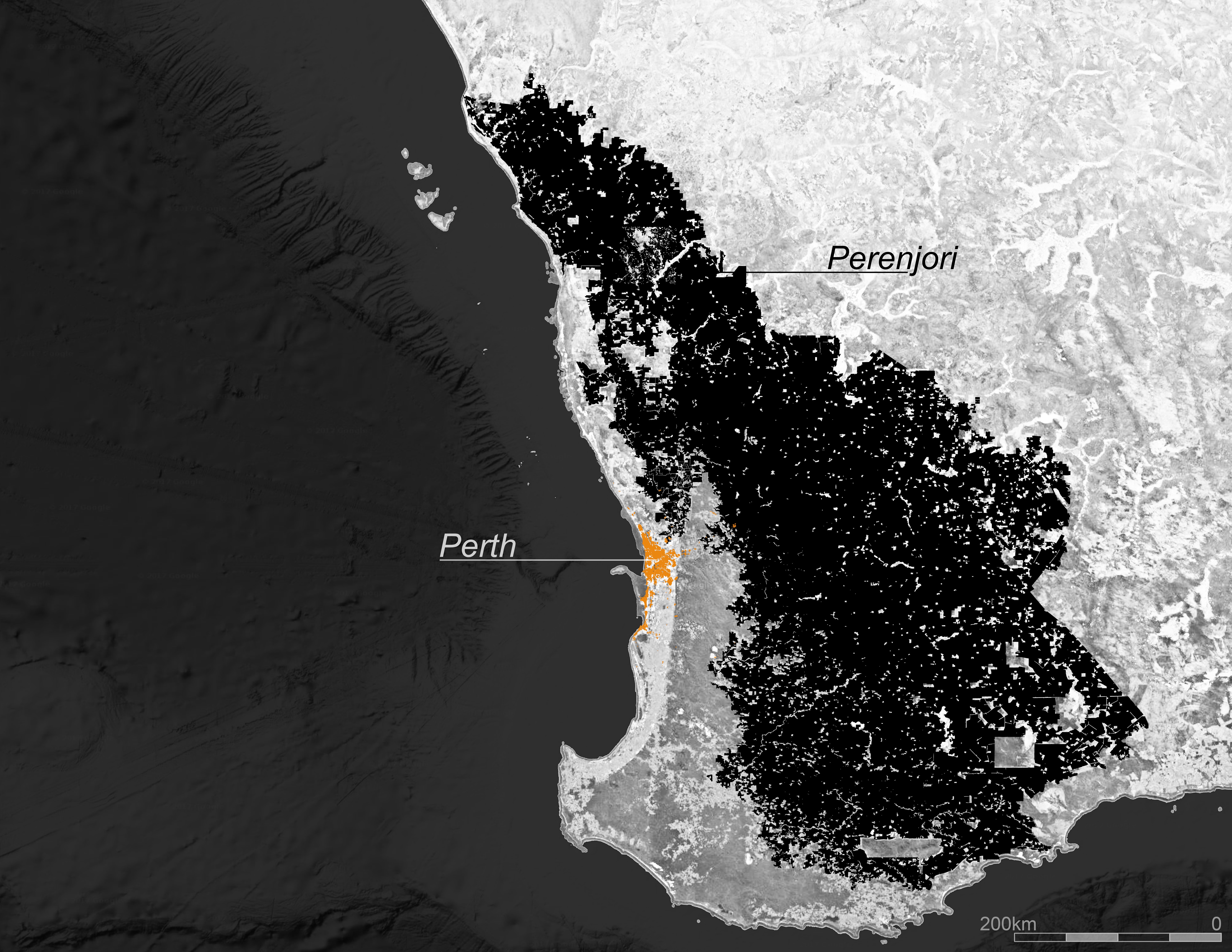
Extents of the Wheatbelt in relation to the Western Australian capital city of Perth. Image by Karl Kullmann.
The Wheatbelt is underlain by the Yilgarn Craton, one of earth’s oldest and most stable geologic formations which generates some of the world’s poorest soils. Free from geological upheaval for 250 million years and isolated from the rest of Australia by ten deserts, the region developed extremely high biodiversity that drew the attention of Charles Darwin in the mid-nineteenth century. In the twentieth century it took just a couple of generations of settlers to replace much of this biodiversity with monocultures of wheat and sheep. At its post-WWII peak, the mass transformation of the land was driven by resettlement schemes for returning veterans, which aimed to clear one million acres of new farmland per year.
The rapid clearing of over 90 percent of the native vegetation caused the naturally saline groundwater levels to rise. Despite the resultant loss of one quarter of productive land to salinity, the sequential development of super phosphate fertilizers, application of trace elements to the soil, and introduction of aerial herbicides and insecticides all helped to maintain grain yields. Railroads were built at regular 30-mile intervals in order to transport the grain to coastal ports. Depots were typically spaced at 9-mile intervals along the tracks, based on the distance a farmer could haul grain. The rail depots were expected to quickly develop into thriving well-populated country towns.
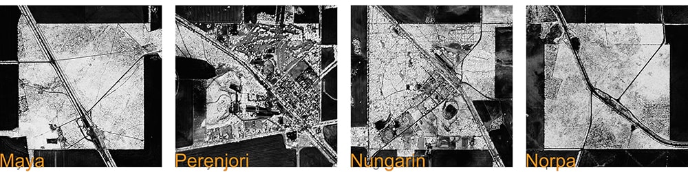
But while appropriate for the frequent hamlets and very small farms of the verdant English countryside, the over-prescription of settlements in the Wheatbelt ignored the realities of sparse population, low rainfall, poor soils and large farms. As a consequence, the majority of the surveyed town-sites were never settled. Scores of their footprints remain today as cardinally aligned 1-mile squares of un-cleared bushland. Officially named, bisected by a railroad aligned to the contour, and often housing a grain silo, these sites offer little else in the way of town amenities. Fortuitously, the squares of bushland that were initially retained as wood fuel for the settlements that never materialized are often the most significant remnants of original vegetation in what is otherwise a sea of wheat.
Leaving the Land
Of those towns that did coalesce into functioning communities, three waves of structural and technological transformations have, over time, eroded their social and economic sustainability. First, an innovation in transportation tripled the catchment radius of country towns with the post-war introduction of motorized vehicles. Second, consistent innovations in communications technologies further reduced the need for administrative journeys to post-offices and banks in rural towns. Both developments undermined the original logic of establishing such closely-spaced settlements.
The third wave arrived quite suddenly in the 1970s with the removal of trade tariffs and sales-quotas. Globalization enforced economies of scale, which in turn resulted in the amalgamation of the original 1,000-acre family farms. Increasing efficiency through mechanization and use of chemicals facilitated farm consolidation, extending the reach of individual farmers into ever-larger holdings, while reducing the need for additional labor. Larger farms meant fewer farmers. In a reinforcing feedback loop, population loss caused local economies to contract and lose facilities and services, which in turn compounded population decline.
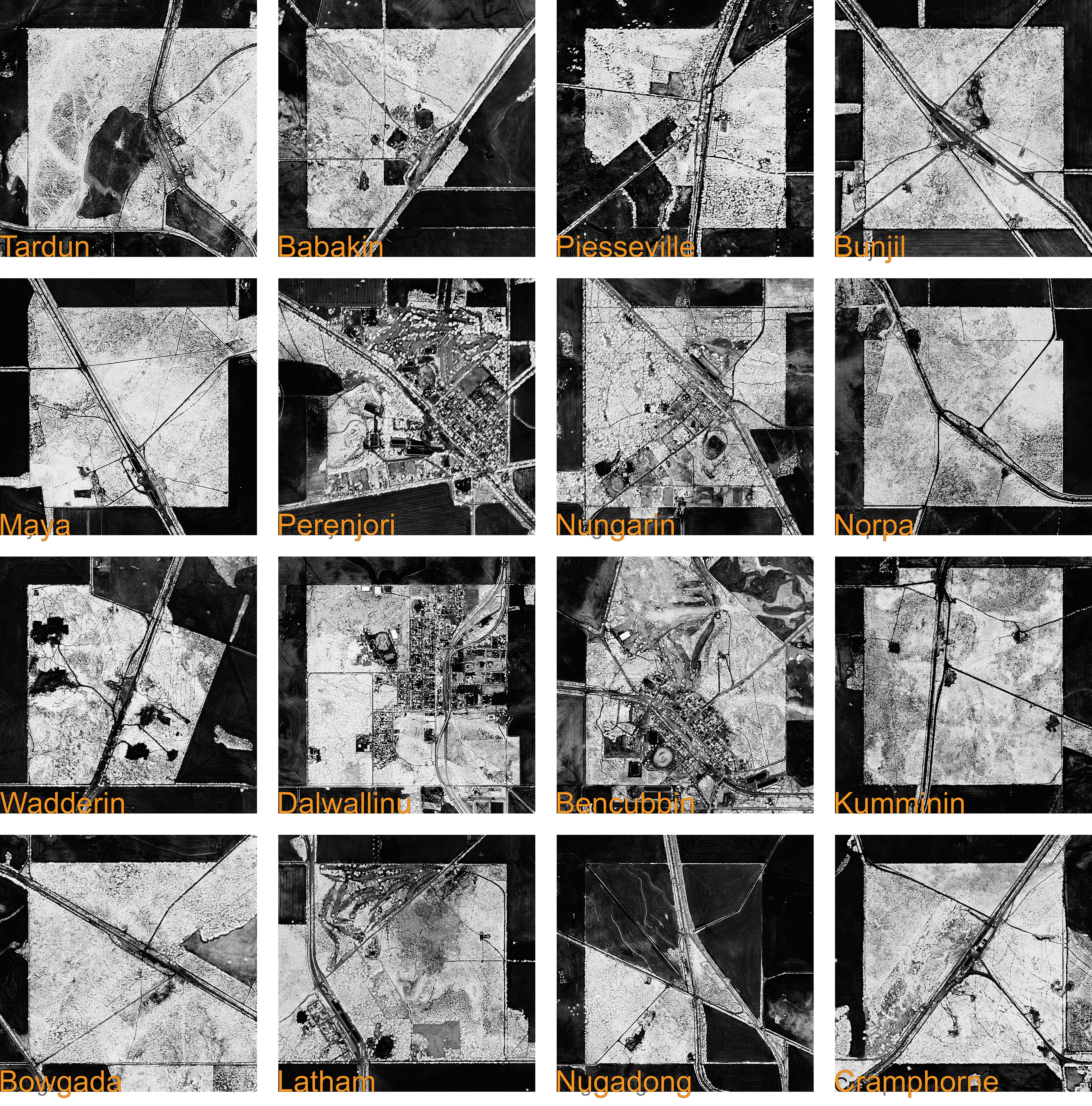
Sample of the 1 square mile rail depots that are distributed at regular intervals throughout the Wheatbelt. Image by Karl Kullmann.
Depopulation laid bare the physical and psychological difficulty of living in such a hostile environment. The enormous challenges that weighed on the very earliest settlers—but which were successfully concealed during the mid-century Wheatbelt cornucopia—returned, with compound interest. Increased rates of farm suicide and marital breakdown tore at the fabric of Wheatbelt society; farm kids that eschewed taking over the family farm for greater opportunities on the coast resulted in severed lineages, family fragmentation and an increasingly elderly and isolated rural population.”
Initially the state government heavily subsidized Wheatbelt communities in an attempt to stabilize and mitigate the negative human and political effects of depopulation. But by the 1980s, the economic rationalism of agriculture deregulation had shifted responsibility for the supply of many key services to local communities. But within this devolved model of government, the smallest, most vulnerable towns often lacked sufficient human and economic capital to begin the very self-assistance enterprises that had the potential to reverse their fortunes.
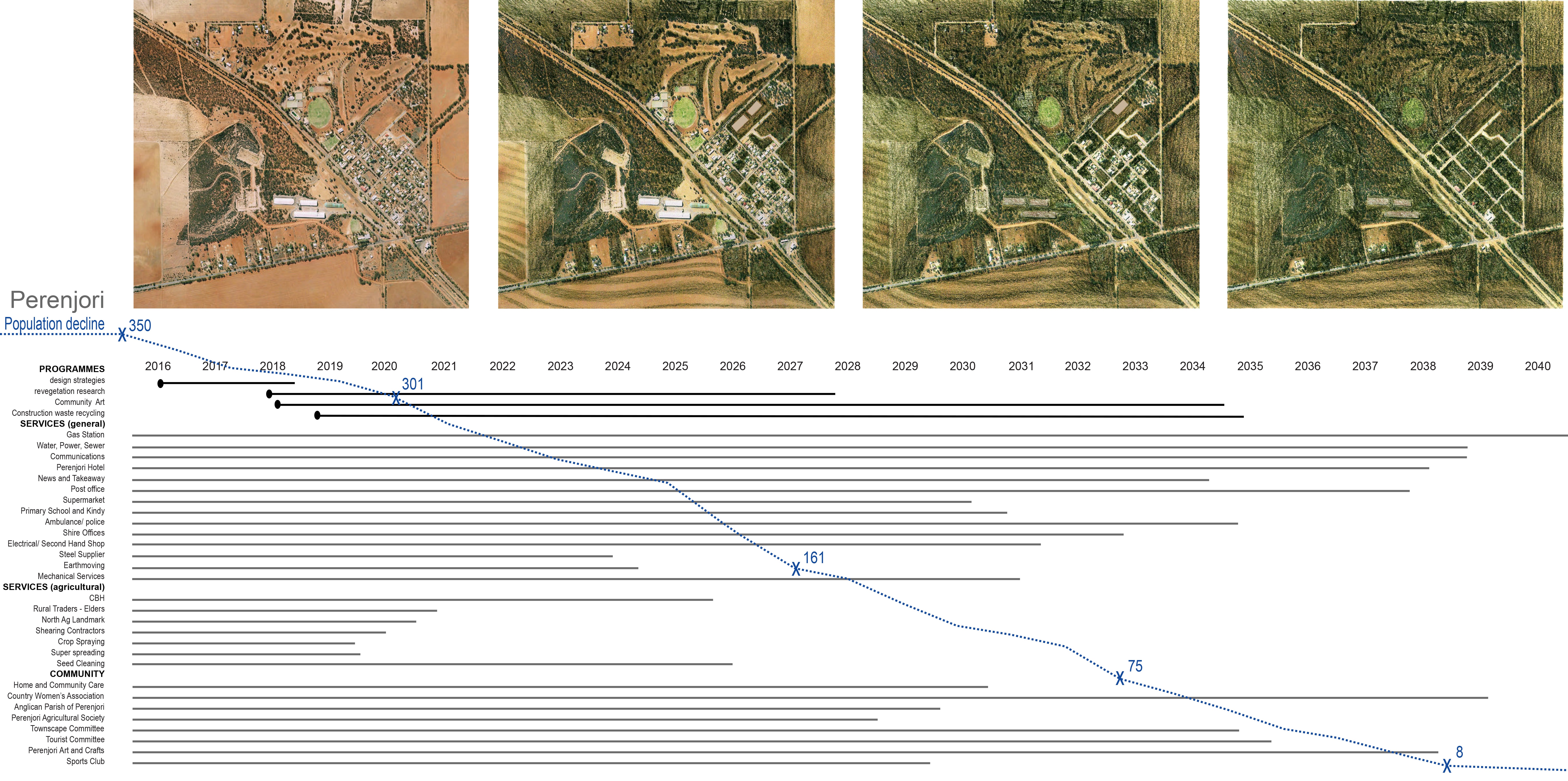
Within this new normal, a handful of Wheatbelt towns have enacted bold strategies in an effort to attract the liquid flows of tourist and investment capital considered essential to slow or stabilize migration off the land. Approaches include tourism campaigns, streetscape and civic space improvements, event organization, and creative projects. At the same time, other towns simply ceased to function as communities. Situated in Australia’s most rapidly declining county with a population of 500 and falling, the town of Perenjori is balanced precariously between these two futures.

Creative projects: Painted grain silo in the Wheatbelt. By Phlegm for PUBLIC Art in the Wheatbelt, 2015. Photograph by Bewley Shaylor, image courtesy of FORM, reproduced with permission.
Precarious Perenjori
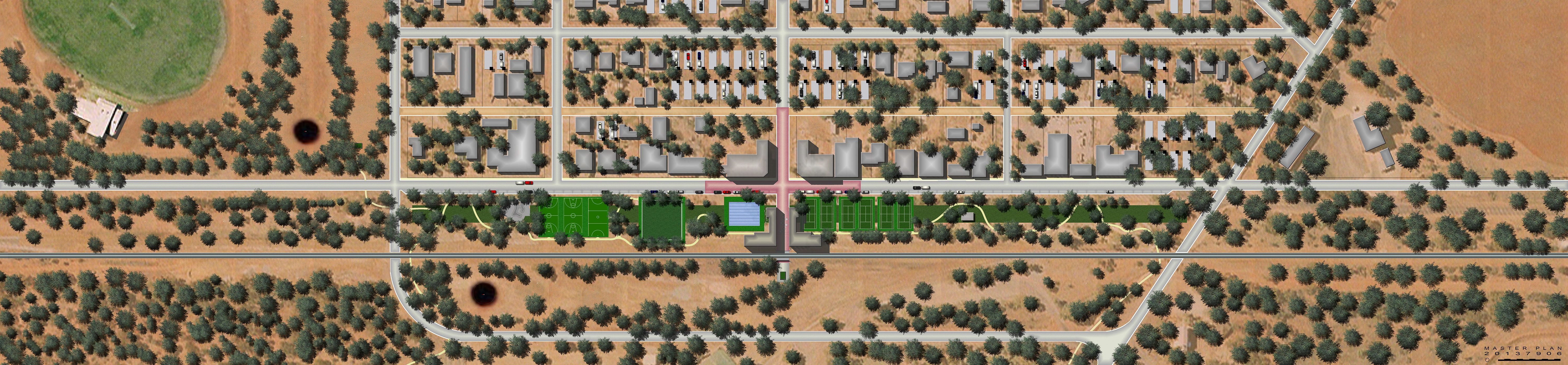
Located just inside the 2,000-mile Rabbit Proof Fence that marks the outer limit of the Wheatbelt, Perenjori is derived from the aboriginal name Peranj-jiddee for a nearby waterhole that lay at the convergence of the Amangu, Kalaamaya and Badimaya people. Although gold prospectors and pastoralists had been in the area for several decades prior, the town formally came into existence in 1913 as a siding and depot along the railroad that facilitated the rapid release of land to pioneering farmers. Through the first half of the twentieth century, the town progressively acquired a main street with a bank, a grain storage silo, a golf course, a cricket/football field, and tennis courts. A trailer park, camp ground, and drive-in theater were added after World War II.
The presence of water, and later Perenjori’s position as the administrative center of the surrounding county, underpinned the town’s persistence while other nearby settlements failed. Despite this status, in the last quarter of a century, the municipal area lost nearly half of its population. In addition to the decline-inducing structural changes afflicting the Wheatbelt at large, the effects of environmental degradation have been particularly acute, with the Perenjori area marked by high rates of salinity and topsoil erosion from over-clearing.
The absence of any dedicated field or organization that specializes in addressing decline compounds Perenjori’s predicament. With the opportunities seen as too marginal and the problems too difficult to interest financiers, entrepreneurs, government agencies, or other professions—designers become the field of last resort almost by default. The lateral thinking inherent in spatial design fits the circumstance, with designers open to stretching traditional scopes and reconfiguring typical decision-making hierarchies.
Landscape strategies for decline
Landscape architecture, in particular, emerged over the past decade as a field particularly well adapted to engaging the problems associated with decline [4]. This is party pragmatic, in the sense that the process of population loss usually replaces buildings with new open landscapes that require attention. But more intrinsically, landscape architecture’s established emphasis on articulating and stewarding processes of emergence and decay suits the challenges associated with decline better than other professions that are more focused on growth and control. Indeed, building on a history of strong environmental and social ethics, landscape architecture presents itself as an empathetic and flexible discipline.
Applying a landscape architecture lens to Perenjori’s situation yields three key strategies for engaging the local impacts of rural-to-urban migration: 1) consolidation; 2) adaptation; and 3) retreat.
Controlled consolidation. Project and image by Ben Liddelow.
Strategy 1: migrating inwards
In settlements experiencing shrinking populations, decline typically occurs in a piecemeal and dispersed fashion. Over time, underutilized structures and under-capacity infrastructures dilute the townscape and isolate community facilities. Eventually, local governments decommission services and demolish surplus structures. Towns become increasingly perforated, with gaps opening up in the commercial strip, the residential grid, in infrastructural areas and public recreation lands.
Consolidating the town into a more compact form is one way to counteract urban dilution. Although relocating the dwellings of remaining local residents closer together would be a fraught and counterproductive undertaking, other land-uses do suggest opportunities for consolidation — chief among these are sporting facilities, which are typically among the facilities most critically affected by population decline. Large team sports such as Australian Rules Football and cricket have fared worst on account of the critical mass of players required to form a team, the greater physical demands, and the implicit age and gender restrictions on participation. Non-team-based sports such as tennis, meanwhile, often remain popular for longer with remaining townspeople.
This consolidation strategy focuses on relocating viable non-team sports from Perenjori’s periphery to vacant land opposite the commercial strip in the core of the town, while simultaneously decommissioning facilities for struggling team sports —especially those with large water-intensive fields and high maintenance demands. Consolidation would allow a single, multi-use sports club to be located in the heart of the town and serve all remaining sports. The central location increases the accessibility of the facilities and effectively reconfirms their importance to community life.
A second component of the consolidation strategy focuses on the trailer park that is popular as a staging point for tourists journeying further inland during wild-flower season. Although the trailer park often houses a significant percentage of the overnight population of Perenjori, tourists staying at its current peripheral location have little reason to interact with the commerce and culture of the town. By redistributing the trailer park from its single peripheral site into non-contiguous vacant lots within the town, visitors would be more likely to interact with—and contribute to — the sense of activity and vitality in Perenjori.

Flat pack garden. Project and image by Adelle Main.
Strategy 2: adaptable development.
Traditional urbanist strategies for reinvestment typically rely on a presumption of permanence. But it was not until the prosperity of the mid-twentieth century that permanent buildings and landscapes were built in the Wheatbelt in styles and techniques imported from Europe. For both the itinerant early settlers and the nomadic indigenous peoples who preceded the mid-twentieth century Wheatbelt boom, adaptable infrastructure that could readily be established, modified and deconstructed was the norm. With the privileging of permanence, the vernacular buildings and landscapes of the Wheatbelt were lost.
An alternative approach would adapt mining industry techniques, wherein lightweight modular structures could be erected as required. To be certain, the modern era is tarnished with an unenviable legacy of prefabricated housing literally being dumped in remote locations, with poor levels of amenity, low quality of inhabitation, and with little or no consideration given for how buildings and their inhabitants engage with the unforgiving environments into which they are cast.
By contrast, this landscape and architectural strategy would provide high-quality flat-pack dwellings that specifically address the unique climatic imperatives of the region whilst being fabricated off-site. The buildings are designed to be more energy efficient, more livable, faster to erect, less labor intensive, and less expensive than conventional building practices that are transplanted from coastal suburban developments [5]. Like the architectural prototypes, the gardens could be manufactured off-site and transported to Perenjori using regular transportation methods. A flat-pack garden, for example, might consist of a simple kit of parts comprised of local flora and farming materials for growing a garden that is both resilient and that can act as a seed bank for re-vegetating the footprint of the dwelling, should the structure be removed or relocated at a future date.
Declining with dignity. Project and image by Eszter Nagy.
Strategy 3: receding/re-seeding with dignity.
The extents of the Wheatbelt were based on the need to settle returned soldiers rather than any understanding of the ecological carrying capacity of the land. With ample environmental degradation as evidence, it is now clear that the eastern margins of the Wheatbelt should never have been cleared for agriculture. Either with or without intervention, the agricultural productivity and population of the Wheatbelt are likely to eventually fall back down to a lower intensity of occupation and use to an environmentally sustainable equilibrium. To be sure, there are numerous precedents for the complete abandonment of farms and town-sites in the region, where decline was uncontrolled and absolute, and which resulted in the eventual re-wilding of cultivated land back into bushland.
Based on the assumption that the socioeconomic forces afflicting Perenjori will continue unabated on their present trajectory, this landscape strategy orchestrates the controlled decline of the town. The seemingly paradoxical intent of this process is for Perenjori to eventually cease to function as a socio-economic hub, whilst retaining a residual sense of place. Steps in the timeline for decline include a combination of inevitable occurrences and deliberate actions that will result in the decommissioning of the town as a functioning rural community. Set over a projected timeframe of twenty years, the process includes the phased withdrawal of services, removal of agencies of governance, progressive demolition of uninhabited dwellings, decommissioning of sporting facilities and finally, removal of the wheat storage silo.
The end game for Perenjori involves the population stabilizing at a very low number, wherein the wildflowers that are a feature of the region would be seeded along the town street grid as a trace of the former settlement. Re-seeding biodiversity into the town is a symbolically important act. This ‘helping hand’ approach would illuminate a key difference between decline in semi-arid climates and decline in the temperate latitudes of the northern hemisphere: in temperate zones, spontaneous ruderal vegetation is the default filler of vacant sites, with verdant growth rapidly veiling cultural artifacts and contributing to their romantic allure. But in dryer climates, re-wilding occurs over a much longer time frame and is contingent to a greater degree on the slow disintegration of manmade structures, surfaces, and infrastructures. By aggressively preparing the land for revegetation, and accelerating the re-establishment of pre-development plant communities, this strategy both accelerates the re-wilding, while still acknowledging the cultural traces of an important layer of history.
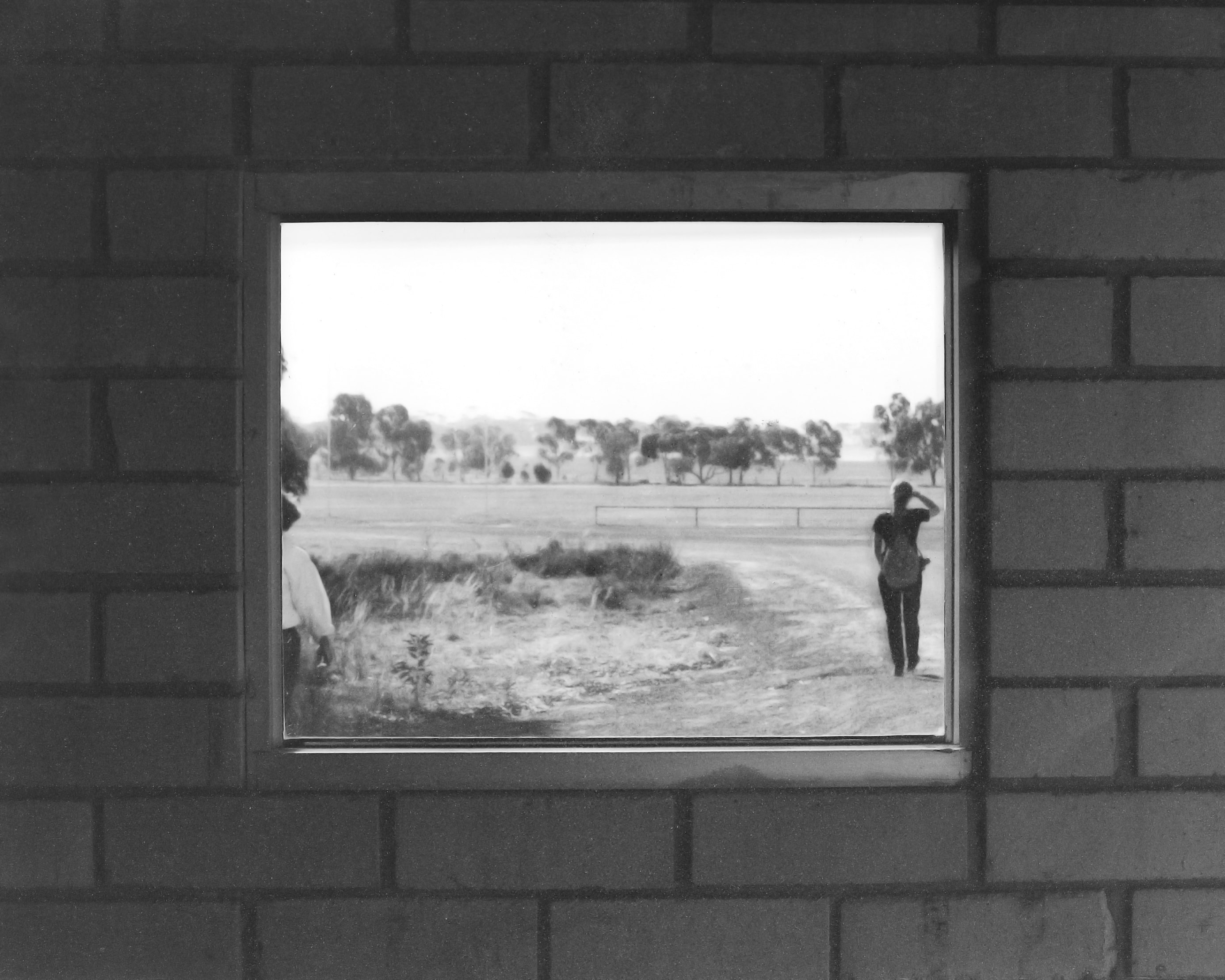
Walking away: Perenjori viewed through a disused bus shelter. Image by Karl Kullmann.
Measuring agency
Establishing the effectiveness of these landscape strategies depends on the criteria for success. Offsetting coastal migration with sufficient reverse population flows back into the Wheatbelt is improbable, given the chronic structural decline, environmental degradation, extreme climate, isolation and aging demographics. However, even though the strategies are unlikely to significantly and permanently reverse population decline, the reductive criteria of economic and population growth tell only part of the story. Expanded metrics for evaluating the outcomes include environmental sustainability, a strengthened sense of place, and a sense of community cohesion and belonging.
Even the traditionally growth-oriented field of economics has absorbed concepts of social and environmental sustainability and has developed broader frameworks for evaluating community performance. These encompass a deeper understanding of the value of a society that reflects the aspirations of its constituents and establishes a sense of place, livability, identity, and creativity. When situated within this broader context, strategic objectives and outcomes that stabilize rural town population, decelerate population loss, or accept and guide the process of decline, are as valid as strategies to return to outright economic and population growth.
Nevertheless, many problems and solutions remain beyond the scope of even the broadest definitions of design. Environmental degradation, social fragmentation, and capital flight require multi-faceted and multi-scaled approaches for which landscape architecture cannot act unilaterally. However, with landscape architecture positioned in a more decisive role within networks and initiatives to engage decline—and less marginalized as is common in growth–based development projects—a range of social and environmental criteria can potentially be elevated in importance.
Of these criteria, the most binding and fundamental is establishment and maintenance of a communal and individual sense of place. Place making is a core tenet of dwelling meaningfully in the environment, and accordingly, critical in addressing rural decline. In this respect, the most fundamental role and potential value of landscape architects is to guide a declining community through crafting, adapting and repairing their sense of place. Here—as it so often does for design in any context—the Law of Parsimony holds true, wherein the simplest solutions that contain the fewest assumptions are usually best. For communities with limited human and capital resources, the simplest strategies are usually both the least expensive and the most robust against failure.
Migrating songlines
Engaging population decline is rarely straightforward or entirely controllable. In certain instances, towns with particular structural, environmental or cultural advantages are likely to endure, although in many cases those advantages will be predetermined rather than able to be invented. In other instances, enterprising towns—often aided by designers—will be able to slow, stabilize, or even reverse the trajectory of decline with strategies that enhance their sense of place. But inevitably, many towns are likely to continue to dissolve as the Wheatbelt settles back to a lower overall population, from which the artificially inflated numbers of the twentieth-century pioneering phase are likely to be viewed a historical anomaly.
Here, design offers far more than the embellishment of the public realm to be indulged during prosperous periods of growth and withdrawn in difficult social, environmental and economic situations. Rather, in addition to seeking to stabilize and revitalize communities, where appropriate the role of design includes facilitating the process of decline in a controlled and meaningful manner. To do this requires shaking what the sociologist Robert Birrell calls “the intellectual hegemony of the ideology of growth” [6]. Removing this stigma potentially reduces the tendency to aestheticize decline as an ‘other’ condition, rather than part of the same global migrations that fuel growth elsewhere. Those flows are now so real in the Wheatbelt—perhaps as real as the songlines are to the indigenous custodians of the land—that they are difficult to trivialize.
 Karl Kullmann is a landscape architect, urban designer, and Associate Professor at the College of Environmental Design, University of California, Berkeley, where he teaches design studios in landscape architecture and urban design, and courses in landscape theory and digital modeling and visualization. Kullmann’s scholarship and creative work explores the urban agency of the designed and discovered landscape. Kullmann has published widely on this subject through diverse lenses, including urban topography, green infrastructure, urban wastelands, public gardens, urban decline, spatial orientation and disorientation, design modeling and visualization, mapping and datascaping.