Brussels’ ecology and urbanity
Belgium’s topography, formed during the “tertiary” pre-ice age, slopes down from South to North, towards the coast. However, Belgium’s main natural systems are East-West oriented, following the gradient of eolian deposits from the Quaternary Period: heavy sand soils wouldn’t travel as far as the lighter loamy soils when blown inland from the sea [1]. The map of Potential Natural Vegetation below shows the clear demarcation of zones of plant communities [2]. In reality, these zones are expressed as a continuous gradient, following the equally soft gradient of soil types. Similarly, forest plants distribute in a mosaic of communities corresponding to vegetation zones, soil conditions, and topography.
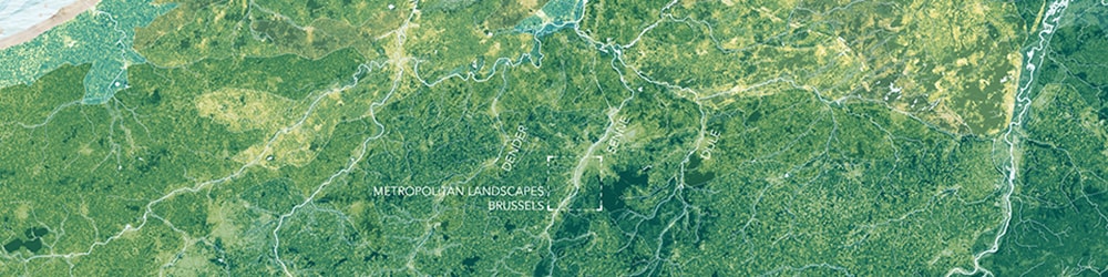
The main rivers crossing the Brussels Metropolis – the Dyle, the Senne, and the Dender – run along the tertiary topography perpendicularly across the landscapes that naturally develop under the soil gradient. These river systems are considered fundamental in connecting different communities and habitats. In the face of climate change and temperature rise, they will only gain importance as corridors for the migration of species that are in search for new habitats where they can survive, following their ideal climatic condition northwards [3].
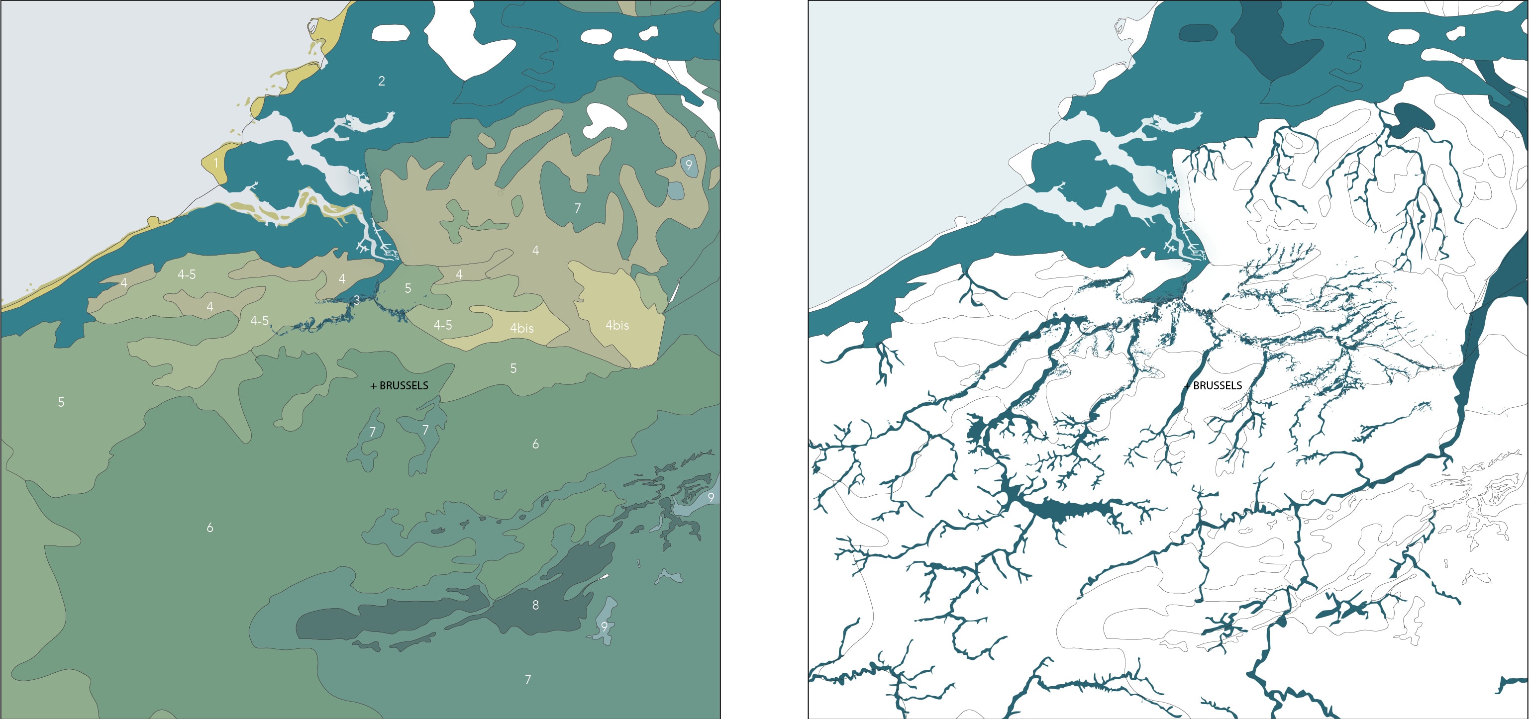
Figure 1. The zonal Potential Natural Vegetation maps illustrate the distribution of plants species in and around Belgium, illustrating the geological sequence of east-west oriented ecological entities and the alluvial river valleys crossing. Legend left: 1-2 Coastal-polder system (dune and alluvial forest); 3 Tidal river landscape; 4 Poor Oak-Beech forest; 4bis Poor sand, heathland, and coniferous forest; 5 Rich Oak-Beech forest; 6 Beech forest; 7 Winter oak and birch forest; 8 summer and winter oak forest.
The Brussels Metropolis lies squarely in the way of the Senne River Corridor. By marginalizing the main water course, the metropolis blocks migration of plants, fish, amphibians, birds, insects and other, in favor of urban movement [4]. Urban infrastructure has manipulated the landscape up to a critical point. In other words, the Brussels metropolis jeopardizes the possibility for nature to adapt to climate change [5].

Figure 2. The Potential Natural Vegetation in and around Belgium more closely to an image of reality: a continuous forest with gradually changing forest plant communities.
Brussels was founded between the forested plateau of loamy soils in the East and the wet, productive alluvial plain of the Senne to the West. The Quaternary deposits on the steep slopes in between, eroded over time allowing the sandy “Brusselian” tertiary layer to outcrop and create a system of sandy slopes. These slopes mark the transition between the upper and lower city. In the city center, they formed iconic spaces: the National Administrative Center, “Mont des Arts,” the justice palace, and “sablon,” now one of the most prominent public spaces in Brussels whose name refers directly to the exploitation of (slightly clayish) sand. In the South, the forested sandy slopes of Forêt Drogenbos were amongst the most attractive spaces for housing due to their green setting and often-spectacular panoramas over the Senne Valley [6].
Today Brussels has overpowered its geological base. Anthropogenic interventions dominate development logic. This is most apparent in Anderlecht-Drogenbos, where the project discussed here is located [7]. The area is highly fragmented by the large-scale city infrastructures that cross the southern Senne Valley: the canal, the railways, the Brussels ring way and their industrial offspring. Each of these pieces of infrastructure changed the topography of the valley, leaving natural flows largely interrupted or crippled [8].

Figure 4. Gradual fragmentation of the Senne valley south of Brussels over time.
The cultural landscape impacts the “continuum natural,” or ecological structure, in its lithological, geomorphological, hydrological and even atmospheric constitution and thus jeopardize the possibility for the Senne valley to serve as a migration corridor for all sorts of species [9]. The cultural colonization of the landscape was never accompanied with any concept on how this ecological continuum might be safeguarded or compensated, or what Ian McHarg stated applies well to this case: “This growth, we have seen, is totally unresponsive to natural processes and their values” [10].
The vocation of the Southern Senne Valley: Brussels’ major flood plain
The Anderlecht Drogenbos site, located south of Brussels and known as the “Southern Senne Valley,” holds a unique ecological and urbanistic position. Here, on the transition between middle-high and low Belgium, the river valley widens, before bottlenecking into the Brussels’ urban tissue. What if we can regain a momentum to establish an ecological corridor for migration by giving the site a main metropolitan vocation: here, the millions of liters of water entering and threatening the city could be halted and stored in an enormous floodplain, effectively ending Brussels flooding problems.
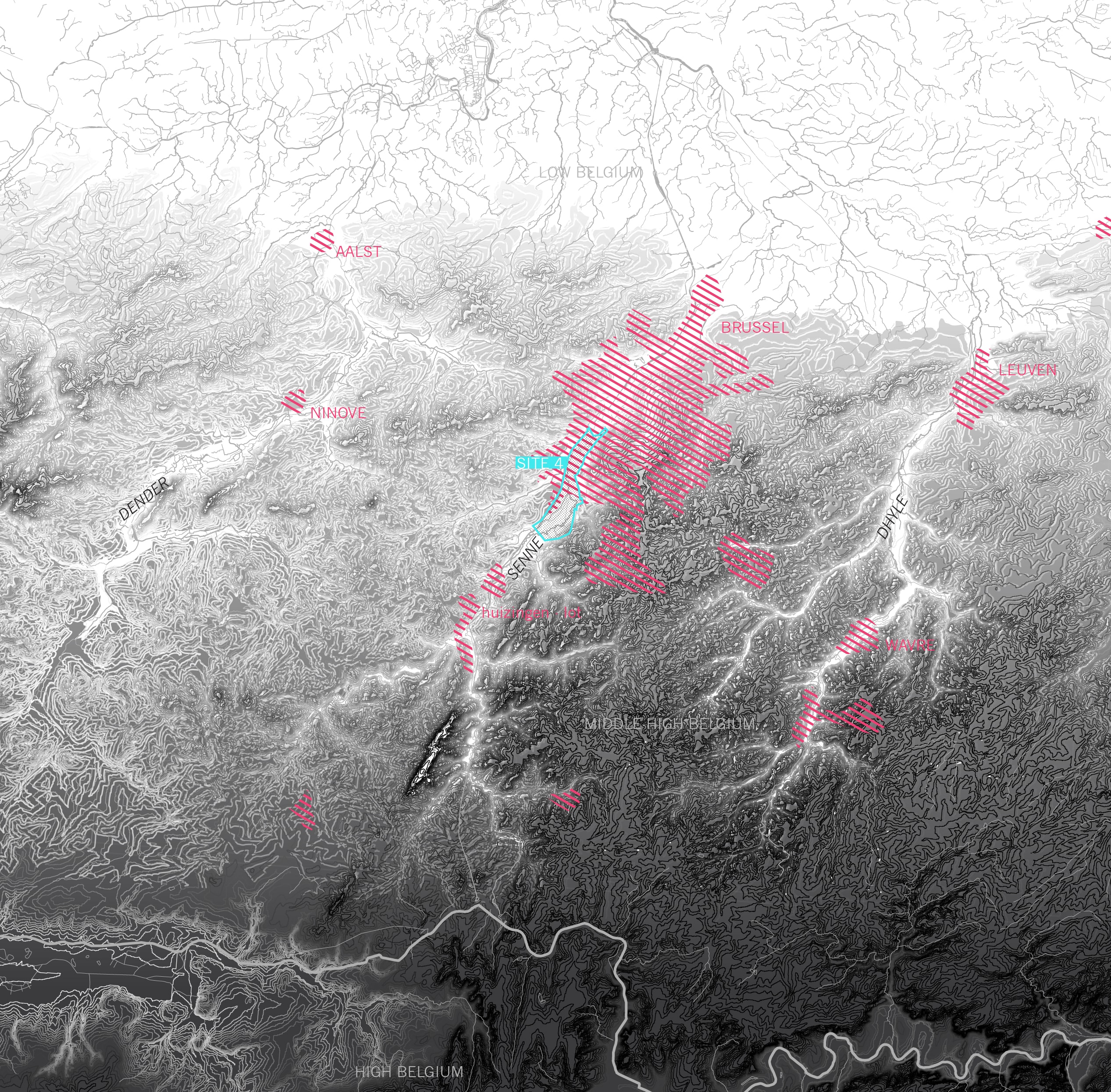
Figure 5. The main topography in the transition from middle-high to low Belgium: Brussels lies squarely on the Senne River. Site four of the research-by-design is strategically located upstream and shows a wide valley, opening possibilities for storing water.
The re-establishment of nature as driver does not attempt to romantically turn back time. Instead, it embraces, even relies upon cultural interventions—the highway dyke, Catala industrial compound, the industrial islands in the valley—as an addition to the geological base, or what is now called the “Anthropocene” [11]. If applied correctly, a new urban ecology can appear that builds on a superposition of layers of infrastructural intervention, such as the canal, railway, and highway, just as ecological communities build upon geological strata. The multiplication of dams will allow huge amounts of water to be stored temporarily, while simultaneously creating a continuous ecosystem of wetlands, flood plains and dry forested areas along the Senne River. Solving the city’s flood problem is the perfect alibi to redesign the natural landscape with its piecemeal cultural interventions into a migration corridor with a high diversity of habitats.
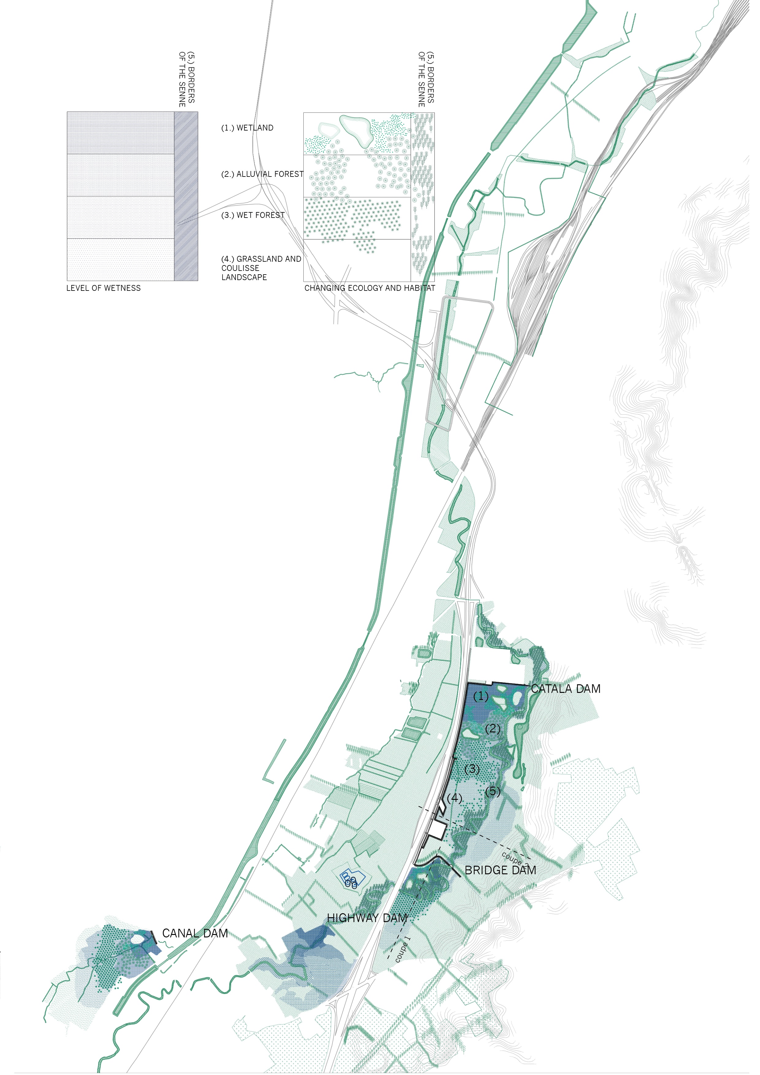
Figure 6. A system of dams creates a reoccurring system of wet to dry landscapes that form interconnected stepping-stones for a high level of biodiversity.
Reconstructing Ecology: soil, water, and forest
To understand the biodiversity of ecosystems, it is necessary to appreciate the central organizing role played by a dynamically varying physical environment [12]. Landscape dynamics shape the urban environment. Urban development typically leads to the reduction of dynamic change and flexibility since these properties introduce uncertainty into an otherwise ordered and engineered system. In this way, peak water flow is calculated and “safely” guided towards a piped system; trees are removed since they might fall or their roots might lift sidewalks; unstable soil is fixed by mineralized edges to prevent potential erosion. Many of these securities are only temporary solutions or limited in their effectiveness. They are mere illusions of safety.
Soil, water, and vegetation are determining aspects of ecosystems [13]. The manipulation of soil alone has the potential to reconfigure the Southern Senne Valley. Through cut and fill operations, preferably with a zero soil balance, water can be redirected, halted or redistributed. Water must be allowed to return to the site and “act naturally,” which means developments can no longer simply guide it towards the safest linear system, the most direct route off of a site, but instead contemplate where water can be, permanently or temporarily, tolerated [14]. The movement of soil and re-naturalization of water creates continuous dynamic gradients of wet to dry and clay to sandy soils. On this rich base, vegetation communities, mostly composed of diverse forests, can reclaim their place. By piecemeal operations, the valley can be shaped into an ecological corridor.
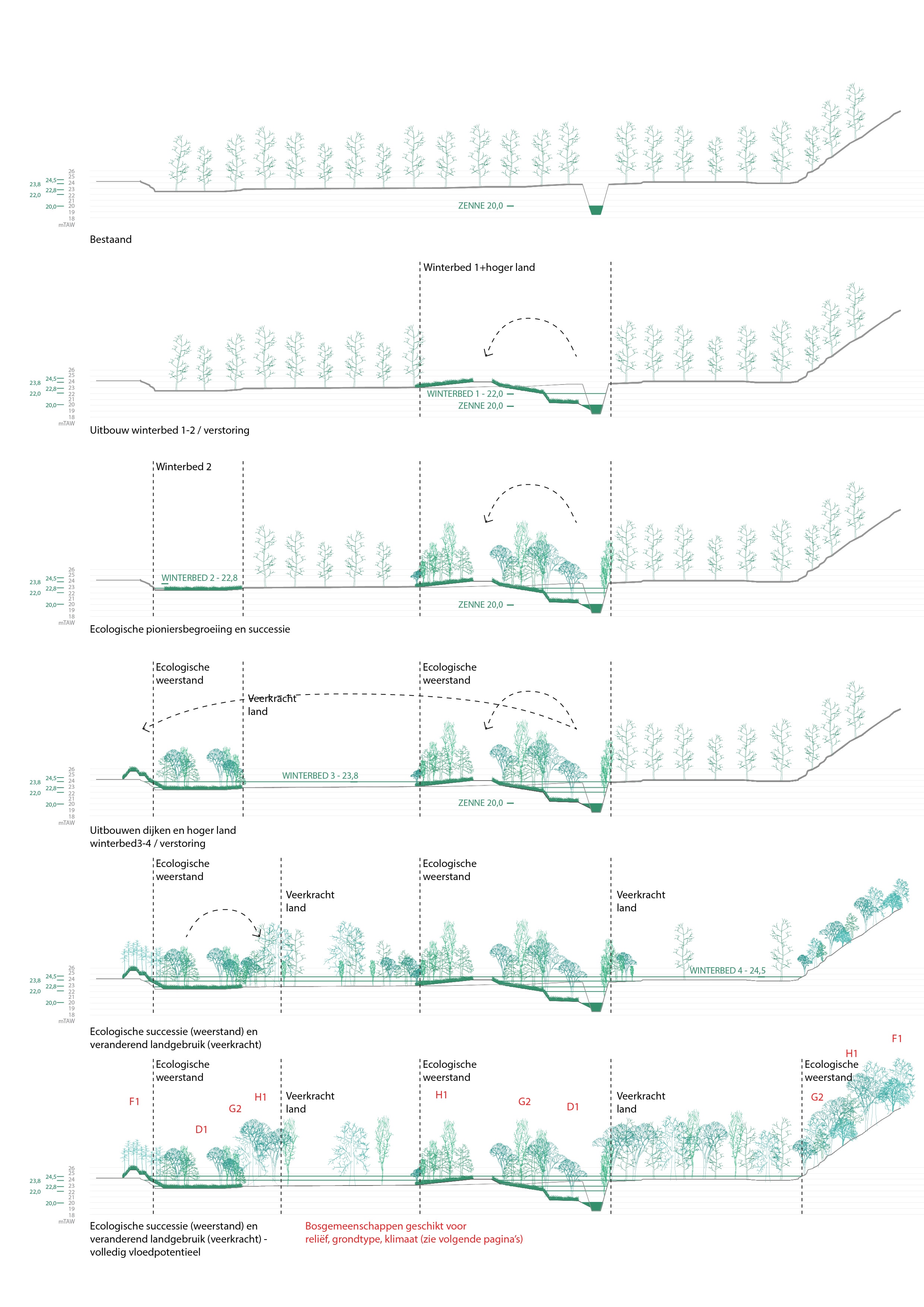
Figure 7. Gradually building habitats: cut and fill operations over time allow for water scraping, which in turn leads to the establishment of forest and the habitat.

Figure 8. Targeted, easily feasible interventions in time condition the flood plain towards a future “natural” state. The engineered landscape becomes dynamic and resilient.
The river alluvial soils are composed of a range of unique geological formations resulting from different cycles of eolian, riverine, glacial and coastal deposits and by cultural adaptations. The alluvial plains can be in some locations dense and continuous, in others locally extremely heterogeneous. Together, they compose Belgium’s varied ecological entities. This diversity comes from natural elements of Belgium’s landscape, but it can also be more intentionally activated for the purpose of ecological continuity, corridor function and the system of stepping-stones that emerge from the soil biodiversity.
Flood + forest urbanism: new urban realm
Floods and forests shape the territory. Floods define “no-go” places for urban development. Forests instead can accommodate the urban. What if we accept that forests are a necessity for the functioning of migration corridors, and for a strong ecological community? We would be forced to imagine an urban realm that develops at the grace of the forest, much like Brussels initially developed at the grace of the Sonian Forest.
Forests that develop in the wet, frequently inundated lands of the alluvial plain are dense and difficult to penetrate. These closed forests only allow for urban settlement at their edges or in a clearing. Forests on sandy soil that are less fertile develop a more open forest structure. Instead of carving out clearings in the forest, urban development can nestle inside its open matrix. In between clearings and nestling inside a range of urban-forest conditions [15]. If the forest represents the architecture of ecology, then we should find an urbanity that fits this architecture.
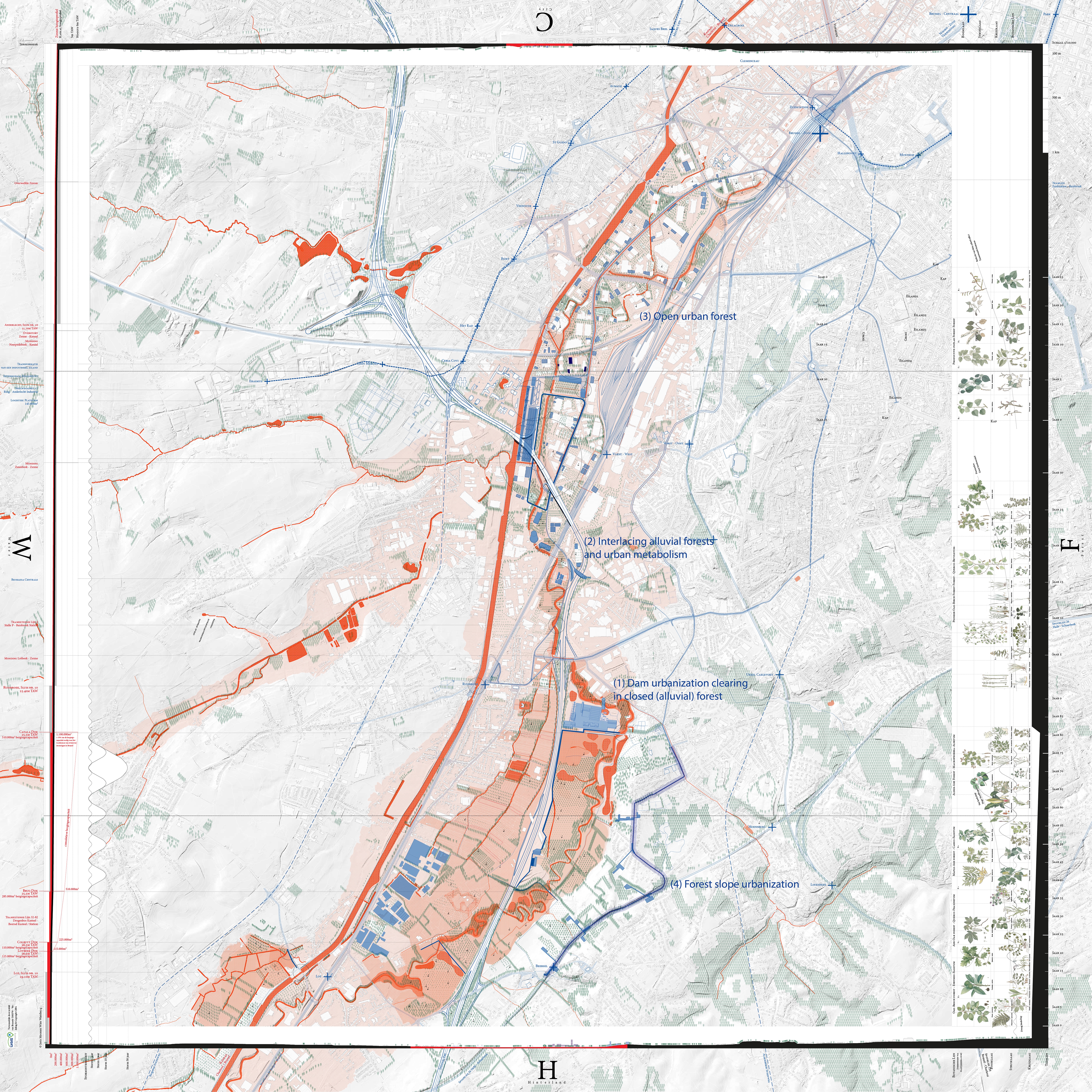
Figure 9. Flood (Water – W), Forest (F) mediate a new migration corridor from the hinterland (H) into the city (C). A range of urban figures appears that fit into the ecological conditions of the migration corridor.
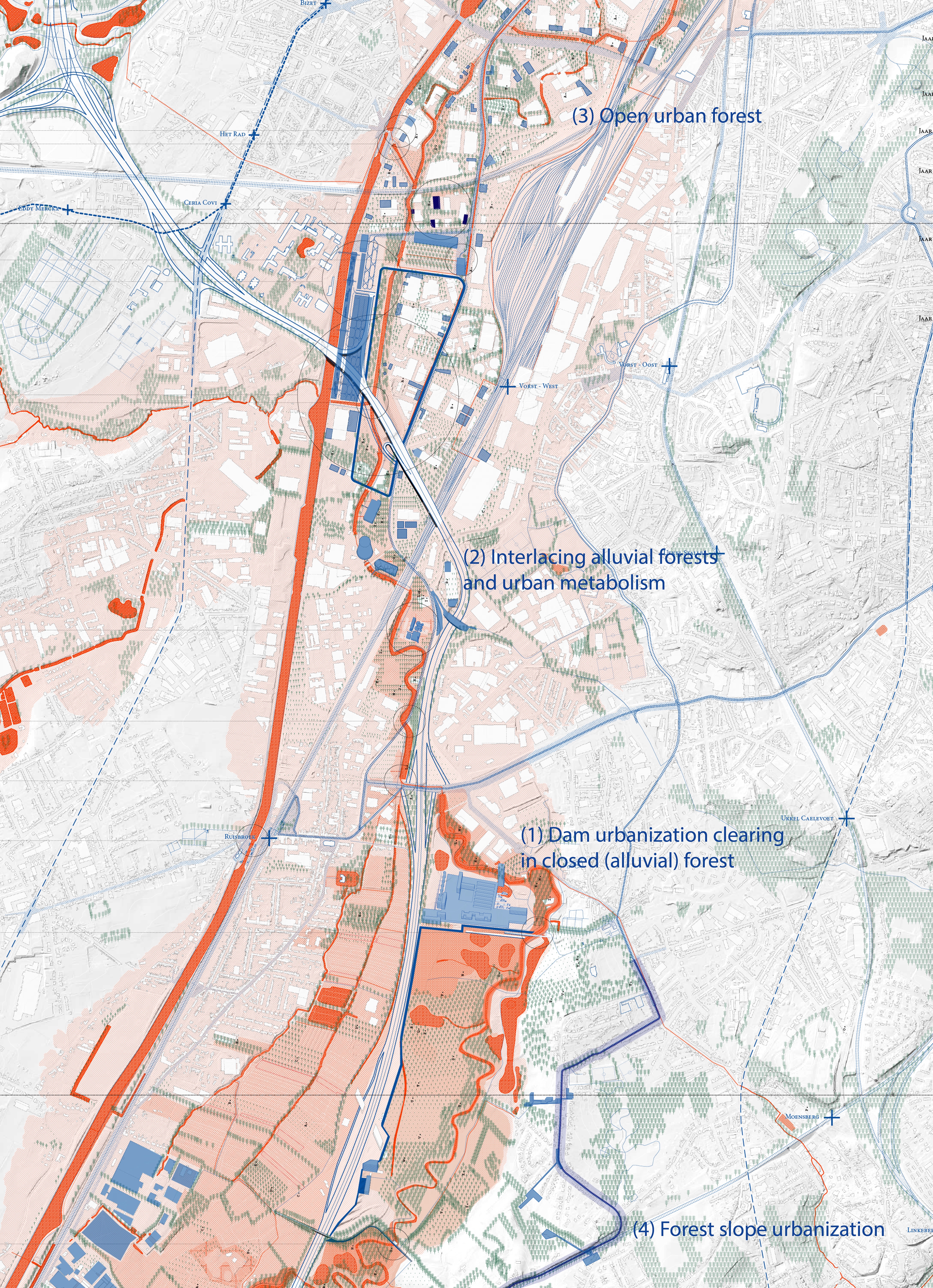
Figure 10. Enlarged plan of intervention, the ecology of the Senne Valley pushes through the urban tissue, conquering space for an ecological continuum however possible: from large (forested) floodplains to a system of smaller linear corridors. The urban system adapts to and benefits from these new landscape conditions.
A pebble in the valley
The project site in the industrial area of Catala, a former paper factory up for redevelopment, sits squarely on the Senne River. If the narrow passages of the Senne around the industrial platform are conditioned to allow only a certain amount of water to pass through, a vast floodplain emerges that can store up to one million cubic meters of water that otherwise would have to be flushed through the Brussels piping and canal system.
The industrial site is like a large pebble in the water. A dense, partially productive, partially residential program could be welcomed here. Surely this unique location as a pebble in the water, and a clearing in the dense alluvial forest would be the pretext for a different urban lifestyle. One could understand the disruption the clearing means in the ecological system, and simultaneously understand that it is exactly this pebble that makes the ecological corridor function at the scale of the metropolis.
Water and forest: the metabolism of the city
On the border between the Brussels-Capital Region and Flanders, the valley has been invaded and encroached on by a lot of “peripheral” industrial functions, which have been pushed away from the city center. Most of them use water for industrial processes: the energy plant uses water for cooling, the chemical plant uses it in their production processes. Here the Senne is seen as part of an industrial network, which is easily considered damaging, problematic or incompatible with a sustainable water ecology.
What if we embrace these operational aspects of the river and incorporate them within an ecological system, rather than considering them off-limits? By closing the water cycle for each of these processes and making the different water functions of the industries work together, a new habitat can be created that finds its origins in the industrial processes. This habitat is not fragile and does not survive “despite” the industrial processes, but “at their grace.” In turn, the landscape can even take up a role in the industrial process (e.g. in contributing to decreasing water temperature or aiding in water purification processes).
The privatized nature of industry would allow the ecological corridor to remain largely untouched. Here, the alluvial forests would not be publicly accessible since they are part of the operational frame of the industries and must to be protected. Nature can thrive. Sporadic “machines,” part of the industrial operations that organize the water exchanges, would be tolerated in this landscape since they strengthen the function of the water landscape.

Figure 11. Urban metabolism: different flows join through a Combined Heat and Power plant that uses waste as a resource. Urban functions support pioneer vegetation in the valley.
An industrial urban forest
The industrial islands in the alluvial plain in Anderlecht are synonymous with ecological disaster. Flooding is frequent, hence the safe islands and the relative temperature is higher than elsewhere in Brussels due to the extent of paving and the urban heat island effect. What if we radically overthrow the notion of the “island”? Can the island be synonymous for the ecological transformation into a piece of the Senne Valley migration corridor?
Here, the components of the island are exploited: the sandy plateau allows for an open forest to absorb the industrial buildings and to introduce infiltration and evapotranspiration to combat the temperature problems. The island serves as a management system to rationalize the use of space. The internal mineral circulation is given up for afforestation, yet space for intensified industrial activities can be found. Finally, the island no longer represents a safe distance from the alluvial plain. The island is an integral part of the ecological system, containing gradients from dry to wet, from sand to clay to loam. The Senne River will be allowed to meander through the islands and thus permeate the industrial tissue as a network of narrow ecological connections. If the connections are not generous in size, at least there are many.
The island approach allows for growth and development over time. Island by island, zones can transform at their own pace. At the speed of a growing tree, the urban forest emerges.
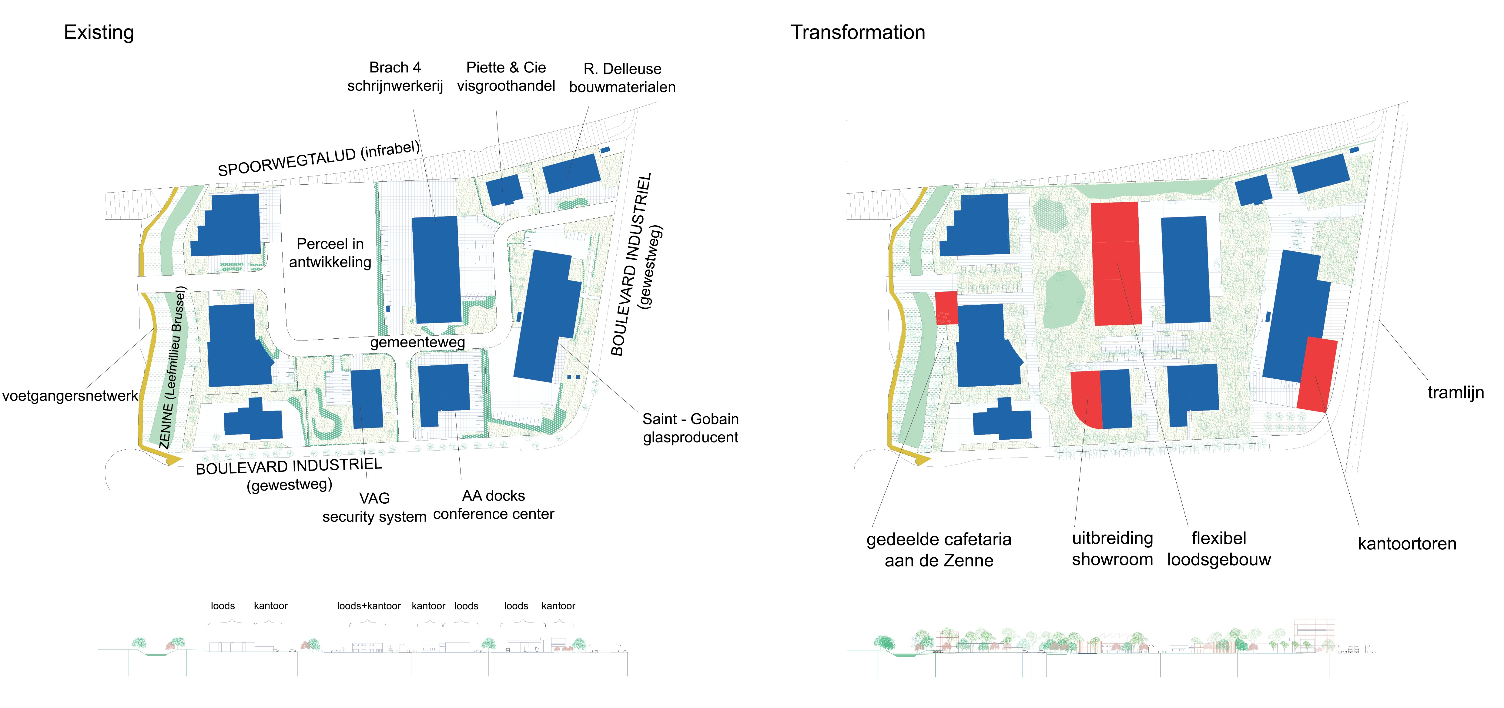
Figure 12. Weaving the urban forest through the industrial islands by inverting space management from individual to collective.
Forest intimacy and panoramic views
The eastern slope of Brussels forms an iconic edge between the valley and the forested plateau. In the city center, the slope is accentuated by a system of iconic places. In the south, the slope should represent a different urban and ecological approach. The extension of a tram line along the edge, to fill in the mobility gap between tram and train, is evident. Could this tram extension break from the “business as usual, transit-oriented densification”?
The tram extends towards Beersel Castle, serving as the destination of a voyage through the forests of the eastern slope. Much like the Tervuren tram connection, the use of public transport is more than a functional habit. The voyage is an alternating experience of the open panoramas on the Senne Valley and the closed intimacy of the slope’s forests. A democratization of this quality should exist, and densification of the tram line can be done punctually. The future research question is then clear: what would an urban form look like that embraces this view and the intimacy, without compromising this experience from the tram?
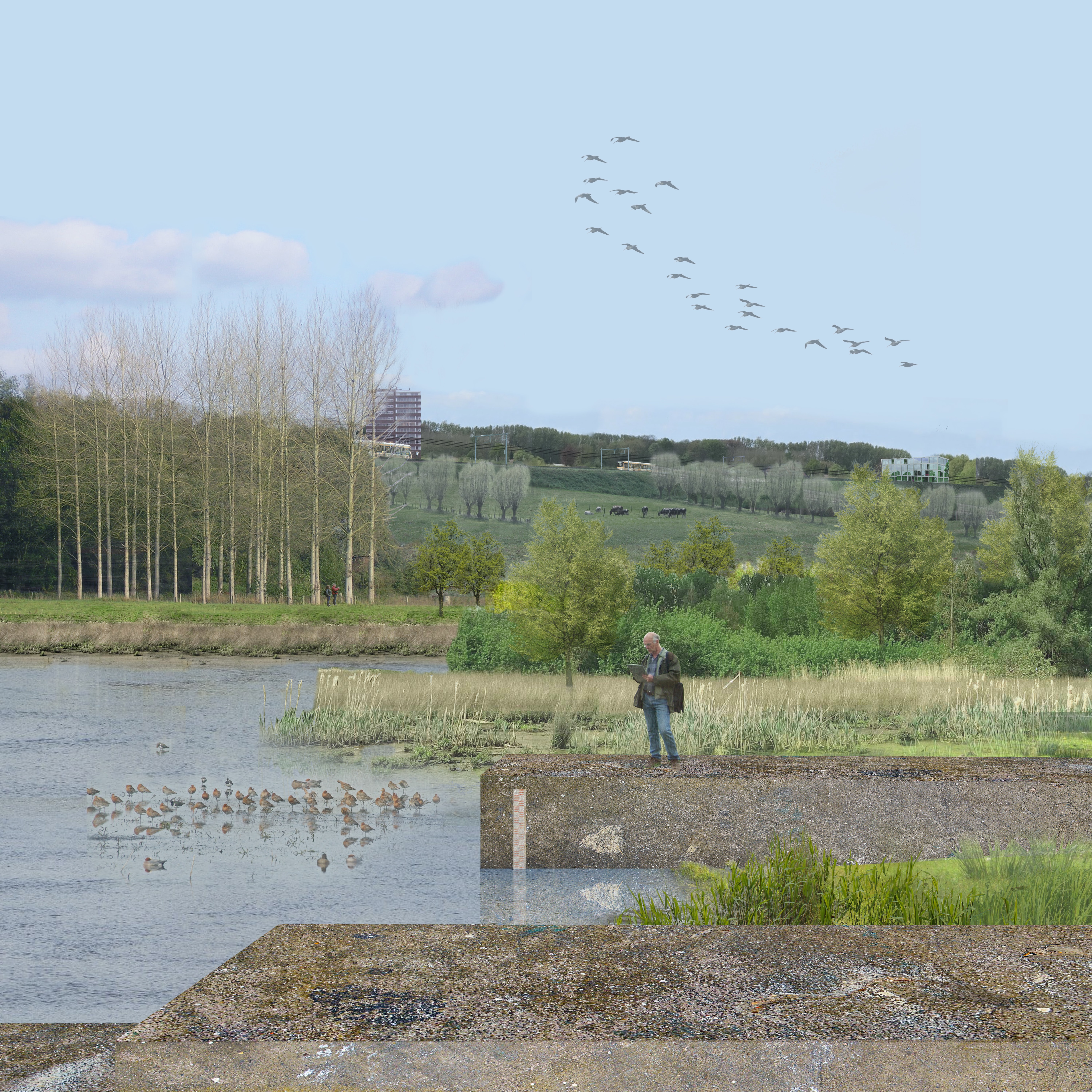
Figure 13. New dams hold the water. The gradient of landscapes from bottom to top illustrates the rich and continuous biodiversity created close to the city, ideal for the migration of species. The urban overlooks the floodplain. A new scenic and functional tramway traverse the forested flanks of the migration corridor.
Conclusion
The project illustrates the intention to restore ecological continuity through three main steps: first, a clear vocation was given to the migration corridor: the major flood plain of Brussels. This mentally prepares the site for a major transformation, gathering the different stakeholders needed to realize such an ambition. Secondly, the classic concept of “city building” is overthrown. We should no longer add to the urban proliferation of intervention with a sole purpose of urban evolution. Each cultural intervention, by different stakeholders or in different moments in time, should contribute to establishing the “continuum natural,” or ecosystem. Natural and cultural forces should be synchronized to accommodate natural processes. Finally, the urban realm is in need of a paradigm shift. Housing development should be embedded in the new ecological structure, not deny it, nor ignore it, but actively search for it and exploit its many opportunities. An urban realm that forms a critical part of the ecosystem is more likely to support and defend it. The notion of “forest urbanism,” an urbanism that fits inside a variety of forest types, and is capable of inhabiting, not erasing the diversity of local vegetation communities of Belgium, could be valuable to explore in support of these new ways of living.
Credits
This project was developed within the framework of “Metropolitan Landscapes,” a research-by-design study commissioned by the Brussels Capital Region and the Flanders region in 2015 to investigate the role of open space in the Brussels Metropolis based on research-by-design by Bureau Bas Smets. The author of this project is WIT Architects with the Research group for Urbanism and Architecture (RUA) of KU Leuven in collaboration with Annabelle Blin and Philip Stessens. Figures 9 and 10 represents the further development of the project design by Joris Moonen (WIT and RUA) and Wim Wambecq (RUA) that is currently displayed at the Vlaams Bouwmeester office in Brussels.
Wim Wambecq (1984) is an architect (2007), and urban designer (2009) graduated from the universities KULeuven, IUAVenetië, TUDelft, and UPCBarcelona. After a few years in the practice of urbanism and architecture at Brussels and Milan-based Italian office Studio Associatio Bernardo Secchi – Paola Viganò, he is currently working on a doctoral dissertation that investigates the interplay between urbanism and forestry in the nebulous Flemish city. Except for European Urbanism, he is also active in design studios on landscape urbanism in East and South African development contexts.

Bruno De Meulder (1960) studied architecture at the University of KULeuven where he also developed a doctoral dissertation on urbanism in the Belgian Congo. Currently, he teaches urbanism at the KULeuven where he is director of the post-graduate programs of human settlements and urbanism. In his research theory and practice, analysis and design, history and contemporary urban practices cross.