Sea level rise is steadily reshaping coastal landscapes, leading to profound changes to ecosystems and habitats. Rising seas are elevating groundwater, pushing saltwater into coastal aquifers, killing coastal forests, squeezing wetlands, and accelerating beach erosion. They are also having a visible impact on many aspects of the urban fabric: flooding intersections and basements, causing the overflow of septic tanks, and undermining foundations. In some places salt water intrusion during high-water events such as the lunar king tides is corroding sewer lines, contaminating freshwater drinking water wells, and causing sinkholes far inland.
Despite the expanding list of visible threats, coastal communities around the world continue to grow faster than noncoastal zones [1]. And in spite of the prevalence of contemporary discourse around resilient urban planning and design, traditional planning standards and codes continue to enable construction that shows little regard for the threats posed by climate change.
Why is it that coastal land use continues to remain static when we know that these coastal landscapes are so dynamic? The pressures of accelerating coastal change demand a new responsive and flexible zoning paradigm that introduces time, process, and potential into land use regulation. This essay asks how land-use controls can be reframed and recoded to permit diversity and incentivize flexibility.
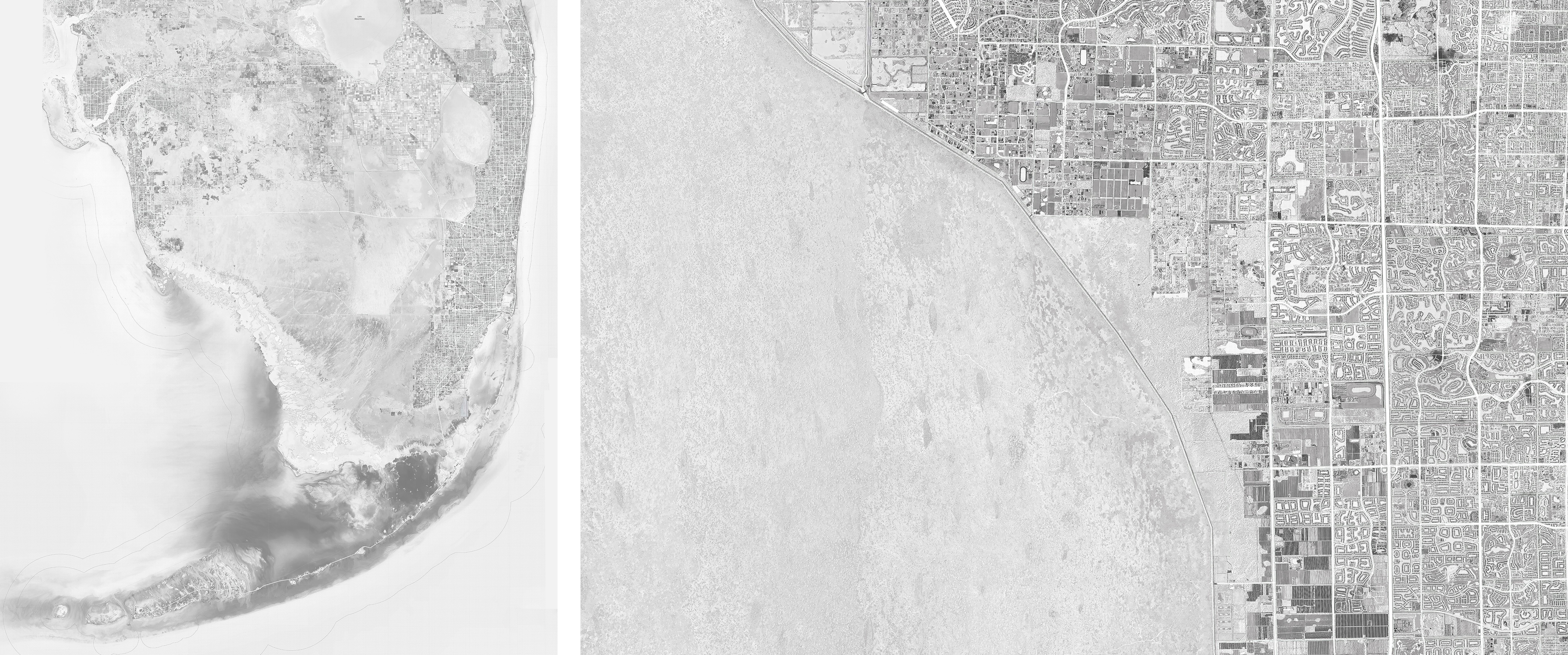
South Florida’s urban fabric is surrounded by water on three sides. Images by Fadi Masoud.
South Florida is drowning
Nowhere in North America are the patterns of precarious coastal development more visible than in South Florida. With nearly 20 million residents, Florida is one of the United States’ fastest growing regions, as well as one of its most threatened. Most of South Florida is low-lying, and its cities are surrounded by water from the three sides; the Everglades to the west, the Atlantic Ocean to the East, and the Biscayne Aquifer in porous limestone below. South Florida’s extensive suburban landscape is enabled by the continued manipulation of a dynamic estuarine environment and a pervasive real-estate-driven housing pattern. Thirty-five miles of levees and 2,000 hydraulic pumping stations drain a metropolitan area of 6,137 square miles (15,890 km2), resulting in the ‘world’s largest wet subdivision’ with $152 billion worth of property projected to be below sea level by 2050 [2].
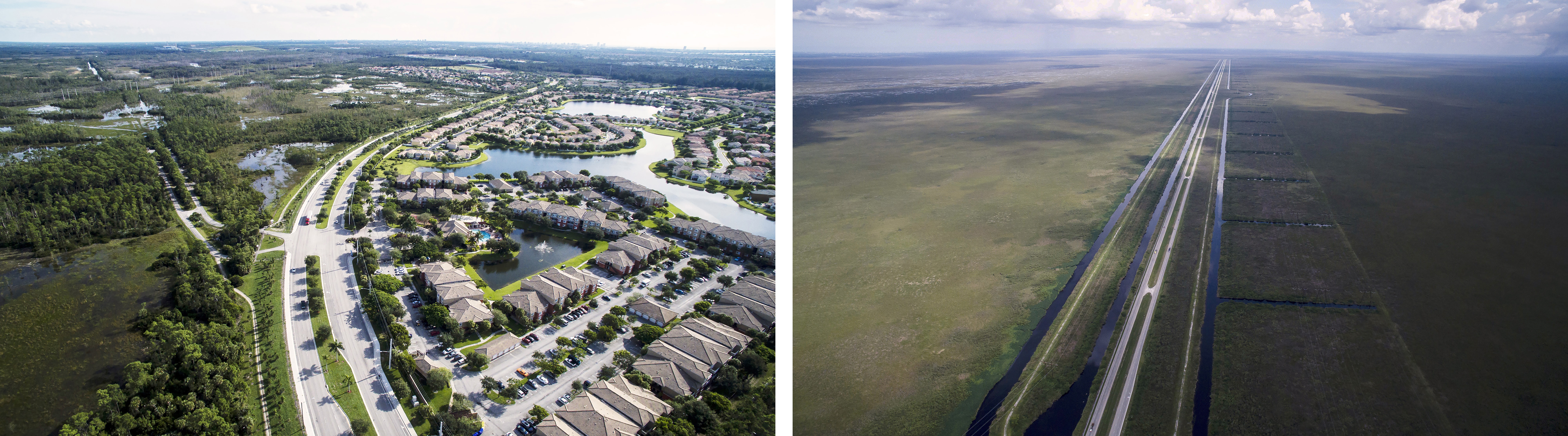
Suburban Planned Unit Developments in Weston [right]; US Highway 27 and canal cutting through the Everglades [left]. Photos by Matthew Niederhauser and John Fitzgerald: Future of Suburbia Exhibition – MIT Norman B. Leventhal Center for Advanced Urbanism.
A recent study conducted by University of Georgia geographer Mathew Hauer estimated that thirteen million Americans — many of them in the Southeast — are directly at risk of being forced to move due to sea level rise. Many of these future climate migrants live in Florida, which is set to lose as many as 2.5 million residents by the end of this century [3].
If this imminent migration is to be curbed, South Florida’s urban fabric must adapt to changing water levels. The overall structure that currently defines Florida’s metropolitan areas results from the combination of hard infrastructural lines, developer-driven master plans, reductive normative zoning, and prescriptive form-based codes. Thus far, conventional planning tools have proven inadequate in dealing with the increased vulnerability caused by Florida’s inherently dynamic ecological forces and constantly fluctuating environment.
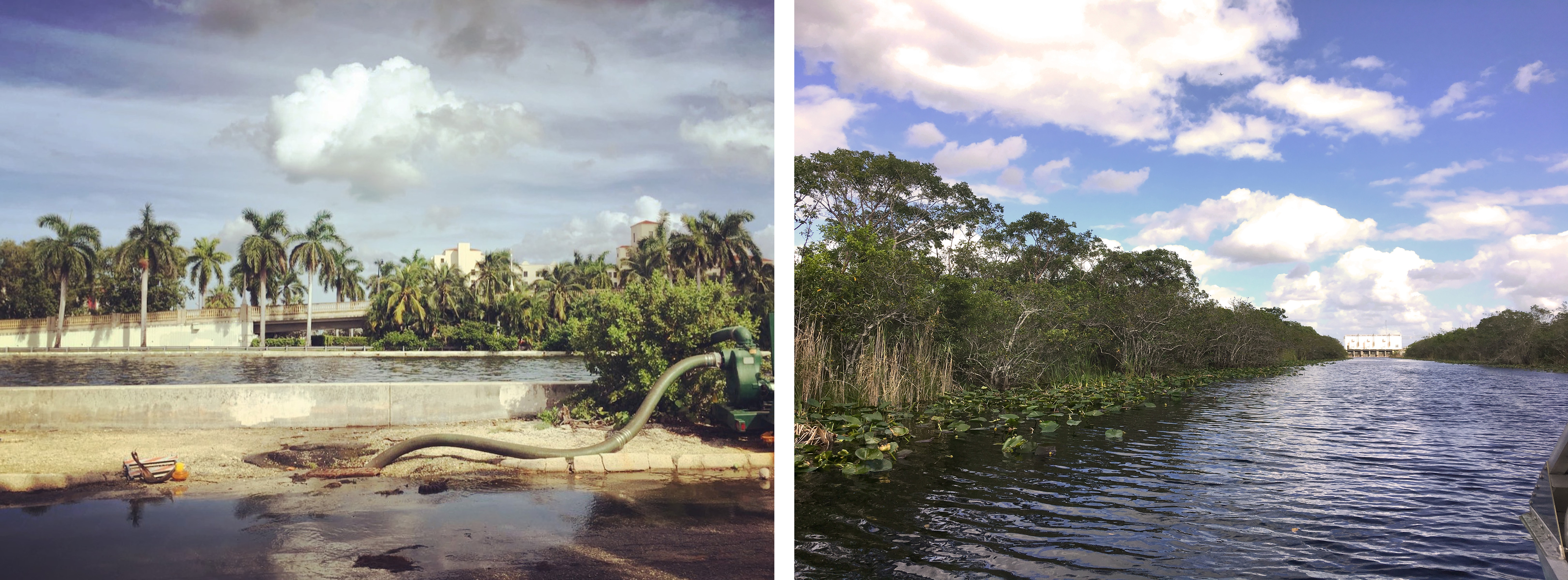
S9 Pumping Station and C-11 Canal in Broward County [left]; Road-side pumps near the Intercoastal Canal in Hollywood post Hurricane Matthew (October 2016) [right]. Photos by Fadi Masoud.
Static Planning in a Dynamic Landscape
“For once it is realized that there is no harmony of nature, no divine or other purpose hidden beneath the flux and chaos of present planlessness, it becomes immoral to let poverty, ignorance, pestilence, and war continue if they can be obliterated by a ‘plan.'”
– Dwight Waldo and High T. Miller, The Administrative State: A Study of the Political Theory of American Public Administration [4]
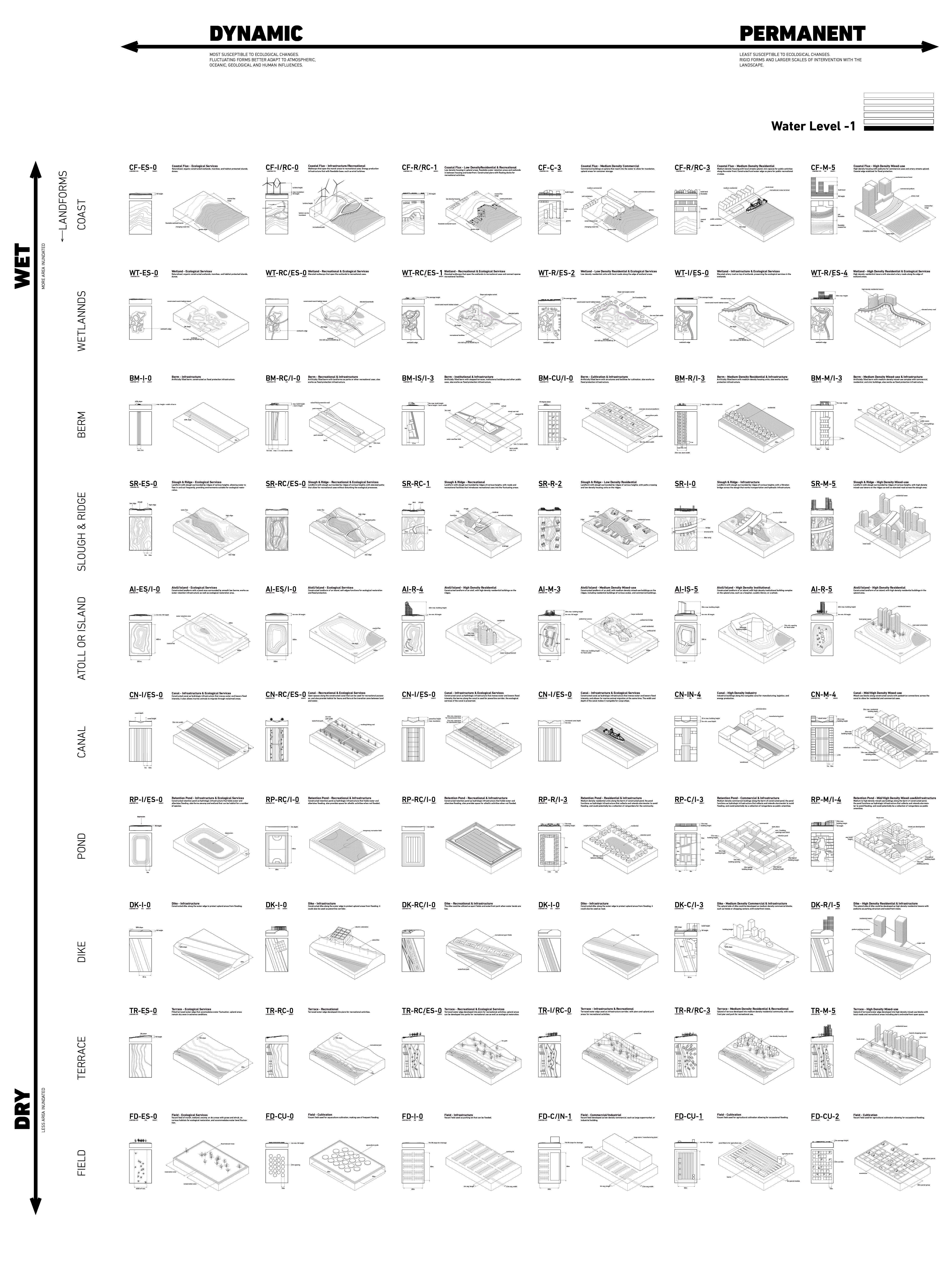
Normative or traditional zoning has historically relied on two conditions: on the regulation of land and the regulation of use. However, the interrelationship between land and use — the temporal conditions and processes that govern their fluctuations — are poorly suited to the predictive economic model of land use planning. Therefore, we posit a third condition, a layer of the zoning envelope that introduces time, process, and scenario-driven flexibility into land use regulation. In this third condition, program and use are governed by the evolution and flux of the land. Under our “flux” code zoning, the crisp Pantone-colored reductivism of conventional land use would thus transition into a series of overlapping gradients, eliciting a multifunctional, dynamic understanding of land use that is absent from current regulation.
The politics of conventional land use and zoning have long been intertwined with ecological developments in the natural sciences, beginning with the very codification of the planning profession. Political scientist Dwight Waldo, a defining figure in American modern public administration during the post-World War II era, helped to solidify the ethos of the planning discipline as one that could achieve higher objectives as an administrative profession. Drawing on the ecological paradigms prevalent in his day, he advanced a notion of an “equilibrium” reached through formulaic standards that would abolish “planlessness,” increase legibility and control, and eradicate the potentials of indeterministic chaos as a moral public imperative. Today, zoning remains the most influential and pervasive regulatory tool ever deployed. It is largely responsible for the shape of twentieth-century land development in North America, and to some degree, planning regimes around the world [5].

Four ecological paradigms have had a direct impact on public policy in North America. Image by Fadi Masoud.
There are four distinct ecological ideas that have directly shaped public policy and legal institutions in the Unites States [6]. The first set of these policies, during the Progressive Era, were highly influenced by ideas of ecological “empiricism,” where scientific thought comes from factual reasoning rather than abstract principles [7].The second, which focused on the concepts of “succession, climax, and equilibrium,” developed by ecologist Frederic Clements, had the most profound impact on American planning and the passing of the Standard Zoning and Enabling Acts during the late 1920s [8].
The third followed the expansion of the concept of metabolic habitat and the eventual development of systems ecology [9]. These were subsequently supplanted by contemporary paradigms of non-equilibrium or dynamic systems, which describe the environment as being in a constant state of change, and that public policy must therefore take account of random and nonlinear disturbances rather than assume an ideal state of nature [10]. Even though the interpretation of ecological succession as a linear process and the notion of an inevitable climax state have been displaced in both the natural and social sciences decades ago, these theories continue to underpin contemporary zoning and land use policy, persisting in well-established real estate concepts such as “highest and best use” [11]. As concerns over the environment propel us to imagine new, dynamic models of urbanization, contemporary ecological theory offers a foundation for rethinking the mechanisms of conventional land use planning.
The visible effects of climate change have transferred this from a theoretical debate into a pragmatic necessity in an increasing number of coastal cities. As rising sea level threatens to make large swaths of territory unfit for traditional site development, municipalities must begin to shift from zoning for an idealized end-state of “best use” towards zoning in a way that embraces change, multiple endpoints, and uncertainty.
This new reality requires regulatory instruments capable of managing open-ended ecological processes and systems. Flux-based zoning code negotiates the elastic elements of ecological indeterminacy within the precision and instrumentality of planning tools. This fluid codification scheme suggests the potential to embed novel and unique land use standards that emerge from dynamic, process-driven ecological paradigms rather than traditional static, object-based codification.
A series of projective speculative “flux” codes that combine performative landscape measures with built form and a dynamic variable. Image by Fadi Masoud.
On Broward County
Faced with the threat of sea level rise, coastal erosion, and increasingly powerful storms, four Florida counties — Broward, Miami-Dade, Monroe, and Palm Beach — came together in January 2010 to form the Southeast Florida Regional Climate Change Compact. This novel form of regional climate governance is specifically designed to allow municipalities to set the agenda for adaptation while providing an efficient means for state and federal agencies to engage with technical assistance and support.
Broward County has relied on the “Average Wet Season Water Table Map” adopted in the year 2000 to guide water management decisions and water quality protections. However, year after year, for the last decade, weather patterns and sea levels continue to deviate from their “historical baselines,” with measured increases in sea level contributing to increases in regional groundwater elevations and saltwater intrusion.
Models indicate that the trend of wetter weather and rising waters will continue, with an estimated 24 inches of additional rise and 9.1% increase in precipitation possible in the 2060-2069 timeframe. In this context, historic baselines may no longer be an appropriate predictor of future behavior or a relevant reference for engineering decisions. Rather than relying on historic baselines when planning zoning, land use, building code, and surface water management systems, municipalities would be wise to use projected water levels.
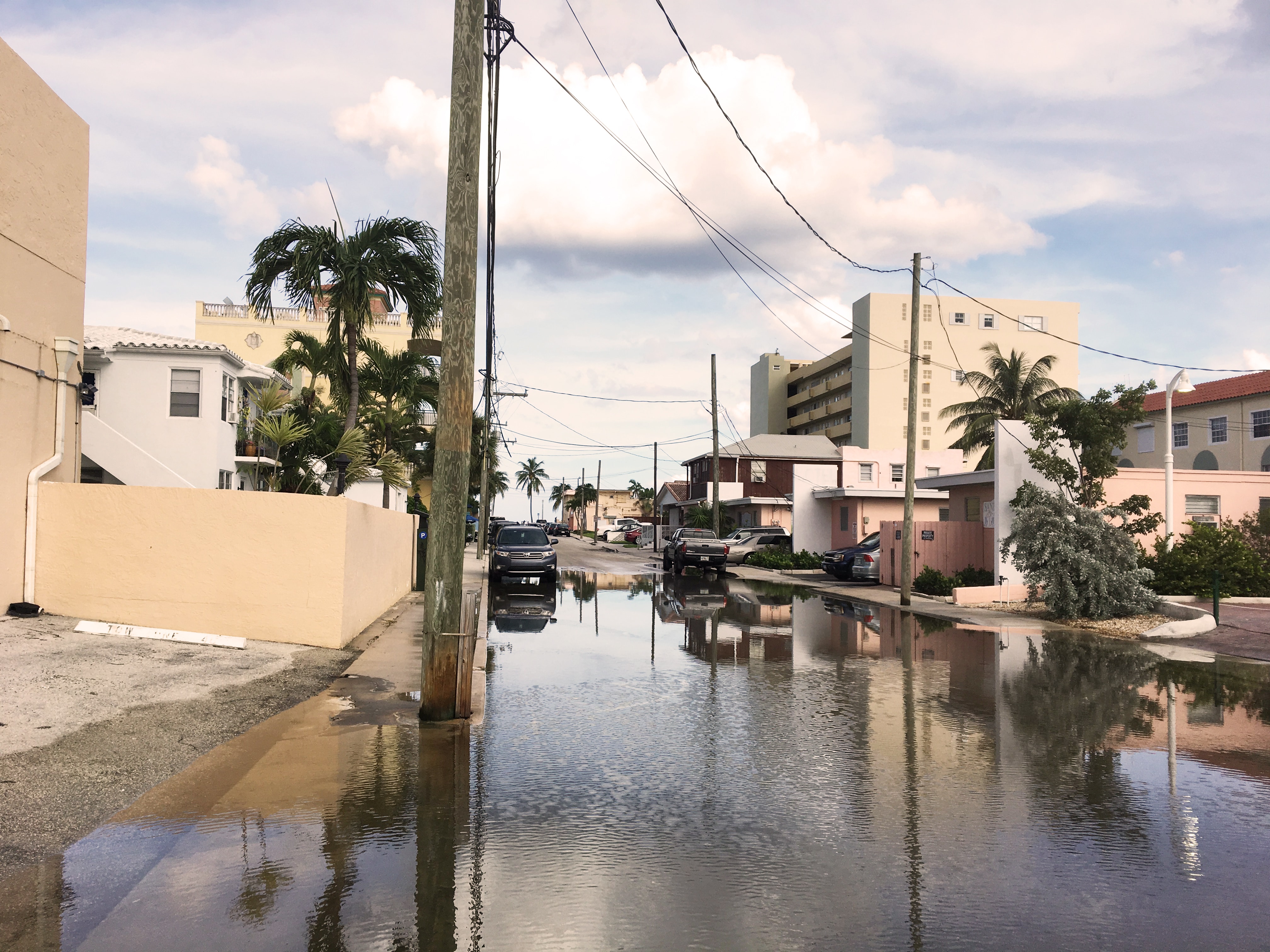
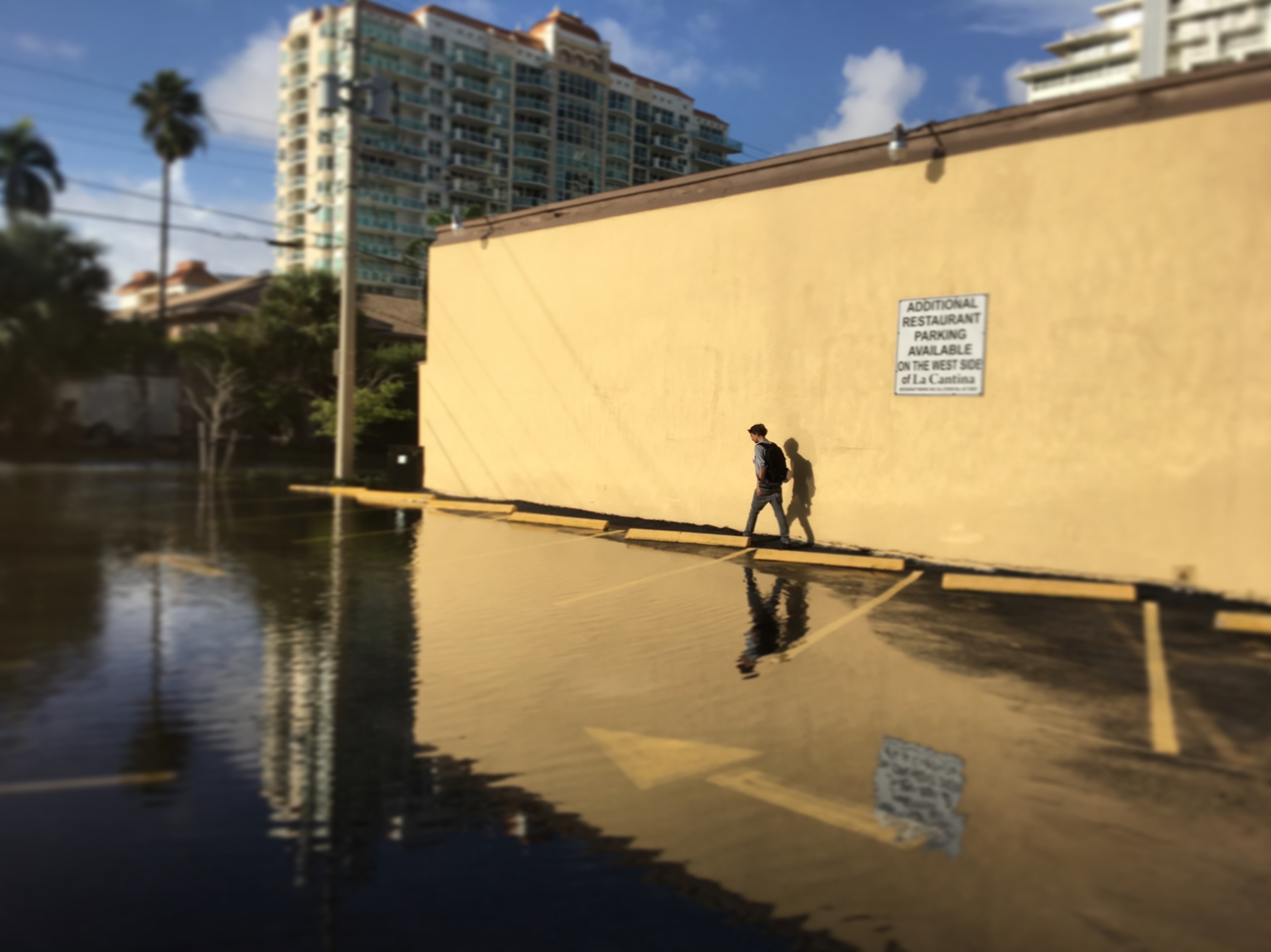
Hollywood and Dania Beach flooding post Hurricane Matthew (October 2016). Photo by Fadi Masoud.
On November 10, 2015, the Broward County Board of County Commissioners accepted the Updated Regional Sea Level Rise Projection (2015) and an updated Wet Season Water Table map that accounts for future predicted conditions for 2060-2069 as the new basis for sea level rise adaptation planning [12]. This shift from historic patterns to projective ones rendered obsolete the old static “object-based codification,” and signaled the need for novel forms of adaptive and dynamic zoning codes, land uses, and standards.
Complex policy structures shaping the urban fabric of Broward County and South Florida. Image by Dennis Harvey, Pamela Bellavita Carvajal, Ranu Singh (MIT Urban Design Studio 2016 – Masoud / Mazereeuw).
Flux Zoning in Broward
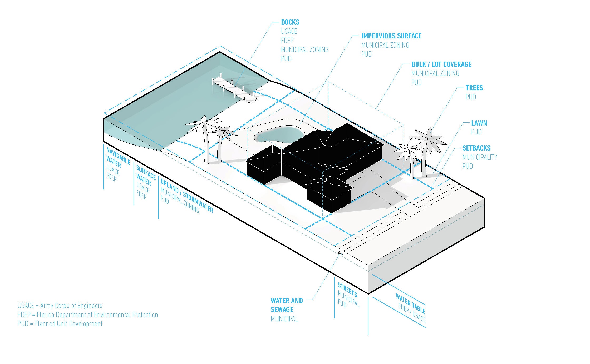
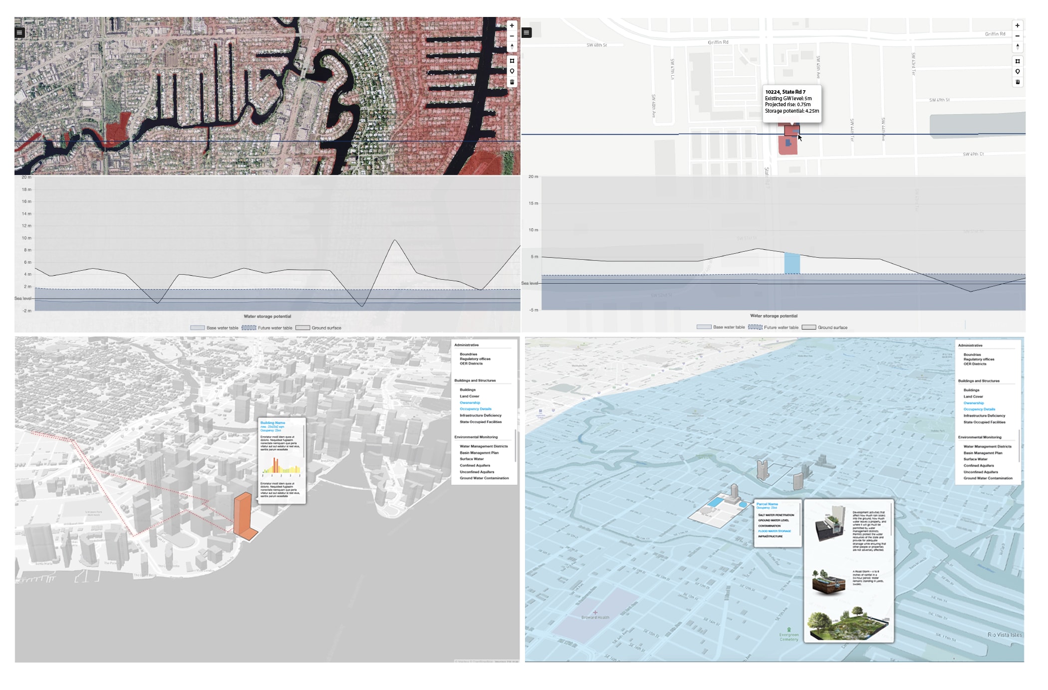
The demand for projective and responsive zoning has prompted our team of researchers from the University of Toronto and the MIT Urban Risk Lab to establish a collaborative partnership with Broward County’s Environmental Protection and Growth Management Department. Through ongoing research and design studios, the project aims to develop a novel form of county-wide zoning that relates fluctuating groundwater table levels (tides, storm events, runoff) to the physical condition on the surface (permeability, building footprint, heights, foundations and use). We call this approach “flux zoning,” due to its ability to represent a range of projected future conditions. Rather than treating land as static and flat, and thinking about planning only in plan view, from above — our approach instead looks at zoning in section, treating both the surface elevation and the vertical depth from surface to groundwater as key components in determining potential future land use. In our prototypical “flux” zoning code, the design of land, use, and infrastructure are relationally bound to a variable, projected future water table.
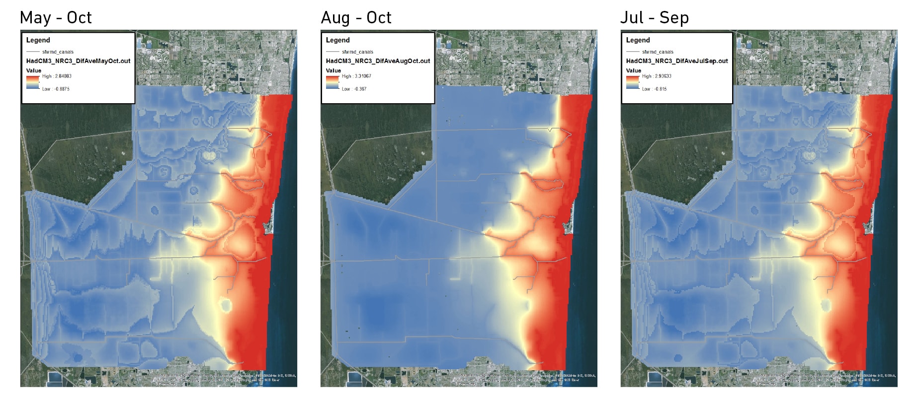
Ground water storage potential models. Blue: Highest Storage Potential; Red: Lowest Storage Potential. Image by Broward County Environmental Protection and Growth Management Department (2016).
In a series of modeling illustrations generated by Broward, a dynamic “Flux-Zone” is shown as a yellow gradient that follows the north-south natural topographic ridges between the coastal “red” zones and the inland “blue” zones. This area is representative of a site where we may introduce the “third condition” of zoning as it sits between substantially saturated ground with no storage capacity and areas susceptible to flooding. Control gauges and gates on canal systems running east-west demarcate the “yellow” flux-zone and the extents of salt water intrusion into the groundwater aquifer. Within the “flux-zone,” land use, topographic manipulation, and building code may be imagined as interrelated and interconnected in a series of scenario-driven land use regulations.
Earlier in 2016, the Deputy Director of Environmental Protection and Growth Management in Broward County, Leonard Vialpando, presented conceptual “third condition” zoning work at the Regional Climate Action Plan Implementation Workshop: Essential Tools: Integrating the Southeast Florida Sea Level Rise Projections Into Community Planning. Key concepts such as clustering development along elevated transit corridors and ridges, inland islands generated in the “flux zones”, and the design of interconnected water corridors as open space, were all being discussed as near-term adaptation strategies.
The platform reveals sectional relationships between the built from and ground water conditions. Image by MIT Urban Risk Lab and University of Toronto Daniels Faculty (Masoud / Mazereeuw).
Over the coming months, the research team aims to devise a set of unique “third condition” zoning codes, land uses, programs, and typologies for the “Flux Zone.” Various physical and environmental conditions ensure that drainage and surface water management systems will achieve appropriate storage and water quality treatment levels while allowing for a range of possibilities and scenarios to occur. The most fundamental of these is the depth from surface to groundwater, a parameter that influences soil storage, building type, land use, flood condition, site-specific water management options, and the effectiveness of drainage system components.
The code is animated to demonstrate the critical dimension of time, and includes a sectional depiction (through section-axonometric illustration). New programs and land use types are organized in a matrix of gradients that go from the most dynamic, adaptable, and elastic elements of the region (appearing along the wettest axis), to the most fixed and static elements appearing along the driest. By incorporating the indeterminacy of the shifting broader environmental systems, with the pervasiveness and exactitude of planning code, we establish an opportunity for the instrumentality of policy to be both a part of the design process and a progeny of it.
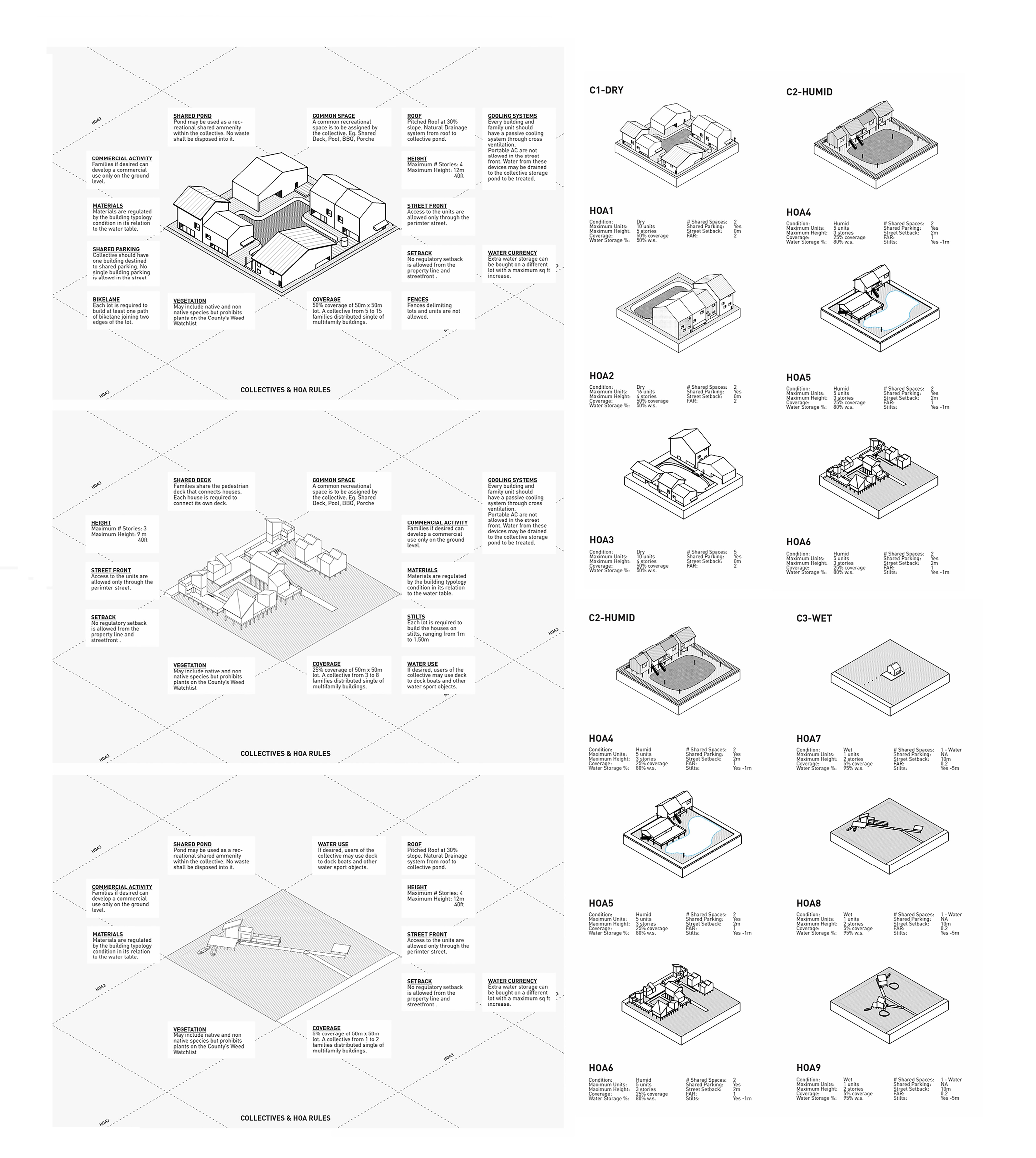
Study of novel zoning codes and Home Owner Association rules for the development of Planned Unit Developments on greenfield sites in South Florida. Image by Annie Ryan, Elaine Kim, Giovanni Bellotti, Alexander Wiegering Spitzer. (MIT Urban Design Studio 2016 – Masoud / Mazereeuw).
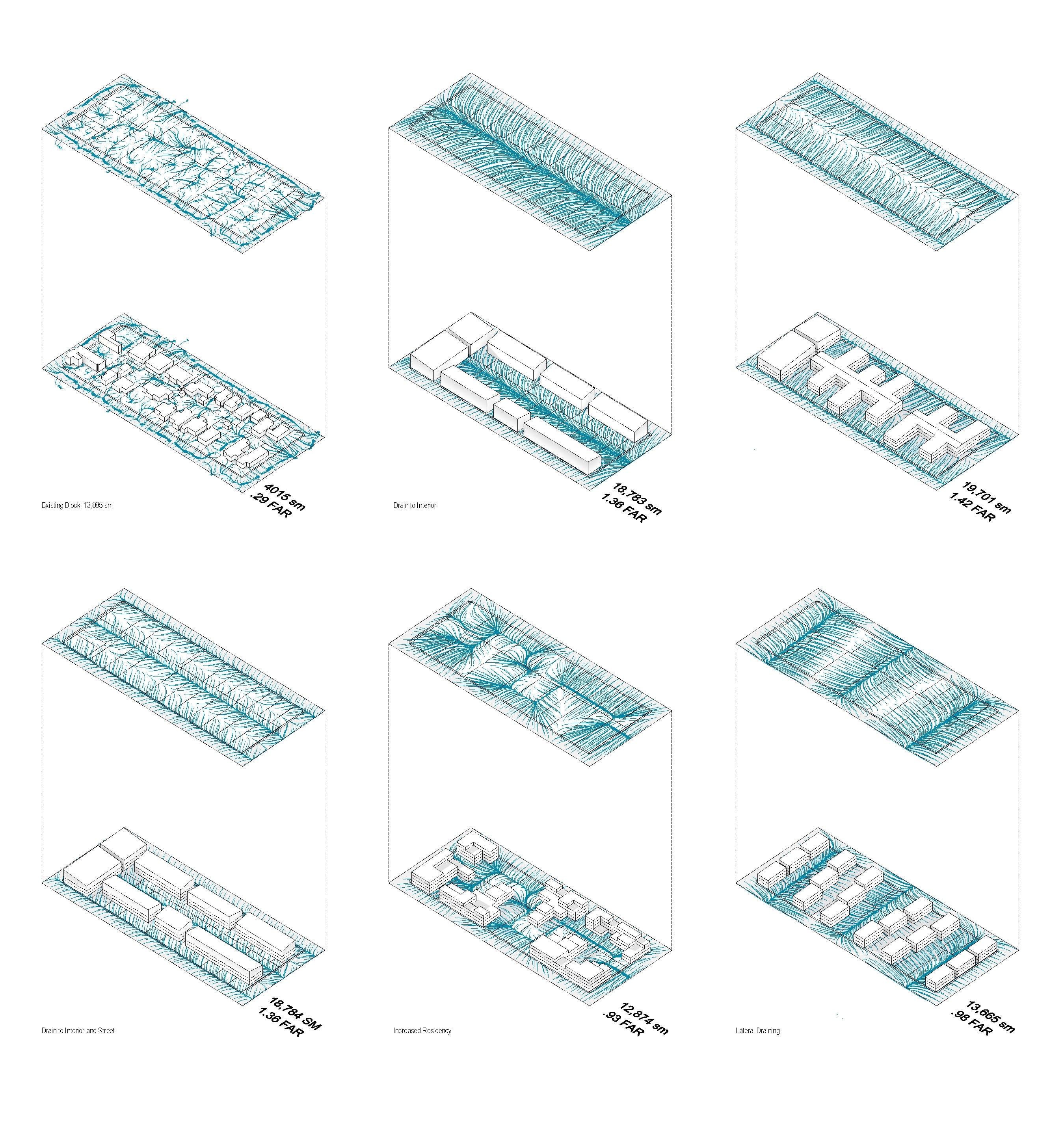
A study of built form aggregation as it affects storm-water drainage and the provision of open space. Image by Dennis Harvey, Pamela Bellavita Carvajal, Ranu Singh. (MIT Urban Design Studio 2016 – Masoud / Mazereeuw).
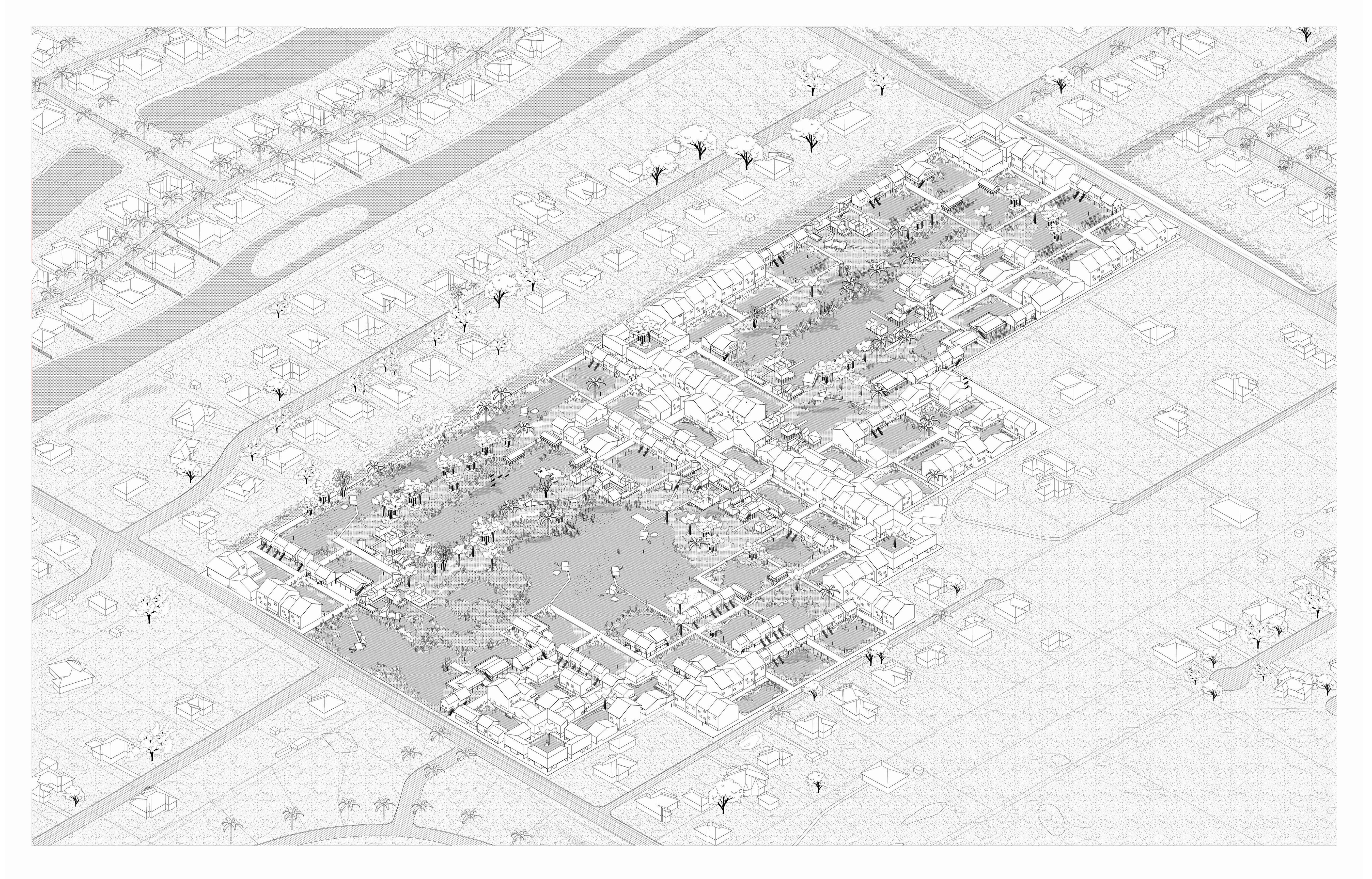
Potential application of novel codes resulting in new built form aggregation and planned unit developments on greenfield sites. Image by Annie Ryan, Elaine Kim, Giovanni Bellotti, Alexander Wiegering Spitzer. (MIT Urban Design Studio 2016 – Masoud / Mazereeuw).
King Tide Flooding in Fort Lauderdale (October 2016). Photo by Fadi Masoud.
Acknowledgments
The ongoing research presented in this paper is a collaboration between the MIT Urban Risk Lab’s Associate Professor Miho Mazereeuw and the University of Toronto’s John H. Daniels Faculty of Architecture, Landscape, and Design (Research Team Mayank Ojha, Aditiya Barve, Kelly Leilani Main, Ultan Byrne). The project started at The MIT Leventhal Center for Advanced Urbanism with guidance from Professor Alan Berger, Professor Adele Naudé Santos, and Managing Director Prudence Robinson. David Vega-Barachowitz (MCP’16) played a pivotal role in the foundational research and writing around planning and public policy. A special mention goes to Barbara Blake-Boy, Leonard Vialpando, Dr. Jennifer Jurado, and the team in Broward County’s Environmental Protection and Growth Management Department for their endless support and inspirational work in dealing with some of the most pressing urban issues of our time.
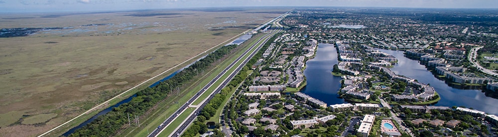
Header Image: East Coast Protective Levee. Photo Credit: Matthew Niederhauser and John Fitzgerald: Future of Suburbia Exhibition – MIT Norman B. Leventhal Center for Advanced Urbanism

Fadi Masoud is an Assistant Professor of Landscape Architecture and Urbanism at the University of Toronto. His research, teaching, and design work focuses on establishing relationships between dynamic large-scale environmental systems, landscape design, and the instrumentality of planning tools and codes. Prior to joining the John H. Daniels Faculty of Architecture, Landscape, and Design at the University of Toronto, he held teaching and research appointments at the Harvard Graduate School of Design and Massachusetts Institute of Technology’s Department of Urban Studies and Planning, where he taught design studios and seminars on urbanism, landscape, and visual representation.