STEPHANIE CARLISLE: How do you define migration?
ROLAND KAYS: Migration, from a movement ecology point of view, is the regular and repeated movement of an animal back and forth between two or more places. The classic example is seasonal migration in which an animal goes one place to breed and another place during the nonbreeding season. There is daily migration in animal populations, but generally biologists talk about seasonal migrations between North and South territories, up and down a mountain, from a dry place to a wet place, something like that.
NICHOLAS PEVZNER: Can you briefly describe your project, Movebank?
KAYS: Movebank is a free on-line archive of animal tracking data. It’s a tool used by animal tracking researchers to manage, share, protect, analyze, and archive their data.
Bird migrations in the Americas. Animation courtesy of Movebank and Bart Kranstauber.
PEVZNER: Can you tell us a little about your background and how you came to work on the Movebank project?
KAYS: I grew up in Michigan; I was a boy scout and liked to run around in the woods a lot. I studied biology at Cornell University and was interested in molecular genetics, but I spent a summer in the lab and found it really tiresome. I was drawn to field biology because at that point I really wanted to spend more time outdoors. Later I did a PhD at the University of Tennessee that involved running around the rainforest studying kinkajou, which is a raccoon relative that lives in the trees and only comes out at night. That work involved a lot of radio tracking: following animals around the forest listening to these beeps, catching little glimpses of the animals.
That’s when I started thinking there must be a better way to do this research. I met Martin Wikleski in 1996 and we cooked up an automated tracking system in Panama. We set up a series of six above-canopy towers, and had a system that automatically detected the signal of a VHF radio transmitter and estimated the direction to that radio collar. We then intersected the bearings from multiple towers to triangulate the animal’s location.
Wikelski and I designed this system to aid our own research. But once it was working, we realized it could be useful to other researchers so we made it available online. Right around that time, GPS tracking started becoming available for animal tracking. When that transformation in research methods happened, Wikelski and I already had a head start and were ready to deal with the big data problem that came along with the technology. GPS can transmit hundreds of thousands or even millions of images of locations per individual animal. At that stage researchers aren’t just thinking about data collection, but there is also an obvious need for data management tools as well. Movebank seeks to facilitate the data management and visualization side of this work.
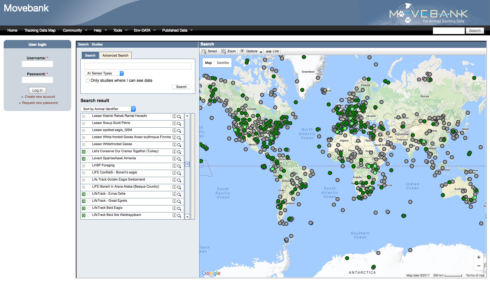
Movebank online interface. Image courtesy of Movebank.
PEVZNER: This seems like quite an undertaking. As the Movebank project has grown, what kind of scientists and technical experts were necessary for making the project possible? How do you all work together?
KAYS: For the most part Movebank is a collaboration between computer programmers and field ecologists. After the ecologists set up the studies, the computer programmers provide the link to bring in the data automatically from the SMS phone network or satellites. They organize and collate our content into a proper database over which each user controls access. The users can make the data easily available for other people to use, or they can lock it down to various levels and share it with specific users.
The primary end user is the field biologist catching and tagging animals, and then using Movebank to see and manage their data. The biologist has their own project they want to work on and they write their papers and address whatever questions they have. But their data is useful for all sorts of other projects. Movebank is now supporting comparative projects where researchers are grabbing data from multiple projects and combining them to ask new questions. This forms a second life of data through Movebank.
Another part of Movebank is connecting to global satellite data like weather, land use, human population, elevation, ocean currents; all this information is available with remote sensing. But it’s available in scattered, separate repositories, from NASA to the European weather forecasting center.
We’ve created a tool that allows a researcher to say, “OK, for my bird that migrated from Boston to Venezuela, show me the wind it encountered at each elevation as it flew.” And Movebank can fetch those data sets, and each point where the animal was it can tell the researcher the weather, how green the landscape was, the elevation, whatever variable. That’s the last part that we added and it was a lot of computing work and remote sensing satellite expert help.
Galapagos albatross flights relative to wind and ocean chlorophyll. Animation courtesy of Matthias Berger.
PEVZNER: How has tracking technology evolved during the course of the Movebank project? What is the ICARUS project and how does it relate to animal tracking?
KAYS: Since the 1960s we’ve been tracking animals with little radio transmitters. We call them pingers, or VHF tracking. This is where you run around with antennae and you tune into the radio frequency like you would a car radio, you hear where it’s coming from, and you can either walk up and try to find the animal or try to take two or three compass bearings and see where they intersect. And this is still used today because it’s cheaper and the devices can be smaller.
GPS became small enough to put on animals around 2008. There had always been limitations on size. GPS units are bigger than pingers and require more battery power, which determines what species you can put them on and the weight effect on that animal. The other part is you need a communication network to get this data back unless your animal is staying in a relatively smaller area, where you can recapture it to retrieve the data.
The first satellite that became available that allowed for automated tracking is called Argos. Initially it was used to locate the animals and it could go anywhere in the world and communicate data. But, in the 1980s pre-GPS, it got a fairly poor resolution of the animal’s location. Initially ARGOS was used to locate the animal and send the data back, and now it’s used to send the GPS data back. Now there are other satellite systems available: Iridium for phone calls and others that have been designed for satellite communication. And there’s also the GSM cell phone network, which is used by a lot of animal trackers, but it doesn’t cover the entire country. And, although the GSM units can be relatively small, they’re still not small enough, and are relatively power hungry.
To address this, we’ve been working on launching a new satellite that’s specifically designed for animal tracking, called ICARUS. Because it’s specifically designed for animal tracking, it’s optimized for low power, lightweight communication. And the antenna is being placed on the international space station, which is a low, earth-orbit satellite off of which it takes less energy to bounce a signal. ICARUS is trying to get the lightest weight, lowest power data transfer.

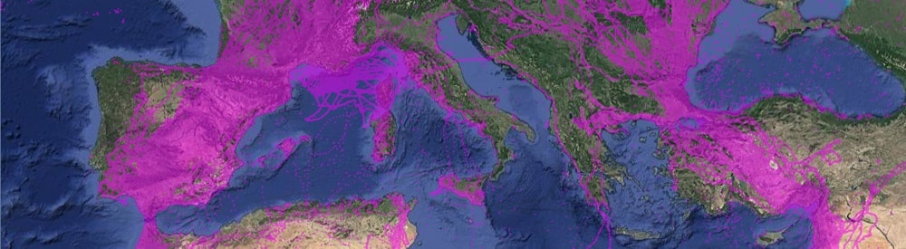
Density of publicly available animal tracks on Movebank as of May 2017. Image courtesy of Movebank.
PEVZNER: Very cool. And that allows you then to shrink the tag and therefore increase the range of species you’re able to study, right?
KAYS: Exactly. For example, we’re pretty sure bats have amazing migrations. We have an idea of where they start, but then they basically disappear. Smaller tags would make tracking flying animals much easier. The first generation ICARUS tag will be 5 grams and we’re aiming to get down to the 1-gram mark in 2-3 generations.
These smaller tags should dramatically expand the types animals that could be ear tagged. There are a lot of mammals that can wear big collars with decent sized batteries and it doesn’t really bother them. But you can’t put a collar on a young animal, because they are going to outgrow it. Juvenile dispersal, which is when a teenage animal grows up and leaves home and goes someplace new, is an incredibly important phenomenon that affects gene flow and habitat colonization, but we are limited in our ability to study it because we can’t collar those animals. In the future, we could give them an ear tag. Along with the physical tags, solar cells have also really come a long way. Bird tags with solar cells can last forever, if the bird sits in the sun. So it’s really freeing up the battery requirements.
CARLISLE: It seems like making this sort of data available to a broad community of researchers might open up new avenues for communication and question asking. Have you found any interesting or surprising studies that have come out of Movebank?
KAYS: The last couple of years we’ve really started to get a lot of data sets into Movebank so it’s a lot easier to collaborate that than it used to be. There’s more users and more data. There’s a group right now looking at climate in the arctic. They spent years researching and they’re now getting their data together to compare. There’s been other studies looking at flyways and at multiple different species that migrate, say from North America to South America. We have ideas that there are flyways based on what we see on the ground, but no one has connected up to see if they are flying along common ground. Those are two examples of studies that are underway. Combining across multiple years, multiple species, multiple different careers, they put it all together.
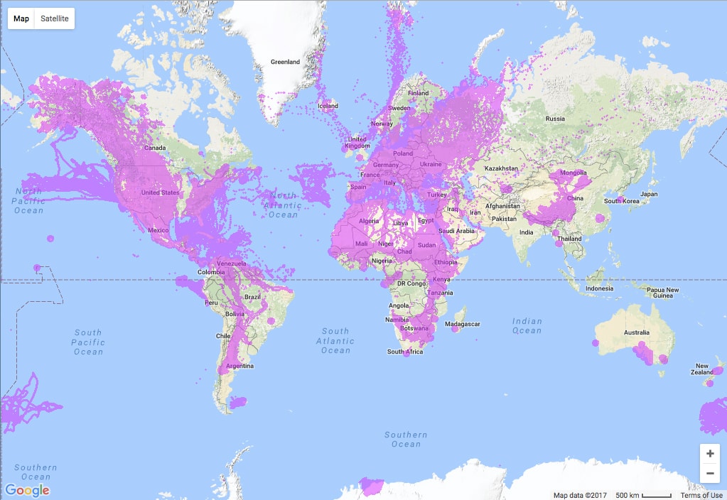
Publicly available animal tracks hosted on Movebank as of May 2017. Image courtesy of Movebank.
CARLISLE: I think it’s also very interesting that projects that set out to tackle a technical challenge often end up having social consequences. This project brings together researchers who approach the topic of movement and mapping from the perspectives of conservation biology, policy, climatology, or geophysical sciences. Do you think the project has opened up communication or collaboration between researchers?
KAYS: Well I think there are a few different flavors of collaboration. The first type, for example, is when all the different duck biologists come together and share their duck data with each other and start asking new questions about ducks. These are researchers that generally already know each other; they talk to each other and meet at conferences. But having a project where they are combing data to do something more is a new kind of collaboration. Movebank has definitely fostered some of those types of collaborations.
Another type of collaboration, more academic in nature, is when many researchers come together in a common project. I’m presently involved in a paper with dozens of co-authors. These giant collaborations can be more limiting, less intimate. You are primarily communicating with the lead author, and you know that they are trying to communicate with 59 other people, and so you try not to overwhelm them. Sometimes it’s important to get information directly from collaborators who really know their species and the nuances of their own data. But, it’s probably the lead scientist and two or three other people in her lab having that more meaningful collaboration.
The last type of collaboration is perhaps more complicated and more difficult to predict how it will play out. For example, we’ve had computer scientists who are just interested in movement. They don’t really care what it is that’s moving around, they just want to study movement and develop new analytical tools for that behavior. There haven’t been many platforms to facilitate access to that sort of data. Another example is storytellers interested in using the data in very different ways. There is a book that recently came out called Where the Animals Go that used data from Movebank to make an atlas of animal movement and tell the stories of the animals from the data set.
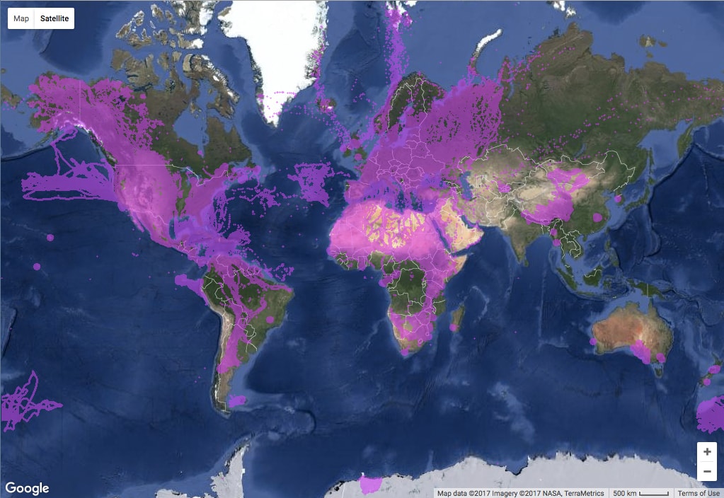
Publicly available animal tracks hosted on Movebank as of May 2017. Image courtesy of Movebank.
CARLISLE: For a lot of architects and urban planners, the behavior of wild animals and the insights of conservation biologists may seem a little distant from their work in cities. Urban ecology has provided some useful ground to talk about the connections between the built environment and ecological systems. How might the study of animal migration help designers think differently about urbanization?
KAYS: Well, one topic that ties these issues together is animal movement corridors. There are cases where animals need to move from A to B, whether it’s seasonal or daily migration. In fragmented landscapes such as most developed areas, you have a forest that might not be big enough to hold a particular animal, not enough habitat. But if the forest connects with another patch, the animal is able to move between those and has enough space. Maintaining the connectivity for these animals is super critical. So designers need to understand if animals use corridors, what type of corridors they use, what makes a good corridor, and how can we mitigate barriers such as roads using underpasses or overpasses. At all sorts of different scales, whether you’re talking about different patches of urban forest that you would put together to make a decent home range for an animal, or whether you’re talking about regional migrations, it’s this idea that maintaining corridors for animals will help them survive better. Animals species are dynamic, not static. They are changing.
PEVZNER: I would assume, from a conservation perspective, that having a better understanding of how animal communities and populations are moving in the present day would help provide insight into how animal populations might be impacted by future development or other changes, like climate.
KAYS: One of the things I find interesting is seeing how a species has changed over time. In North America we have a lot of species moving into the built environment and adapting. For example, we did some work on fishers that used to be considered old growth specialists but that are now living in suburban Boston and suburban Albany.
There are some limitations to adaptation. You’re not going to drop a wolverine into Central Park and have them survive. There must be a decent population size for that to happen in the first place. You must have protection from hunting to the extent that the population can have the variation for adaption to the built environment for evolution to act on.
CARLISLE: I can imagine that over long periods of time, this data would provide interesting documentation of range expansion and help researchers test how flexible an animal species might be. But, I suppose that in making the jump from individuals to populations, you’d need to tag a lot of animals, wouldn’t you?
KAYS: That’s really becoming an important question now that we are collecting so much data on individuals. We can characterize what an individual is doing and compare across individuals and start to measure population dynamics. But, then the question is how much do individuals vary, and how many individuals do you need to study to get a good characterization of the population? Quite often we find animals are doing different things in the population. We already knew it was an important question but we were not able to quantify how important it is; now that we have this tool it’s beginning to let us see what animals are doing in detail. That’s a very active area of research, but there’s no summary results yet.
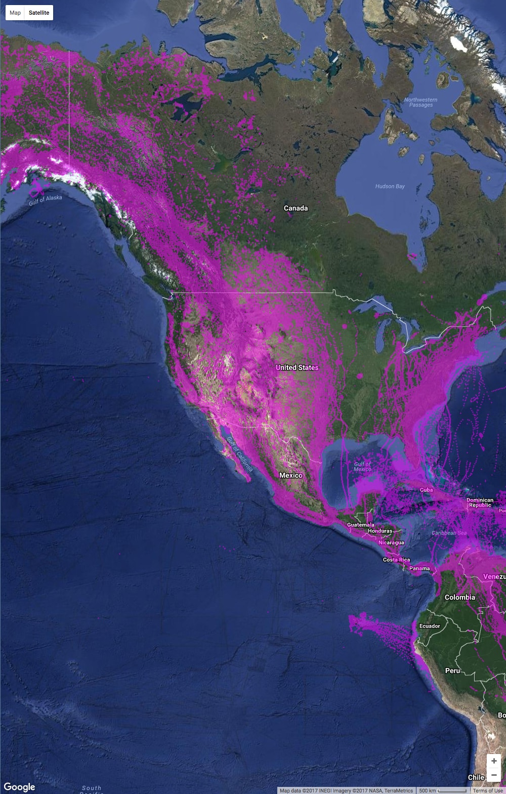
Publicly available animal tracks in North and Central America. Image courtesy of Movebank.
PEVZNER: Are there different kinds of questions that tracking land animal movement raises as compared to, say, bird migrations, which can range over a much larger territory?
KAYS: I don’t know if they’re different questions, but certainly the scale of asking is different. The options are different. The movement ability of these animals is different. I’m tracking a bald eagle that flew 100 km from Virginia to Pittsburgh yesterday. No land animal can do that, yet the eagle probably soared on thermals and barely spent any energy. If global warming is changing where his suitable habitat is, he’s going to be able to find it a lot easier to move than a porcupine on the ground that has a small home range and can’t get around.
CARLISLE: It’s making me think again back to the animations and maps that Movebank produces. The visualizations of various scales of migration projected across the globe are really incredible. But these global maps can also seem pretty abstract. Your stories are reminding me that at the end of the day, every individual or path on the map is indeed an animal that someone went to in the field, tracked, caught and tagged. It’s not just a dot.
KAYS: That’s the hardest part.
CARLISLE: Does working with these large data sets make the research seem more abstract?
KAYS: It’s actually much less abstract. Like with this eagle, I wasn’t even there when he got tagged. But, I get an email update every day, and I check and see where he is. He has been hanging out on this garbage dump for the last three weeks in West Virginia. And I called up the dump and asked about him, and they’re like, “Oh yeah, we see him up here, he sleeps, hangs out on the edge, feeds.” I was curious if he was eating the garbage and they said he mostly hangs out in the grass and feeds. I’ve been following this animal since he was released in July. We have tens of thousands of points now and it’s must less abstract, much more concrete and involved.
CARLISLE: Does it change your relationship to the animals you study?
KAYS: Yes, it’s a much richer relationship. It’s very much a one-way relationship and I’m following his every movement.
CARLISLE: Maybe you should tag yourself and give him a little monitor to watch your movements.
KAYS: (Chuckling) You know, what I really like to do is download the data from an animal and then go back and walk in their footsteps and see what they’ve been doing. We did that in our project in Panama. It’s fine to look at movement data and say “…and the animal was sitting here for three hours,” but what was he doing? When we go to the exact location, we look around and find a fruit, figure out what he was eating, and learn about the routes he uses to move about.
We also did that with fishers in New York, where we could see exactly what they were doing by going there shortly thereafter and finding their footprints in the snow. There’s a lot of different ways this allows you to learn quite a bit more of the animal rather than just looking on Google Earth or going outside and retracing their steps.
You should check out the Animal Tracker app. You can follow Freedom the eagle now —the guy who moved from West Virginia… I think there are also a few Osprey and some other interesting birds on there. Animal Tracker is how we give some of the data away free, live, and in real time. And we think people probably aren’t going to go and try to shoot the bald eagle.
Bird migrations in Eurasia. Animation courtesy of Movebank and Bart Kranstauber.
 Dr. Roland Kays is the head of the Biodiversity Lab at the North Carolina Museum of Natural Science and a Research Professor in the Fisheries, Wildlife & Conservation Program at NC State University. Roland is interested in how, where, and why animals move, and his research typically involves bringing the latest technology into the wild parts of the world to discover new things. His work has allowed him to explore tropical rainforests, African savannas, and suburban woodlots. He was co-discoverer of the olinguito, a new species of mammal from Ecuador and is the co-founder of the Movebank animal tracking database and the eMammal camera-trapping database. Roland is the author of the Princeton Field Guide “Mammals of North America” and has a new book “Candid Creatures: How Camera Traps Reveal the Mysteries of Nature”. Dr. Kays received his BSc degree from Cornell University (1993) and his PhD from the University of Tennessee (1999).