Introduction: Migration

Populations move. Plants disperse genes by way of seeds and pollen; wetlands accrete and erode; animals forage, mate, roam. Humans leave their homes in search of work, land, education, safety, and opportunity. Migration is a process by which organisms track resources, discover, and escape. The patterns of migration reflect spatial and temporal changes in the landscape. Migration is a cipher and a signifier — it helps us unravel the invisible threads that hold together an ecosystem.

Broadly speaking, migration can be defined as “the mass directional movements of large numbers of a species from one location to another” [1]. The term is used to describe a diverse array of patterns, from the intercontinental movements of Arctic terns and humpback whales to the micro-movements of tiny shore animals following the tidal cycle. Migration plays out over time, across scales, and in specific geographies.

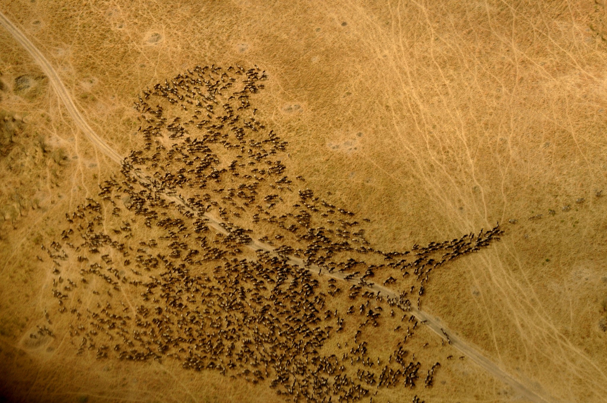
Photo by T. R. Shankar Ramanhandel


Biologists and population ecologists often focus on seasonal, round-trip movements between discrete locations. Such seasonal migrations are essential to the survival and resilience of many populations, as communities respond to changes in resource availability or habitat quality over the course of the year. For some long-lived species, individuals make the journey between winter and summer ranges year after year. For others species, such as the painted lady (Vanessa cardui) or monarch butterfly (Danaus plexippus), migrations can occur over multiple generations, with one individual incrementally following the shifting season and accompanying resources northward or southward, then passing the baton to its offspring to continue the journey.

For humans too, migration is a basic survival strategy. Humans have always moved, and often over very long distances [2]. The large-scale movement of people goes back more than a hundred thousand years when early homo sapiens began migrating out from the African continent. Just as other species migrate in reaction to resource availability, habitat quality, and stress or disturbance — human populations move (voluntarily or involuntarily) for a wide range of motivations.

Migration, therefore is a broad construct that can describe flows of populations as diverse as the seasonal patterns of migrant laborers and nomadic herders, the relocation of populations in response to earthquakes or civil wars, the zealous journeys of missionaries or explorers, the voluntary seasonal travel of retirees, or the involuntary removal of populations ensnared by mass incarceration. The framework of migration studies has also been used to study complex and traumatic histories such as the forced migration resultant of ethnic cleansing or the transatlantic slave trade. These large-scale movements of individuals and communities from one location to another, or one way of life to another, is now recognized as having far-reaching effects on culture, language, genetics, law, economics and the environment.

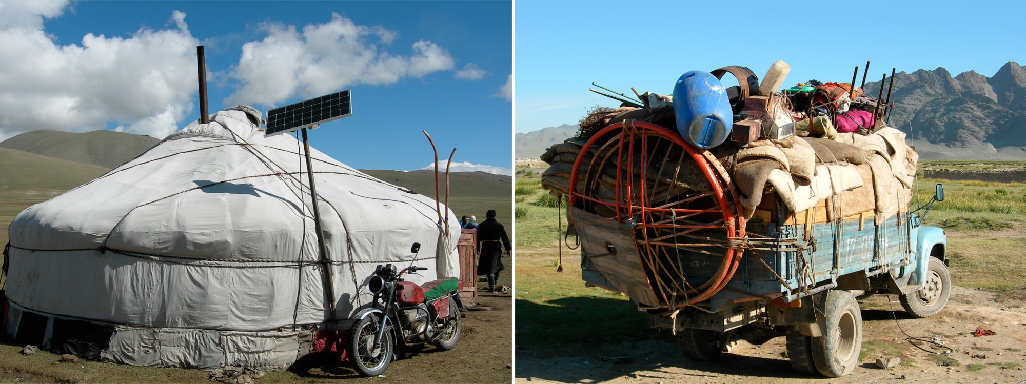
Nomadic ger disassembled and loaded in just a few hours in the countryside outside Ulaanhus Soum, Bayan Olgii, Mongolia.  A single truck was sufficient to carry two families’ belongings including two gers, furniture and stoves. Photograph by Stephanie Carlisle

International Migration

The total number of international migrants today is estimated by both the United Nations 2015 Migration Report and the Pew Research Center at 244 million, or roughly three percent of global population — the highest number of people on the move ever recorded, and a 41% increase compared to the year 2000 [3]. Over 65 million people are forcibly displaced from their homeland, and nearly 20 million of those individuals are refugees [4]. Conflict, injustice and systemic violence are not new to history, but today’s ongoing crises and inequalities occur amidst a context of increased human mobility, globalization and interconnectedness.

Nations hosting large refugee populations bear a disproportionate burden as long-term responses to crises around the world remain “ad-hoc, incomplete and uncoordinated,” according to the United Nations Summit for Refugees [5]. Furthermore, the impacts of large-scale movement of refugees and migrants, are felt at every point across the diverse landscapes that serve as places of origin, transit, or destination. In pursuing a better life, migrants take incredible risks and travel at great expense. In their countries of destination, the arrival of foreigners in large numbers have been met with the full spectrum of human emotions and actions — from deep solidarity and charity to racist protest and a sharp uptick in hate crimes and discrimination.

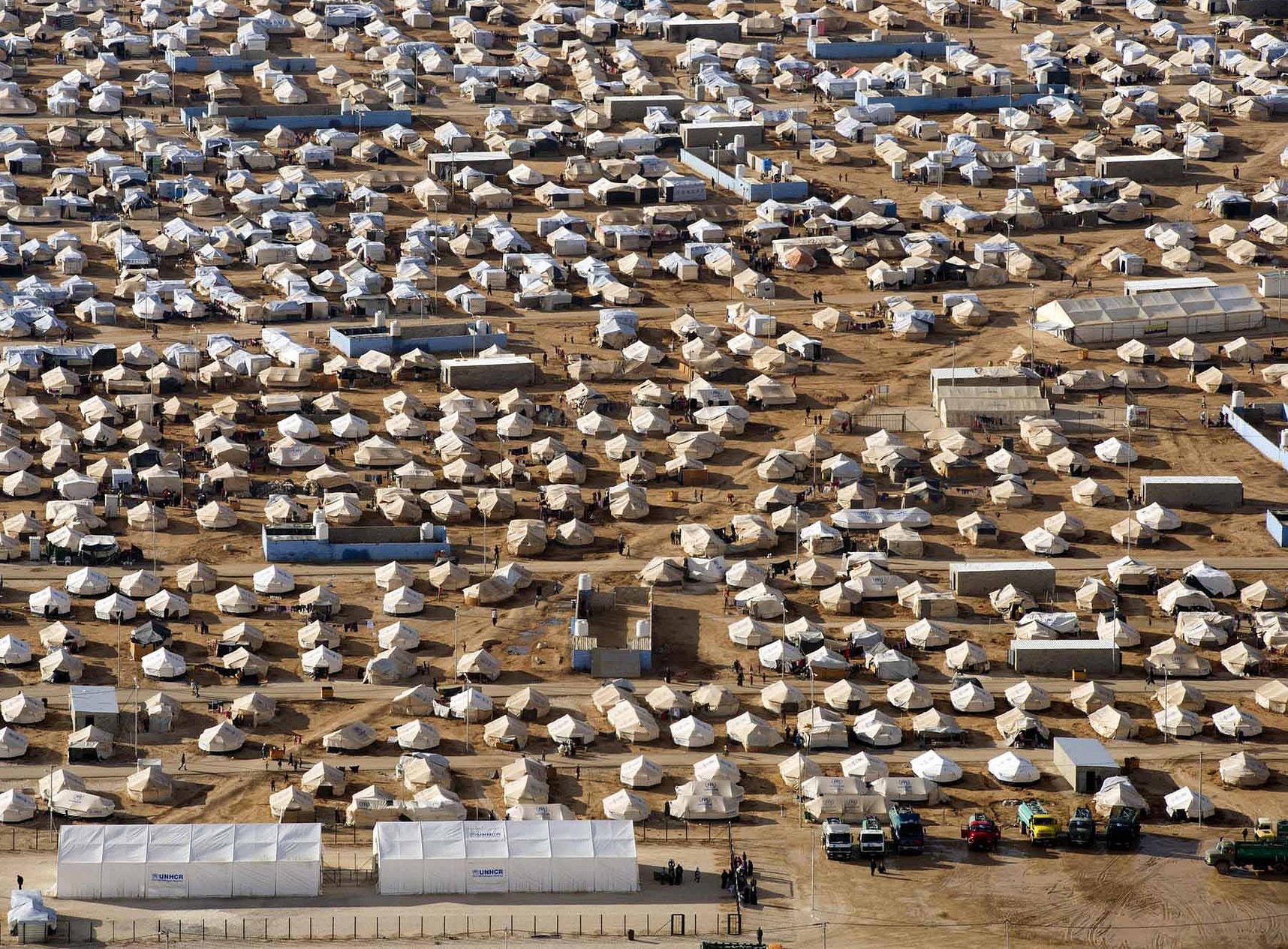
An aerial view of Za’atri refugee camp near Mafraq, Jordan. Photo by United Nations Photo


Rural to Urban Migration

China, meanwhile, is hosting what may be the largest internal mass migration in history. According to Kam Wing Chan, professor of geography at the University of Washington, over the last three decades, over 200 million rural Chinese have moved from the countryside throughout inland China to the rapidly growing industrial and financial urban centers on the coast, such as Guangzhou, Beijing, and Shanghai [6]. These migrants are not foreigners in their new homes and don’t often evoke the same narrative of diluting national identity, but they have brought with them new challenges of social transformation, and have fueled demand for a massive expansion in infrastructure, in housing, and in other government services. Rapid urbanization in China, fueled by rural migrant labor, compulsory resettlement programs, and the arrival of manufacturing from around the world, has created its own suite of social and ecological challenges.

New urban development in Chongqing, China. Photo by Thomas Bächinger


In retrospect, such migration events often have the effect of injecting cultures with diverse and hybrid elements, forging new ideas and cultural innovations in the places they settle. America’s Great Migration is one such example, in which close to 6 million African Americans moved from the predominantly rural South between Reconstruction and the 1970’s to the growing northern and western cities of New York, Philadelphia, Chicago, Los Angeles and Detroit, to name a few [7]. Isabel Wilkerson, the author of The Warmth of Other Suns, describes the first steps of the Great Migration as the accumulation of millions of individual decisions, which nonetheless set into motion a profound reshaping of American life and culture, ultimately transforming the character of cities, music, art, politics, and community dynamics [8]. At the same time, the movement of black and brown people into largely white cities created new tensions and conflict, giving rise to the creation of urban ghettos, exclusionary zoning, institutionalized discrimination and white flight to suburbs — urban dynamics whose legacies are still with us today [9].

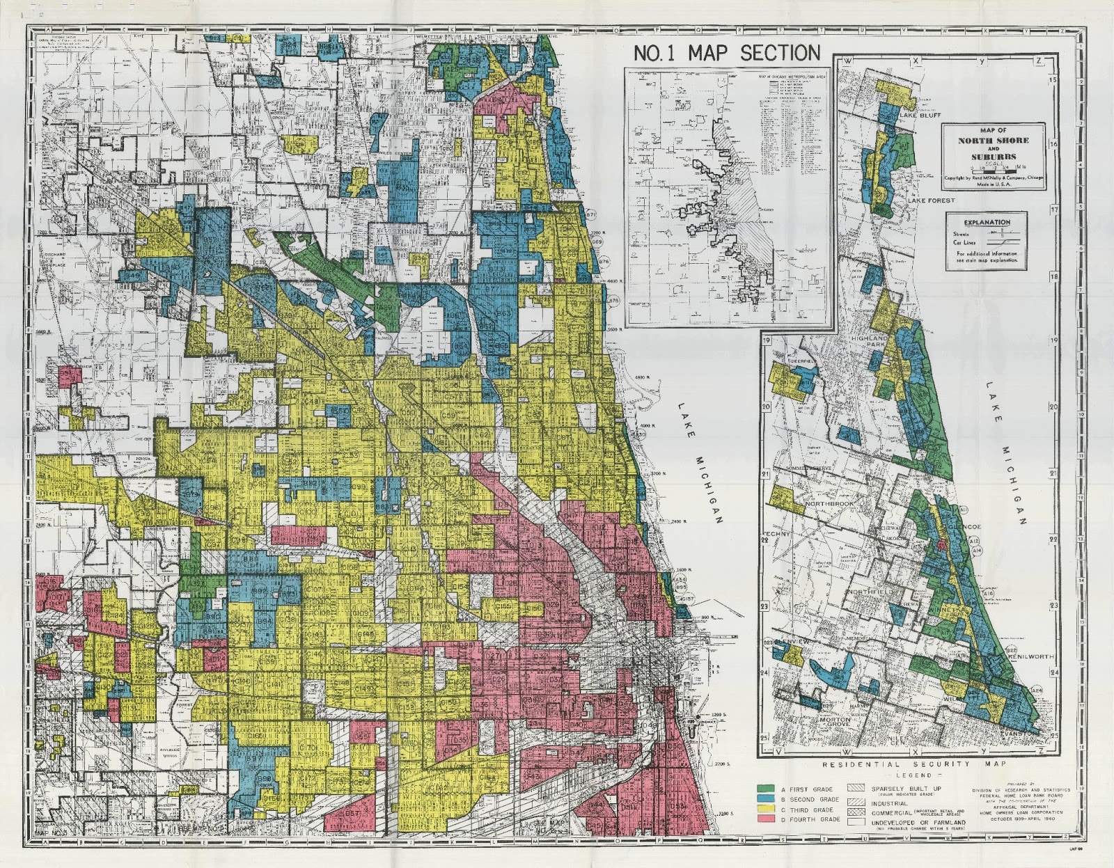
Home Owner’s Loan Corporation Redlining Maps of Chicago, 1939. Green = “Best”; Blue = “Still Desirable” ; Yellow = “Definitely Declining” ; Red = “Hazardous”


Language and Anxiety: how we talk about migration

Migration is a fundamental process that sustains communities, but it also represents our greatest social anxieties. As such, it has become difficult to speak of migration of any sort without entering a semantic minefield. Today, the language of migration is political; perhaps this has always been the case. The words that we use to talk about migration matter and the language of migration is constantly shifting [10].

Migrant, emigrant, immigrant, asylum seeker, refugee, alien: these are all official categories [11]. Recently, the perceptions of these words in politics and popular media have become more negative. According to Dr. Emma Bryant, a researcher who specializes in propaganda, migration, and media studies at the University of Sheffield, “negative associations with these categories really do cloud how we analyze the facts. The important takeaway is that including context about why people are traveling and trying to see them as human beings that are affected by social and economic pressures and political transitions that are taking place around the world is the key issue” [12].

The words we choose matter. Bryant also points to linguistic trends commonly used to disparage or marginalize people, such as the tendency to borrow the language of natural disasters or the apocalypse — deluge, flood, swarm, waves, parasites — which has the double effect of amplifying fear while also dehumanizing people.  Additionally, the lens of race and class also affects the words we use in conversations about migration. Brits that retire to Spain or go to Saudi Arabia to work for the oil industry tend to refer to themselves as “expats,” not migrants. In popular media, “migrant” is primarily applied to outsiders, to people with a different skin color, religion or socio-economic status than the majority group. For further emotional effect, the word “illegal” is often added as a modifier of someone’s status when nothing illegal at all has happened [13].

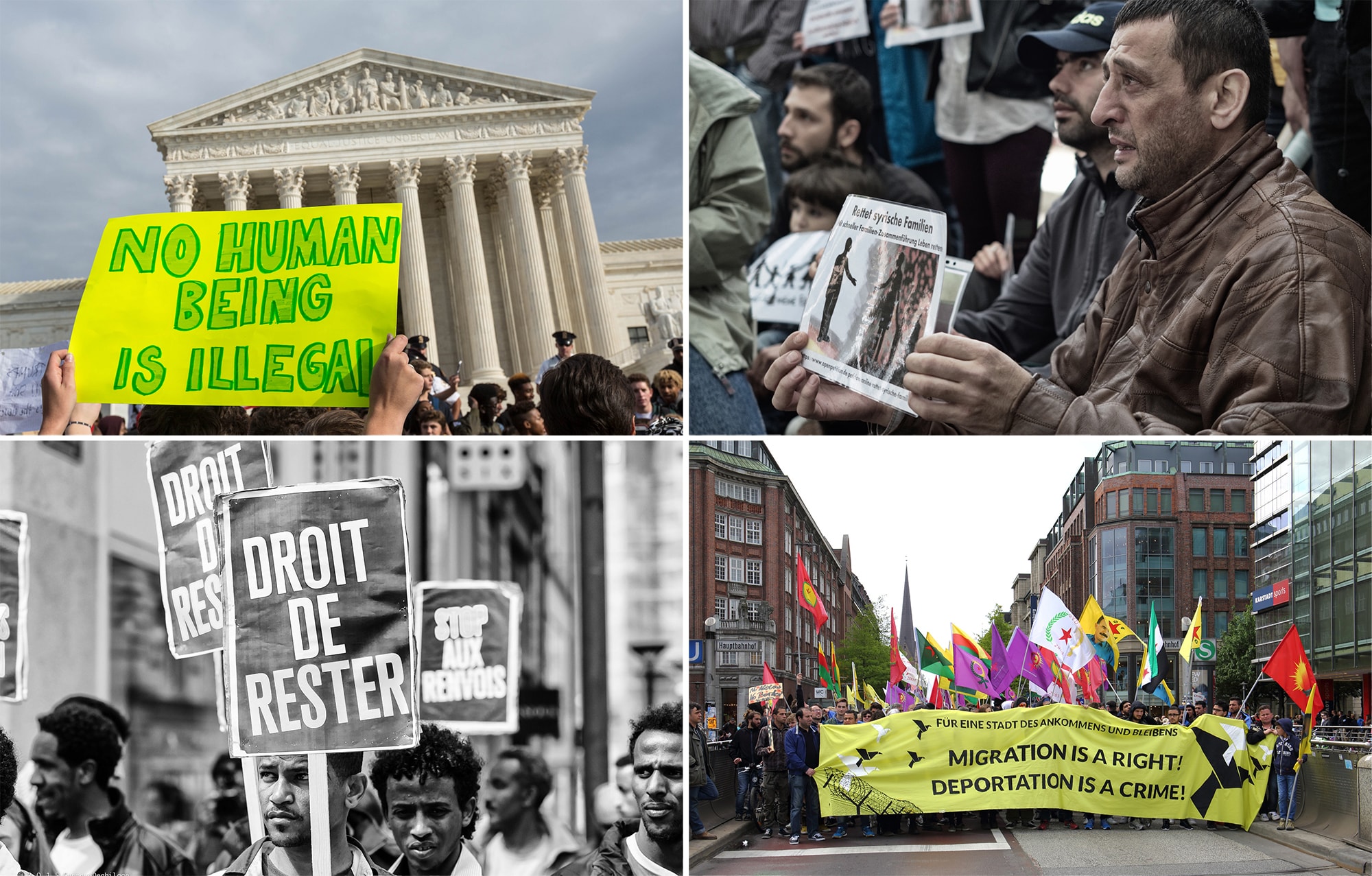
Clockwise from top left: U.S., 2016; Berlin, 2016; Hamburg, 2016; Lausanne, 2015. Photos by Lorie Shaull; Majka Czapski; Rasande Tyskar; Gustave Deghilage


Curiously, the language of migration and social anxiety has even seeped into the natural sciences, igniting fierce debate. In June 2011, a group of ecologists published a short paper in the journal Nature, titled “Don’t judge species on their origins,” in which they argued that the threat posed by alien or exotic species have been overstated and that the field of invasion biology draws from the flawed and problematic notion that a “native” condition can and should be restored [14]. The article drew from ecologist Mark Davis’ ongoing critique that the words that ecologists and conservationists had adopted, to much effect, had become counterproductive, going as far as to argue that “classifying biota according to cultural standards of belonging, citizenship, fair play, and morality does not advance our understanding of ecology” [15].

By July 2011, several fiercely written commentaries and op-eds were published in the journals Science and Nature, on behalf of hundreds of biologists, conservationists and environmental managers, fiercely disagreeing with the premise of Davis’ piece, offering well-reasoned perspectives and insight into conservation practice, defending their field of study, but also continuing to use terms that explicitly reference the language of nativism, policing, surveillance, and crisis [16].

It’s not that scientists just disagreed about the careful introduction of species and the creation of novel assemblages — it was in large part the explicit reckoning with language that was so contentious [17]. The debate has led to the surreal spectacle of conference rooms filled with tenured ecologists and evolutionary biologists arguing over whether or not foundational terminology used to describe flora and fauna is xenophobic. How did we get here?

According to some researchers, what may connect these fierce debates over the language of migration, be it human or non-human, are pervasive societal feelings of a loss of control, a lack of certainty about the future, a sense that the world is changing far too quickly, that old modes of making sense of our environment might no longer be valid. Scientists Paul Robbins and Sarah Moore from the University of Wisconsin-Madison pointed to the debate over Invasion Biology in 2011 as emblematic of “Ecological anxiety disorder,” which they believe is fundamentally a response to rapid environmental change and the rise of novel and unprecedented ecosystems that “challenge the scientific, as well as cultural core of many disciplines” [18]. Perhaps the clearest trigger of this anxiety is the concept of the Anthropocene.

Similar emotions can be found lurking beneath other theories that have more recently made their way into popular science, such as the Great Acceleration, the Sixth Extinction, novel ecosystems, extinction debt, and the specter of irreversible climate change connecting them all. The underlying notion is that the relationship between man and nature has fundamentally changed and that despite our species’ newly recognized power, we don’t seem particularly in control.

Despite the care we may exercise with our words, our landscape management practices, our immigration policies, or our urban infrastructure, ever more migration can be anticipated — of species, of habitats, and of human populations. The questions for society are open-ended and challenging.

What will be the appropriate level of intervention?

Which communities are “worth saving”?

What exactly is the value of “native” species or a “natural” state?

Are we trying to Make Nature Great Again?

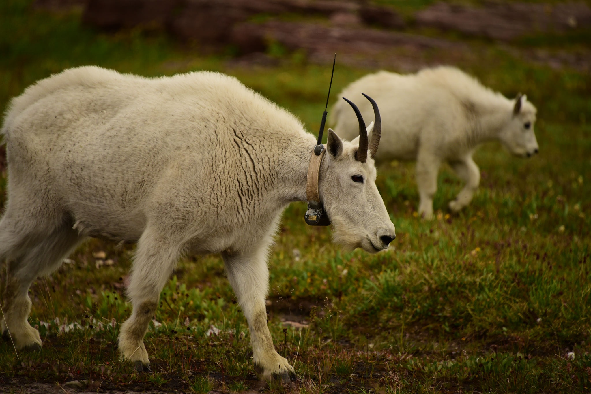
Mountain goats in Glacier National Park. Photo by Tom Driggers


Connectivity, Visibility, and Barriers

Migration relies on complex networks of relationships that can easily be damaged or disturbed. Over time, well-established movement corridors become blocked. Barriers can take on a range of forms, often innocuous in their own right but potentially devastating to a population’s ability to migrate: roads and fences severing seasonal migration routes that animals have relied on for hundreds or thousands of years; dams blocking fish from returning to their spawning grounds [19]. The disappearance of coastal wetlands due to urban development and sea level rise disturbing the tenuous network of stopover grounds that long-distance migratory birds depend on to feed and refuel on their way south or north. Beachfront development restricting the natural migration of sand dunes and wetlands, a phenomenon memorably known as “coastal squeeze.”

Other times, barriers are intentionally erected. In response to the social anxieties sparked by large-scale immigration, some countries are putting up new border walls and fences, a physical manifestation of the unwelcome borne towards migrants.

These barriers are explicit agents of violence. Still, migrants seek out paths of opportunity and least resistance. Thus, as land routes from the Middle East and Africa to Europe were systematically closed off in Greece, Bulgaria, Hungary, Slovenia between 2012 and 2015, many more migrants took to the sea, knowing the risk but choosing to continue moving [20]. At the U.S.-Mexico border, the consolidated flow of migrants formerly concentrated at border towns like Nogales and El Paso has been impeded since 1994 by steel walls and increased enforcement [21]. As a result, migrants and refugees have been pushed further out into the harsh landscape of the Sonoran desert.

In The Land of Open Graves: Living and Dying on the Migrant Trail, anthropologist Jason De León argues that “migrants have been purposefully funneled into the desert through various enforcement practices, a tactic that has enabled Border Patrol to outsource the work of punishment to actants such as mountains and extreme temperatures” [22]. The resultant death toll has been severe. By conscripting landscape to be the enforcer and agent of violence, governments can claim plausible deniability, avoiding the moral outrage and bad optics of personally killing thousands of people upon their country’s doorstep.

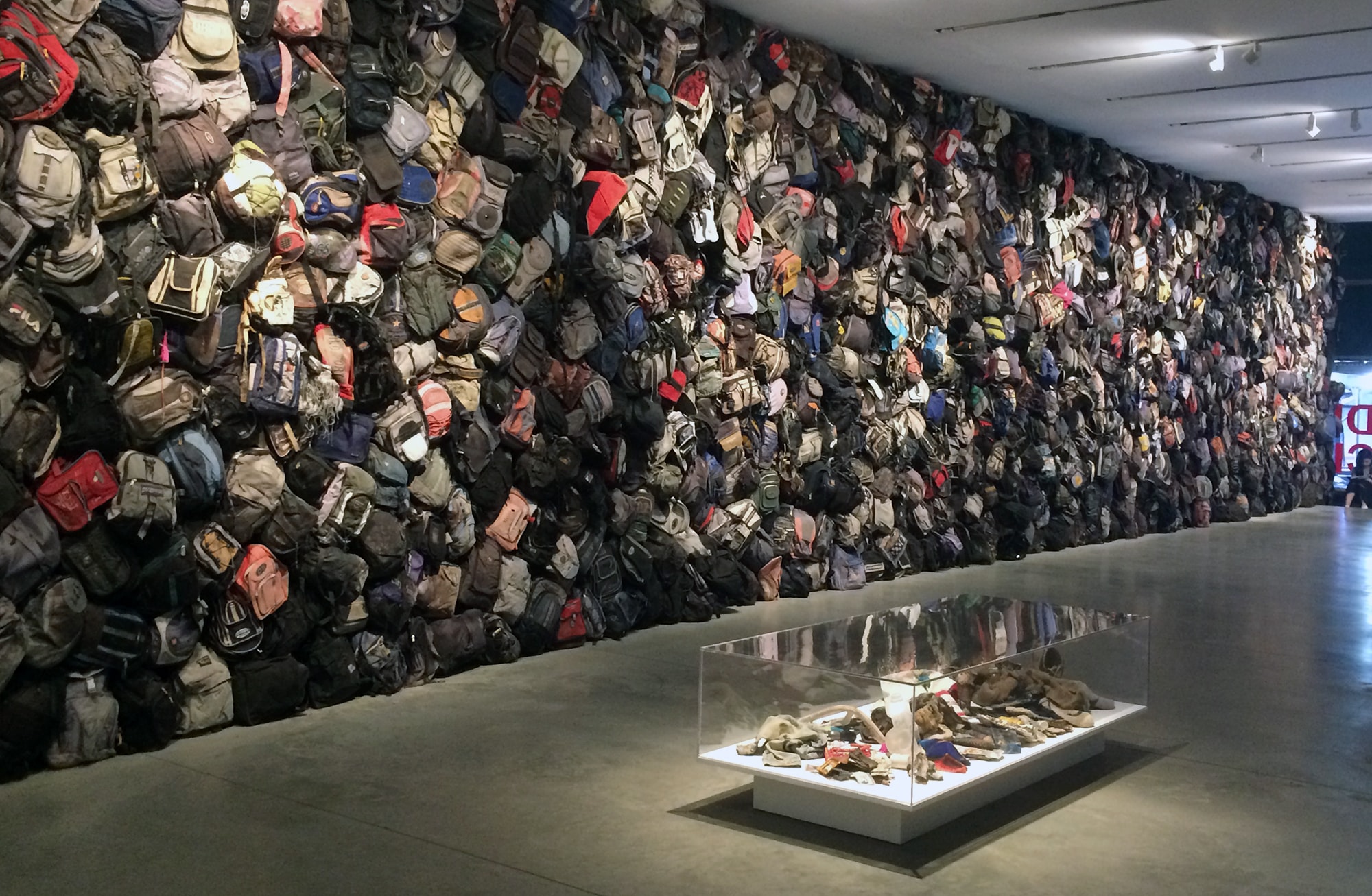
Installation of hundreds of backpacks abandoned by migrants crossing the Sonoran desert, part of the exhibition State of Exception/Estado de Excepción created by artist/photographer Richard Barnes and artist/curator Amanda Krugliak in collaboration with anthropologist Jason De León. Photo by Nicholas Pevzner


Is promoting connectivity always the answer? In some places, the newfound connectivity of international shipping and air travel has enabled invasive plants and animals to spread, making native populations more vulnerable to invasion. On formerly remote islands, waves of non-native plants and animals have caused local extinctions. Infections spread much more extensively and quickly in our connected world. The design of our cities and landscapes can either facilitate or inhibit migration. Which flows do we want to encourage, and which to block?

As habitats shift in response to global climatic changes, and development patterns push up against long-established migration patterns, some of which are coming into focus for the first time, how can cities and infrastructure be designed to be more mindful of these flows? How can populations on the move keep up, and what kind of assistance can designers, planners, land managers, and restoration ecologists offer?

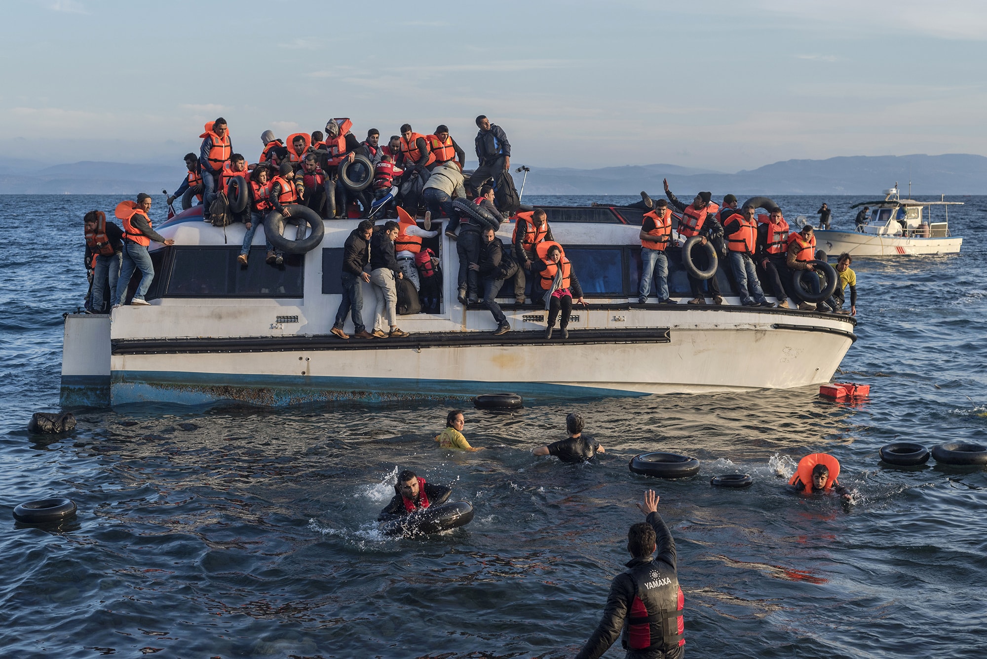
Syrian and Iraqi migrants arriving in Greece. Photo by Ggia


The Essays

This past year, hardly a week has gone by in which the topic of migration has not been in the news, or in which a new study on the effects of migration has not been published. This year, both Science and Nature ran special issues on Human Migration. The Economist included a special report on the topic, numerous academic journal devoted thousands of pages for specialized and focused perspectives on migration [23]. Last year, the United Nations General Assembly hosted its first high-level summit to discuss large movements of refugees and migrants and plan a coordinated global response [24]. The World Economic Forum’s Global Risk Report mentioned the global migrant crisis as one of the top five drivers of risk and uncertainty in the world for three years in a row [25].

It has made the curation and editing of this issue fraught, albeit timely, as month after month, another national election, “natural” disaster, or geopolitical event has thrown the topic back into the spotlight. It is simply not possible to fully explore the richness and intricacies of this topic in fourteen pieces. Instead, in this issue of Scenario Journal, we have brought together a few stories that explore select facets of the complex story of migration, told from a range of disciplinary perspectives.

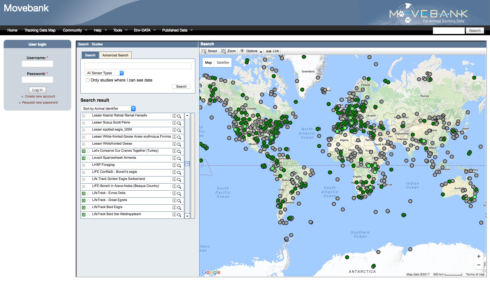
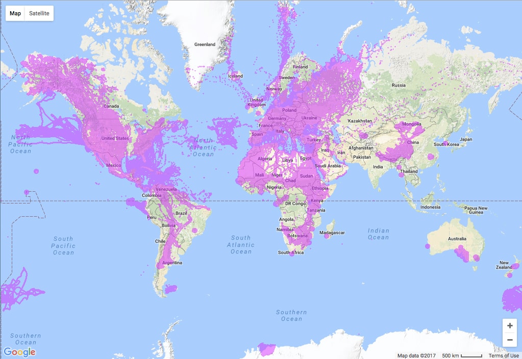
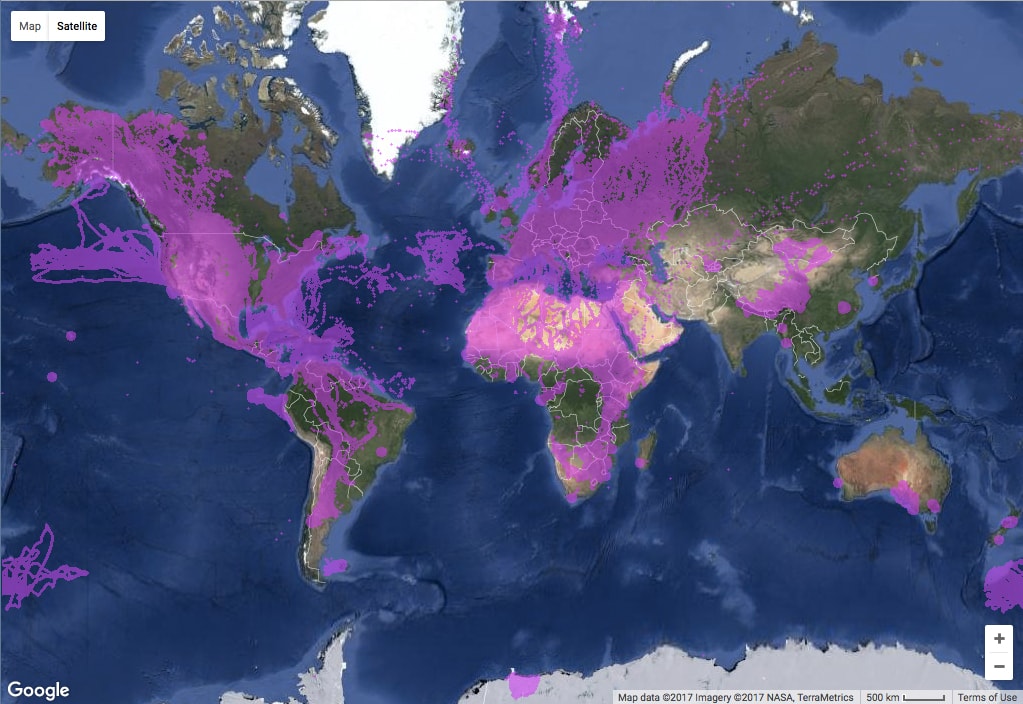
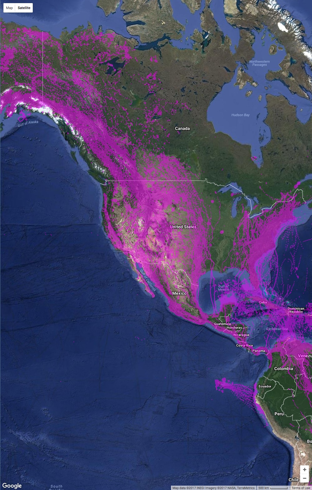
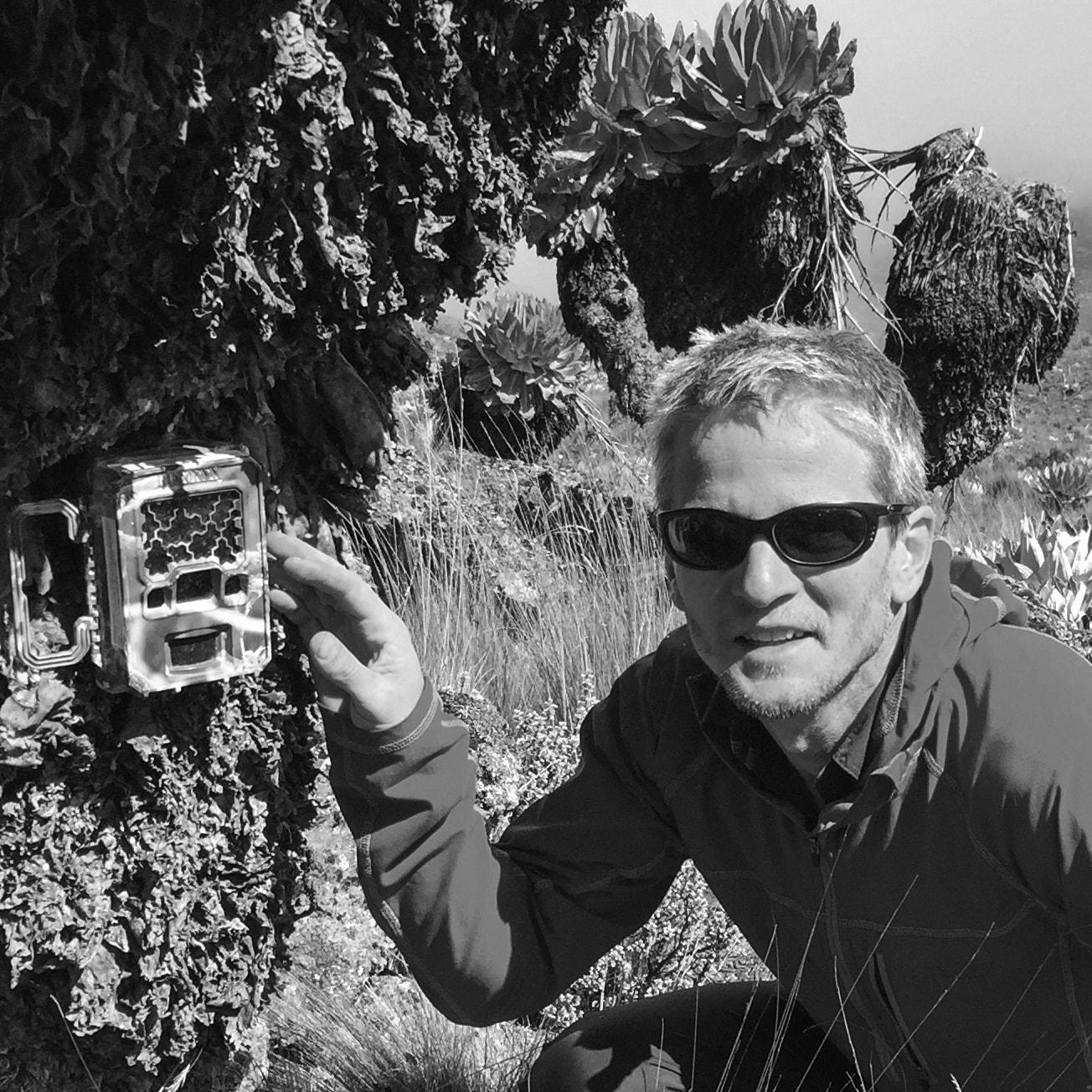
Grounding the discussion in the natural sciences, we have an overview of migration processes by restoration ecologist Steven N. Handel, spanning the widest range of scales and time frames, from the march of species across continents to the micro-movements of rhizomes along the forest floor. In the face of pressure from migrating habitats, he unpacks promising and controversial ideas like “assisted migration,” while articulating the limits of this form of “extreme gardening.” Meanwhile, Roland Kays discusses the challenges of studying animal migration in the field, and the fascinating technological advances that are allowing researchers and the public to see many animal trajectories at high resolution, some for the first time.

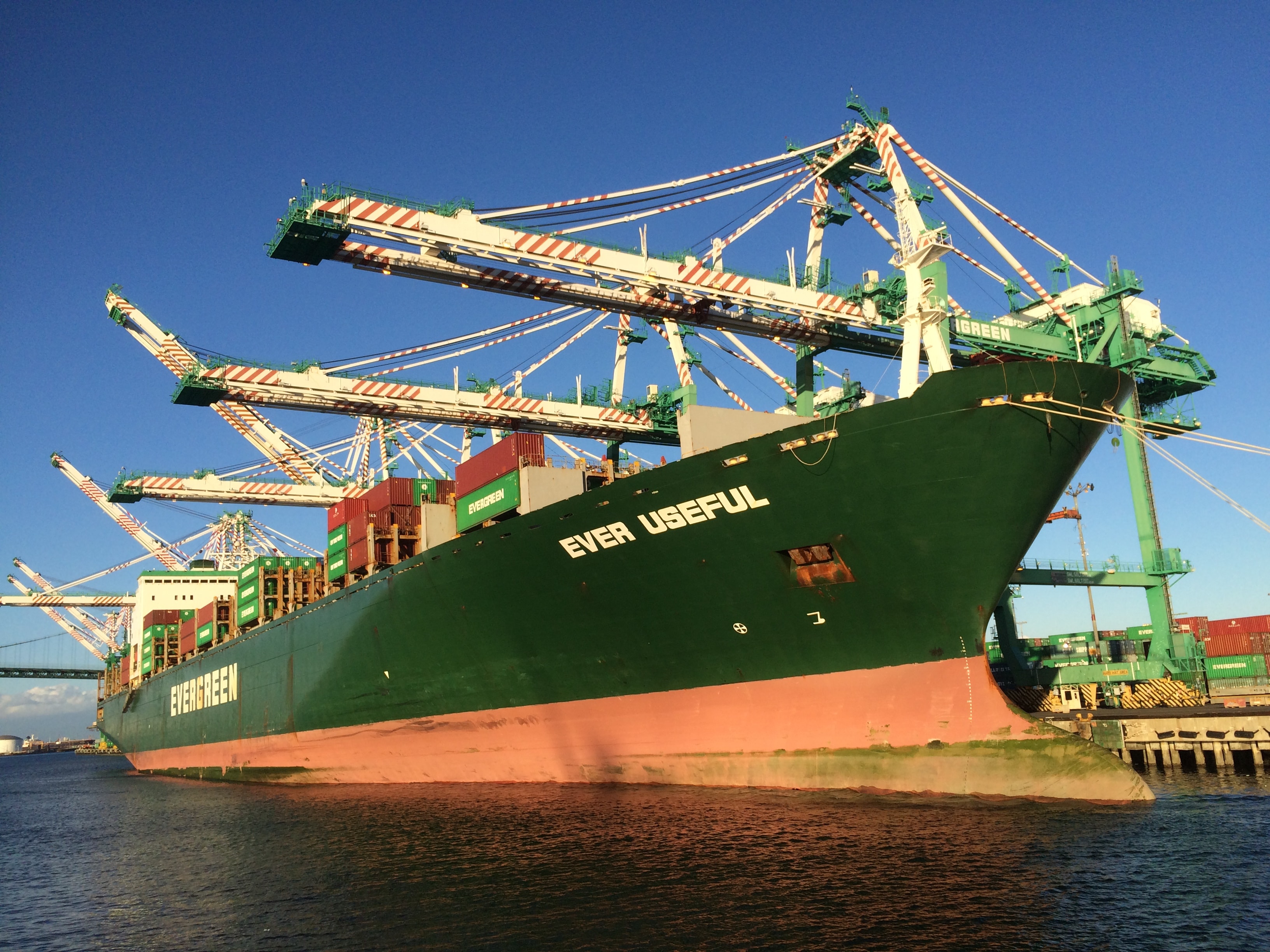
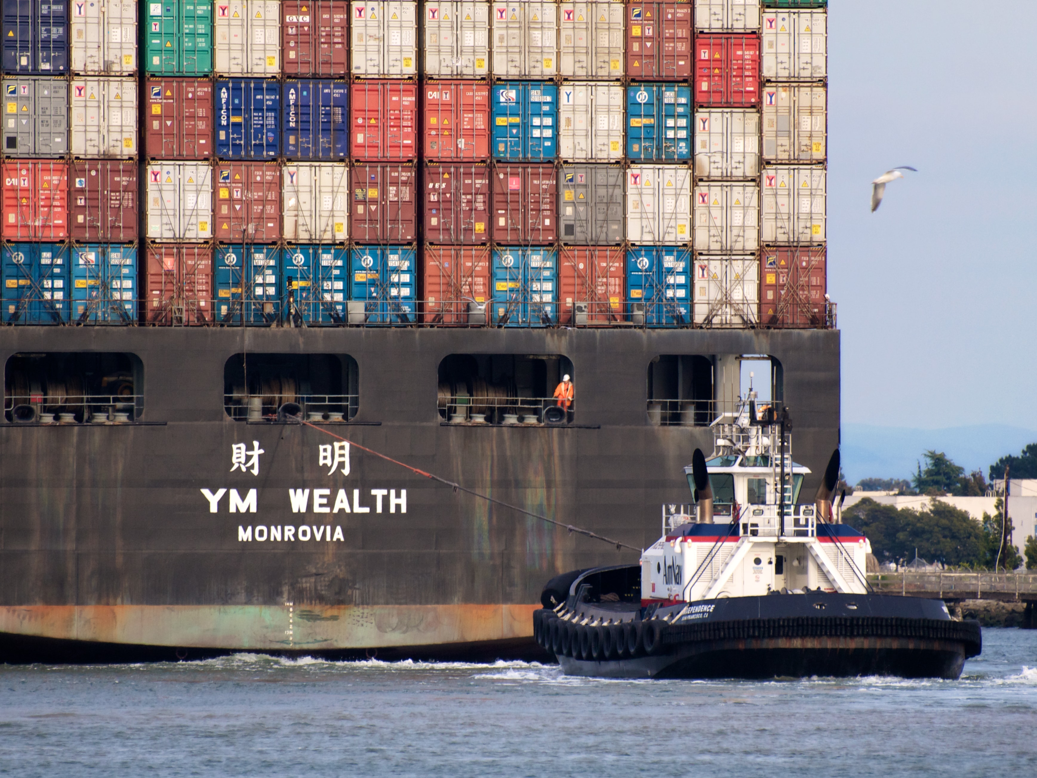
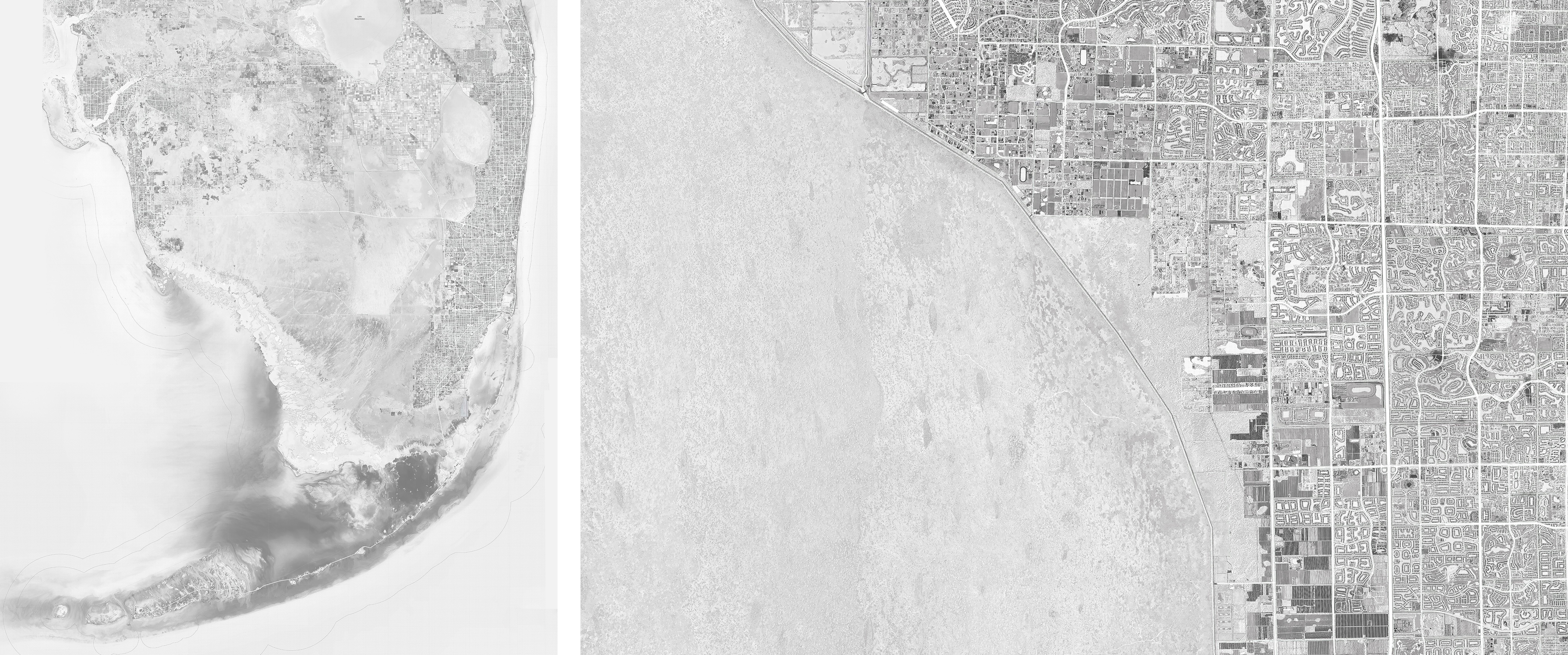
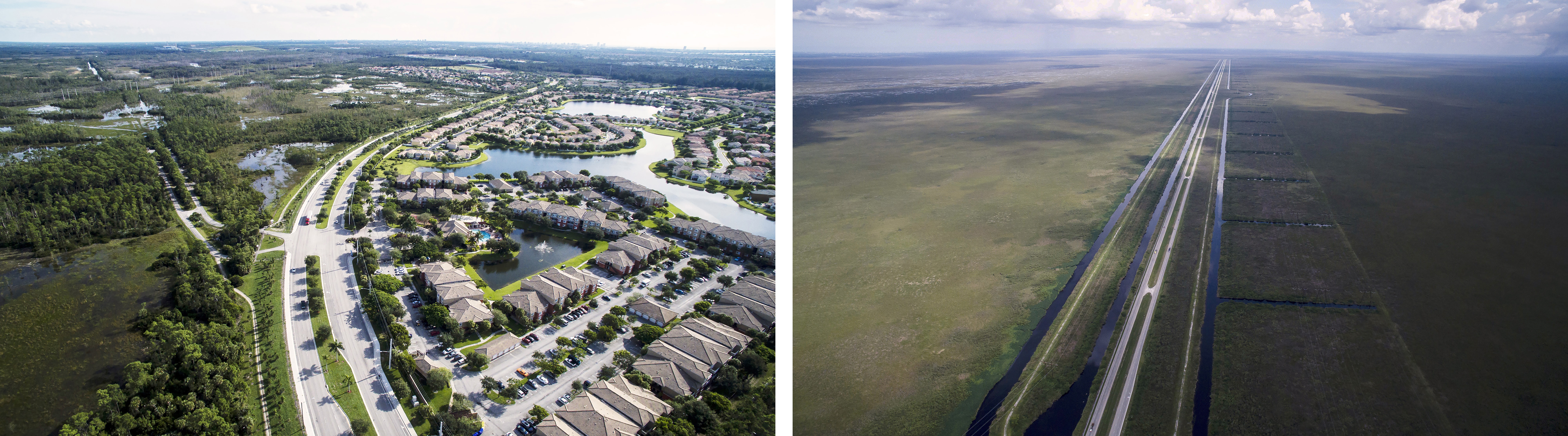
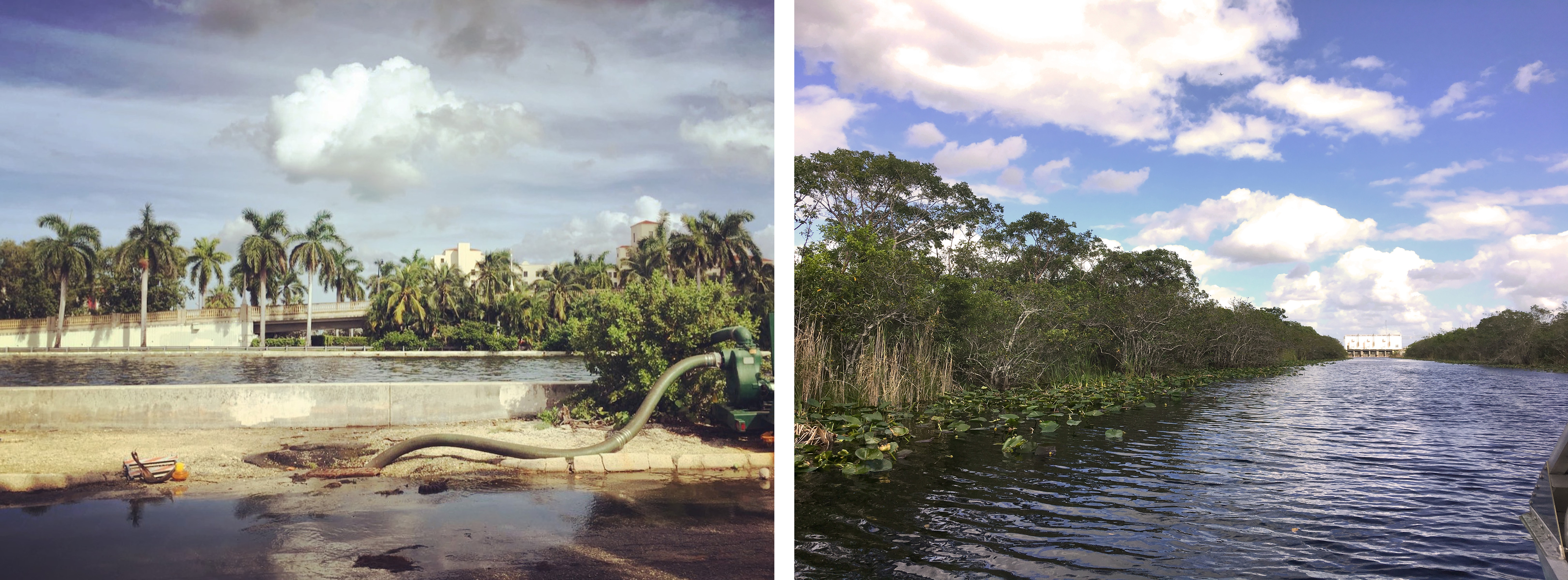
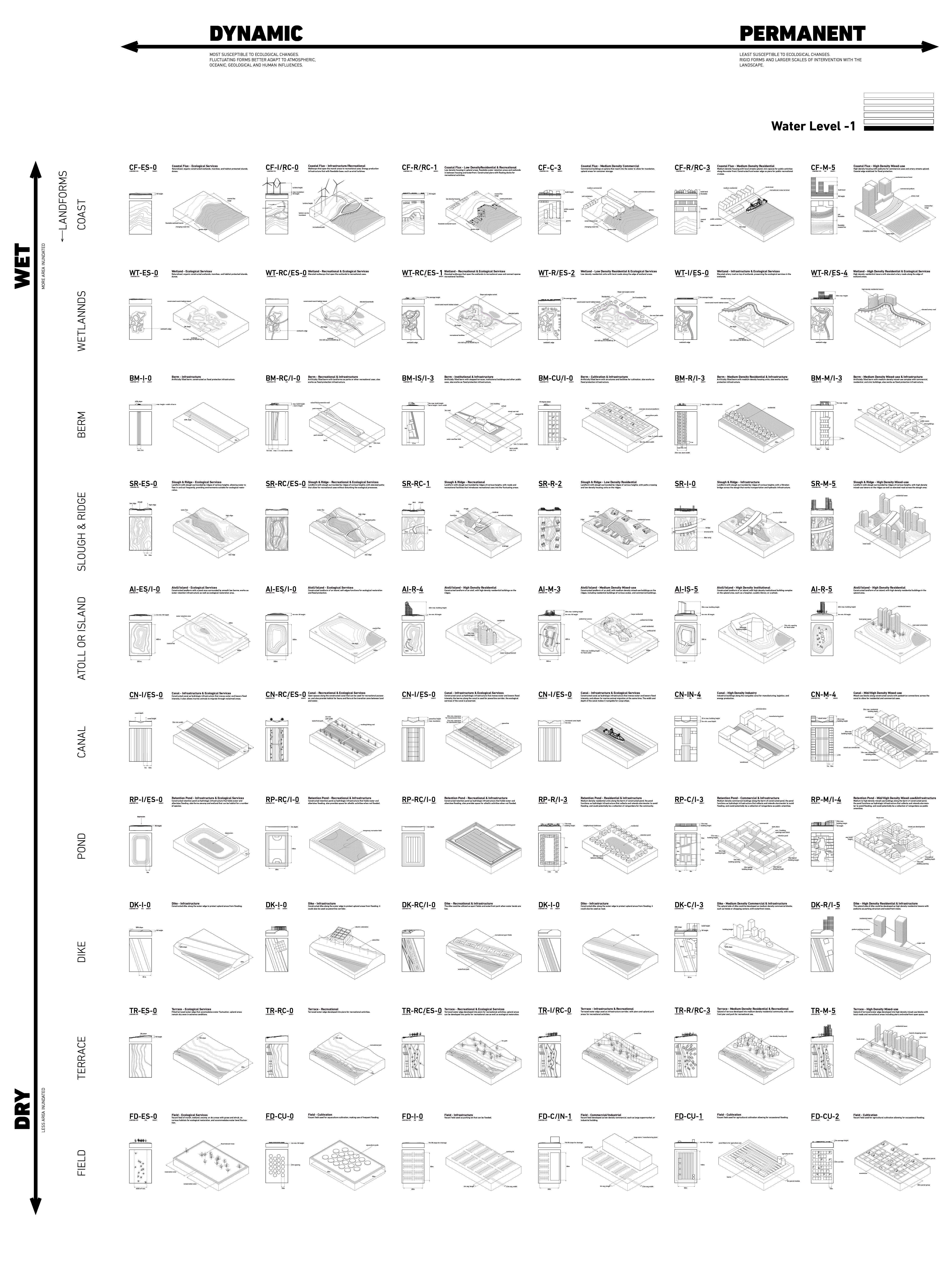
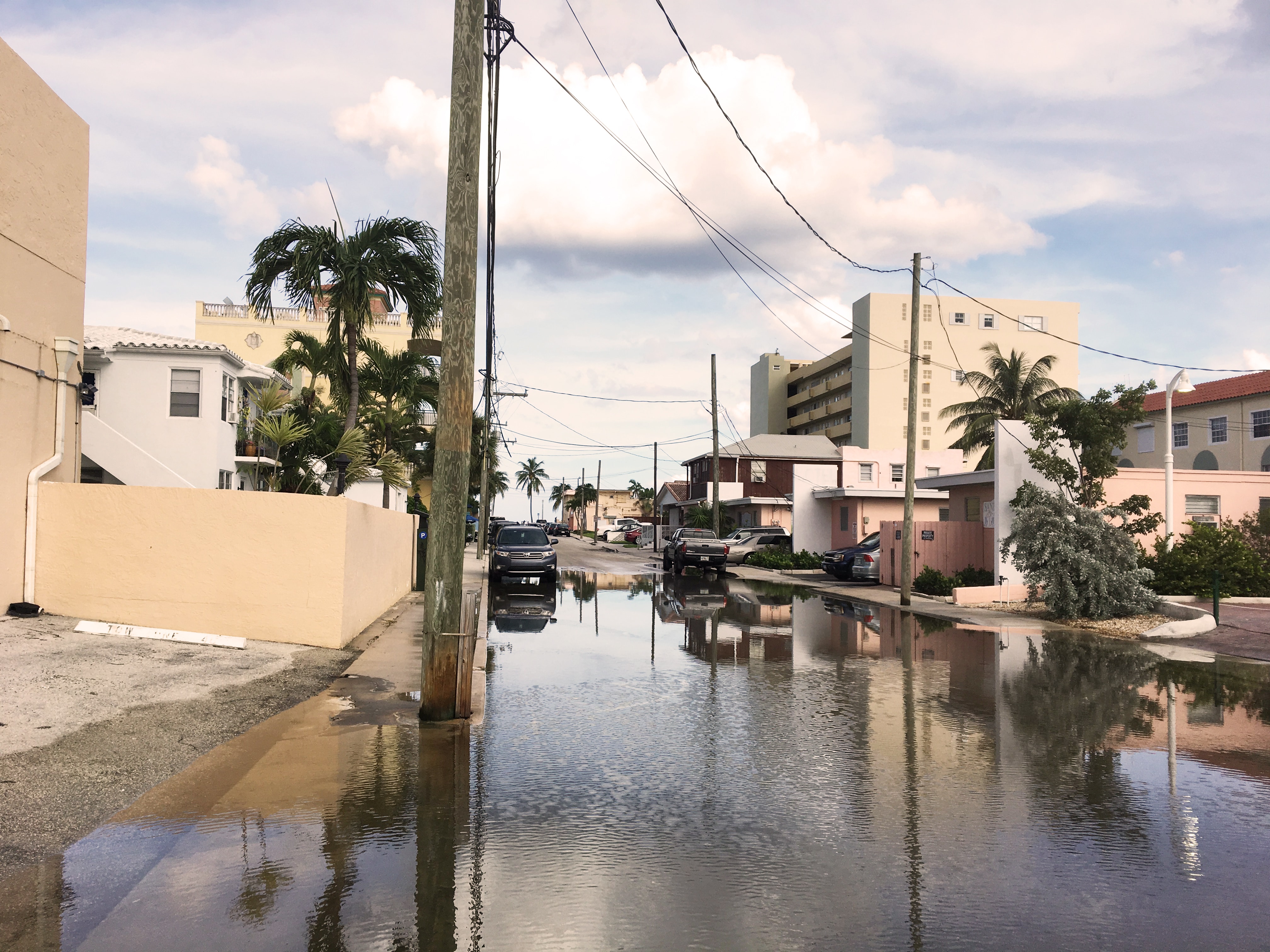
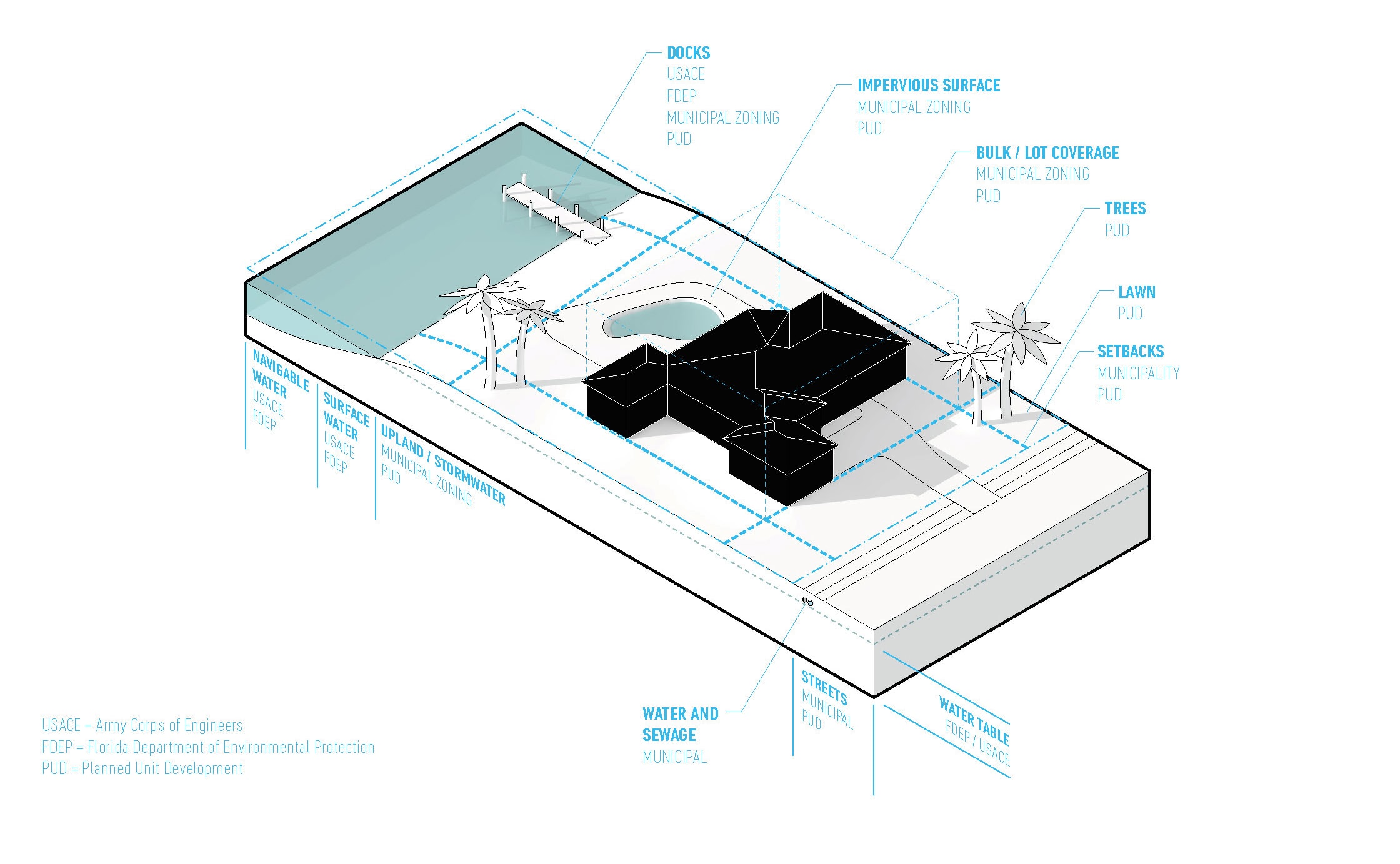
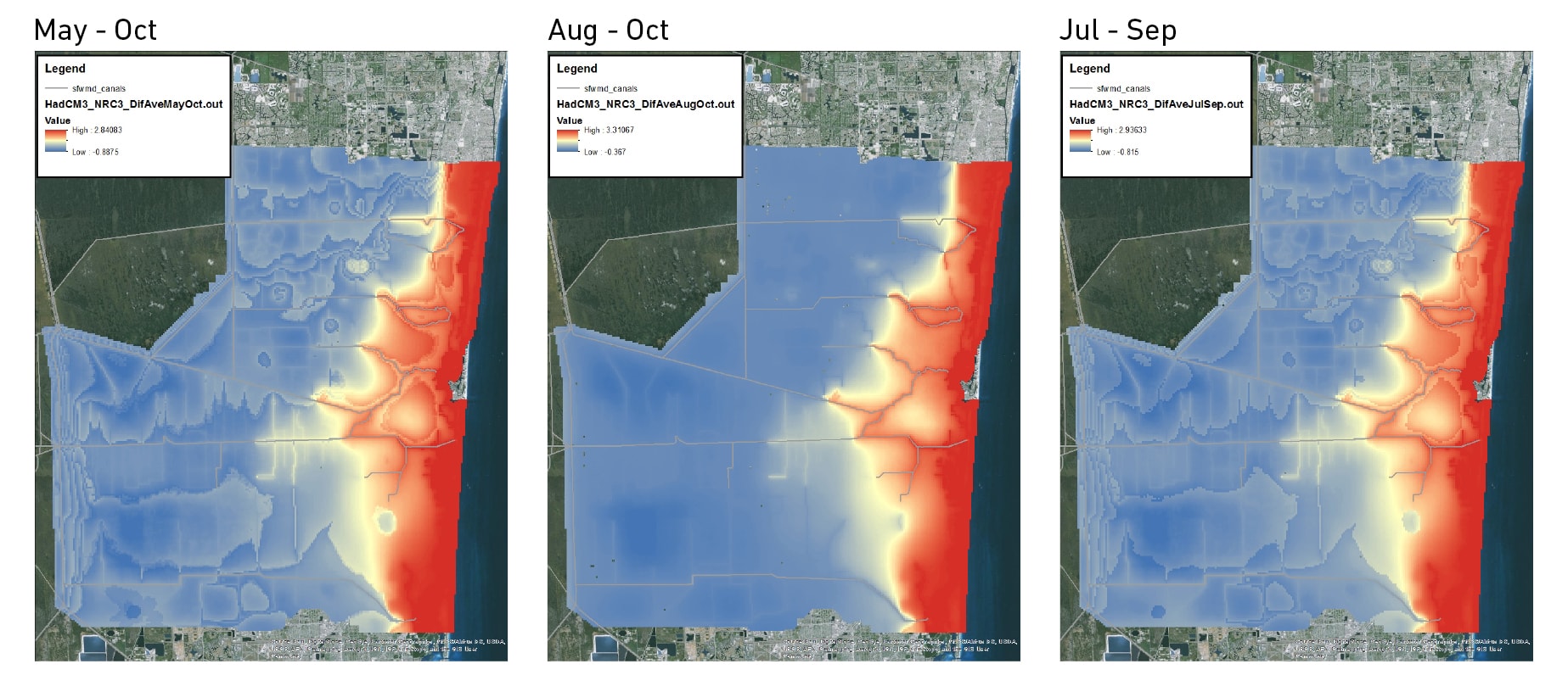
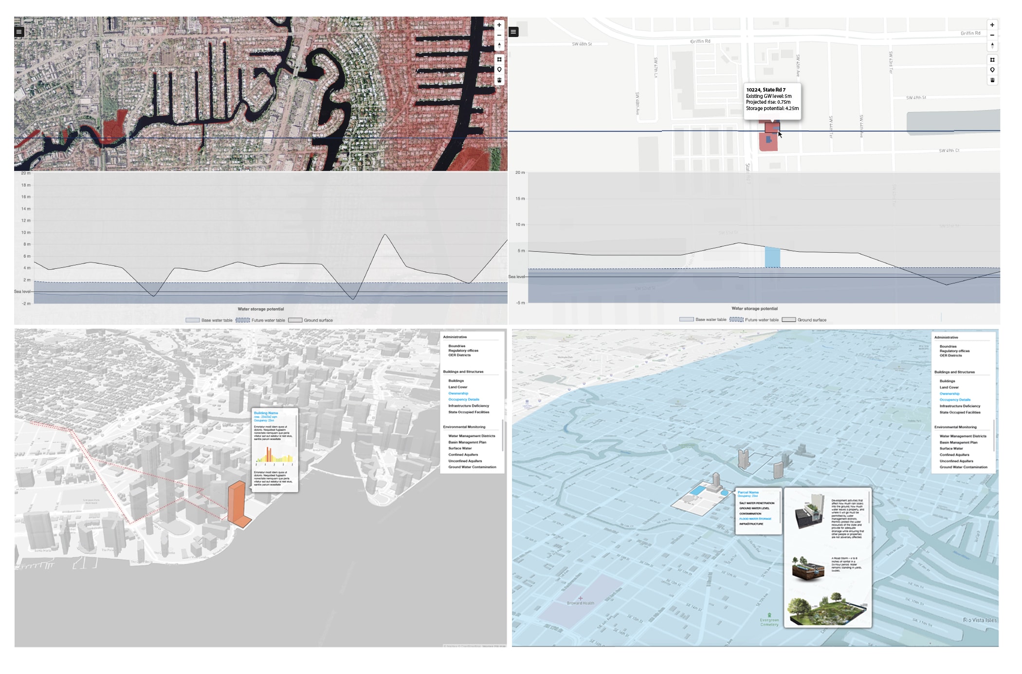
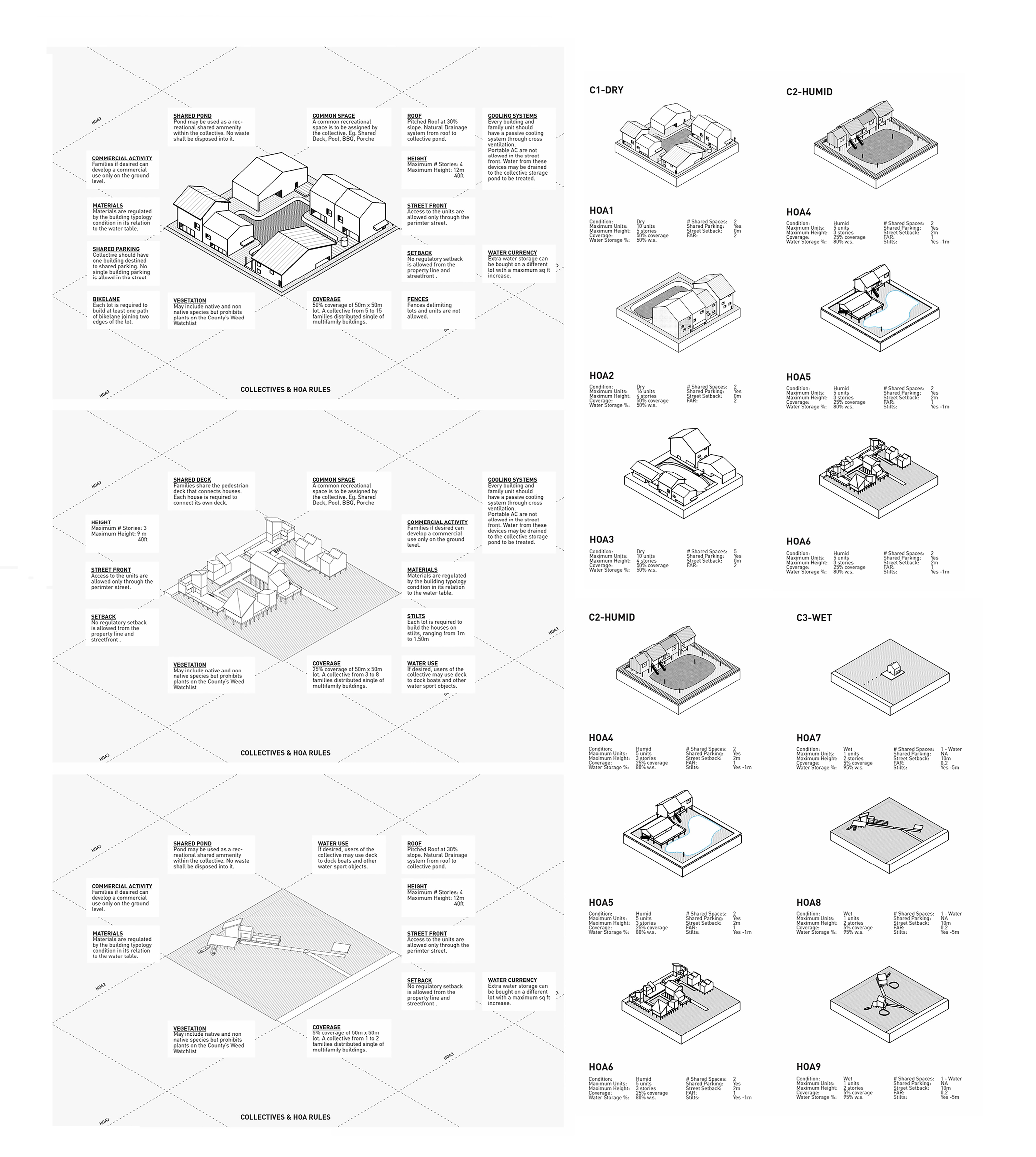
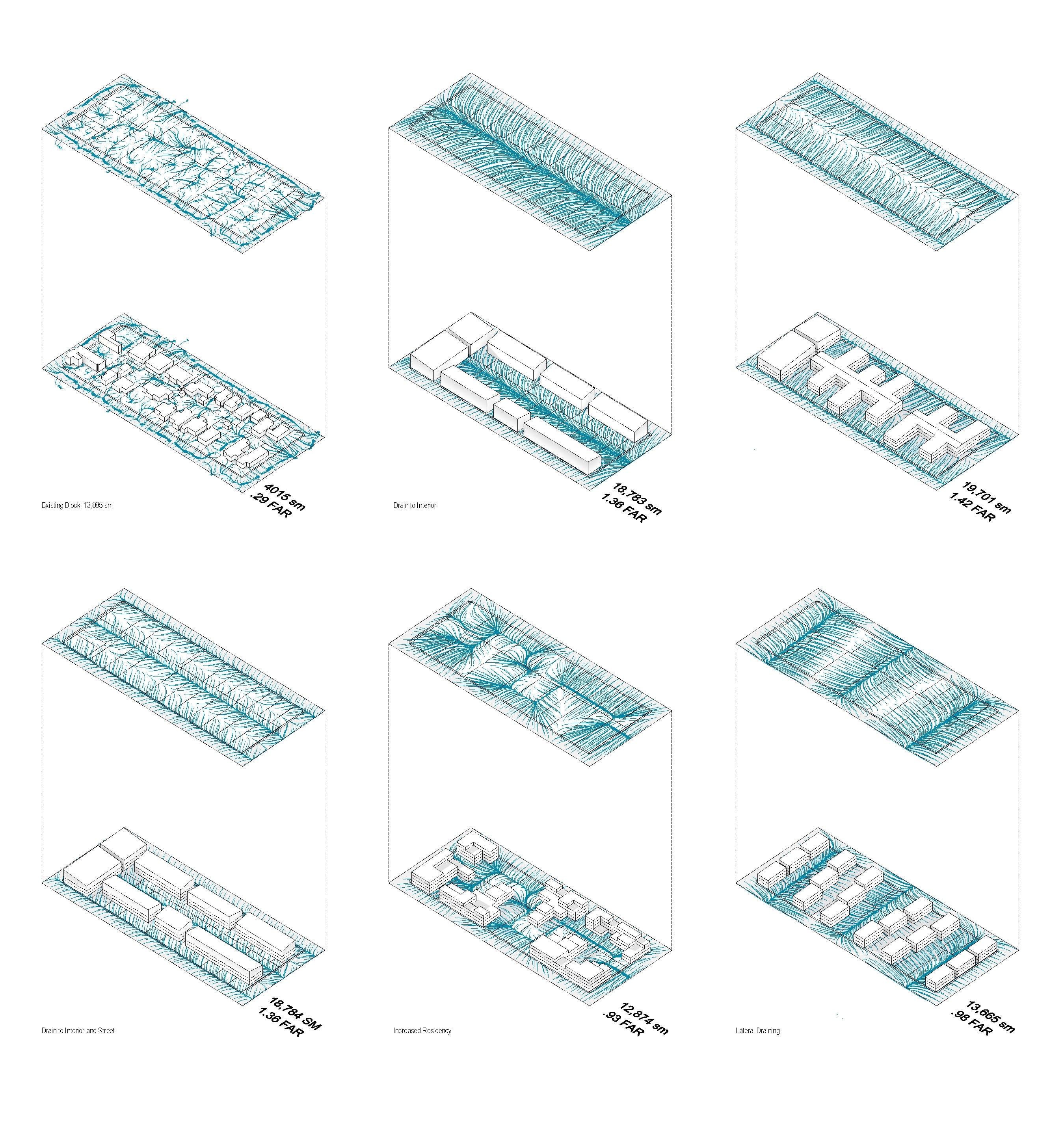
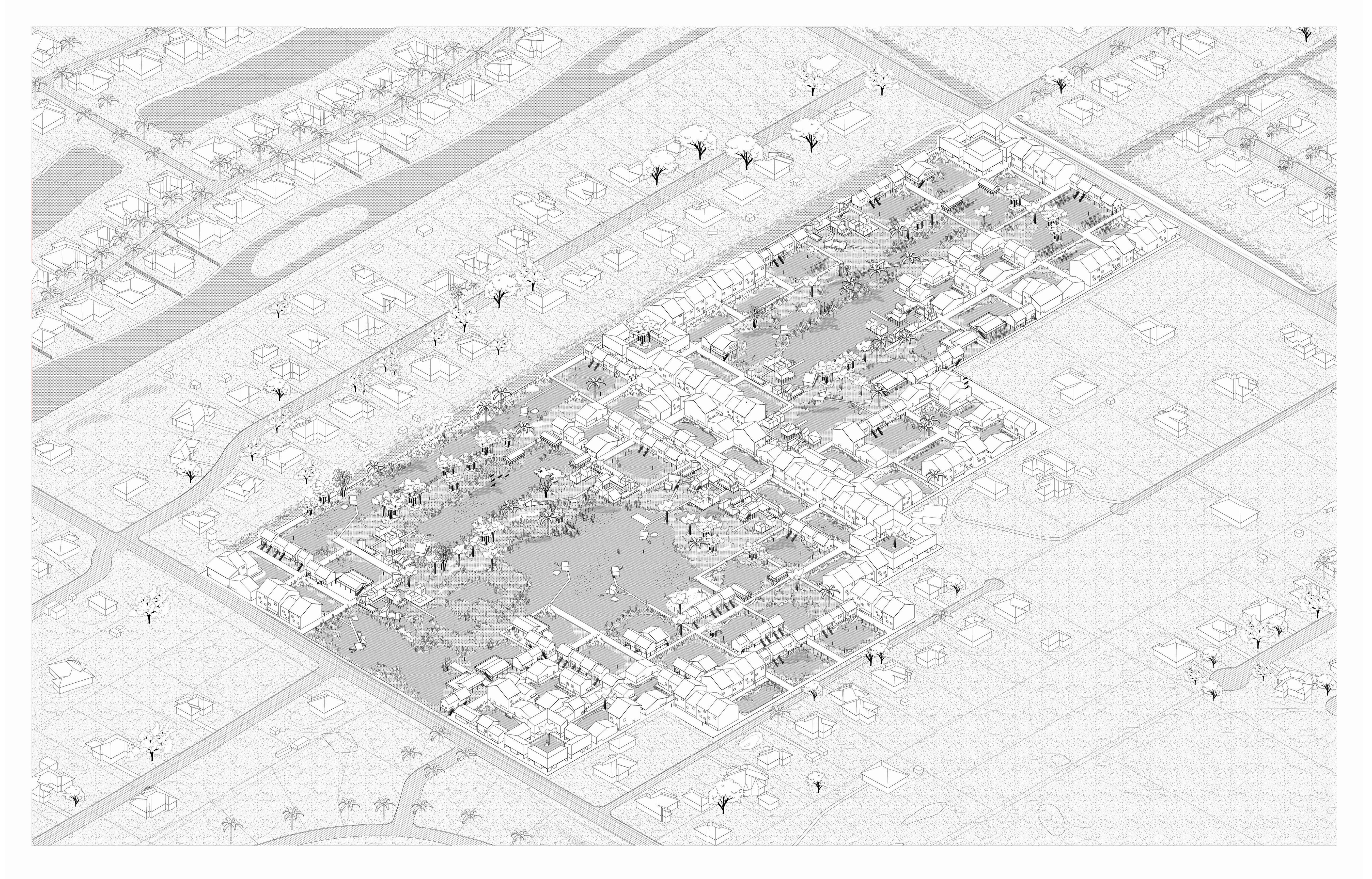
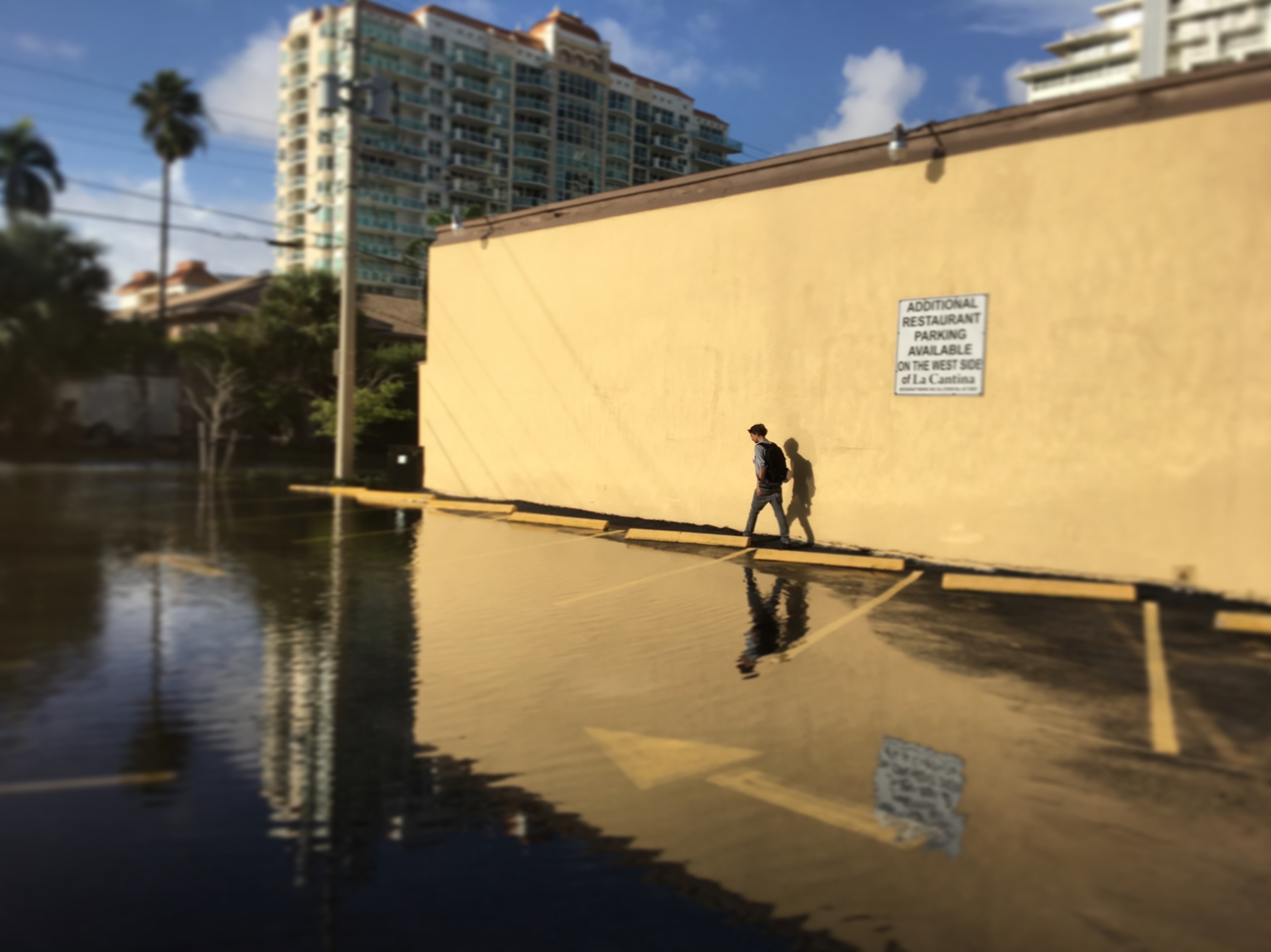
The materials that constitute our built environment similarly move through space, and can be tracked: Mike Yengling looks at how ordinary American building materials — and even entire buildings — migrate across the US-Mexico border to become reconstituted in the urban fabric of Tijuana. Alex Klatskin zooms out to look at how materials and goods travel around the world, thanks to the innovations of containerization and the port infrastructures that support it and fast-forwards to imagine the value that these vast distribution landscapes may come to have as climate change disrupts traditional patterns of coastal development. Taking on a different coastal landscape amid the pressures being unleashed by climate change, Fadi Masoud looks at Floridian coastal development, where climate disruption is already occurring and outlines a forward-looking zoning code that is able to absorb the fast-evolving four-dimensional dynamics along the migrating coast.

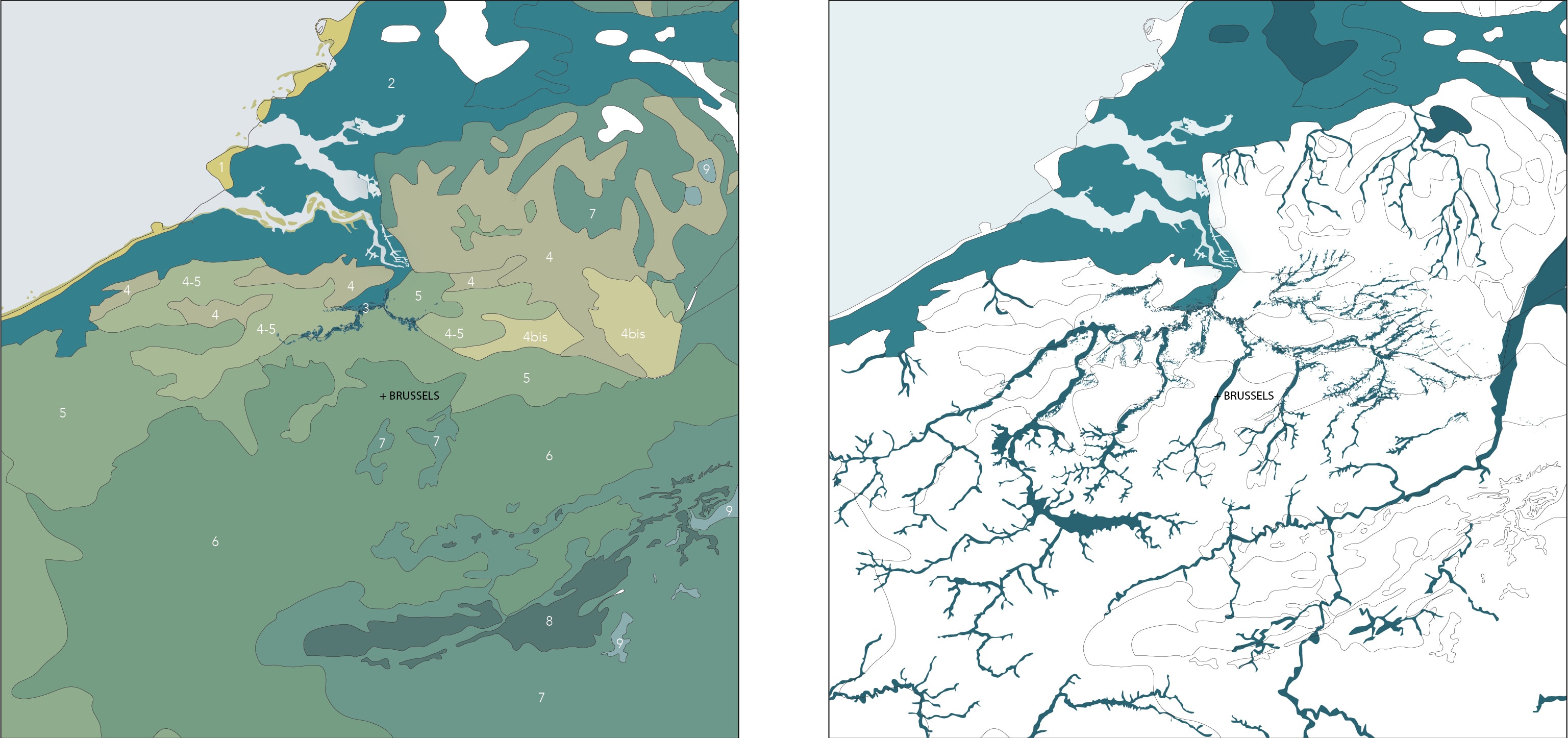
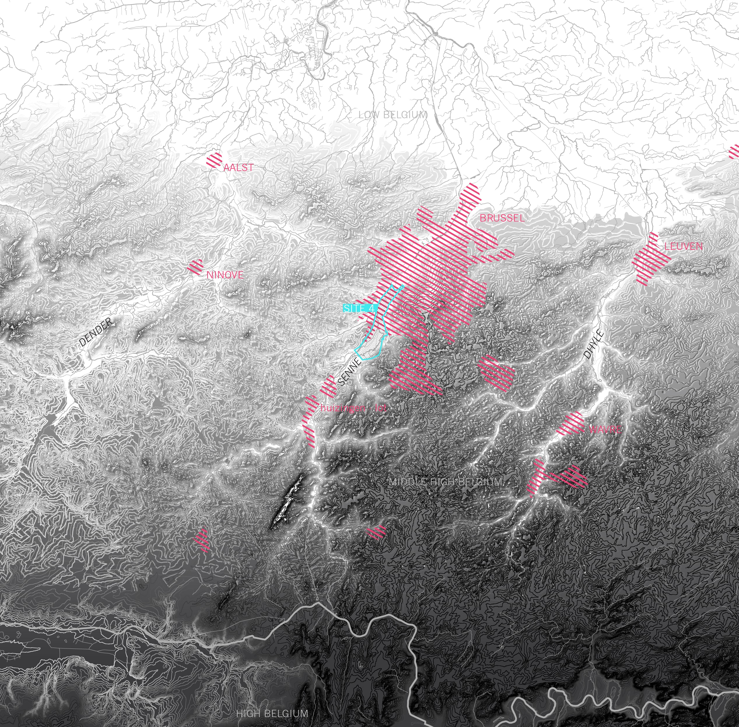
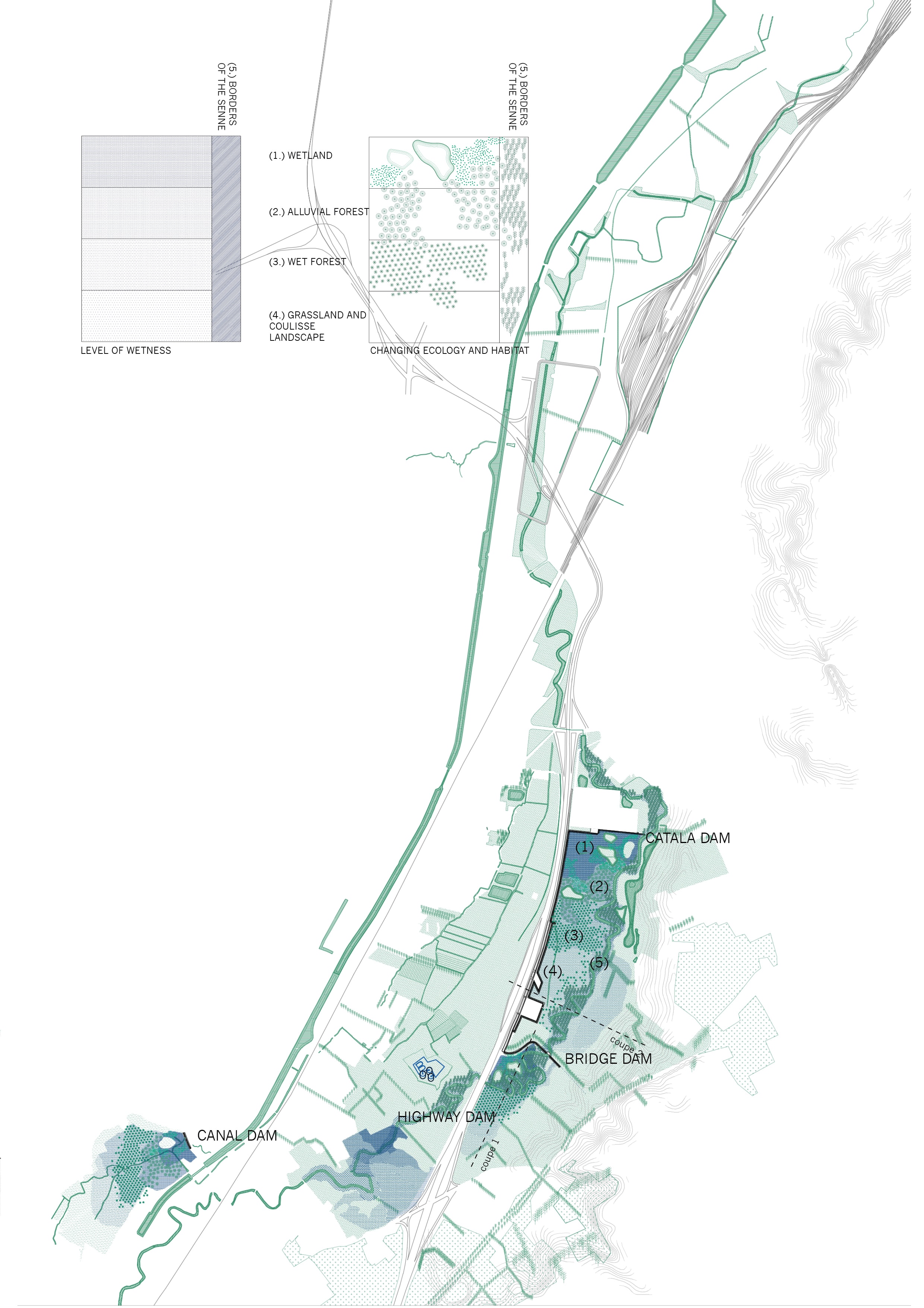
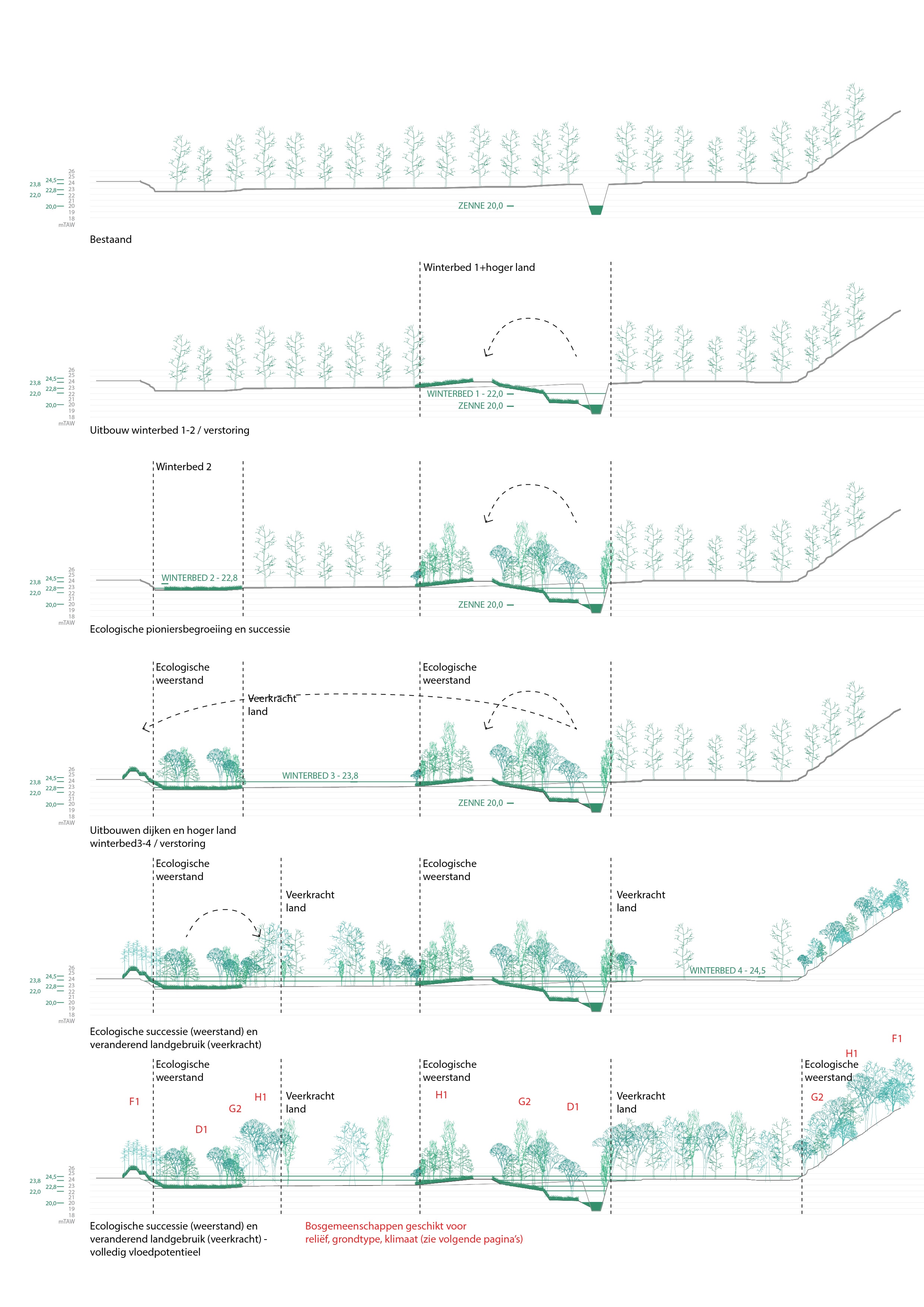
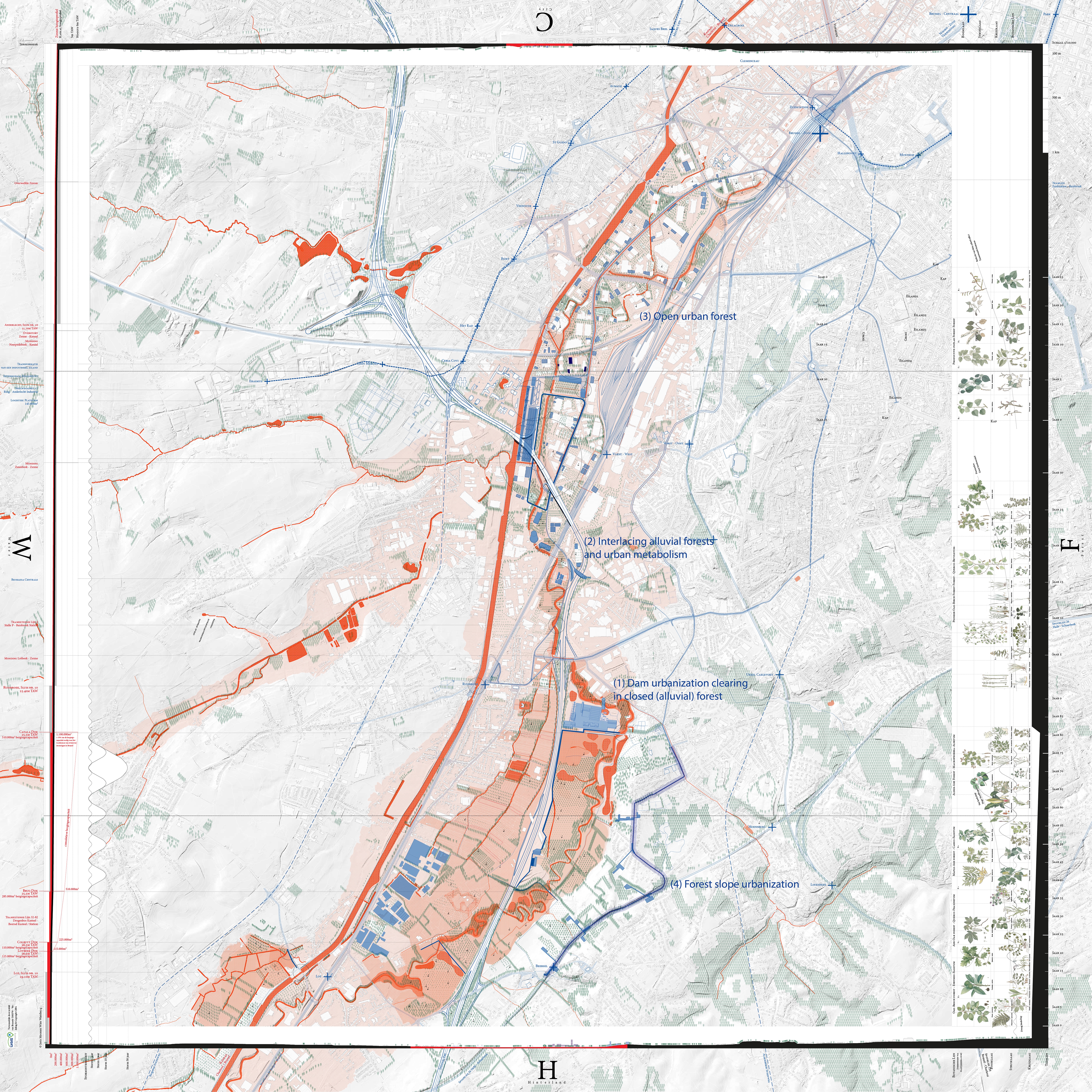
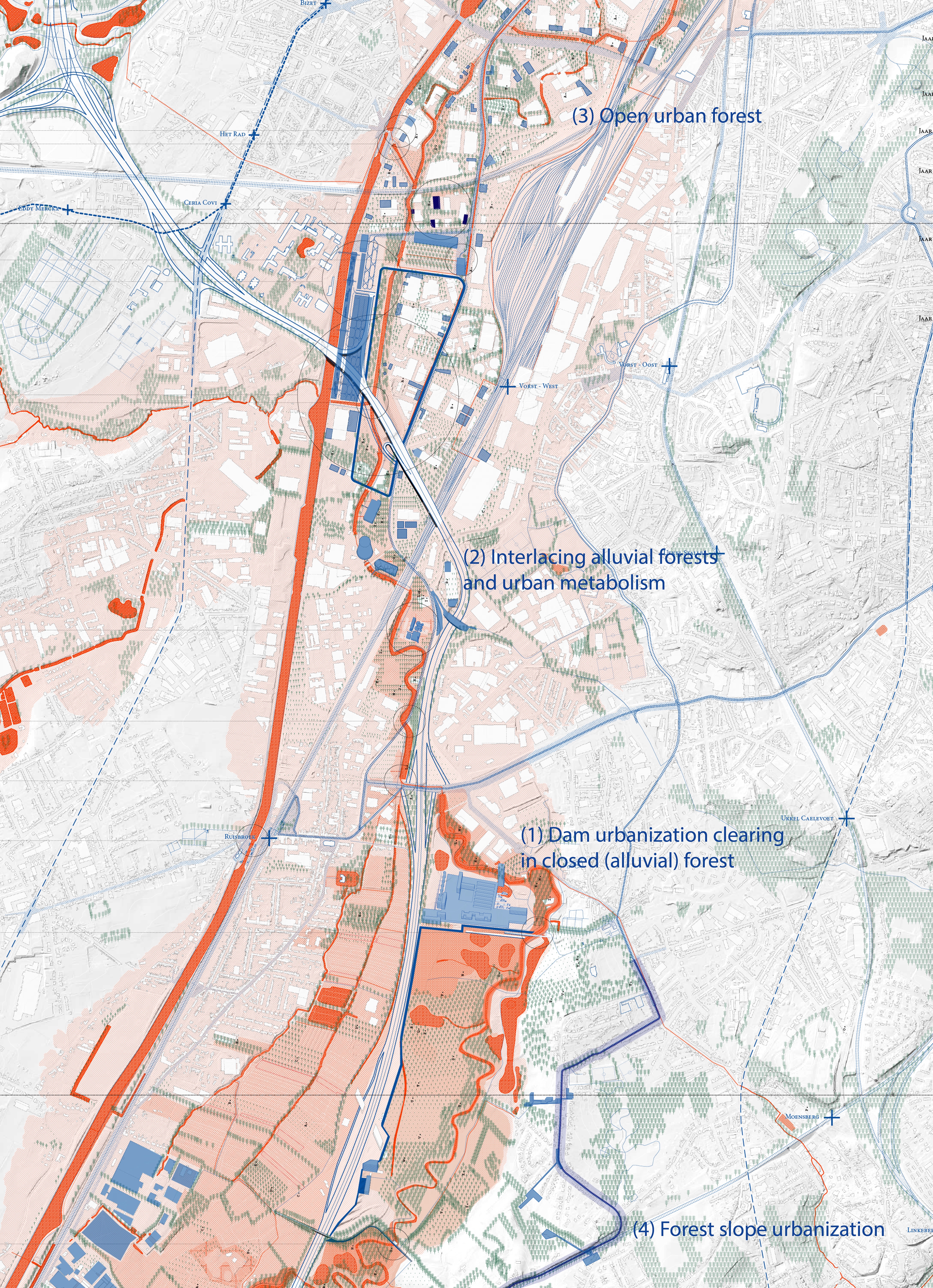
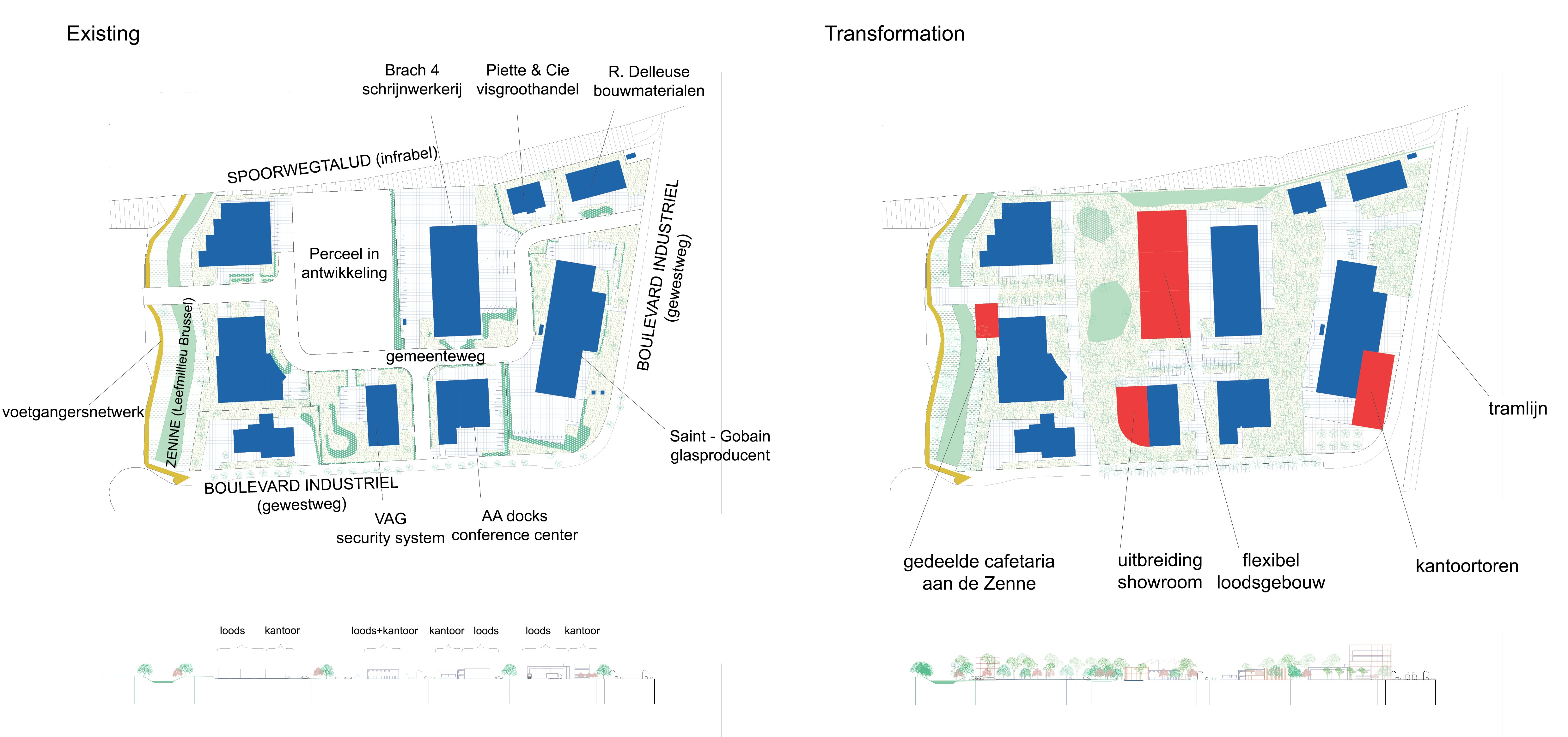
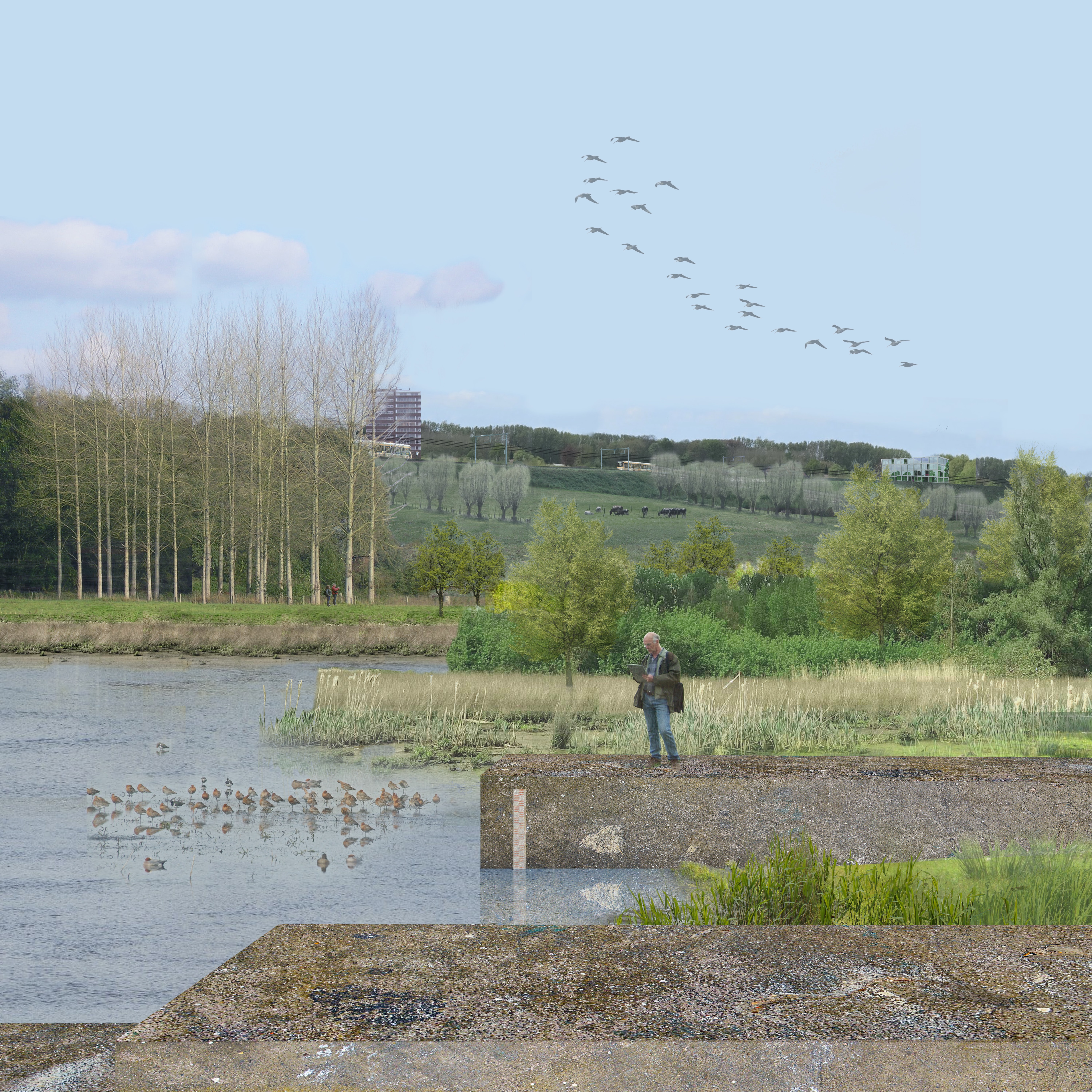
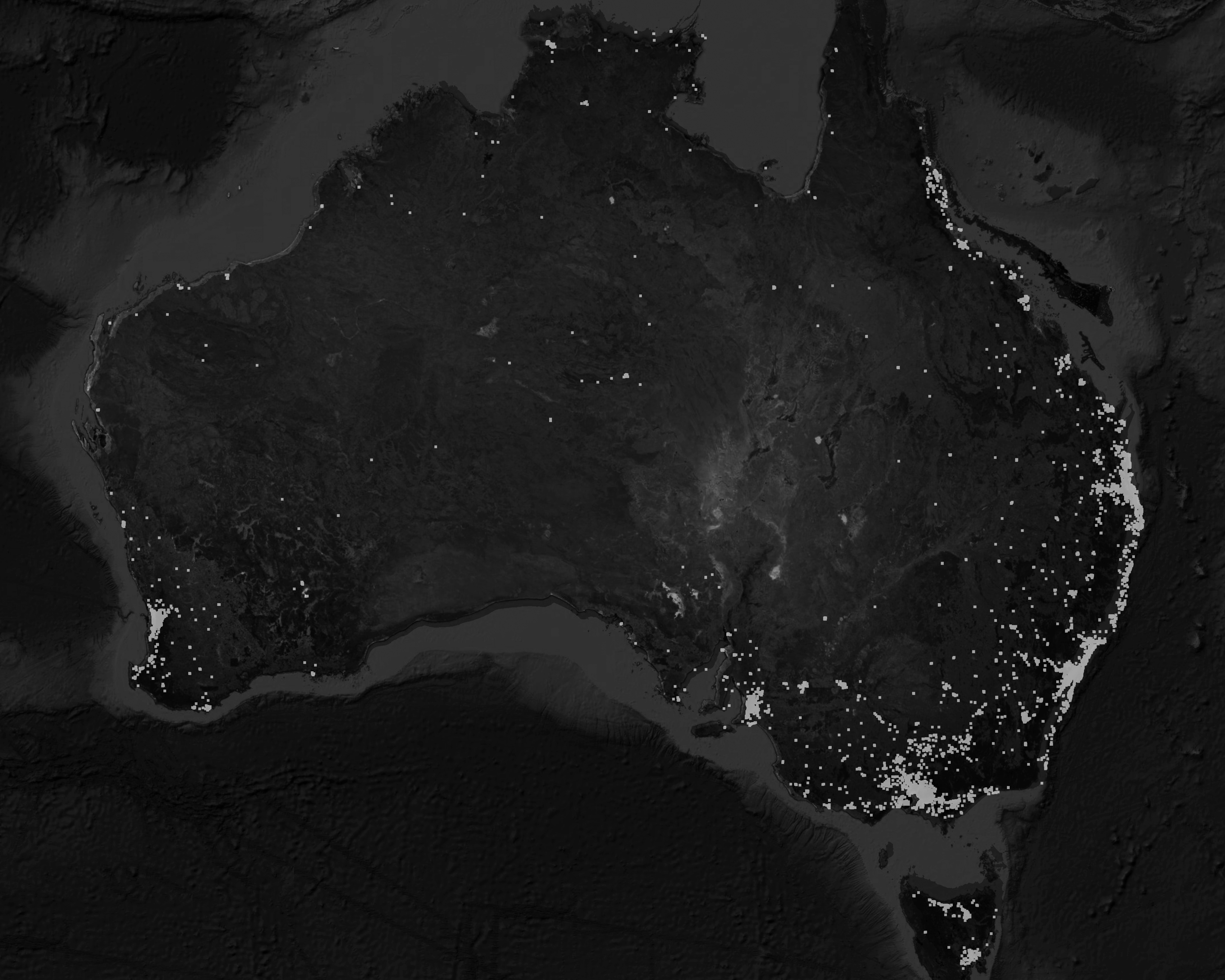
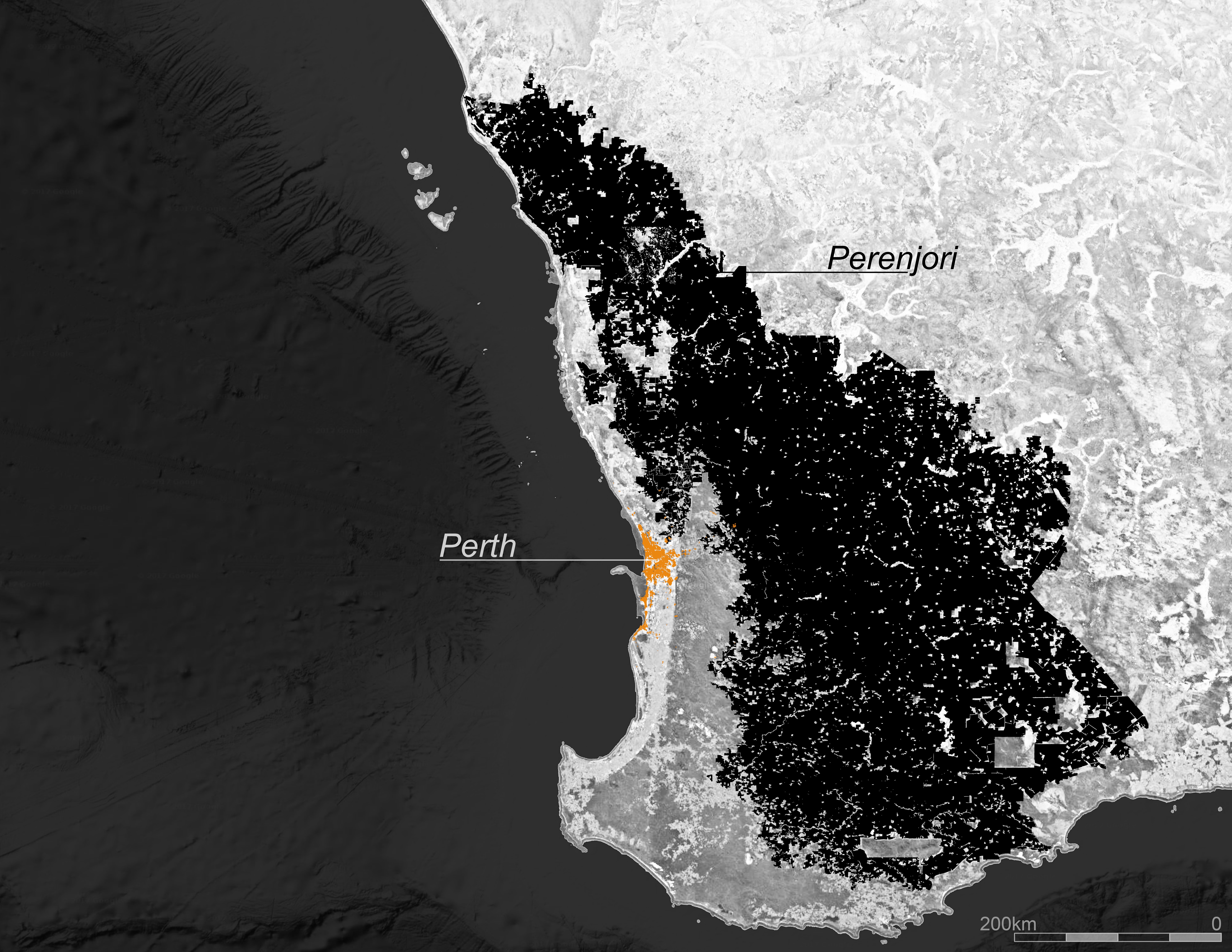
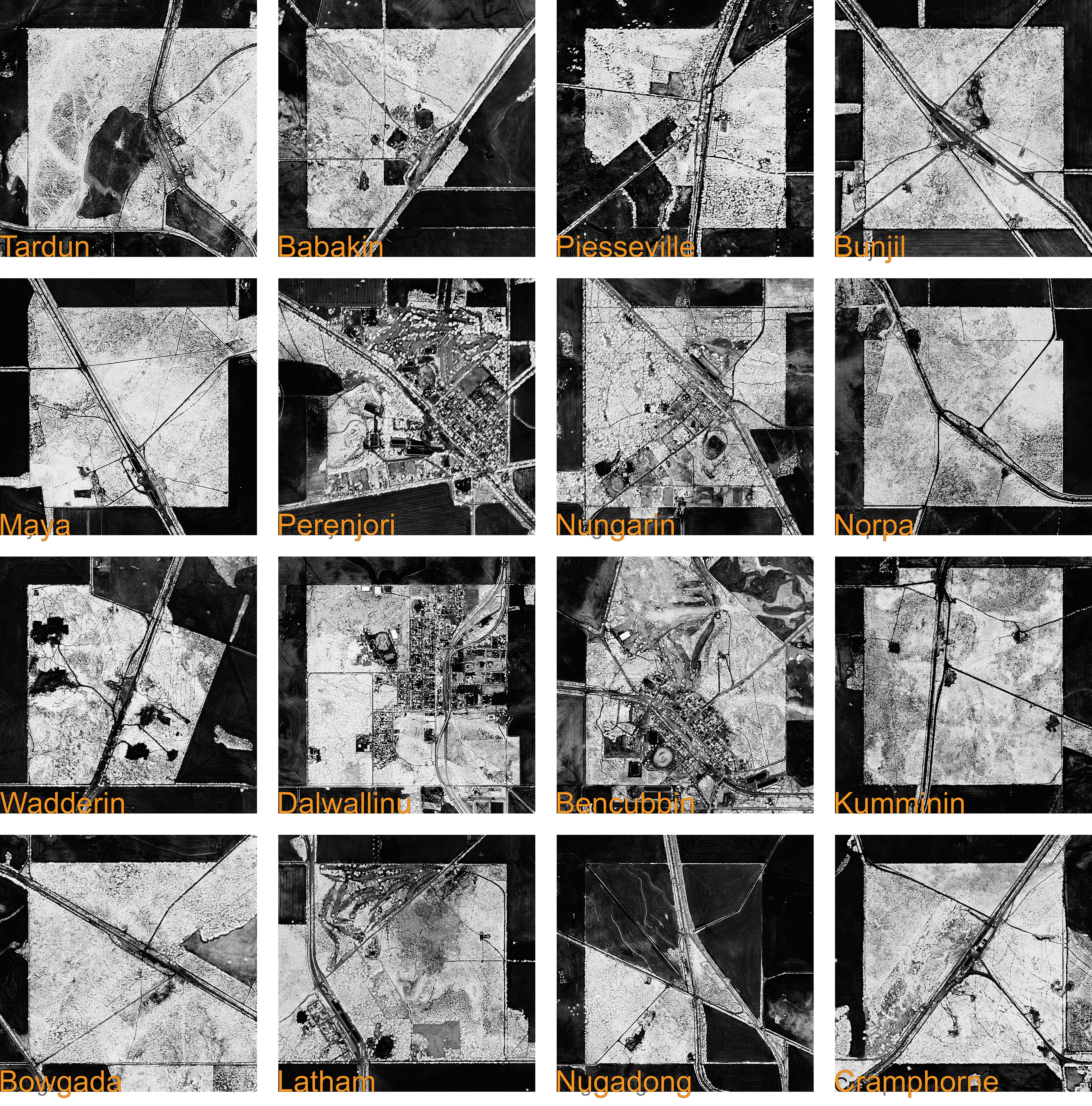
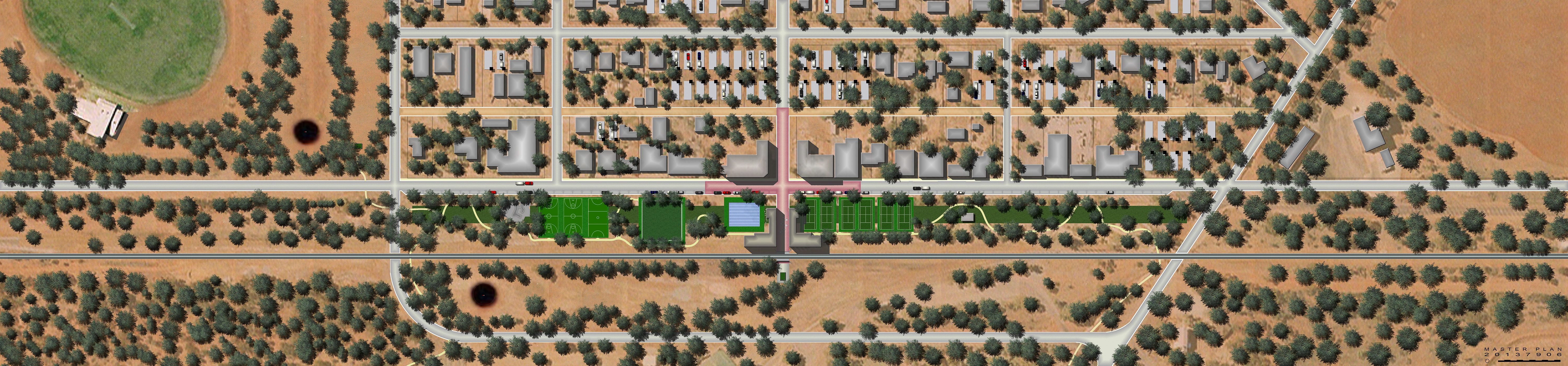
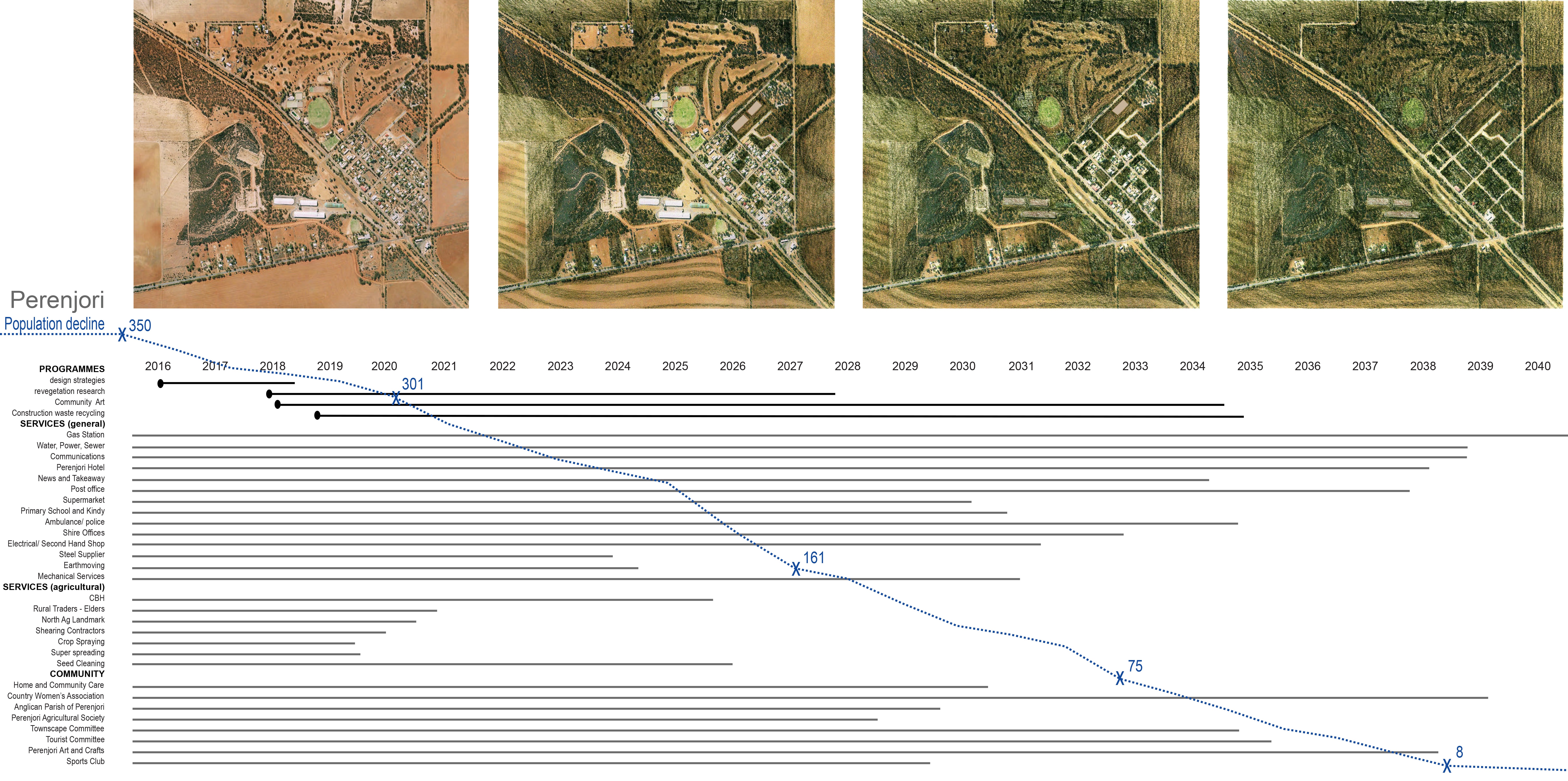
Historic migration and urbanization patterns have shaped and defined specific landscapes; several pieces investigate the how territorial reorganization can realign historic migration patterns, or initiate new ones. In the vast hardscrabble territory of the Australian interior, Karl Kullmann looks at the shrinking rural towns depopulated by rural-to-urban out-migration. His piece offers design strategies to direct a process of controlled decline, alongside a process of ecological restoration. Wim Wambecq and Bruno De Meulder seek to direct the un-building of successive layers of urban infrastructure while reshaping the hydrological and forest systems in the Brussels region with targeted design interventions, so as to unblock the migratory corridor of the Southern Senne valley for plant and animal movement.

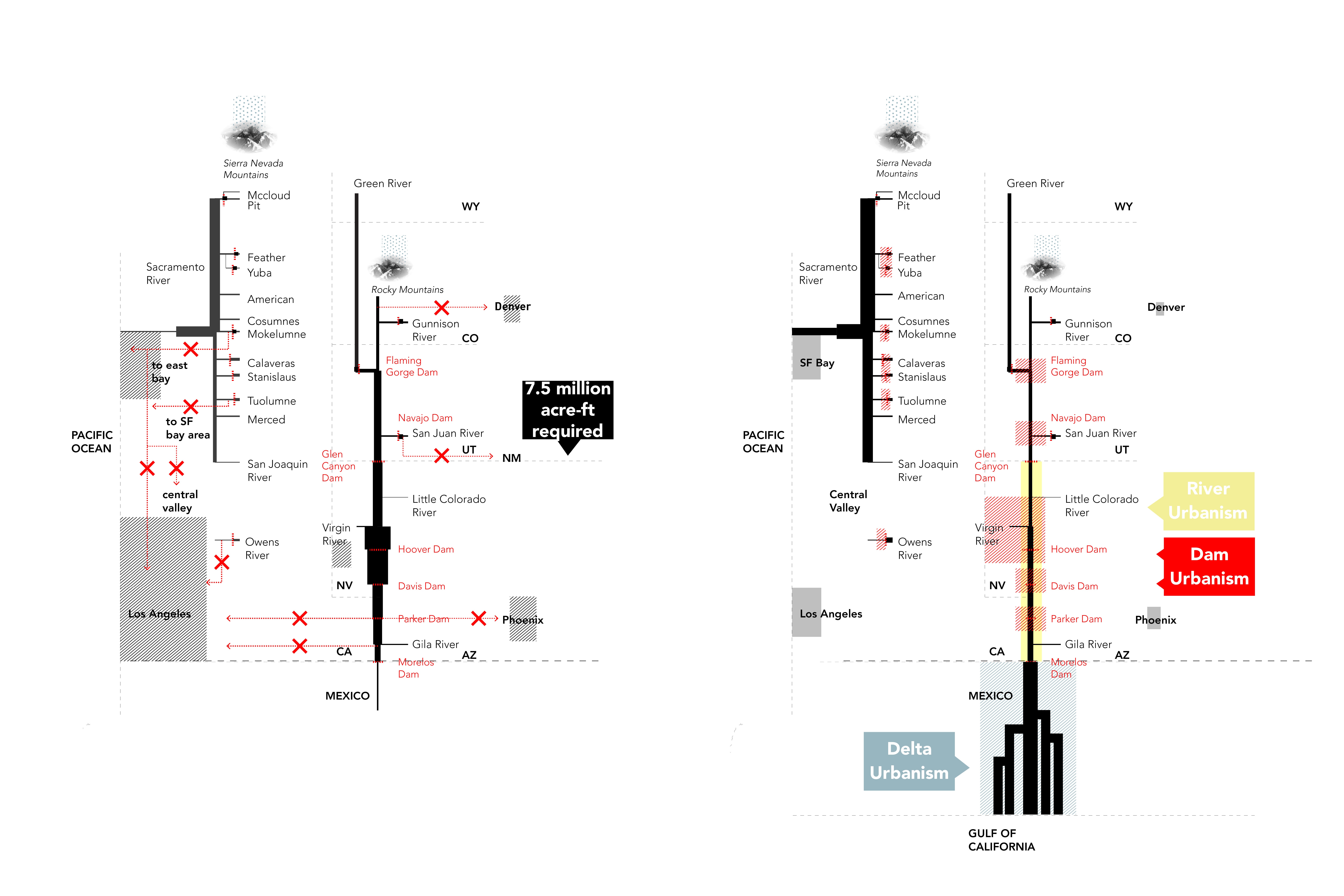
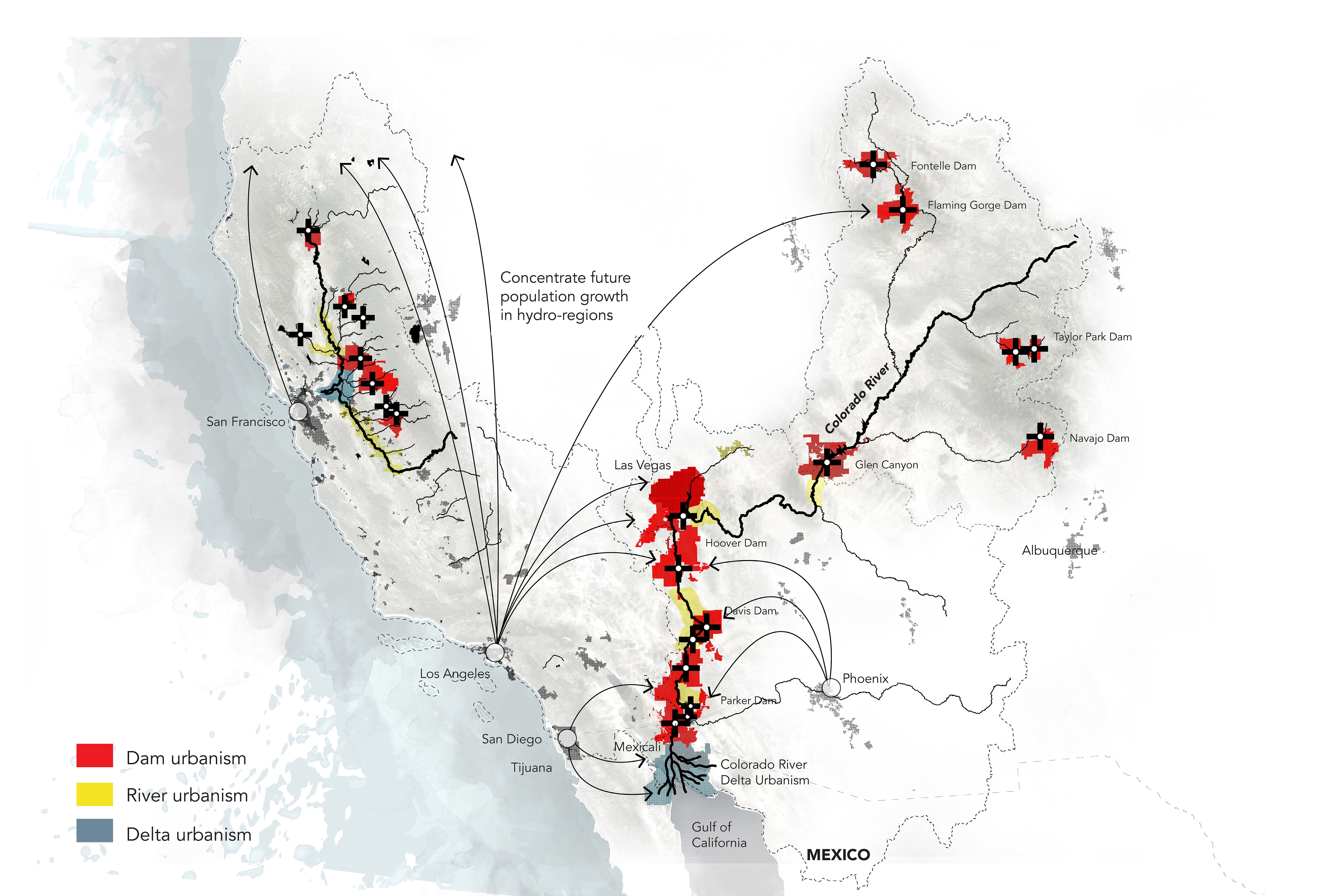
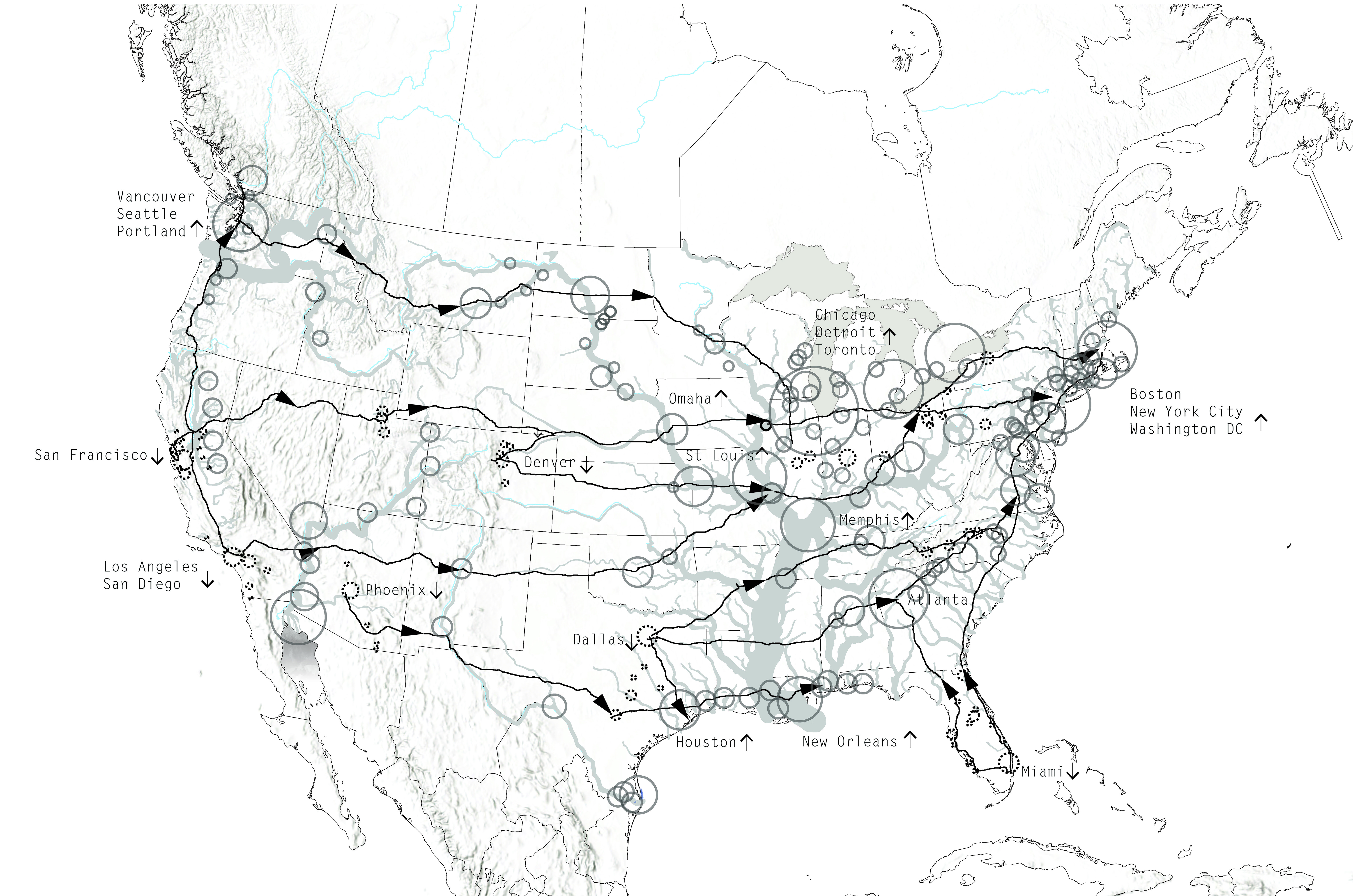
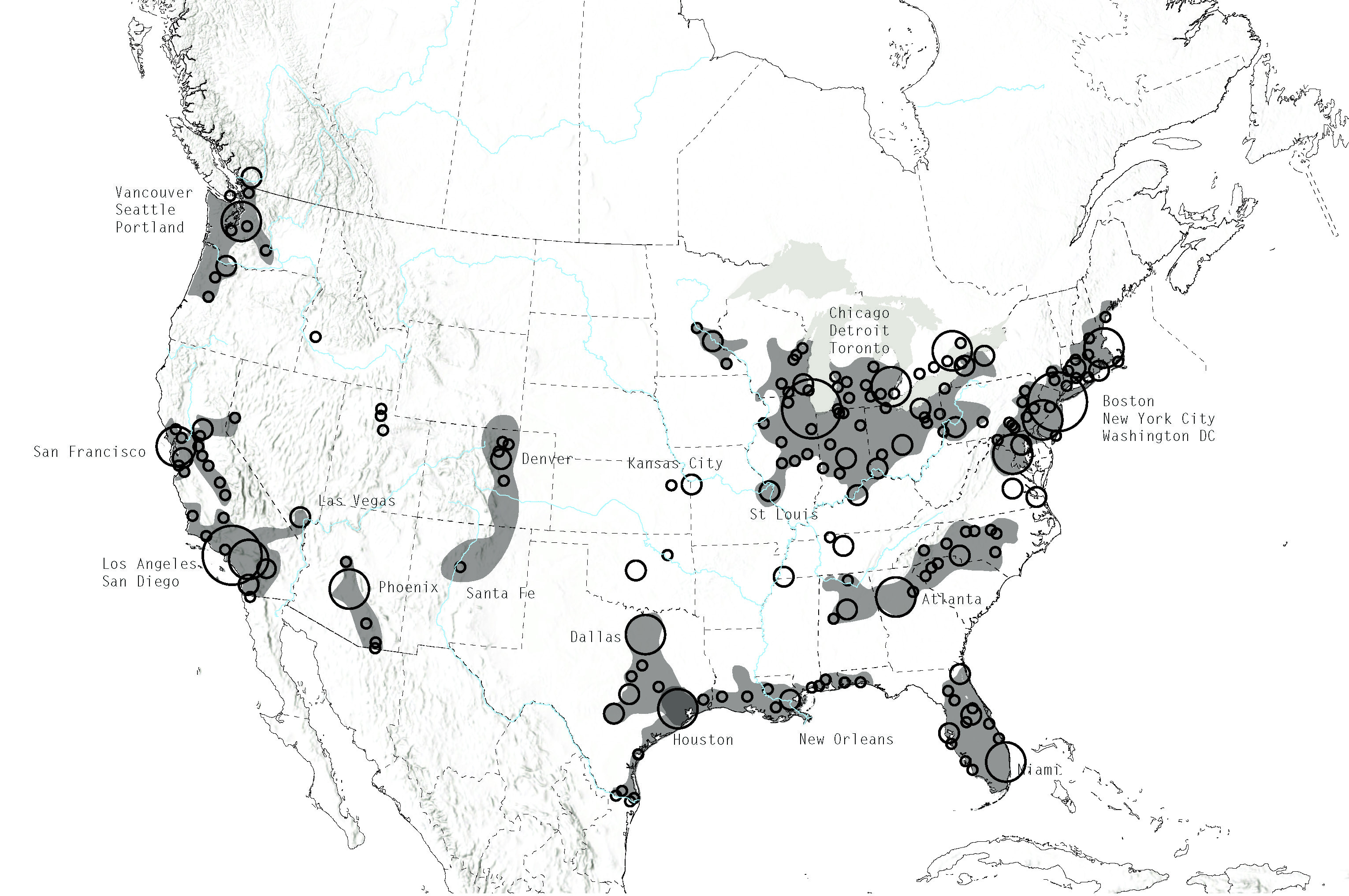
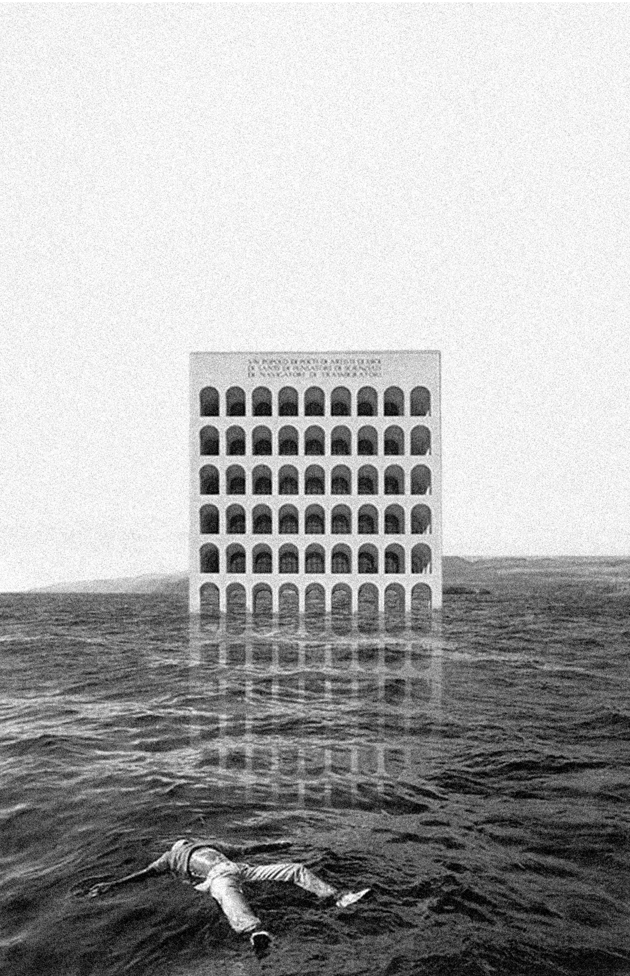
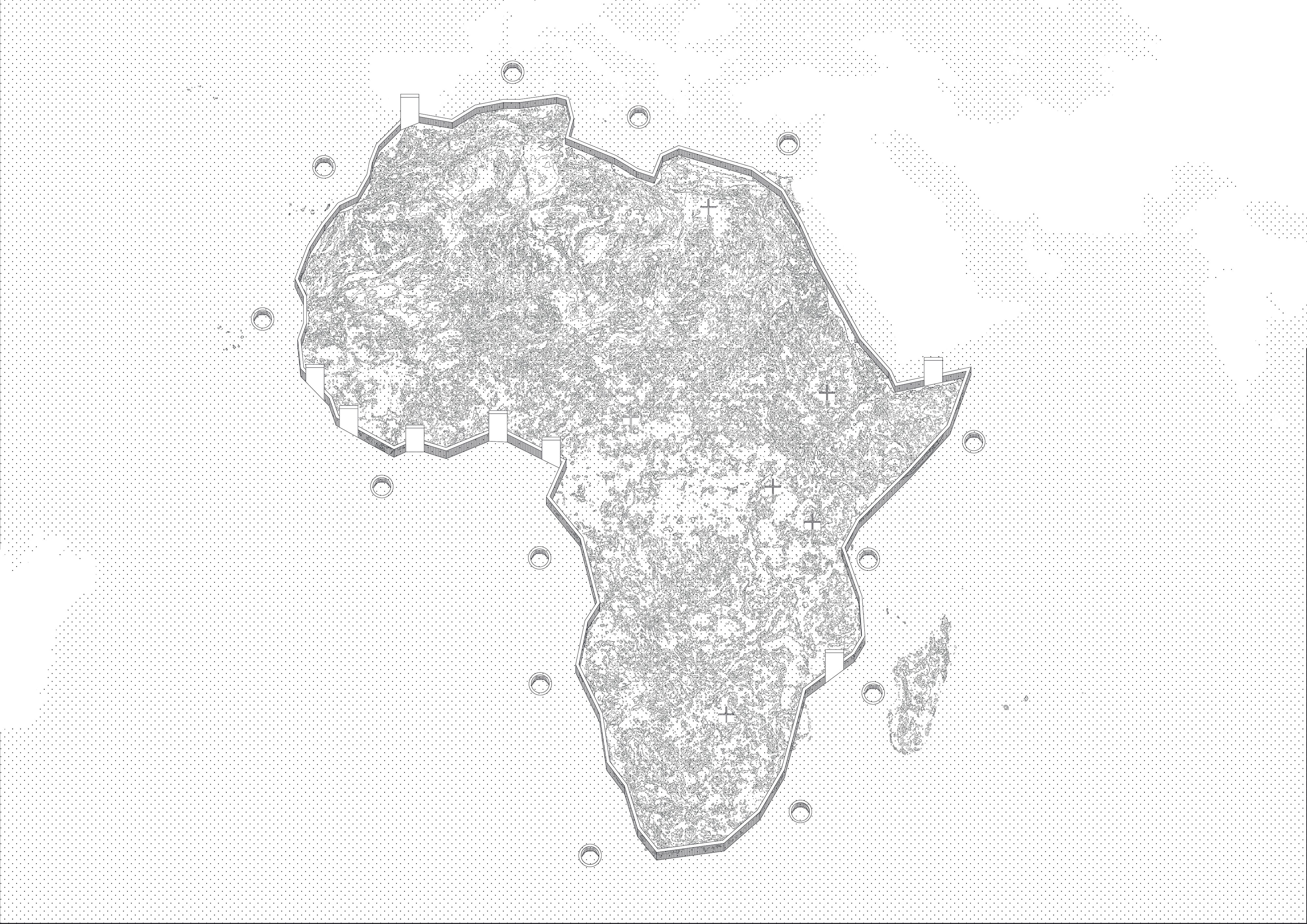
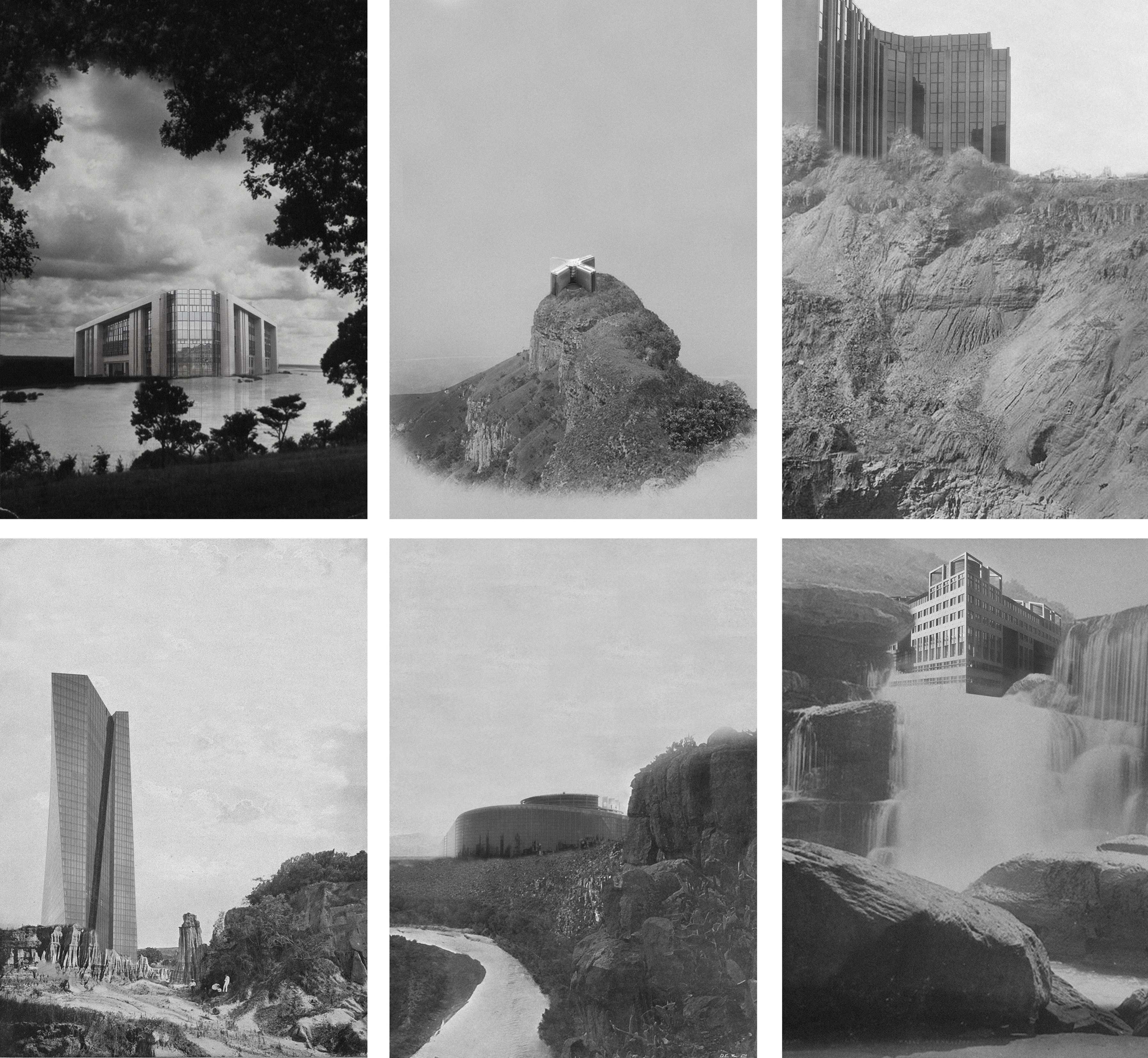
In “The Continental Compact: Eastward Migration in a (New) New World,” Ian Caine and Derek Hoeferlin offer us a manifesto for a future of increasing droughts and water scarcity. It proposes a radical realignment of urbanization and infrastructural investment under a rubric of Hydrologic Urbanism, where we stop bringing water to people and instead bring the people to the water. Extending the subversive polemical vision even further, the Belgian collective Traumnovelle offers a story of the lucky climate migrants able to relocate in high style to a vast new continent, the colonial impulse critically re-examined in light of migration’s pervasive inequalities.

The balance of pieces turn their attention to the material and political challenges and anxieties that refugees, asylum-seekers, and undocumented immigrants confront amid their daily struggles. Tami Banh and Antonia Rudnay analyze the personal journey of a single specific Syrian refugee, spatializing his experiences against the backdrop of his interactions with the abstract political landscape of Europe and its borders. Maria Gabriella Trovato visits Syrian refugees in one of the many informal tent settlements in Lebanon, and reports on how such emergency landscapes suffer from a fractured sense of belonging. Through design-build interventions, she points to several strategies for designing flexible spaces that can begin to better create community space for refugees.

In “Travel by Night,” Audrey Burns Leites follows the path of a refugee in legal limbo as he seeks to navigate the long and complex bureaucratic journey towards citizenship, unpacking the power and nuance of the physical documents that distinguish those that officially “belong” from those at the edge of society’s shadows. Finally, Eduardo Rega offers a radical vision of an urban fabric, suspended between dystopia and “real utopia,” where clever spatial tactics at the architectural scale extend the “sanctuary” of neighborhood institutions to shelter undocumented immigrants from the enforcement actions of I.C.E.

The pieces in this collection engage with the patterns of migration in an ecological, political, social, and material mode. They grapple with what it means to describe, design and represent migration and movement. This topic is evolving and will continue to unfold with ever-more interconnections, and unforeseen feedback loops as other social and biophysical systems respond to the dynamics stirred up by this era of profound planetary change. We hope that we have offered a few ways into this fraught and contentious — but fascinating — topic, and hope that you continue this conversation.

SCENARIO 6: Migration Cover Image by Rick Bohn
Table of Contents Header Image by United Nations Photo
Feature image by Don McCullough

Stephanie Carlisle is a designer and environmental researcher whose work focuses on the relationship between the built and natural environment. She works in the research group at KieranTimberlake Architects. She is a co-editor of this issue and teaches Urban Ecology in the Department of Landscape Architecture and Regional Planning at the University of Pennsylvania School of Design. 


Nicholas Pevzner’s research focuses on the public and civic potential of infrastructure, and explores the role that infrastructural landscape moves can play in structuring and sustaining healthy cities. He teaches in the Department of Landscape Architecture and Regional Planning at the University of Pennsylvania School of Design. He is a co-editor of this issue. 


Notes

[1] Michael Begon, Colin R. Harper Townsend, L. John, R. Townsend Colin, and L. Harper John. Ecology: from individuals to ecosystems. (New York: Wiley Press, 2006).
[2] Held, David. “Climate Change, Migration and the Cosmopolitan Dilemma.” Global Policy 7.2 (2016): 237-246.
[3] Pew Research Center, “International migration: Key findings from the U.S., Europe and the world.” December 15, 2016, http://www.pewresearch.org/fact-tank/2016/12/15/international-migration-key-findings-from-the-u-s-europe-and-the-world/
United Nations, “International Migration Report 2015,” (Report, United Nations, 2016) http://www.un.org/en/development/desa/population/migration/publications/migrationreport/docs/MigrationReport2015.pdf
[4] UNHCR, “Global forced displacement hits record high,” June 20, 2016, http://www.unhcr.org/en-us/news/latest/2016/6/5763b65a4/global-forced-displacement-hits-record-high.html
[5] United Nations, “United Nations Summit for Refugees: Addressing large numbers of migrants,” http://refugeesmigrants.un.org/
[6] Kam W Chan, “Migration and development in China: trends, geography and current issues,” Migration and Development. Vol 1, No 2, December 2012, 187-205
[7] Jill Lepore, “The Uprooted: Chronicling the Great Migration,” The New Yorker, September 6, 2010. http://www.newyorker.com/magazine/2010/09/06/the-uprooted
[8] Isabel Wilkerson, The Warmth of Other Suns: The Epic Story of America’s Great Migration (New York: Vintage, 2011).
[9] Fresh Air, “The Great Migration: The African-American Exodus North,” Interview with Isabel Wilkerson. September 13, 2010,  http://www.npr.org/templates/story/story.php?storyId=129827444
[10] Helen Zaltzman, “Allusionist 53: The Away Team,” The Allusionist. Podcast. March 31, 2017, https://www.theallusionist.org/transcripts/migration
[11] UNHCR definition of refugee..
[12] Zaltzman,”Allusionist 53: The Away Team”
[13] Greg Philo, Emma Briant, and Pauline Donald. Bad News for Refugees. (London: Pluto Press, 2013).
[14] Davis, Mark A., Matthew K. Chew, Richard J. Hobbs, Ariel E. Lugo, John J. Ewel, Geerat J. Vermeij, James H. Brown et al. “Don’t judge species on their origins.” Nature 474, No. 7350 (2011): 153-154.
[15] Mark A. Davis, Invasion Biology. (London: Oxford University Press, 2009).
[16] Daniel Simberloff, “Non-natives: 141 scientists object.” Nature 475, No. 7354 (2011): 36-36.
The most public such rebuttal of Davis et al.’s piece was published in the very next issue of Nature in which Simberloff, speaking on behalf of 141 scientists stated that, while not all introduced species are inherently bad or harmful, a newly introduced species “should be carefully watched” and that “the public must be vigilant of introduction and continue to support the many successful management efforts.” (Simberloff, 2011). The very next op-ed in the same issue began with the simple statement “bias against non-native species is not xenophobic.” (Alyokhin, 2011).
[17] Paul Robbins and Sarah A. Moore. “Ecological anxiety disorder: diagnosing the politics of the Anthropocene.” Cultural Geographies 20, No. 1 (2013): 3-19.
[18] Robbins and Moore. “Ecological anxiety disorder: diagnosing the politics of the Anthropocene.”
[19] Daniel Glick, “End of the Road?” Smithsonian Magazine. January 2007, http://www.smithsonianmag.com/science-nature/end-of-the-road-1-142780847/
Wildlife Conservation Society. “The Path of the Pronghorn,” National Geographic, December 6, 2013, http://voices.nationalgeographic.com/2013/12/06/path-of-the-pronghorn-leading-to-new-passages-part-3/
[20] Dionne Searcey and Jaime Yaya Barry, “Why migrants keep risking all on the deadliest route,” New York Times, June 22, 2017, https://www.nytimes.com/2017/06/22/world/africa/migrants-mediterranean-italy-libya-deaths.html
[21] Jason De León. The Land of Open Graves: Living and dying on the migrant trail. (University of California Press, 2015).
[22] De León, 2015. 61.
[23] Elizabeth Culotta, “Human Migrations,” Science, 19 May 2017: Vol. 356, Issue 6339 http://science.sciencemag.org/content/356/6339
“Human Migration,” Nature, March 1, 2017 http://www.nature.com/news/human-migration-1.21521
“Migration,” The Economist: Special Report May 26, 2016. http://www.economist.com/news/special-report/21699314-way-people-talk-about-migration-carefully-modulated-terminological-exactitudes
[24] UNHCR, “Compact for Migration,” http://refugeesmigrants.un.org/migration-compact
[25] World Economic Forum, “Global Risks Report 2016,” 11th Edition. January 14, 2016, https://www.weforum.org/reports/the-global-risks-report-2016


Cite

Stephanie Carlisle and Nicholas Pevzner, “Introduction: Migration,” Scenario Journal 06: Migration, Summer 2017, https://scenariojournal.com/article/introduction-migration/.

Migrations In Our Habitats, Scaling From The Clone To The Continent

Movement is part of life for most organisms. Movement is necessary for life to persist. The term migration is rich with social, economic, and political connotations these days, but for a life scientist, the act of migration is a requirement for ecological and evolutionary success. We recognize that most animals move, but tend to perceive plants as static, lacking the legs, fins, wings, slithering bellies, and cilia to change location. Of course, this is nonsense; plants move but in a different mode and tempo than their animal neighbors. Appreciating the universality of movement in the living world may put human migrations in a broader, more benign context.

The presence of humans on all continents is itself an outcome of past migrations throughout our evolutionary history. Setting off from the East African savannas, our species quickly moved through Old World habitats and then towards the end of the last glaciation about 13,000 years ago entered the New World. We spread quickly from Bering Sea beaches to Tierra del Fuego slopes, migration whizzes that we are. This global human migration caused enormous changes to the Americas’ landscape, as these first immigrant humans hunted and burned, adding their culture as a contributor to the ecological community structure [1]. Later immigrants and their descendants, now in the millions, continue to redesign the physical and living landscape.

 Animal dispersal fruit. The plant supplies the reward, a fleshy high-caloric covering of the seeds, and the vertebrate animal provides the transport for seeds, released through the mouth or vent. Thousands of species, including we humans, participate in this mutualism. Photo by S. N. Handel.


Our botanical neighbors also move over time. During an annual cycle, most plants disperse seed and pollen through wind or by animal partners. The seed migration expands existing populations or starts new ones at some distance, sometimes hundreds of kilometers away from the mother plant. This long-distance dispersal secures species persistence even if the original population is destroyed by disturbance, whether by physical or biotic forces. Floods, fires, scouring by glaciers, and ecological succession all can overwhelm a plant population; dispersal (= migration) is necessary to avoid population extirpation or even extinction if the entire species range is overwhelmed.

Pollen dispersal also moves genes around, increasing the adaptive potential of the next generation. Pollen movement drives genotypic diversity upon which natural selection acts. Most plant species reproduce sexually, with pollen, migrating from near or far, fertilizing the mother plants’ ovules. New genotypes created by pollen movement respond to changing environmental conditions; some persist, and others that are not adaptive to the new conditions are bad genetic bets and are lost. Diversity borne of pollen movement builds resilience, enhancing a population’s ability to persist through hard times.

Plant migration across the forest floor. Clones, genetically identical parts of a plant from a single seedling, move away from the seedling initiation position over time. For example, for Clintonia borealis: (a) Appearance of a patch, showing scattered rosettes (b) Map of the same patch after removal of soil, showing the underground connections among rosettes. (c) Diagrams of branching rhizome fragments ‘a,’ ‘b,’ and ‘c’ from the previous picture, showing the annual nodes. Note for ‘a’ and ‘b’ that dormant rhizome buds produced in 1980 and 1979, respectively, renewed growth in 1981 [2].


Change in the environment can be observed at the scale of the microhabitat or an entire continent. Plant movements are known across this entire spatial range. One example of small-scale movement is clonal growth, in which a single plant expands by rhizome, runner, or fragmentation to spread a single genotype across nearby spaces. In a typical example, the woodland wildflower Clintonia borealis’ underground rhizomes grow laterally from a shoot a few centimeters each year. The next year the original shoot dies, and new shoots emerge further from the initial point of seed germination. Over time, a single plant genotype can move many centimeters, exploring new pieces of the forest floor where nutrients and water resources may be more benign [3].

Hundreds of species such as clovers, strawberries, milkweeds, aspens, or sumacs advance clonally in similar fashion. Over years some clones can become enormous, covering hundreds of square meters. In addition to incremental growth, other species, such as Salix (willow), make use of an even more dynamic process, such as fragmentation, in which bits of shoots are carried away by water currents. These bits of plant material can bang into a muddy bank and start a new plant clonally identical to the source individual some distance from the mother plant. Falling apart is a creative action for these species, not an organic meltdown.

This very local scale of clones spreading may be critical ecologically, but it does not match the drama of continental plant movements, which occur over longer time spans. Records of the northern movement of plant species as the glaciers melted during the Holocene show the steady march of common canopy tree species across hundreds of kilometers [4]. Each species moved at its own distinct and idiosyncratic tempo, reaching new lands and often leaving behind former landscapes. Consequently, forest community structure and membership shifted over time as the various species migrated.

Migration of North American boreal tree species since the last ice age, from 21,000 years ago to the present day. Based on images by the NASA Earth Observatory, the Department of Geological Sciences at Brown University, the National Center for Ecological Analysis and Synthesis, and the Department of Geography at the University of Oregon [5].


The migration rates of individual species and populations are set by inherent ecological factors such as seed and fruit size, age at maturation, and identity and prevalence of the migration agent (animals, water, or wind). Physical barriers to migration slow species spread across the landscape. Water bodies, stretches of unfavorable soils, and mountain ranges (with inappropriate conditions at higher elevations) all can all act as impediments that prevent species from reaching even climatically appropriate zones. Biotic barriers also slow geographic spread. Predators and pests present in a new area can be as effective in stopping migration as a wall or an ocean.

With rapid climate change now affecting all terrestrial and aquatic habitats, patterns of migrations will again be altered [6]. Different species will have idiosyncratic responses to the new climate regimes, and natural communities will have changing memberships [7]. Human-dominated areas form major hurdles for plant and animal migrations, as the large areas of hardscape and lands managed for our own needs (agriculture, sports, amenity) challenge indigenous species to continue their movements. The stresses of human activities further reduce survivorship across many age classes of plants and animals. Mowing, for example, effectively sterilizes many plants before flowering structures are even formed. The developed world is a maze with many dead ends and cul-de-sacs for species on the move.

Our increased urbanization traps species from moving as climate envelopes shift. There is interest in proactively moving species to keep pace with climate change [8]. This is an enormous undertaking, whose success rests on the accurate prediction of future environmental conditions, but the crystal ball is cloudy. Little precision to match species with future microclimates is available. Assisted migration, the practice of proactively moving species northward or up in elevation to find the appropriate climatic regime, is being attempted on a modest scale, most often for rare species where static distributions may preface extinction [9].

Although this approach has resonated with members of the conservation community, there are many ecological and social barriers to the success of this extreme gardening approach [10]. Single organisms often rely on others, mutualists, for reproductive success, and the entire suite of associated species is difficult to move along with the focal species.  Relocating a new species into an existing community may also have unintended deleterious effects. Presently, there is neither financial nor governmental support to move hundreds of species to counter the challenge of climate change. Assisted migration is a concept that simply may not be scalable to predicted ecosystem needs.

Plant reintroduction is a related action, attempted after a species has been lost to some unfavorable conditions and a restoration of the species into its past range is attempted. This would only be effective if the causative stress has been removed or actions to stop a reoccurrence can be assured. Reintroduction is not a migration action, but a return to a historic biotic structure.

New research shows that the velocity of climate change is not even, but varies with local topographies [11]. This adds another factor that will determine the composition of future natural communities, increasing the discordance of the future from the past. When human populations move, these migrations change the character of societies in many ways. In the natural world, an analogous dynamic occurs and has always occurred: the past in not a predictor of the future. Natural and human communities are ever-changing.

Range expansion of the Cattle Egret. This species (Bubulcus ibis) was first recorded in South America in the1870’s after a natural dispersal, probably by storms, from its native Africa. It remained local until the 1930’s, then spread through most of the hemisphere within the next forty years [12]. This pattern is typical of many cases of rapid range expansion of species after episodic long-distance dispersal. Image based on Hengeveld, 1989


The other major plant and animal migration process that is shaping our biotic world is the introduction of new species from distant continents. Many species from  Asia, Europe, and Africa have become abundant members of our western hemisphere biota, and other taxa have made the reverse migration from the Americas to the Eastern Hemisphere. In their new geographical context, many of these species have extremely high growth rates. Often their new landscapes lack former natural enemies that would have evolved to exploit them as food sources. This raises the carrying capacity of the migrants in their new range. This relationship has been proven many times by investigators discovering and releasing the former predators in the new range and then monitoring the retreat of the invasive plants. The introduction of opuntia moths in Australia and purple loosestrife beetles in North America provides convincing and well-documented examples of this management practice.

The speed of the intercontinental migrations is now extremely rapid, as people and cargo move across oceans at rapid rates. High-speed jet and ship traffic allow species to stay alive until landfall; in past decades and centuries the long transoceanic passages took weeks or months, and many of the ecological stowaways died en route. Consequently, plant and animal migrations are occurring at faster rates. Occasionally an enemy species is also found and the subsequent its migration limits the damage of the earlier invader. Context and effect must be understood before species migrations are branded as problems; sometimes they are ecological cures.

Invasive species migration has had a major impact on the composition and sustainability of historic species interrelationships [13]. Often when non-native species arrive in a landscape, biodiversity and abundance of natives fall and food webs are diminished. For example, non-native plant species may not support insect guilds that relied on the now less common native species. Predators of these insects such as birds and parasitoids, in turn, are denied resources as insect populations shrink along with their now diminished plant food source [14].

The major present-day biome types of the world, arrayed by temperate and precipitation. Climate change is expressed along both axes. Global distribution of these biome types will inevitably move in position and extent on this graphic in still imprecisely-known trajectories. Based on Whittaker, 1975, p. 167.


In our human-dominated geological era, the Anthropocene, the movements of species and the restructuring of ecological communities has been described as creating a world of novel ecosystems [15]. However,  the known processes of short- and long-scale species migration suggest that the living world is always “becoming” novel in some way and that continuing change in local species membership is the normal ecological condition. We must not confuse the past with the future, knowing that the past was not static but has always experienced change. Attempting to stop species migrations and habitat transformation belies processes that have been continually expressed for millennia.

In charting natural habitat types across the world, the major biome types can be diagrammed along two axes — of temperature and of precipitation. Climate change is occurring along both these axes, and as the positions of the biome types inevitably move, the relative proportions of land that the biomes cover must also change. Future habitat reconfiguration across the Earth’s surface will be the largest scale change people will experience, the grandest of natural migrations. Buckle up; it will probably be a fast and mysterious ride.


Steven Handel, Distinguished Professor of Ecology and Evolution at Rutgers University and Visiting Professor of Ecology at Harvard University Graduate School of Design, studies the restoration ecology of urban and degraded habitats and how this can mesh with landscape architecture design. He serves as Editor of the journal Ecological Restoration and is an Aldo Leopold Leadership Fellow of the Ecological Society of America. He received the Theodore Sperry Award in 2011 from the Society for Ecological Restoration, for his work on urban habitat creation, and is an Honorary Member of the American Society of Landscape Architects. He received his B.A. in biology from Columbia College and PhD in ecology and evolution from Cornell University and also has taught at Yale and Stockholm Universities.


Notes

[1] Shepard Krech, The Ecological Indian: Myth and History (New York: WW Norton & Company, 2000); Paul Schultz Martin, Twilight of the Mammoths: Ice Age Extinctions and the Rewilding of America, (Berkeley: University of California Press, 2005); Elizabeth Kolbert, The Sixth Extinction: An Unnatural History (New York: Henry Holt and Company, 2014).
[2] Mark W. Angevine and Steven N. Handel, “Invasion of forest floor space, clonal architecture, and population growth in the perennial herb Clintonia borealis,” The Journal of Ecology (1986): 547-560.
[3] Angevine and Handel, 1986.
[4] Margaret B. Davis, “Quaternary history of deciduous forests of eastern North America and Europe,” Annals of the Missouri Botanical Garden (1983): 550-563.
[5] Rebecca Lindsay, “The Migrating Boreal Forest,” NASA Earth Observatory, August 20, 2002, https://earthobservatory.nasa.gov/Features/BorealMigration/printall.php.
[6] Margaret B. Davis and C Zabinski, “Changes in geographical range resulting from greenhouse warming: effects on biodiversity in forests,” Global warming and biological diversity (1992): 297-308.
[7] Louis R. Iverson, Anantha M. Prasad, Stephen N. Matthews, and Matthew Peters, “Estimating potential habitat for 134 eastern US tree species under six climate scenarios,” Forest Ecology and Management 254(3) (2008): 390-406.
[8] Joyce Maschinski and Kristin E. Haskins, Plant Reintroduction in a Changing Climate: Promises and Perils (Washington, D.C.: Island Press, 2012).
[9] Pati Vitt, Kayri Havens, Andrea T. Kramer, David Sollenberger, and Emily Yates, “Assisted Migration of Plants: Changes in Latitudes, Changes in Attitudes,” Biological Conservation 143(1) (2010): 18-27.
[10] Jason S. McLachlan, Jessica J. Hellmann, and Mark W. Schwartz, “A Framework for Debate of Assisted Migration in an Era of Climate Change,” Conservation Biology 21(2) (2007): 297-302.
[11] Scott R. Loarie, Philip B. Duffy, Healy Hamilton, Gregory P. Asner, Christopher B. Field, and David D. Ackerly, “The Velocity of Climate Change,” Nature 462(7276) (2009): 1052-1055.
[12] Gilbert T. Crosby, “Spread of the Cattle Egret in the Western Hemisphere,” Bird-Banding 43 (1972): 205-212.
[13] Don C. Schmitz, Daniel Simberloff, Ronald H. Hofstetter, William Haller, and David Sutton, “The Ecological Impact of Nonindigenous Plants,” in Strangers in Paradise: Impact and Management of Nonindigenous Species in Florida ed. Daniel Simberloff, Donald C. Schmitz, and Tom C. Brown, (Washington D.C.: Island Press, 1997): 39-61.
[14] Karin T. Burghardt, Douglas W. Tallamy, and W. Gregory Shriver, “Impact of native plants on bird and butterfly biodiversity in suburban landscapes,” Conservation Biology 23 (1) (2009): 219-224.
[15] Richard J. Hobbs, Eric S. Higgs, and Carol Hall, Novel ecosystems: intervening in the new ecological world order (Chichester: John Wiley & Sons, 2013); Carolina Murcia, James Aronson, Gustavo H. Kattan, David Moreno-Mateos, Kingsley Dixon, and Daniel Simberloff, “A Critique of the ‘Novel Ecosystem’ Concept,” Trends in Ecology & Evolution 29(10) (2014): 548-553.


References

Sally N. Aitken, Sam Yeaman, Jason A. Holliday, Tongli Wang, and Sierra Curtis‐McLane, “Adaptation, migration or extirpation: climate change outcomes for tree populations,” Evolutionary Applications 1 (2008): 95-111.
Charles, S. Elton, The ecology of invasions by animals and plants. (London: Methuen and Company, 1958).
Rob Hengeveld, Dynamics of biological invasions. (London: Chapman and Hall, 1989).
Volker C. Radeloff, John W. Williams, Brooke L. Bateman, Kevin D. Burke, Sarah K. Carter, Evan S. Childress, Kara J. Cromwell et al., “The Rise of Novelty in Ecosystems,” Ecological Applications 25(8) (2015): 2051-2068.
William F. Ruddiman, Erle C. Ellis, Jed O. Kaplan, and Dorian Q. Fuller, “Defining the Epoch We Live In,” Science 348(6230) (2015): 38-39.
Robert H. Whittaker, Communities and Ecosystems, second edition. (New York: Macmillan, 1975).

Cite

Steven Handel, “Migrations in our habitats, scaling from the clone to the continent,” Scenario Journal 06: Migration, Summer 2017, https://scenariojournal.com/article/migrations-in-our-habitats/.

Fluid Geographies: Strategies For The Landscape Left Behind

“Everything that was in my mind had gone and I felt a strange sense of relief.  On my way out of town I thought of how many people had left and never returned, just left for good.”

Brad Rimmer, Silence: The Western Australian Wheatbelt [1]


Leaving the land: abandonment in the Western Australian Wheatbelt. Photo by Brad Rimmer, 2005, reproduced with permission.


On a scale not witnessed for well over half a century, today desperate human migration takes the form of long walks between continents and hazardous journeys across open waters. At the very end of one of these global migration routes lies Australia. But even as the Island Continent frantically excises its remote atolls to insulate the mainland from the seaborne influx of refugees, a less dramatic internal migration continues to shape the cultural and biophysical landscape.  Within Australia, populations are flowing from the inland agricultural regions to the burgeoning coastal conurbations.

Although the inhospitable Australian interior has always been sparsely inhabited, towards the end of the twentieth century the gap between coastal-urban and inland-rural populations widened significantly. This ongoing migration towards the coast fuels the “empty-island syndrome,” which is characterized by both the new demographic reality of rural depopulation, and a latent fear of inundation from densely populated countries to the north of Australia [2].

Hollow continent: population distribution in Australia (each dot represents 500 people).  Image by Karl Kullmann.


The net result is a fortified but hollow continent. Like a scaled-up version of the hollowed-out cities of the U.S. Rust Belt and Central Europe, population decline creates a condition at odds with the modern paradigms of progress and growth upon which much of design and planning are constructed — to such a degree that most efforts explicitly or implicitly seek to reverse the rural out-migration. As Kevin Lynch observed, the perpetuation of decline is perceived as a concession of failure, leaving a dearth of strategies for managing decline gracefully [3]. Indeed, rather than constructively engaging with this difficult issue, design culture often has a tendency to fetishize decline through romanticized imagery from the front lines of urban decay. While stories of migration typically focus on the journey and the destination, this article considers the landscape left behind when everyone leaves, and examines the landscape architectural agency in the context of decline.


Making the Wheatbelt

Whereas the United States’ hollowed-out cities cluster in the post-industrial swath of the Rust Belt, in Australia an equivalent dynamic occurs in the area known as the Wheatbelt. Roughly the size of California, this dryland agricultural region has some of Australia’s highest rates of population loss — of the 57 counties across Australia that have recorded population loss, approximately half are located in the Wheatbelt, and of those, 12 make the top 20 list of most rapid shrinkage.

Extents of the Wheatbelt in relation to the Western Australian capital city of Perth.  Image by Karl Kullmann.


The Wheatbelt is underlain by the Yilgarn Craton, one of earth’s oldest and most stable geologic formations which generates some of the world’s poorest soils. Free from geological upheaval for 250 million years and isolated from the rest of Australia by ten deserts, the region developed extremely high biodiversity that drew the attention of Charles Darwin in the mid-nineteenth century. In the twentieth century it took just a couple of generations of settlers to replace much of this biodiversity with monocultures of wheat and sheep. At its post-WWII peak, the mass transformation of the land was driven by resettlement schemes for returning veterans, which aimed to clear one million acres of new farmland per year.

The rapid clearing of over 90 percent of the native vegetation caused the naturally saline groundwater levels to rise. Despite the resultant loss of one quarter of productive land to salinity, the sequential development of super phosphate fertilizers, application of trace elements to the soil, and introduction of aerial herbicides and insecticides all helped to maintain grain yields. Railroads were built at regular 30-mile intervals in order to transport the grain to coastal ports. Depots were typically spaced at 9-mile intervals along the tracks, based on the distance a farmer could haul grain. The rail depots were expected to quickly develop into thriving well-populated country towns.

But while appropriate for the frequent hamlets and very small farms of the verdant English countryside, the over-prescription of settlements in the Wheatbelt ignored the realities of sparse population, low rainfall, poor soils and large farms. As a consequence, the majority of the surveyed town-sites were never settled. Scores of their footprints remain today as cardinally aligned 1-mile squares of un-cleared bushland. Officially named, bisected by a railroad aligned to the contour, and often housing a grain silo, these sites offer little else in the way of town amenities. Fortuitously, the squares of bushland that were initially retained as wood fuel for the settlements that never materialized are often the most significant remnants of original vegetation in what is otherwise a sea of wheat.


Leaving the Land

Of those towns that did coalesce into functioning communities, three waves of structural and technological transformations have, over time, eroded their social and economic sustainability. First, an innovation in transportation tripled the catchment radius of country towns with the post-war introduction of motorized vehicles. Second, consistent innovations in communications technologies further reduced the need for administrative journeys to post-offices and banks in rural towns. Both developments undermined the original logic of establishing such closely-spaced settlements.

The third wave arrived quite suddenly in the 1970s with the removal of trade tariffs and sales-quotas. Globalization enforced economies of scale, which in turn resulted in the amalgamation of the original 1,000-acre family farms. Increasing efficiency through mechanization and use of chemicals facilitated farm consolidation, extending the reach of individual farmers into ever-larger holdings, while reducing the need for additional labor. Larger farms meant fewer farmers. In a reinforcing feedback loop, population loss caused local economies to contract and lose facilities and services, which in turn compounded population decline.

Sample of the 1 square mile rail depots that are distributed at regular intervals throughout the Wheatbelt.  Image by Karl Kullmann.


Depopulation laid bare the physical and psychological difficulty of living in such a hostile environment. The enormous challenges that weighed on the very earliest settlers—but which were successfully concealed during the mid-century Wheatbelt cornucopia—returned, with compound interest. Increased rates of farm suicide and marital breakdown tore at the fabric of Wheatbelt society; farm kids that eschewed taking over the family farm for greater opportunities on the coast resulted in severed lineages, family fragmentation and an increasingly elderly and isolated rural population.”

Initially the state government heavily subsidized Wheatbelt communities in an attempt to stabilize and mitigate the negative human and political effects of depopulation. But by the 1980s, the economic rationalism of agriculture deregulation had shifted responsibility for the supply of many key services to local communities. But within this devolved model of government, the smallest, most vulnerable towns often lacked sufficient human and economic capital to begin the very self-assistance enterprises that had the potential to reverse their fortunes.

Within this new normal, a handful of Wheatbelt towns have enacted bold strategies in an effort to attract the liquid flows of tourist and investment capital considered essential to slow or stabilize migration off the land. Approaches include tourism campaigns, streetscape and civic space improvements, event organization, and creative projects. At the same time, other towns simply ceased to function as communities. Situated in Australia’s most rapidly declining county with a population of 500 and falling, the town of Perenjori is balanced precariously between these two futures.

Creative projects: Painted grain silo in the Wheatbelt.  By Phlegm for PUBLIC Art in the Wheatbelt, 2015. Photograph by Bewley Shaylor, image courtesy of FORM, reproduced with permission.


Precarious Perenjori

Located just inside the 2,000-mile Rabbit Proof Fence that marks the outer limit of the Wheatbelt, Perenjori is derived from the aboriginal name Peranj-jiddee for a nearby waterhole that lay at the convergence of the Amangu, Kalaamaya and Badimaya people. Although gold prospectors and pastoralists had been in the area for several decades prior, the town formally came into existence in 1913 as a siding and depot along the railroad that facilitated the rapid release of land to pioneering farmers. Through the first half of the twentieth century, the town progressively acquired a main street with a bank, a grain storage silo, a golf course, a cricket/football field, and tennis courts. A trailer park, camp ground, and drive-in theater were added after World War II.

The presence of water, and later Perenjori’s position as the administrative center of the surrounding county, underpinned the town’s persistence while other nearby settlements failed. Despite this status, in the last quarter of a century, the municipal area lost nearly half of its population. In addition to the decline-inducing structural changes afflicting the Wheatbelt at large, the effects of environmental degradation have been particularly acute, with the Perenjori area marked by high rates of salinity and topsoil erosion from over-clearing.

The absence of any dedicated field or organization that specializes in addressing decline compounds Perenjori’s predicament. With the opportunities seen as too marginal and the problems too difficult to interest financiers, entrepreneurs, government agencies, or other professions—designers become the field of last resort almost by default. The lateral thinking inherent in spatial design fits the circumstance, with designers open to stretching traditional scopes and reconfiguring typical decision-making hierarchies.

Landscape strategies for decline

Landscape architecture, in particular, emerged over the past decade as a field particularly well adapted to engaging the problems associated with decline [4]. This is party pragmatic, in the sense that the process of population loss usually replaces buildings with new open landscapes that require attention. But more intrinsically, landscape architecture’s established emphasis on articulating and stewarding processes of emergence and decay suits the challenges associated with decline better than other professions that are more focused on growth and control. Indeed, building on a history of strong environmental and social ethics, landscape architecture presents itself as an empathetic and flexible discipline.

Applying a landscape architecture lens to Perenjori’s situation yields three key strategies for engaging the local impacts of rural-to-urban migration: 1) consolidation; 2) adaptation; and 3) retreat.

Controlled consolidation. Project and image by Ben Liddelow.


Strategy 1: migrating inwards

In settlements experiencing shrinking populations, decline typically occurs in a piecemeal and dispersed fashion. Over time, underutilized structures and under-capacity infrastructures dilute the townscape and isolate community facilities. Eventually, local governments decommission services and demolish surplus structures. Towns become increasingly perforated, with gaps opening up in the commercial strip, the residential grid, in infrastructural areas and public recreation lands.

Consolidating the town into a more compact form is one way to counteract urban dilution. Although relocating the dwellings of remaining local residents closer together would be a fraught and counterproductive undertaking, other land-uses do suggest opportunities for consolidation — chief among these are sporting facilities, which are typically among the facilities most critically affected by population decline. Large team sports such as Australian Rules Football and cricket have fared worst on account of the critical mass of players required to form a team, the greater physical demands, and the implicit age and gender restrictions on participation. Non-team-based sports such as tennis, meanwhile, often remain popular for longer with remaining townspeople.

This consolidation strategy focuses on relocating viable non-team sports from Perenjori’s periphery to vacant land opposite the commercial strip in the core of the town, while simultaneously decommissioning facilities for struggling team sports —especially those with large water-intensive fields and high maintenance demands. Consolidation would allow a single, multi-use sports club to be located in the heart of the town and serve all remaining sports. The central location increases the accessibility of the facilities and effectively reconfirms their importance to community life.

A second component of the consolidation strategy focuses on the trailer park that is popular as a staging point for tourists journeying further inland during wild-flower season. Although the trailer park often houses a significant percentage of the overnight population of Perenjori, tourists staying at its current peripheral location have little reason to interact with the commerce and culture of the town. By redistributing the trailer park from its single peripheral site into non-contiguous vacant lots within the town, visitors would be more likely to interact with—and contribute to — the sense of activity and vitality in Perenjori.

Flat pack garden. Project and image by Adelle Main.


Strategy 2: adaptable development. 

Traditional urbanist strategies for reinvestment typically rely on a presumption of permanence. But it was not until the prosperity of the mid-twentieth century that permanent buildings and landscapes were built in the Wheatbelt in styles and techniques imported from Europe. For both the itinerant early settlers and the nomadic indigenous peoples who preceded the mid-twentieth century Wheatbelt boom, adaptable infrastructure that could readily be established, modified and deconstructed was the norm. With the privileging of permanence, the vernacular buildings and landscapes of the Wheatbelt were lost.

An alternative approach would adapt mining industry techniques, wherein lightweight modular structures could be erected as required. To be certain, the modern era is tarnished with an unenviable legacy of prefabricated housing literally being dumped in remote locations, with poor levels of amenity, low quality of inhabitation, and with little or no consideration given for how buildings and their inhabitants engage with the unforgiving environments into which they are cast.

By contrast, this landscape and architectural strategy would provide high-quality flat-pack dwellings that specifically address the unique climatic imperatives of the region whilst being fabricated off-site. The buildings are designed to be more energy efficient, more livable, faster to erect, less labor intensive, and less expensive than conventional building practices that are transplanted from coastal suburban developments [5]. Like the architectural prototypes, the gardens could be manufactured off-site and transported to Perenjori using regular transportation methods. A flat-pack garden, for example, might consist of a simple kit of parts comprised of local flora and farming materials for growing a garden that is both resilient and that can act as a seed bank for re-vegetating the footprint of the dwelling, should the structure be removed or relocated at a future date.

Declining with dignity. Project and image by Eszter Nagy.


Strategy 3: receding/re-seeding with dignity. 

The extents of the Wheatbelt were based on the need to settle returned soldiers rather than any understanding of the ecological carrying capacity of the land. With ample environmental degradation as evidence, it is now clear that the eastern margins of the Wheatbelt should never have been cleared for agriculture. Either with or without intervention, the agricultural productivity and population of the Wheatbelt are likely to eventually fall back down to a lower intensity of occupation and use to an environmentally sustainable equilibrium. To be sure, there are numerous precedents for the complete abandonment of farms and town-sites in the region, where decline was uncontrolled and absolute, and which resulted in the eventual re-wilding of cultivated land back into bushland.

Based on the assumption that the socioeconomic forces afflicting Perenjori will continue unabated on their present trajectory, this landscape strategy orchestrates the controlled decline of the town. The seemingly paradoxical intent of this process is for Perenjori to eventually cease to function as a socio-economic hub, whilst retaining a residual sense of place. Steps in the timeline for decline include a combination of inevitable occurrences and deliberate actions that will result in the decommissioning of the town as a functioning rural community. Set over a projected timeframe of twenty years, the process includes the phased withdrawal of services, removal of agencies of governance, progressive demolition of uninhabited dwellings, decommissioning of sporting facilities and finally, removal of the wheat storage silo.

The end game for Perenjori involves the population stabilizing at a very low number, wherein the wildflowers that are a feature of the region would be seeded along the town street grid as a trace of the former settlement. Re-seeding biodiversity into the town is a symbolically important act. This ‘helping hand’ approach would illuminate a key difference between decline in semi-arid climates and decline in the temperate latitudes of the northern hemisphere: in temperate zones, spontaneous ruderal vegetation is the default filler of vacant sites, with verdant growth rapidly veiling cultural artifacts and contributing to their romantic allure. But in dryer climates, re-wilding occurs over a much longer time frame and is contingent to a greater degree on the slow disintegration of manmade structures, surfaces, and infrastructures. By aggressively preparing the land for revegetation, and accelerating the re-establishment of pre-development plant communities, this strategy both accelerates the re-wilding, while still acknowledging the cultural traces of an important layer of history.

Walking away: Perenjori viewed through a disused bus shelter. Image by Karl Kullmann.


Measuring agency

Establishing the effectiveness of these landscape strategies depends on the criteria for success. Offsetting coastal migration with sufficient reverse population flows back into the Wheatbelt is improbable, given the chronic structural decline, environmental degradation, extreme climate, isolation and aging demographics. However, even though the strategies are unlikely to significantly and permanently reverse population decline, the reductive criteria of economic and population growth tell only part of the story. Expanded metrics for evaluating the outcomes include environmental sustainability, a strengthened sense of place, and a sense of community cohesion and belonging.

Even the traditionally growth-oriented field of economics has absorbed concepts of social and environmental sustainability and has developed broader frameworks for evaluating community performance. These encompass a deeper understanding of the value of a society that reflects the aspirations of its constituents and establishes a sense of place, livability, identity, and creativity. When situated within this broader context, strategic objectives and outcomes that stabilize rural town population, decelerate population loss, or accept and guide the process of decline, are as valid as strategies to return to outright economic and population growth.

Nevertheless, many problems and solutions remain beyond the scope of even the broadest definitions of design. Environmental degradation, social fragmentation, and capital flight require multi-faceted and multi-scaled approaches for which landscape architecture cannot act unilaterally. However, with landscape architecture positioned in a more decisive role within networks and initiatives to engage decline—and less marginalized as is common in growth–based development projects—a range of social and environmental criteria can potentially be elevated in importance.

Of these criteria, the most binding and fundamental is establishment and maintenance of a communal and individual sense of place. Place making is a core tenet of dwelling meaningfully in the environment, and accordingly, critical in addressing rural decline. In this respect, the most fundamental role and potential value of landscape architects is to guide a declining community through crafting, adapting and repairing their sense of place. Here—as it so often does for design in any context—the Law of Parsimony holds true, wherein the simplest solutions that contain the fewest assumptions are usually best. For communities with limited human and capital resources, the simplest strategies are usually both the least expensive and the most robust against failure.

Migrating songlines

Engaging population decline is rarely straightforward or entirely controllable. In certain instances, towns with particular structural, environmental or cultural advantages are likely to endure, although in many cases those advantages will be predetermined rather than able to be invented. In other instances, enterprising towns—often aided by designers—will be able to slow, stabilize, or even reverse the trajectory of decline with strategies that enhance their sense of place. But inevitably, many towns are likely to continue to dissolve as the Wheatbelt settles back to a lower overall population, from which the artificially inflated numbers of the twentieth-century pioneering phase are likely to be viewed a historical anomaly.

Here, design offers far more than the embellishment of the public realm to be indulged during prosperous periods of growth and withdrawn in difficult social, environmental and economic situations. Rather, in addition to seeking to stabilize and revitalize communities, where appropriate the role of design includes facilitating the process of decline in a controlled and meaningful manner. To do this requires shaking what the sociologist Robert Birrell calls “the intellectual hegemony of the ideology of growth” [6]. Removing this stigma potentially reduces the tendency to aestheticize decline as an ‘other’ condition, rather than part of the same global migrations that fuel growth elsewhere. Those flows are now so real in the Wheatbelt—perhaps as real as the songlines are to the indigenous custodians of the land—that they are difficult to trivialize.


Karl Kullmann is a landscape architect, urban designer, and Associate Professor at the College of Environmental Design, University of California, Berkeley, where he teaches design studios in landscape architecture and urban design, and courses in landscape theory and digital modeling and visualization. Kullmann’s scholarship and creative work explores the urban agency of the designed and discovered landscape. Kullmann has published widely on this subject through diverse lenses, including urban topography, green infrastructure, urban wastelands, public gardens, urban decline, spatial orientation and disorientation, design modeling and visualization, mapping and datascaping.


Notes

[1] Photographer Brad Rimmer on returning from New York City to his Wheatbelt hometown of Wyalkatchem (population 500) after an absence of many years.
Brad Rimmer, Silence: the Western Australian Wheatbelt (Sydney: T & G Publishing, 2010).
[2] Bernard Salt, The Big Shift (Melbourne: Hardie Grant Books, 2001).
[3] Kevin Lynch, Wasting Away (San Francisco: Sierra Club Books, 1981), p. 171.
[4] Karl Kullmann “Red Loops, Green Links: Park Rabet and Urban Decline in East Leipzig,” Studies in the History of Gardens and Designed Landscapes 34 (4) 2014: 259–274; Philipp Oswalt, “Introduction,” in Shrinking Cities, Volume 1: International Research, ed. Philipp Oswalt (Ostfildern: Hatje Cantz, 2006): 66–73; Jörg Dettmar, “Forests for shrinking cities? The Project ‘Industrial Forests of the Ruhr,’” in Wild Urban Woodlands, ed. Ingo Kowarik et al. (Berlin: Springer-Verlag, 2005): 263–276; Geogia Daskalakis, Charles Waldheim, and Jason Young ed., Stalking Detroit (Barcelona: Actar, 2001).
[5] Alan Saunders, interview with Patrick Beale “Flatpack Outback House,” in By Design (Australia: Radio National, August 18, 2010, 3:46pm).
[6] Robert Birrell, From Growth to Sustainability (Australian National University: Centre for Resource and Environmental Studies. 1990).

Cite

Karl Kullman, “Fluid Geographies: strategies for the landscape left behind,” Scenario Journal 06: Migration, Summer 2017, https://scenariojournal.com/article/fluid-geographies/.

The Continental Compact: Eastward Migration In A (New) New World

“Populations move…Migration is a process by which organisms track resources, discover, and escape. The patterns of migration reflect spatial and temporal changes in the landscape. Species also shape the environment as they move through it. The design of our cities can facilitate or inhibit migration…Which flows do we want to encourage, and which to block?”

Scenario Journal, 2016 [1]


00: Introduction

The geographic and cultural history of the United States is largely a chronicle of transcontinental migration and westward expansion. The epic story, both celebrated for its heroic conquests and decried for it devastating social and environmental impacts, comprises a number of well-known chapters including The Louisiana Purchase (1803), Lewis and Clark’s subsequent exploration of the territories (1804-06), The California Gold Rush (1848), The Homestead Act (1862), The Transcontinental Railroad (1863-1869), and more recently the massive tech migration to Silicon Valley (1970s-present) and influx of Mexican nationals to California (1980s-present).

Historian Leo Marx famously contends that the larger narrative of westward expansion was built on three foundational themes, each integral to the American psyche: the first involved the vastness of the physical territory, which was virtually unimaginable to the 19th century European mind; the second encompassed the cultural opposition between the eastern portion of the country, thought to be civilized and constrained, and the west, supposedly raw and untouched; and the third comprised the inclination towards geographic conquest, which was well-steeped in a Protestant ethos that characterized the natural world as lawless and in need of redemption [2].

Emmanuel Leutze, “Westward the Course of Empire” (1861) Source: Smithsonian American Art Museum, Bequest of Sara Carr Upton.


Nowhere has the American disposition towards geographic conquest been more apparent than in the cultivation and maintenance of water resources. Federal dam and water projects in the American West appeared as early as 1877 when the Desert Land Act began gifting land to local farmers who agreed to irrigate their land. The Boulder Canyon Project Act of 1928 exemplified an early effort to introduce flood control, hydroelectric power, irrigation, water access, and recreation. Between the years 1945 and 1975, the U.S. Army Corps of Engineers and the Bureau of Reclamation undertook a dramatic dam-building campaign that impacted virtually every watershed across the American West [3]. This collective history reveals a cultural disposition to harness water resources for financial gain and perceived public good, all while enabling continued westward migration [4].

The Continental Compact proposes a new chapter for the American story, one that continues to leverage water resources for public good, but does so in a more ecologically viable way. In this alternative narrative, Americans make a radical retreat from the mythology of westward expansion, opting instead for a massive reinvestment in regions where water resources remain abundant and underutilized. This premise has very real origins in the current events of the State of California—geographic and spiritual mecca for westward expansion, yet home to recurring droughts that make continued migration virtually impossible. Continued westward migration relies on a continuous campaign of mechanical water conveyance, maintained via a massive, expensive, and ecologically devastating system of aqueducts, canals, pipes, and pumps.

This proposal contends that the next wave of transcontinental migrations will head east, supported by shifting public policies that stop moving water to people and start moving people to water. These transformational policies will forsake a historical desire to exert dominion over natural resources, instead adopting a more pragmatic approach that acknowledges the opportunities and constraints of local watersheds.

A Summary of Westward Expansion 1803-1850.


01: The Continental Compact

The water crisis in California is first and foremost a political crisis. Decades of public policy have created a massive system of water conveyance, fostering a fundamental misalignment between the supply and demand of water. An elaborate slew of public policies maintain the untenable status quo in California, which supports a system of water-trading between western states.

The Continental Compact sets the stage for a series of new transnational agreements that adhere to three simple principles:

  1. Guide population growth towards water.
  2. Allow water-starved regions to shrink via attrition.
  3. Return the river to its hydrologic course.

President Truman signs act granting consent to the Upper Colorado River Basin Compact (1949) [left]; California Governor signs the proposed Continental Compact (2020) [right].


02: The Ground Water Crisis

This taxonomy of water basins illustrates the existing lack of equilibrium in California, where existing ground water supply fulfills a relatively low percentage of local demand. California maintains this unbalanced system through massive water conveyance via aqueducts and other hydraulic methods. This system externalizes significant environmental costs, most of which are borne by state and federal governments.

This taxonomy of California Sub-Basins illustrates the lack of equilibrium between population, ground water, and water use.


Three of the most damaging environmental impacts include subsidence, the sinking of land due to unbalanced groundwater extraction; delta degradation, which threatens potable water supply, sediment, and the balance between fresh and saline water; and energy use, which results from the operation of the energy-intensive aqueduct system. Policy-makers have diverted the Colorado River, for example, to feed southern California’s Imperial Valley and the cities of San Diego and Los Angeles. This decision continues to decimate local ecologies and communities in the Colorado River Delta and the Gulf of California in Mexico.

California draws a significant portion of its water from the Colorado River Basin using an elaborate conveyance system of aqueducts, canals, pipes and pumps, shown in red above. This system leads to negative consequences including subsidence, delta degradation, and increased energy use.


03: Moving from Hydraulic Urbanism to Hydrologic Urbanism

The Continental Compact proposes to fundamentally alter the culture of water-trading by re-legislating water distribution throughout the United States, Mexico, and Canada. In this alternative narrative, regions reject large-scale hydraulic urbanism—which supports growth in water-starved regions by delivering water via energy-intensive aqueducts—and embraces the emerging possibilities of hydrologic urbanism—which invests in lower-intensity growth patterns while leveraging existing water resources.

Hydraulic Urbanism utilizes energy-intensive water conveyance to move water to people [left]; Hydrologic Urbanism leverages existing watersheds to build communities where water already exists [right].

04: Hydrologic urbanisms

The Continental Compact provides a long-term solution to the contradiction that is California, incentivizing urbanism in water-rich basins near dams, along rivers, and within deltas. Each of these landscapes inspires a unique urban typology, designed to leverage resources that are unique to the local watershed. Dam Urbanism is centripetal in form, embracing and utilizing the existing multi-purpose dams and reservoirs while providing localized hydropower and water supply for large and concentrated populations. River Urbanism is linear in form, beginning at tributary confluences, paralleling and working with the flows of rivers while providing diverse mixes of urban, suburban, and rural densities for dispersed populations. Delta Urbanism is branched in form, growing with the natural distributive flows of a fanning deltaic context over time, providing gradients of high and dry occupations and distributaries of low, wet occupations in brackish marshes.

The three hydrologic urbanisms leverage existing water resources to create multiple conurbations at the scale of the river basin. These conurbations transgress local, state, and national boundaries. Locally, each responds to the specific characteristics of its riverine, geographic, and landscape environment. The hydrologic urbanisms are capable of accommodating diverse programs including agriculture, residential, ecology, industry, recreation, and tourism.

The three hydrologic urbanisms leverage investment in existing dams, rivers, and deltas to create urban conurbations at the scale of the river basin.


05: Redefining the Hydrologic Region

The Continental Compact promotes infrastructural investment in existing water-rich basins, thereby incentivizing growth in a series of hydrologic regions. The resulting megalopolis allows new water-rich landscapes to grow throughout the twenty-first century and beyond. Conversely, it allows existing water-poor landscapes in Los Angeles, San Diego, San Francisco, Phoenix, and Denver to shrink slowly via attrition. The positive environmental and financial benefits of the revised policy will be significant: saving energy, reducing carbon emissions, slowing subsidence, lowering infrastructure costs, and regenerating river deltas in the United States, Mexico, and Canada.

Infrastructural investment in dams, rivers, and deltas incentives population growth in water-rich landscapes. Meanwhile, water-poor landscapes shrink through attrition.


06: Moving from Westward Expansion to Eastward Migration

The history of 19th Century westward expansion in the United States leveraged abundant natural resources to grow the country. Things are very different today: land is expensive, resources are scarce, and state and federal governments are increasingly unable to afford the spiraling price tag associated with infrastructural obligations. In this context, we suggest that the next large-scale migration in the United States might be eastward, towards regions in the Midwest, Northeast, Gulf Coast, and Upper Great Lakes where water resources are plentiful.

Proposed Eastward Migration: 2020-2050.


07: From Megaregions to Hydrologic regions

The Regional Planning Association forecasts that urban growth in the United States will produce eleven megaregions by 2050. The Association suggests that six major trends will shape the country’s growth: global trade patterns, demographic expansion, inefficient land use, inequitable growth patterns, global climate change, and aging metropolitan infrastructure. They further recommend that federal policy-makers utilize a megaregional model to guide decisions regarding large-scale infrastructural investments [5]. Remarkably, these growth projections don’t factor what will possibly become the most critical determinant of successful urbanism: water supply.

The Continental Compact recommends that policy-makers begin shifting their focus from megaregions to hydrologic regions, investing in water-rich local urban conurbations built around dams, rivers, and deltas. The Continental Compact re-invests the massive resources that support the existing aqueduct system into the construction and maintenance of new infrastructure in water-rich regions. This strategy reprioritizes ecological sustainability at the continental scale, renouncing our historically antagonistic relationship with local watersheds and topography, transcending national boundaries as required. The result will be a series of eastward migrations, supported by public policies that stop moving water to people and start moving people to water.

Megaregions 2050 [5].


Proposed Hydrologic regions 2050.


Ian Caine is a registered architect and urban designer who explores the form, processes, and impacts of suburban expansion. He is an assistant professor at the University of Texas at San Antonio and Researcher with the Spatial History Project at Stanford University, where he is leading a multi-disciplinary effort to create an interactive timeline of suburban growth for San Antonio. Caine’s collaborations with Derek Hoeferlin have received recognition in the Rising Tides, Build-a-Better-Burb, and Dry Futures competitions. His work has appeared in Log, MONU, Sustainability, Metropolis P/O/V and popular press outlets such as The Discovery Channel, NYTimes.com, the San Francisco Chronicle, and Texas Public Radio. Caine holds a SMArchS degree in Architecture and Urbanism from M.I.T., B.A. in Political Science, and M.Arch from Washington University, where he received the A.I.A. School Medal.

Derek Hoeferlin, AIA, is principal of [dhd] derek hoeferlin design and associate professor at Washington University in St. Louis. He collaboratively researches integrated water-based design strategies through his leadership role in Way Beyond Bigness: A Watershed Architecture Manifesto and Methodology (www.watershed-architecture.com). Derek was a core member for STUDIO MISI-ZIIBI, a winning team in the Changing Course: Navigating the Future of the Lower Mississippi River Delta competition. Derek helped lead the Unified New Orleans Plan for post-Katrina recovery and rebuilding efforts. He has held lead design roles with Waggonner & Ball on multiple award-winning projects, including Dutch Dialogues and the Greater New Orleans Urban Water Plan. Derek collaborates with Ian Caine, including competition honors for Rising Tides, Build-a-Better-Burb and Dry Futures. His work has appeared in Metropolis Magazine, ‘scape Magazine, New Orleans Under Reconstruction: The Crisis of Planning, among others. He holds B.Arch and M.Arch degrees from Tulane, where he received the A.I.A. School Medal, and a post-professional M.Arch II degree from Yale.

Emily Chen, M.Arch/MLA, Washington University in St. Louis.

Tiffin Thompson, M.Arch, Washington University in St. Louis.

Pablo Chavez, M.Arch, University of Texas at San Antonio.


Notes

[1] Scenario Journal, “Call for Submissions: SCENARIO 6 Migration,” accessed April 30, 2016, https://scenariojournal.com/call-for-submissions-scenario-6/
[2] Leo Marx, “American Ideology of Space,” in Denatured Visions, ed. Stuart Wrede and William Howard Adams (New York: MoMA 1991) 63-64.
[3] William Wyckoff and William Cronon, How to Read the American West: A Field Guide (Seattle: University of Washington Press, 2014). 265.
[4] Wyckoff and Cronon, How to Read the American West, 266.
[5] “Megaregions,” America2050, 6, accessed April 1, 2016, http://www.america2050.org/megaregions.html

Cite

Ian Caine and Derek Hoeferlin, “The Continental Compact: Eastward Migration in a (New) New World,” Scenario Journal 06: Migration, Summer 2017, https://scenariojournal.com/article/the-continental-compact/.

Ode To Joy

Wealthy North Europeans who purchase houses and retire in the warmer Southern European or North African countries echo the same economic, demographic and social principles as snowbird migration to the Sunbelt states in the U.S., as well as the enclosed ClubMed holiday and the privileged expat jobs and lifestyles in developing countries. Westerners seem to cling to the belief that the whole world is available to them, to be consumed and transformed to fit their needs. The relationship between the African and European continents epitomizes this neo-colonial relationship.

This piece of work explores from a cynical standpoint how the western world may save itself from global warming and the rise of sea levels by applying these anchored notions. The African continent being less subject to sea rises than Europe, it is physically, ideologically and symbolically appropriated by Europe in an attempt by the latter to save itself – and, hence, to save humankind from its own errors. The materialized border becomes both a barrier, preserving the interior from the exterior, as well as an inhabited frontier, relocating 500 million Europeans along the reinforced African coastline. Hence, both nature and people are equally extracted and resistant to one another.

The proposal aims at questioning Western-centric points of view when dealing with global environmental and social issues, and the inevitable neo-colonialist attitudes that follow. Its scope is not limited to Africa, but may be expanded to the global south as well as to the labouring classes within Western countries themselves. It also questions the reliance on technology and capital in resolving crisis, and humankind’s obsolete dependence on the barrier as a form of preservation.

Chère vieille Europe, cher vieux continent, putain autoritaire,
aristocrate et libertaire, bourgeoise et ouvrière,
pourpre et pomponnée de grands siècles et colosses titubants.
Regarde tes épaules voûtées, pas moyen d’épousseter d’un seul geste,
d’un seul, les vieilles pellicules, les peaux mortes d’hier et tabula rasa…
D’ici on pourrait croire à de la pourriture noble et en suspension.
il flotte encore dans l’air de cette odeur de soufre. Sale vieille Europe,
celle qui entre deux guerres et même encore pendant caressait pour son bien
le ventre des pays de ses lointains ailleurs et la bite à la main
arrosait de son sperme les sexes autochtones.

Noir Désir, “L’Europe” [1]


I

As a child, thoughts of the ocean called to mind nothing more than blissful play. Mellow waters, the taste of salt, scurrying life and adventures in the sand dunes. Today the ocean rhymes with violence, fear and destruction. Homes flooded and lives lost. Cities and forests engulfed in dark powerful waters. Vast expanses of emptiness where there once were valleys, villages and roads. Yet today, as yesterday, the thin line of the horizon remains full of promise. As the sea levels surely rose, people united. Our brightest minds convened and devised, and found there was still hope for our great civilization. The yellow stars of our banner were no longer being submerged by the navy backdrop, they were rising from it. A land, beyond the horizon, bears our faith. Its high coastlines have maintained most of its land intact while we have lost entire countries, entire cultures. So close yet so far, it is a land our ancestors knew well, yet our wise leaders warrant none of their mistakes will be made again. I am to leave tonight. The voyage is long, and bears no return. I am bringing only the most valuable of my possessions in a small leather bag. Nothing else is needed.


II

Favourable currents have made our faring good. We travelled far out at sea, the promised land only a haze, barely within reach of my eyesight. Yet today as we turned towards the land, the immense glory of our venture was revealed to me. The shoreline has been entirely secured as far as the eye can see. Dark powerful waves merely lap at the base of our new city. And what a city to behold! It is like no other. It stands tall and strong, like a fatherly figure. Yet it is elegant and subtle in its proportions, as our architects have learnt from our illustrious ancestors. The city promises everything we have fought for. For all of us awaits, at last: a home! Safety! Prosperity! Culture! We have not only saved ourselves, we have bettered ourselves!


III

There were lengthy discussions regarding what to bring. The books and art, of course, were scanned and securely stored. The languages were recorded and saved, as was the music. The cultures were studied and documented, from lifestyles to objects to history to folklore. Excavation sites were hastily examined and their findings inventoried for future research. All living species were registered, documented and their genetic information archived. I don’t think there ever was, in the history of humankind, a greater collection of knowledge and culture. It makes the most ambitious museums seem childish and scopophilic, the largest library bland and inefficient and even the internet appears frivolous and empty. We have finally accomplished the mythical Mundaneum. Like seeds waiting to be sown, this precious heritage is stored in monumental data centres far out at sea. They delve deep under the ocean, which keeps the colossal machines cool and safe.


IV

But what of places? What of buildings, cities and landscapes? Of course we could not bring them all. The landscapes were disregarded first. They were photographed and measured in great haste, as were the charming villages and hamlets. Although most agreed that all monuments could not be uprooted and transported, no one seemed to agree on which to select. There were heated disputes amongst those elected to represent us, who consistently argued in favour of the heritage of their regional provenance. In protest, some buildings were sabotaged. Dissension grew, reminding us of our divergent cultures and ancestors. At that point, one visionary politician made an unexpected proposal. We should leave them all, and bring only the ones that unite us. Although some were horrified, the logic was impeccable. There were six, representing justice, law and democracy. One by one, they were dug out of the earth and, ever so cautiously, they were loaded onto the largest sea carriers. Great cranes were assembled, barely touching the ground, to transport the chosen buildings to their selected locations, which had been assiduously readied.


V

After two weeks in the temporary facilities, I have been assigned a room. It is rather high up, exhibiting a splendid view of a tropical landscape. I have been told that the sea views are even more dramatic, however, I am glad to be away from the cursed waters. I have begun fitting out my room. I have settled on a bourgeois mansion style. I have acquired a golden Louis console table, a Lalique vase adorned with naked nymphs and a heavy weave tapestry depicting a garden. However I must refrain myself from printing too many items at once from the comprehensive data bank, or else I fear I shall over do it. I have asked what happens if I am unhappy with one of the items, and was told that, of course, it would be recycled. I imagine people strolling by in the hallway, glancing in at my delicate furnishings, but I see only a reflection of my interior. Later on I must show up in the hallway myself, and be inspired by my neighbour’s compositions as well.


VI

My first month here has been exhilarating. My room is now fully furnished in the most graceful style, but I am beginning to consider an entirely new decor. Perhaps Viennese Secession, or Eileen Gray, or Greek temple… The possibilities are infinite. I now know most of the people on my floor, with whom I spend all of my social time. In afternoons we chat, we play, we stroll in our hallway, we visit each other in our private rooms. We converse, we laugh, we exhibit our findings and share our most recent discoveries. One of my friends is currently visiting the virtual Moorish buildings of southern Spain and Portugal. Another is researching German philosophy, though I suspect not reading the originals. I must find myself a passion as well yet the possibilities are so endless I can hardly decide. In evenings we drink, we dance, we show off. We dress up, paint our faces and bodies, each time more extravagantly than the last. The only limit is our imagination and our cheerful rivalry is an endless stimulator. I feel that we may be young forever.


VII

I am beginning to understand more of how our new city works, and it is a marvel. Our engineers truly deserve the homage of every citizen. Under our homes, strong turbines harvest energy from the tides. Robotized algaculture yields raw materials for 3D printing and food in many varied forms. Anyone who wishes to can experiment new recipes, new techniques, new flavours, new textures. And indeed, our menus are diverse, exquisite and delicate. Every activity is automated, from harvesting to food production to garbage management to machine repair to surgery to item production. For the first time in the history of civilization, no human is subject to work. Of course, many people do want to work. They engage in meaningful activities of their choice: some teach, some write, some spend time with children, some try their hand at art, and some design more complex machines to serve us. As we settle in and migrations come to an end, the huge structures that transported the buildings are no longer needed. Rather than dismantling them, they are being converted into a suspended railway network. I myself decided to help out for a while with the works, to pay my debt to society.


VIII

Our shuttle is to cross the continent from east to west. We boarded with great enthusiasm, for this was the first time that we were to witness the wonders of our newfound promised land. For the first few hours, we exclaimed at its beauty and drank to the glory of our common venture and its manifest success. As we now tire of each other’s company and have no private quarters to retire to, we are becoming more quiet. I did not think to bring something to occupy my mind, so I have been watching the scenery as it unfolds below us. Vast expanses of grassy plains become thick forests, then dry bushland. A huge lake is framed by craggy mountains. A sluggish river slithers amongst lolling hills. A feeling of unease suddenly forms in my throat. I have been observing the landscape for several hours now, and have seen nothing but wilderness. The pillars of the suspended structure are the only traces of anthropological presence. I reflect: were there not cities here? were there not people, cultures? Terror grows in my gut as I wonder: what is it exactly that we have saved?


Traumnovelle is a militant faction founded by three Belgian architects: Léone Drapeaud, Manuel León Fanjul and Johnny Leya. Traumnovelle uses architecture and fiction as analytical, critical and subversive tools. Like a magnifying mirror, it emphasizes contemporary crisis and dissects their resolutions. Alternately cynical, enthusiastic and defiant, it is an advocate of critical thinking in architecture.


Notes

[1] Dear old Europe, dear old continent, authoritarian whore,
libertarian aristocrat, bourgeois laborer,
blood red, prettified by great ages and reeling giants.
See your stooped shoulders, no way to dust in a single gesture,
a single gesture, the old dandruff, yesterday’s scurf. Tabula Rasa!
From down here one could believe in noble rot and suspended matters.
The scent of brimstone in the air. Filthy old Europe,
she who between the wars and still during caressed for her own good
the womb of faraway countries and who, cock in hand,
sprayed the native genitals with her sperm.
Noir Desir, “L’Europe,” in des Visages des Figures (France: Barclay Records, 2001).

Cite

Tramnouvelle, “Ode to Joy,” Scenario Journal 06: Migration, Summer 2017,  https://scenariojournal.com/article/ode-to-joy/.

Flood + Forest: A Migration Corridor For Reconnecting The Brussels Landscape

Brussels’ ecology and urbanity

Belgium’s topography, formed during the “tertiary” pre-ice age, slopes down from South to North, towards the coast. However, Belgium’s main natural systems are East-West oriented, following the gradient of eolian deposits from the Quaternary Period: heavy sand soils wouldn’t travel as far as the lighter loamy soils when blown inland from the sea [1]. The map of Potential Natural Vegetation below shows the clear demarcation of zones of plant communities [2]. In reality, these zones are expressed as a continuous gradient, following the equally soft gradient of soil types. Similarly, forest plants distribute in a mosaic of communities corresponding to vegetation zones, soil conditions, and topography.

The main rivers crossing the Brussels Metropolis – the Dyle, the Senne, and the Dender – run along the tertiary topography perpendicularly across the landscapes that naturally develop under the soil gradient. These river systems are considered fundamental in connecting different communities and habitats. In the face of climate change and temperature rise, they will only gain importance as corridors for the migration of species that are in search for new habitats where they can survive, following their ideal climatic condition northwards [3].

Figure 1. The zonal Potential Natural Vegetation maps illustrate the distribution of plants species in and around Belgium, illustrating the geological sequence of east-west oriented ecological entities and the alluvial river valleys crossing. Legend left: 1-2 Coastal-polder system (dune and alluvial forest); 3 Tidal river landscape; 4 Poor Oak-Beech forest; 4bis Poor sand, heathland, and coniferous forest; 5 Rich Oak-Beech forest; 6 Beech forest; 7 Winter oak and birch forest; 8 summer and winter oak forest.


The Brussels Metropolis lies squarely in the way of the Senne River Corridor. By marginalizing the main water course, the metropolis blocks migration of plants, fish, amphibians, birds, insects and other, in favor of urban movement [4]. Urban infrastructure has manipulated the landscape up to a critical point. In other words, the Brussels metropolis jeopardizes the possibility for nature to adapt to climate change [5].

Figure 2. The Potential Natural Vegetation in and around Belgium more closely to an image of reality: a continuous forest with gradually changing forest plant communities.


Brussels was founded between the forested plateau of loamy soils in the East and the wet, productive alluvial plain of the Senne to the West. The Quaternary deposits on the steep slopes in between, eroded over time allowing the sandy “Brusselian” tertiary layer to outcrop and create a system of sandy slopes. These slopes mark the transition between the upper and lower city. In the city center, they formed iconic spaces: the National Administrative Center, “Mont des Arts,” the justice palace, and “sablon,” now one of the most prominent public spaces in Brussels whose name refers directly to the exploitation of (slightly clayish) sand. In the South, the forested sandy slopes of Forêt Drogenbos were amongst the most attractive spaces for housing due to their green setting and often-spectacular panoramas over the Senne Valley [6].

Today Brussels has overpowered its geological base. Anthropogenic interventions dominate development logic. This is most apparent in Anderlecht-Drogenbos, where the project discussed here is located [7]. The area is highly fragmented by the large-scale city infrastructures that cross the southern Senne Valley: the canal, the railways, the Brussels ring way and their industrial offspring. Each of these pieces of infrastructure changed the topography of the valley, leaving natural flows largely interrupted or crippled [8].


Figure 4. Gradual fragmentation of the Senne valley south of Brussels over time.


The cultural landscape impacts the “continuum natural,” or ecological structure, in its lithological, geomorphological, hydrological and even atmospheric constitution and thus jeopardize the possibility for the Senne valley to serve as a migration corridor for all sorts of species [9]. The cultural colonization of the landscape was never accompanied with any concept on how this ecological continuum might be safeguarded or compensated, or what Ian McHarg stated applies well to this case: “This growth, we have seen, is totally unresponsive to natural processes and their values[10].

The vocation of the Southern Senne Valley: Brussels’ major flood plain

The Anderlecht Drogenbos site, located south of Brussels and known as the “Southern Senne Valley,” holds a unique ecological and urbanistic position. Here, on the transition between middle-high and low Belgium, the river valley widens, before bottlenecking into the Brussels’ urban tissue. What if we can regain a momentum to establish an ecological corridor for migration by giving the site a main metropolitan vocation: here, the millions of liters of water entering and threatening the city could be halted and stored in an enormous floodplain, effectively ending Brussels flooding problems.

Figure 5. The main topography in the transition from middle-high to low Belgium: Brussels lies squarely on the Senne River. Site four of the research-by-design is strategically located upstream and shows a wide valley, opening possibilities for storing water.


The re-establishment of nature as driver does not attempt to romantically turn back time. Instead, it embraces, even relies upon cultural interventionsthe highway dyke, Catala industrial compound, the industrial islands in the valleyas an addition to the geological base, or what is now called the “Anthropocene” [11]. If applied correctly, a new urban ecology can appear that builds on a superposition of layers of infrastructural intervention, such as the canal, railway, and highway, just as ecological communities build upon geological strata. The multiplication of dams will allow huge amounts of water to be stored temporarily, while simultaneously creating a continuous ecosystem of wetlands, flood plains and dry forested areas along the Senne River. Solving the city’s flood problem is the perfect alibi to redesign the natural landscape with its piecemeal cultural interventions into a migration corridor with a high diversity of habitats.

Figure 6. A system of dams creates a reoccurring system of wet to dry landscapes that form interconnected stepping-stones for a high level of biodiversity.


Reconstructing Ecology: soil, water, and forest

To understand the biodiversity of ecosystems, it is necessary to appreciate the central organizing role played by a dynamically varying physical environment [12]. Landscape dynamics shape the urban environment. Urban development typically leads to the reduction of dynamic change and flexibility since these properties introduce uncertainty into an otherwise ordered and engineered system. In this way, peak water flow is calculated and “safely” guided towards a piped system; trees are removed since they might fall or their roots might lift sidewalks; unstable soil is fixed by mineralized edges to prevent potential erosion. Many of these securities are only temporary solutions or limited in their effectiveness. They are mere illusions of safety.

Soil, water, and vegetation are determining aspects of ecosystems [13]. The manipulation of soil alone has the potential to reconfigure the Southern Senne Valley. Through cut and fill operations, preferably with a zero soil balance, water can be redirected, halted or redistributed. Water must be allowed to return to the site and “act naturally,” which means developments can no longer simply guide it towards the safest linear system, the most direct route off of a site, but instead contemplate where water can be, permanently or temporarily, tolerated [14]. The movement of soil and re-naturalization of water creates continuous dynamic gradients of wet to dry and clay to sandy soils. On this rich base, vegetation communities, mostly composed of diverse forests, can reclaim their place. By piecemeal operations, the valley can be shaped into an ecological corridor.

Figure 7. Gradually building habitats: cut and fill operations over time allow for water scraping, which in turn leads to the establishment of forest and the habitat.


Figure 8. Targeted, easily feasible interventions in time condition the flood plain towards a future “natural” state. The engineered landscape becomes dynamic and resilient.


The river alluvial soils are composed of a range of unique geological formations resulting from different cycles of eolian, riverine, glacial and coastal deposits and by cultural adaptations. The alluvial plains can be in some locations dense and continuous, in others locally extremely heterogeneous. Together, they compose Belgium’s varied ecological entities. This diversity comes from natural elements of Belgium’s landscape, but it can also be more intentionally activated for the purpose of ecological continuity, corridor function and the system of stepping-stones that emerge from the soil biodiversity.

Flood + forest urbanism: new urban realm

Floods and forests shape the territory. Floods define “no-go” places for urban development. Forests instead can accommodate the urban. What if we accept that forests are a necessity for the functioning of migration corridors, and for a strong ecological community? We would be forced to imagine an urban realm that develops at the grace of the forest, much like Brussels initially developed at the grace of the Sonian Forest.

Forests that develop in the wet, frequently inundated lands of the alluvial plain are dense and difficult to penetrate. These closed forests only allow for urban settlement at their edges or in a clearing. Forests on sandy soil that are less fertile develop a more open forest structure. Instead of carving out clearings in the forest, urban development can nestle inside its open matrix. In between clearings and nestling inside a range of urban-forest conditions [15]. If the forest represents the architecture of ecology, then we should find an urbanity that fits this architecture.

Figure 9. Flood (Water – W), Forest (F) mediate a new migration corridor from the hinterland (H) into the city (C). A range of urban figures appears that fit into the ecological conditions of the migration corridor.


Figure 10. Enlarged plan of intervention, the ecology of the Senne Valley pushes through the urban tissue, conquering space for an ecological continuum however possible: from large (forested) floodplains to a system of smaller linear corridors. The urban system adapts to and benefits from these new landscape conditions.


A pebble in the valley

The project site in the industrial area of Catala, a former paper factory up for redevelopment, sits squarely on the Senne River. If the narrow passages of the Senne around the industrial platform are conditioned to allow only a certain amount of water to pass through, a vast floodplain emerges that can store up to one million cubic meters of water that otherwise would have to be flushed through the Brussels piping and canal system.

The industrial site is like a large pebble in the water. A dense, partially productive, partially residential program could be welcomed here. Surely this unique location as a pebble in the water, and a clearing in the dense alluvial forest would be the pretext for a different urban lifestyle. One could understand the disruption the clearing means in the ecological system, and simultaneously understand that it is exactly this pebble that makes the ecological corridor function at the scale of the metropolis.

Water and forest: the metabolism of the city

On the border between the Brussels-Capital Region and Flanders, the valley has been invaded and encroached on by a lot of “peripheral” industrial functions, which have been pushed away from the city center. Most of them use water for industrial processes: the energy plant uses water for cooling, the chemical plant uses it in their production processes. Here the Senne is seen as part of an industrial network, which is easily considered damaging, problematic or incompatible with a sustainable water ecology.

What if we embrace these operational aspects of the river and incorporate them within an ecological system, rather than considering them off-limits? By closing the water cycle for each of these processes and making the different water functions of the industries work together, a new habitat can be created that finds its origins in the industrial processes. This habitat is not fragile and does not survive “despite” the industrial processes, but “at their grace.” In turn, the landscape can even take up a role in the industrial process (e.g. in contributing to decreasing water temperature or aiding in water purification processes).

The privatized nature of industry would allow the ecological corridor to remain largely untouched. Here, the alluvial forests would not be publicly accessible since they are part of the operational frame of the industries and must to be protected. Nature can thrive. Sporadic “machines,” part of the industrial operations that organize the water exchanges, would be tolerated in this landscape since they strengthen the function of the water landscape.

Figure 11. Urban metabolism: different flows join through a Combined Heat and Power plant that uses waste as a resource. Urban functions support pioneer vegetation in the valley.


An industrial urban forest

The industrial islands in the alluvial plain in Anderlecht are synonymous with ecological disaster. Flooding is frequent, hence the safe islands and the relative temperature is higher than elsewhere in Brussels due to the extent of paving and the urban heat island effect. What if we radically overthrow the notion of the “island”? Can the island be synonymous for the ecological transformation into a piece of the Senne Valley migration corridor?

Here, the components of the island are exploited: the sandy plateau allows for an open forest to absorb the industrial buildings and to introduce infiltration and evapotranspiration to combat the temperature problems. The island serves as a management system to rationalize the use of space. The internal mineral circulation is given up for afforestation, yet space for intensified industrial activities can be found. Finally, the island no longer represents a safe distance from the alluvial plain. The island is an integral part of the ecological system, containing gradients from dry to wet, from sand to clay to loam. The Senne River will be allowed to meander through the islands and thus permeate the industrial tissue as a network of narrow ecological connections. If the connections are not generous in size, at least there are many.

The island approach allows for growth and development over time. Island by island, zones can transform at their own pace. At the speed of a growing tree, the urban forest emerges.

Figure 12. Weaving the urban forest through the industrial islands by inverting space management from individual to collective.


Forest intimacy and panoramic views

The eastern slope of Brussels forms an iconic edge between the valley and the forested plateau. In the city center, the slope is accentuated by a system of iconic places. In the south, the slope should represent a different urban and ecological approach. The extension of a tram line along the edge, to fill in the mobility gap between tram and train, is evident. Could this tram extension break from the “business as usual, transit-oriented densification”?

The tram extends towards Beersel Castle, serving as the destination of a voyage through the forests of the eastern slope. Much like the Tervuren tram connection, the use of public transport is more than a functional habit. The voyage is an alternating experience of the open panoramas on the Senne Valley and the closed intimacy of the slope’s forests. A democratization of this quality should exist, and densification of the tram line can be done punctually. The future research question is then clear: what would an urban form look like that embraces this view and the intimacy, without compromising this experience from the tram?

Figure 13. New dams hold the water. The gradient of landscapes from bottom to top illustrates the rich and continuous biodiversity created close to the city, ideal for the migration of species. The urban overlooks the floodplain. A new scenic and functional tramway traverse the forested flanks of the migration corridor.


Conclusion

The project illustrates the intention to restore ecological continuity through three main steps: first, a clear vocation was given to the migration corridor: the major flood plain of Brussels. This mentally prepares the site for a major transformation, gathering the different stakeholders needed to realize such an ambition. Secondly, the classic concept of “city building” is overthrown. We should no longer add to the urban proliferation of intervention with a sole purpose of urban evolution. Each cultural intervention, by different stakeholders or in different moments in time, should contribute to establishing the “continuum natural,” or ecosystem. Natural and cultural forces should be synchronized to accommodate natural processes. Finally, the urban realm is in need of a paradigm shift. Housing development should be embedded in the new ecological structure, not deny it, nor ignore it, but actively search for it and exploit its many opportunities. An urban realm that forms a critical part of the ecosystem is more likely to support and defend it. The notion of “forest urbanism,” an urbanism that fits inside a variety of forest types, and is capable of inhabiting, not erasing the diversity of local vegetation communities of Belgium, could be valuable to explore in support of these new ways of living.

Credits

This project was developed within the framework of “Metropolitan Landscapes,” a research-by-design study commissioned by the Brussels Capital Region and the Flanders region in 2015 to investigate the role of open space in the Brussels Metropolis based on research-by-design by Bureau Bas Smets. The author of this project is WIT Architects with the Research group for Urbanism and Architecture (RUA) of KU Leuven in collaboration with Annabelle Blin and Philip Stessens. Figures 9 and 10 represents the further development of the project design by Joris Moonen (WIT and RUA) and Wim Wambecq (RUA) that is currently displayed at the Vlaams Bouwmeester office in Brussels.


Wim Wambecq (1984) is an architect (2007), and urban designer (2009) graduated from the universities KULeuven, IUAVenetië, TUDelft, and UPCBarcelona. After a few years in the practice of urbanism and architecture at Brussels and Milan-based Italian office Studio Associatio Bernardo Secchi – Paola Viganò, he is currently working on a doctoral dissertation that investigates the interplay between urbanism and forestry in the nebulous Flemish city. Except for European Urbanism, he is also active in design studios on landscape urbanism in East and South African development contexts.

Bruno De Meulder (1960) studied architecture at the University of KULeuven where he also developed a doctoral dissertation on urbanism in the Belgian Congo. Currently, he teaches urbanism at the KULeuven where he is director of the post-graduate programs of human settlements and urbanism. In his research theory and practice, analysis and design, history and contemporary urban practices cross.


Notes

[1] Michael Borremans, Geologie van Vlaanderen (Gent: Academia Press, 2015).
[2] The forest plant community that would naturally settle and thrive under the dynamics of natural processes if not taking into account the notion of time, as proposed by Tüxen in 1956.
J. Cornelis, Martin Hermy, B. Roelandt, L.De Keersmaeker, and Kris Vandekerkhove, Bosplantengemeenschappen in Vlaanderen: een typologie van bossen gebaseerd op de kruidlaag, (Brussel: Agentschap voor Natuur en Bos, 2009).
[3] Sebastiaan Van der Veken, “Range dynamics of forest plant species in the face of climate change,” (Leuven: K.U.Leuven Faculteit Bio-ingenieurswetenschappen, 2008).
[4] Many species would benefit from the proposed project, amongst which some of the “most wanted” species on the Brussels wish list: the iris, Iris pseudacorus, symbol of the Brussels Capital-Region, the Salamandra salamandra (“Fire Salamander”), the hawk, the peregrine or also the Garden Dormouse (Eliomys quercinus) that is on the IUCN Red List of Threatened Species, would benefit from a landscape that not only find continuity along the river, but equally on the slopes and the plateau through continuous forests and bocage landscape. Also, day butterflies are strongly affected and might make a spectacular uprise if it can reclaim its habitat of humid forests, forest edges or open forests.
Rapport over de staat van de natuur in het Brussels hoofdstedelijk gewest Jaarverslag (Brussels: Leefmilieu Brussels, 2012).
[5] R. Hamdi, O. Giot, R. De Troch, A. Deckmyn, and P. Termonia, “Future climate of Brussels and Paris for the 2050s under the A1B scenario,” Urban Climate 12 (2015): 160-182.
[6] H. Meert, De aardrijkskunde: driemaandelijks tijdschrift van de Vereniging leraars aardrijkskunde 13 (1989): 277-304.
[7] This was the study area of the project within the frame of Metropolitan Landscapes. The site starts more or less south of the Brussels pentagon.
[8] Joris Moonen, Wim Wambecq, Philip Stessens, Annabelle Blin, Guido Geenen, and Bruno De Meulder, “Metropolitan Landscapes. Ontwerpend onderzoek in en rond de zuidelijke Zennevallei” (Leuven: KU Leuven Onderzoeksgroep Stedenbouw en Architectuur, 2015).
[9] Manuela Raposo Magalhães, M. Abreu, M. Lousã, N. Cortez, Estrutura ecológica da paisagem: conceitos e delimitação-escalas regional e municipal (Lisboa: ISA Press, 2007).
[10] Ian McHarg, Design with Nature (New York: John Wiley and Sons, 1992), 57..
[11] Sverre Raffnsøe, Philosophy of the Anthropocene: The Human Turn (London: Palgrave Macmillian UK, 2016).
[12] N. LeRoy Poff, J. David Allan, Mark B. Bain, James R. Karr, Karen L. Prestegaard, Brian D. Richter, Richard E. Sparks, and Julie C. Stromberg, “The natural flow regime,” BioScience 47(11) (1997): 769-784.
[13] Eugene P. Odum, Fundamental of Ecology, (Philadelphia: Saunders College Publishing, 1971), 211.
[14] McHarg, Design with Nature, 56.
[15] This spatial aspect of the forest is called the “light climate,” with four main categories: dense forest with large clearing and white light; a dense forest with a small clearing and reddish light; an open forest with blue-greyish light; and closed forest with yellow-greenish light.
Jan Den Ouden, Bart Muys, G. M. J. Mohren, and Kris Verheyen, “Bosecologie en bosbeheer.” (Leuven: Acco, 2011).


Cite

Wim Wambecq and Bruno De Meulder, “Flood + Forest: A Migration Corridor for Reconnecting the Brussels Landscape,” Scenario Journal 06: Migration, Summer 2017, https://scenariojournal.com/article/flood-forest/.

Movebank: An Interview With Roland Kays

STEPHANIE CARLISLE: How do you define migration?

ROLAND KAYS: Migration, from a movement ecology point of view, is the regular and repeated movement of an animal back and forth between two or more places. The classic example is seasonal migration in which an animal goes one place to breed and another place during the nonbreeding season. There is daily migration in animal populations, but generally biologists talk about seasonal migrations between North and South territories, up and down a mountain, from a dry place to a wet place, something like that.

NICHOLAS PEVZNER: Can you briefly describe your project, Movebank?

KAYS: Movebank is a free on-line archive of animal tracking data. It’s a tool used by animal tracking researchers to manage, share, protect, analyze, and archive their data.
 

Bird migrations in the Americas. Animation courtesy of Movebank and Bart Kranstauber.


PEVZNER: Can you tell us a little about your background and how you came to work on the Movebank project?

KAYS: I grew up in Michigan; I was a boy scout and liked to run around in the woods a lot. I studied biology at Cornell University and was interested in molecular genetics, but I spent a summer in the lab and found it really tiresome. I was drawn to field biology because at that point I really wanted to spend more time outdoors. Later I did a PhD at the University of Tennessee that involved running around the rainforest studying kinkajou, which is a raccoon relative that lives in the trees and only comes out at night. That work involved a lot of radio tracking: following animals around the forest listening to these beeps, catching little glimpses of the animals.

That’s when I started thinking there must be a better way to do this research. I met Martin Wikleski in 1996 and we cooked up an automated tracking system in Panama. We set up a series of six above-canopy towers, and had a system that automatically detected the signal of a VHF radio transmitter and estimated the direction to that radio collar. We then intersected the bearings from multiple towers to triangulate the animal’s location.

Wikelski and I designed this system to aid our own research. But once it was working, we realized it could be useful to other researchers so we made it available online. Right around that time, GPS tracking started becoming available for animal tracking. When that transformation in research methods happened, Wikelski and I already had a head start and were ready to deal with the big data problem that came along with the technology. GPS can transmit hundreds of thousands or even millions of images of locations per individual animal. At that stage researchers aren’t just thinking about data collection, but there is also an obvious need for data management tools as well. Movebank seeks to facilitate the data management and visualization side of this work.
 

Movebank online interface. Image courtesy of Movebank.


PEVZNER: This seems like quite an undertaking. As the Movebank project has grown, what kind of scientists and technical experts were necessary for making the project possible? How do you all work together?

KAYS: For the most part Movebank is a collaboration between computer programmers and field ecologists. After the ecologists set up the studies, the computer programmers provide the link to bring in the data automatically from the SMS phone network or satellites. They organize and collate our content into a proper database over which each user controls access. The users can make the data easily available for other people to use, or they can lock it down to various levels and share it with specific users.

The primary end user is the field biologist catching and tagging animals, and then using Movebank to see and manage their data. The biologist has their own project they want to work on and they write their papers and address whatever questions they have. But their data is useful for all sorts of other projects. Movebank is now supporting comparative projects where researchers are grabbing data from multiple projects and combining them to ask new questions. This forms a second life of data through Movebank.

Another part of Movebank is connecting to global satellite data like weather, land use, human population, elevation, ocean currents; all this information is available with remote sensing. But it’s available in scattered, separate repositories, from NASA to the European weather forecasting center.

We’ve created a tool that allows a researcher to say, “OK, for my bird that migrated from Boston to Venezuela, show me the wind it encountered at each elevation as it flew.” And Movebank can fetch those data sets, and each point where the animal was it can tell the researcher the weather, how green the landscape was, the elevation, whatever variable. That’s the last part that we added and it was a lot of computing work and remote sensing satellite expert help.
 

Galapagos albatross flights relative to wind and ocean chlorophyll. Animation courtesy of Matthias Berger.


PEVZNER: How has tracking technology evolved during the course of the Movebank project? What is the ICARUS project and how does it relate to animal tracking?

KAYS: Since the 1960s we’ve been tracking animals with little radio transmitters. We call them pingers, or VHF tracking. This is where you run around with antennae and you tune into the radio frequency like you would a car radio, you hear where it’s coming from, and you can either walk up and try to find the animal or try to take two or three compass bearings and see where they intersect. And this is still used today because it’s cheaper and the devices can be smaller.

GPS became small enough to put on animals around 2008. There had always been limitations on size. GPS units are bigger than pingers and require more battery power, which determines what species you can put them on and the weight effect on that animal. The other part is you need a communication network to get this data back unless your animal is staying in a relatively smaller area, where you can recapture it to retrieve the data.

The first satellite that became available that allowed for automated tracking is called Argos. Initially it was used to locate the animals and it could go anywhere in the world and communicate data. But, in the 1980s pre-GPS, it got a fairly poor resolution of the animal’s location. Initially ARGOS was used to locate the animal and send the data back, and now it’s used to send the GPS data back. Now there are other satellite systems available: Iridium for phone calls and others that have been designed for satellite communication. And there’s also the GSM cell phone network, which is used by a lot of animal trackers, but it doesn’t cover the entire country. And, although the GSM units can be relatively small, they’re still not small enough, and are relatively power hungry.

To address this, we’ve been working on launching a new satellite that’s specifically designed for animal tracking, called ICARUS. Because it’s specifically designed for animal tracking, it’s optimized for low power, lightweight communication. And the antenna is being placed on the international space station, which is a low, earth-orbit satellite off of which it takes less energy to bounce a signal. ICARUS is trying to get the lightest weight, lowest power data transfer.
 

Density of publicly available animal tracks on Movebank as of May 2017. Image courtesy of Movebank.


PEVZNER: Very cool. And that allows you then to shrink the tag and therefore increase the range of species you’re able to study, right?

KAYS: Exactly. For example, we’re pretty sure bats have amazing migrations. We have an idea of where they start, but then they basically disappear. Smaller tags would make tracking flying animals much easier. The first generation ICARUS tag will be 5 grams and we’re aiming to get down to the 1-gram mark in 2-3 generations.

These smaller tags should dramatically expand the types animals that could be ear tagged. There are a lot of mammals that can wear big collars with decent sized batteries and it doesn’t really bother them. But you can’t put a collar on a young animal, because they are going to outgrow it. Juvenile dispersal, which is when a teenage animal grows up and leaves home and goes someplace new, is an incredibly important phenomenon that affects gene flow and habitat colonization, but we are limited in our ability to study it because we can’t collar those animals. In the future, we could give them an ear tag. Along with the physical tags, solar cells have also really come a long way. Bird tags with solar cells can last forever, if the bird sits in the sun. So it’s really freeing up the battery requirements.

CARLISLE: It seems like making this sort of data available to a broad community of researchers might open up new avenues for communication and question asking. Have you found any interesting or surprising studies that have come out of Movebank?

KAYS: The last couple of years we’ve really started to get a lot of data sets into Movebank so it’s a lot easier to collaborate that than it used to be. There’s more users and more data. There’s a group right now looking at climate in the arctic. They spent years researching and they’re now getting their data together to compare. There’s been other studies looking at flyways and at multiple different species that migrate, say from North America to South America. We have ideas that there are flyways based on what we see on the ground, but no one has connected up to see if they are flying along common ground. Those are two examples of studies that are underway. Combining across multiple years, multiple species, multiple different careers, they put it all together.
 

Publicly available animal tracks hosted on Movebank as of May 2017. Image courtesy of Movebank.


CARLISLE: I think it’s also very interesting that projects that set out to tackle a technical challenge often end up having social consequences. This project brings together researchers who approach the topic of movement and mapping from the perspectives of conservation biology, policy, climatology, or geophysical sciences. Do you think the project has opened up communication or collaboration between researchers?

KAYS: Well I think there are a few different flavors of collaboration. The first type, for example, is when all the different duck biologists come together and share their duck data with each other and start asking new questions about ducks. These are researchers that generally already know each other; they talk to each other and meet at conferences. But having a project where they are combing data to do something more is a new kind of collaboration. Movebank has definitely fostered some of those types of collaborations.

Another type of collaboration, more academic in nature, is when many researchers come together in a common project. I’m presently involved in a paper with dozens of co-authors. These giant collaborations can be more limiting, less intimate. You are primarily communicating with the lead author, and you know that they are trying to communicate with 59 other people, and so you try not to overwhelm them. Sometimes it’s important to get information directly from collaborators who really know their species and the nuances of their own data. But, it’s probably the lead scientist and two or three other people in her lab having that more meaningful collaboration.

The last type of collaboration is perhaps more complicated and more difficult to predict how it will play out. For example, we’ve had computer scientists who are just interested in movement. They don’t really care what it is that’s moving around, they just want to study movement and develop new analytical tools for that behavior. There haven’t been many platforms to facilitate access to that sort of data. Another example is storytellers interested in using the data in very different ways. There is a book that recently came out called Where the Animals Go that used data from Movebank to make an atlas of animal movement and tell the stories of the animals from the data set.
 

Publicly available animal tracks hosted on Movebank as of May 2017. Image courtesy of Movebank.


CARLISLE: For a lot of architects and urban planners, the behavior of wild animals and the insights of conservation biologists may seem a little distant from their work in cities. Urban ecology has provided some useful ground to talk about the connections between the built environment and ecological systems. How might the study of animal migration help designers think differently about urbanization?

KAYS: Well, one topic that ties these issues together is animal movement corridors. There are cases where animals need to move from A to B, whether it’s seasonal or daily migration. In fragmented landscapes such as most developed areas, you have a forest that might not be big enough to hold a particular animal, not enough habitat. But if the forest connects with another patch, the animal is able to move between those and has enough space. Maintaining the connectivity for these animals is super critical. So designers need to understand if animals use corridors, what type of corridors they use, what makes a good corridor, and how can we mitigate barriers such as roads using underpasses or overpasses. At all sorts of different scales, whether you’re talking about different patches of urban forest that you would put together to make a decent home range for an animal, or whether you’re talking about regional migrations, it’s this idea that maintaining corridors for animals will help them survive better. Animals species are dynamic, not static. They are changing.

PEVZNER: I would assume, from a conservation perspective, that having a better understanding of how animal communities and populations are moving in the present day would help provide insight into how animal populations might be impacted by future development or other changes, like climate.

KAYS: One of the things I find interesting is seeing how a species has changed over time. In North America we have a lot of species moving into the built environment and adapting. For example, we did some work on fishers that used to be considered old growth specialists but that are now living in suburban Boston and suburban Albany.

There are some limitations to adaptation. You’re not going to drop a wolverine into Central Park and have them survive. There must be a decent population size for that to happen in the first place. You must have protection from hunting to the extent that the population can have the variation for adaption to the built environment for evolution to act on.

CARLISLE: I can imagine that over long periods of time, this data would provide interesting documentation of range expansion and help researchers test how flexible an animal species might be. But, I suppose that in making the jump from individuals to populations, you’d need to tag a lot of animals, wouldn’t you?

KAYS: That’s really becoming an important question now that we are collecting so much data on individuals. We can characterize what an individual is doing and compare across individuals and start to measure population dynamics. But, then the question is how much do individuals vary, and how many individuals do you need to study to get a good characterization of the population? Quite often we find animals are doing different things in the population. We already knew it was an important question but we were not able to quantify how important it is; now that we have this tool it’s beginning to let us see what animals are doing in detail. That’s a very active area of research, but there’s no summary results yet.
 

Publicly available animal tracks in North and Central America. Image courtesy of Movebank.


PEVZNER: Are there different kinds of questions that tracking land animal movement raises as compared to, say, bird migrations, which can range over a much larger territory?

KAYS: I don’t know if they’re different questions, but certainly the scale of asking is different. The options are different. The movement ability of these animals is different. I’m tracking a bald eagle that flew 100 km from Virginia to Pittsburgh yesterday. No land animal can do that, yet the eagle probably soared on thermals and barely spent any energy. If global warming is changing where his suitable habitat is, he’s going to be able to find it a lot easier to move than a porcupine on the ground that has a small home range and can’t get around.

CARLISLE: It’s making me think again back to the animations and maps that Movebank produces. The visualizations of various scales of migration projected across the globe are really incredible. But these global maps can also seem pretty abstract. Your stories are reminding me that at the end of the day, every individual or path on the map is indeed an animal that someone went to in the field, tracked, caught and tagged. It’s not just a dot.

KAYS: That’s the hardest part.

CARLISLE: Does working with these large data sets make the research seem more abstract?

KAYS: It’s actually much less abstract. Like with this eagle, I wasn’t even there when he got tagged. But, I get an email update every day, and I check and see where he is. He has been hanging out on this garbage dump for the last three weeks in West Virginia. And I called up the dump and asked about him, and they’re like, “Oh yeah, we see him up here, he sleeps, hangs out on the edge, feeds.” I was curious if he was eating the garbage and they said he mostly hangs out in the grass and feeds. I’ve been following this animal since he was released in July. We have tens of thousands of points now and it’s must less abstract, much more concrete and involved.

CARLISLE: Does it change your relationship to the animals you study?

KAYS: Yes, it’s a much richer relationship. It’s very much a one-way relationship and I’m following his every movement.

CARLISLE: Maybe you should tag yourself and give him a little monitor to watch your movements.

KAYS: (Chuckling) You know, what I really like to do is download the data from an animal and then go back and walk in their footsteps and see what they’ve been doing. We did that in our project in Panama. It’s fine to look at movement data and say “…and the animal was sitting here for three hours,” but what was he doing? When we go to the exact location, we look around and find a fruit, figure out what he was eating, and learn about the routes he uses to move about.

We also did that with fishers in New York, where we could see exactly what they were doing by going there shortly thereafter and finding their footprints in the snow. There’s a lot of different ways this allows you to learn quite a bit more of the animal rather than just looking on Google Earth or going outside and retracing their steps.

You should check out the Animal Tracker app. You can follow Freedom the eagle now —the guy who moved from West Virginia… I think there are also a few Osprey and some other interesting birds on there. Animal Tracker is how we give some of the data away free, live, and in real time. And we think people probably aren’t going to go and try to shoot the bald eagle.
 

Bird migrations in Eurasia. Animation courtesy of Movebank and Bart Kranstauber.


Dr. Roland Kays is the head of the Biodiversity Lab at the North Carolina Museum of Natural Science and a Research Professor in the Fisheries, Wildlife & Conservation Program at NC State University. Roland is interested in how, where, and why animals move, and his research typically involves bringing the latest technology into the wild parts of the world to discover new things. His work has allowed him to explore tropical rainforests, African savannas, and suburban woodlots. He was co-discoverer of the olinguito, a new species of mammal from Ecuador and is the co-founder of the Movebank animal tracking database and the eMammal camera-trapping database. Roland is the author of the Princeton Field Guide “Mammals of North America” and has a new book “Candid Creatures: How Camera Traps Reveal the Mysteries of Nature”. Dr. Kays received his BSc degree from Cornell University (1993) and his PhD from the University of Tennessee (1999).


Cite

Roland Kays, interview by Stephanie Carlisle and Nick Pevzner, Scenario Journal 06: Migration, Summer 2017, https://scenariojournal.com/article/movebank/.

Trade As Form

Shipping containers: you see them in large piles in New Jersey and Southern California. You see them on chassis toting around your new flannel shirts and the little thing to trim your beard, coming from places all over the world. They move in clear and repeatable patterns. They mostly come on boats.

In the 17th century, routes and methods of transportation were largely dictated by prevailing winds, by the geography of supply and demand for raw materials, and by climate.  Routes were shaped by the depth and calmness of ports.  Today, global shipping routes look nearly the same as they have for hundreds, if not thousands of years. The only thing we’ve really added in the past century is petroleum, which mostly goes through the Suez.

The movement of containers responds to non-geographic patterns as well. Regulatory and legislative characteristics, such as trade agreements, international law, and geopolitical climate, can be just as powerful in shaping trade routes. Ships come registered in other countries, like Panama and the Bahamas, not because of taxes but because of labor laws.

In turn, the flow of containers shapes landscapes and communities. Once containers reach land, we unload them with cranes and put them on truck chassis to be driven across the country.  In some locations containers are placed directly onto rail cars to be transported to industrial facilities, inland-ports, or intermodal freight terminals. We can transport freight a long way on a small amount of carbon when we put containers directly on rails. We double stack containers when all is well.

Port of Los Angeles, California. Photo by Nicholas Pevzner.


The containers really became useful for global goods movement during the Vietnam War. At that time, there was no existing infrastructure supporting the transport of goods from the U.S. to Vietnam at the magnitude and precision required to sustain a military force. How do you fight a battle in a country which has no infrastructure?  You bring your own, you set it up yourself, you bring containers on the boats you already have, and you bring the chassis to move those containers across the country. By the end of the war, there were about 150,000 to 200,000 containers in Vietnam, representing about 15 million square feet of warehousing — about one-third of the total warehousing in Southern Asia at the time.  We now take containers back; we expect trade to move in two directions.  We did not realize at the time that a fire hose of containers would be shooting right back at us.

The entry of China into the World Trade Organization in 2001 had a profound effect on the growth of containerization.  This single event fundamentally changed the prevailing direction of global trade.  For centuries, the dominant flow of trade was to-and-from Europe; after China’s integration into the global economy, it quickly became the United States’ primary overseas trading partner and the direction of overseas trade began to shift. The two biggest West Coast ports (Los Angeles and Long Beach) grew as well, and the surrounding landscape of unloading facilities, distribution centers, and the transportation networks connecting them developed in step as trade and the flow of containers continued to shape the infrastructure, economy, industry and urbanism of the American West.

Port of Oakland, California. Photo by Ingrid Taylar.


In Vietnam, militarization shaped distribution patterns. Similarly, after the end of the Cold War, de-militarization has also been a factor in reshaping the distribution of goods.  After the United States Congress approved the Base Realignment and Closure (BRAC) program in 1990, large underutilized formerly military infrastructure became available for new uses, such as the integration of containers into the distribution economy. One of the most exciting examples of reuse of landscape infrastructure is the modern intermodal system — the majority of these new intermodal facilities are now being grown on decommissioned military arsenals. The Joliet Arsenal southwest of Chicago is a great example — incredibly contaminated, not fit for residential development, needing an impervious cap, and with two class-one railroads. All arsenals were required by the United States Military to have two distinct means of access by railroad; many had big flat areas with impervious caps, two rail lines and lots of highway systems — large well-connected territories perfect for distribution.

The volume of freight, and the inevitable change in the size of the container ships, has also caused economic and geographical shifts over time.  As larger ships have become more economical, infrastructure has responded.  The clearest example of this is recent the widening of the Panama Canal to provide access of larger “New Panamax” ships to the East Coast of the United States. This new shift in trade routes has caused a reprograming of traditional routes once again. East Coast ports such as Savannah, Norfolk, Baltimore, Newark and (as far north as) Halifax are now seeing dramatic increases in volume.  As an increased volume of goods flow into these ports, we will inevitably see inland freight patterns shift in order to bring these goods to markets across the eastern seaboard.  For 15 years, the majority of American freight has been arriving on the West Coast.  Soon we should see equilibrium, as the costs to reach both the East and West Coasts becomes somewhat equal in both time and money.

366-meter containership heading for the North Sea. Photo by Roel Hemkes.


As climate change accelerates and arctic sea ice melts, new shipping routes are becoming accessible to sea freight.  In the past, it wasn’t possible to navigate a large ship across the top of the planet. The arctic was covered with ice, it wasn’t a reliable route, it was very dangerous and there was no place to load or unload, or refuel while you were en-route.  A few years ago, the Northwest Passages opened up on a year-round basis due to the degree of melting ice. Climate change allows us to move goods from Korea to Europe in twelve days instead of seventeen days.  It allows us to get from Northern Russia down to Shanghai to trade resources.

If urbanization has followed trade and flow of global capital for centuries, wouldn’t we expect it to continue to follow trade patterns 300 or 400 years from now?  Trade is not a static system. We have to be ready in the future for the consequences.

For example, think of any one of the small villages on the east coast of Greenland.  Today, shipping containers form an integral part of their landscape and built environment, because that’s how these communities get all their products.  Similar to Vietnam in the 70’s, rural communities in Greenland have little infrastructure. The architecture and landscape of Greenland today looks a lot like a certain 17th century settlement whose location was based on the opportunistic combination of good climate, access to inland trade and a sheltered deep-water port — today, we call that place New York City. We have to be ready for places like Eastern Greenland to look like New York City, or at the very least to get more dense over the next 200 years.  While we can try to slow down or prevent the worst effects of global warming, the earliest changes are already here, they will continue to reshape both global trade, and fundamental patterns of urbanization.

Port of Los Angeles, California. Photo by Nicholas Pevzner.


How might climate change affect densely-developed areas like New York? Many global coastal cities have grown in size by filling in their tidal estuaries. In many cases estuaries and wetlands near ports and highways have been converted into industrial facilities and distribution infrastructure. With sea level rise, at some point these low-lying lands will begin to experience regular high-tide flooding, just like the Aqua Alta in Venice.  Even under conservative sea level rise scenarios, dense areas like New York are going to need expansive flood-management landscapes for water storage capacity.

I would argue that the industrial uses along the waterfront should not only be revered but they should be preserved, because in the future when we come up against that tidal surge and we come up against the need for storage capacity and impact attenuation for storms, these will be the perfect areas.  Currently they’re noisy, they’re ugly, they’re not pedestrian-friendly, they don’t conserve water, but we will be very glad we have them 100 years from now.

Port Elizabeth, New Jersey. Photo by Captain Albert E. Theberge, NOAA Corps (ret.).


The origins of fright movement were clear and predictable patterns based on weather, wind, and temperature.  As we (reluctantly) embrace the effects of climate change, these basic issues will certainly be the drivers of the next patterns.  Patterns that moved away from natural forces, and became subject to regulatory effects, will now go back to the basic factors of climate. We must realize that with the realignment of the pattern, we have opportunities to use these facilities for the protection of our existing cities. The port lands, the Meadowlands nearby — these areas which we now visually and culturally discard — these landscapes will be the places that save our region, because they will take the impact of the coming storms.

Header Image by Tristan Taussac.


Alex Klatskin is a General Partner of Forsgate Industrial Partners, a private industrial real estate development company based in Teterboro, NJ. Forsgate has built and owns ten million square feet of industrial property.  Forsgate’s recent clients include L’Oreal, FedEx, Hermes, Coca-Cola, Hyundai Motor and Dassault.  Before joining Forsgate in 1992, he was with the New York architectural firm of KPF.

Alex is member of the College of Fellows of the American Institute of Architects, a past member of the Board of Directors of the Washington, DC based Real Estate Roundtable, and Alex was the 2011 National Chairman of NAIOP, the Commercial Real Estate Development Association.

He has been a visiting architectural critic and/or lecturer at many universities, including Columbia, MIT, Cornell, Johns Hopkins, Penn and Cooper Union.  Alex has also lectured for the American Bar Association, the International Council of Shopping Centers, the Architectural League of New York, and the Society of Industrial and Office Realtors.


Cite

Alex Klatskin, “Trade as Form,” Scenario Journal 06: Migration, Summer 2017, https://scenariojournal.com/article/trade-as-form/.

Coding Flux: Redesigning The Migrating Coast

Sea level rise is steadily reshaping coastal landscapes, leading to profound changes to ecosystems and habitats. Rising seas are elevating groundwater, pushing saltwater into coastal aquifers, killing coastal forests, squeezing wetlands, and accelerating beach erosion. They are also having a visible impact on many aspects of the urban fabric: flooding intersections and basements, causing the overflow of septic tanks, and undermining foundations. In some places salt water intrusion during high-water events such as the lunar king tides is corroding sewer lines, contaminating freshwater drinking water wells, and causing sinkholes far inland.

Despite the expanding list of visible threats, coastal communities around the world continue to grow faster than noncoastal zones [1]. And in spite of the prevalence of contemporary discourse around resilient urban planning and design, traditional planning standards and codes continue to enable construction that shows little regard for the threats posed by climate change.

Why is it that coastal land use continues to remain static when we know that these coastal landscapes are so dynamic? The pressures of accelerating coastal change demand a new responsive and flexible zoning paradigm that introduces time, process, and potential into land use regulation. This essay asks how land-use controls can be reframed and recoded to permit diversity and incentivize flexibility.

South Florida’s urban fabric is surrounded by water on three sides. Images by Fadi Masoud.

South Florida is drowning

Nowhere in North America are the patterns of precarious coastal development more visible than in South Florida. With nearly 20 million residents, Florida is one of the United States’ fastest growing regions, as well as one of its most threatened. Most of South Florida is low-lying, and its cities are surrounded by water from the three sides; the Everglades to the west, the Atlantic Ocean to the East, and the Biscayne Aquifer in porous limestone below. South Florida’s extensive suburban landscape is enabled by the continued manipulation of a dynamic estuarine environment and a pervasive real-estate-driven housing pattern. Thirty-five miles of levees and 2,000 hydraulic pumping stations drain a metropolitan area of 6,137 square miles (15,890 km2), resulting in the ‘world’s largest wet subdivision’ with $152 billion worth of property projected to be below sea level by 2050 [2].

Suburban Planned Unit Developments in Weston [right]; US Highway 27 and canal cutting through the Everglades [left]. Photos by Matthew Niederhauser and John Fitzgerald: Future of Suburbia Exhibition – MIT Norman B. Leventhal Center for Advanced Urbanism.


A recent study conducted by University of Georgia geographer Mathew Hauer estimated that thirteen million Americans — many of them in the Southeast — are directly at risk of being forced to move due to sea level rise. Many of these future climate migrants live in Florida, which is set to lose as many as 2.5 million residents by the end of this century [3].

If this imminent migration is to be curbed, South Florida’s urban fabric must adapt to changing water levels. The overall structure that currently defines Florida’s metropolitan areas results from the combination of hard infrastructural lines, developer-driven master plans, reductive normative zoning, and prescriptive form-based codes. Thus far, conventional planning tools have proven inadequate in dealing with the increased vulnerability caused by Florida’s inherently dynamic ecological forces and constantly fluctuating environment.

S9 Pumping Station and C-11 Canal in Broward County [left]; Road-side pumps near the Intercoastal Canal in Hollywood post Hurricane Matthew (October 2016) [right]. Photos by Fadi Masoud.


Static Planning in a Dynamic Landscape

“For once it is realized that there is no harmony of nature, no divine or other purpose hidden beneath the flux and chaos of present planlessness, it becomes immoral to let poverty, ignorance, pestilence, and war continue if they can be obliterated by a ‘plan.'”

Dwight Waldo and High T. Miller, The Administrative State: A Study of the Political Theory of American Public Administration [4] 

Normative or traditional zoning has historically relied on two conditions: on the regulation of land and the regulation of use. However, the interrelationship between land and use — the temporal conditions and processes that govern their fluctuations — are poorly suited to the predictive economic model of land use planning. Therefore, we posit a third condition, a layer of the zoning envelope that introduces time, process, and scenario-driven flexibility into land use regulation. In this third condition, program and use are governed by the evolution and flux of the land. Under our “flux” code zoning, the crisp Pantone-colored reductivism of conventional land use would thus transition into a series of overlapping gradients, eliciting a multifunctional, dynamic understanding of land use that is absent from current regulation.

The politics of conventional land use and zoning have long been intertwined with ecological developments in the natural sciences, beginning with the very codification of the planning profession. Political scientist Dwight Waldo, a defining figure in American modern public administration during the post-World War II era, helped to solidify the ethos of the planning discipline as one that could achieve higher objectives as an administrative profession. Drawing on the ecological paradigms prevalent in his day, he advanced a notion of an “equilibrium” reached through formulaic standards that would abolish “planlessness,” increase legibility and control, and eradicate the potentials of indeterministic chaos as a moral public imperative. Today, zoning remains the most influential and pervasive regulatory tool ever deployed. It is largely responsible for the shape of twentieth-century land development in North America, and to some degree, planning regimes around the world [5].

Four ecological paradigms have had a direct impact on public policy in North America. Image by Fadi Masoud.


There are four distinct ecological ideas that have directly shaped public policy and legal institutions in the Unites States [6]. The first set of these policies, during the Progressive Era, were highly influenced by ideas of ecological “empiricism,” where scientific thought comes from factual reasoning rather than abstract principles [7].The second, which focused on the concepts of “succession, climax, and equilibrium,” developed by ecologist Frederic Clements, had the most profound impact on American planning and the passing of the Standard Zoning and Enabling Acts during the late 1920s [8].

The third followed the expansion of the concept of metabolic habitat and the eventual development of systems ecology [9]. These were subsequently supplanted by contemporary paradigms of non-equilibrium or dynamic systems, which describe the environment as being in a constant state of change, and that public policy must therefore take account of random and nonlinear disturbances rather than assume an ideal state of nature [10]. Even though the interpretation of ecological succession as a linear process and the notion of an inevitable climax state have been displaced in both the natural and social sciences decades ago, these theories continue to underpin contemporary zoning and land use policy, persisting in well-established real estate concepts such as “highest and best use[11]. As concerns over the environment propel us to imagine new, dynamic models of urbanization, contemporary ecological theory offers a foundation for rethinking the mechanisms of conventional land use planning.

The visible effects of climate change have transferred this from a theoretical debate into a pragmatic necessity in an increasing number of coastal cities. As rising sea level threatens to make large swaths of territory unfit for traditional site development, municipalities must begin to shift from zoning for an idealized end-state of “best use” towards zoning in a way that embraces change, multiple endpoints, and uncertainty.

This new reality requires regulatory instruments capable of managing open-ended ecological processes and systems. Flux-based zoning code negotiates the elastic elements of ecological indeterminacy within the precision and instrumentality of planning tools. This fluid codification scheme suggests the potential to embed novel and unique land use standards that emerge from dynamic, process-driven ecological paradigms rather than traditional static, object-based codification.

A series of projective speculative “flux” codes that combine performative landscape measures with built form and a dynamic variable. Image by Fadi Masoud.


On Broward County

Faced with the threat of sea level rise, coastal erosion, and increasingly powerful storms, four Florida counties — Broward, Miami-Dade, Monroe, and Palm Beach — came together in January 2010 to form the Southeast Florida Regional Climate Change Compact. This novel form of regional climate governance is specifically designed to allow municipalities to set the agenda for adaptation while providing an efficient means for state and federal agencies to engage with technical assistance and support.

Broward County has relied on the “Average Wet Season Water Table Map” adopted in the year 2000 to guide water management decisions and water quality protections. However, year after year, for the last decade, weather patterns and sea levels continue to deviate from their “historical baselines,” with measured increases in sea level contributing to increases in regional groundwater elevations and saltwater intrusion.

Models indicate that the trend of wetter weather and rising waters will continue, with an estimated 24 inches of additional rise and 9.1% increase in precipitation possible in the 2060-2069 timeframe. In this context, historic baselines may no longer be an appropriate predictor of future behavior or a relevant reference for engineering decisions. Rather than relying on historic baselines when planning zoning, land use, building code, and surface water management systems, municipalities would be wise to use projected water levels.

Hollywood and Dania Beach flooding post Hurricane Matthew (October 2016). Photo by Fadi Masoud.


On November 10, 2015, the Broward County Board of County Commissioners accepted the Updated Regional Sea Level Rise Projection (2015) and an updated Wet Season Water Table map that accounts for future predicted conditions for 2060-2069 as the new basis for sea level rise adaptation planning [12]. This shift from historic patterns to projective ones rendered obsolete the old static “object-based codification,” and signaled the need for novel forms of adaptive and dynamic zoning codes, land uses, and standards.

Complex policy structures shaping the urban fabric of Broward County and South Florida. Image by Dennis Harvey, Pamela Bellavita Carvajal, Ranu Singh (MIT Urban Design Studio 2016 – Masoud / Mazereeuw).


Flux Zoning in Broward

The demand for projective and responsive zoning has prompted our team of researchers from the University of Toronto and the MIT Urban Risk Lab to establish a collaborative partnership with Broward County’s Environmental Protection and Growth Management Department. Through ongoing research and design studios, the project aims to develop a novel form of county-wide zoning that relates fluctuating groundwater table levels (tides, storm events, runoff) to the physical condition on the surface (permeability, building footprint, heights, foundations and use). We call this approach “flux zoning,” due to its ability to represent a range of projected future conditions. Rather than treating land as static and flat, and thinking about planning only in plan view, from above — our approach instead looks at zoning in section, treating both the surface elevation and the vertical depth from surface to groundwater as key components in determining potential future land use. In our prototypical “flux” zoning code, the design of land, use, and infrastructure are relationally bound to a variable, projected future water table.

Ground water storage potential models. Blue: Highest Storage Potential; Red: Lowest Storage Potential. Image by Broward County Environmental Protection and Growth Management Department (2016).


In a series of modeling illustrations generated by Broward, a dynamic “Flux-Zone” is shown as a yellow gradient that follows the north-south natural topographic ridges between the coastal “red” zones and the inland “blue” zones. This area is representative of a site where we may introduce the “third condition” of zoning as it sits between substantially saturated ground with no storage capacity and areas susceptible to flooding. Control gauges and gates on canal systems running east-west demarcate the “yellow” flux-zone and the extents of salt water intrusion into the groundwater aquifer. Within the “flux-zone,” land use, topographic manipulation, and building code may be imagined as interrelated and interconnected in a series of scenario-driven land use regulations.

Earlier in 2016, the Deputy Director of Environmental Protection and Growth Management in Broward County, Leonard Vialpando, presented conceptual “third condition” zoning work at the Regional Climate Action Plan Implementation Workshop: Essential Tools: Integrating the Southeast Florida Sea Level Rise Projections Into Community Planning. Key concepts such as clustering development along elevated transit corridors and ridges, inland islands generated in the “flux zones”, and the design of interconnected water corridors as open space, were all being discussed as near-term adaptation strategies.

The platform reveals sectional relationships between the built from and ground water conditions. Image by MIT Urban Risk Lab and University of Toronto Daniels Faculty (Masoud / Mazereeuw).


Over the coming months, the research team aims to devise a set of unique “third condition” zoning codes, land uses, programs, and typologies for the “Flux Zone.” Various physical and environmental conditions ensure that drainage and surface water management systems will achieve appropriate storage and water quality treatment levels while allowing for a range of possibilities and scenarios to occur. The most fundamental of these is the depth from surface to groundwater, a parameter that influences soil storage, building type, land use, flood condition, site-specific water management options, and the effectiveness of drainage system components.

The code is animated to demonstrate the critical dimension of time, and includes a sectional depiction (through section-axonometric illustration). New programs and land use types are organized in a matrix of gradients that go from the most dynamic, adaptable, and elastic elements of the region (appearing along the wettest axis), to the most fixed and static elements appearing along the driest. By incorporating the indeterminacy of the shifting broader environmental systems, with the pervasiveness and exactitude of planning code, we establish an opportunity for the instrumentality of policy to be both a part of the design process and a progeny of it.

Study of novel zoning codes and Home Owner Association rules for the development of Planned Unit Developments on greenfield sites in South Florida. Image by Annie Ryan, Elaine Kim, Giovanni Bellotti, Alexander Wiegering Spitzer. (MIT Urban Design Studio 2016 – Masoud / Mazereeuw).

A study of built form aggregation as it affects storm-water drainage and the provision of open space. Image by Dennis Harvey, Pamela Bellavita Carvajal, Ranu Singh. (MIT Urban Design Studio 2016 – Masoud / Mazereeuw).

Potential application of novel codes resulting in new built form aggregation and planned unit developments on greenfield sites. Image by Annie Ryan, Elaine Kim, Giovanni Bellotti, Alexander Wiegering Spitzer. (MIT Urban Design Studio 2016 – Masoud / Mazereeuw).


King Tide Flooding in Fort Lauderdale (October 2016). Photo by Fadi Masoud.


Acknowledgments

The ongoing research presented in this paper is a collaboration between the MIT Urban Risk Lab’s Associate Professor Miho Mazereeuw and the University of Toronto’s John H. Daniels Faculty of Architecture, Landscape, and Design (Research Team Mayank Ojha, Aditiya Barve, Kelly Leilani Main, Ultan Byrne). The project started at The MIT Leventhal Center for Advanced Urbanism with guidance from Professor Alan Berger, Professor Adele Naudé Santos, and Managing Director Prudence Robinson. David Vega-Barachowitz (MCP’16) played a pivotal role in the foundational research and writing around planning and public policy. A special mention goes to Barbara Blake-Boy, Leonard Vialpando, Dr. Jennifer Jurado, and the team in Broward County’s Environmental Protection and Growth Management Department for their endless support and inspirational work in dealing with some of the most pressing urban issues of our time.

Header Image: East Coast Protective Levee. Photo Credit: Matthew Niederhauser and John Fitzgerald: Future of Suburbia Exhibition – MIT Norman B. Leventhal Center for Advanced Urbanism


Fadi Masoud is an Assistant Professor of Landscape Architecture and Urbanism at the University of Toronto. His research, teaching, and design work focuses on establishing relationships between dynamic large-scale environmental systems, landscape design, and the instrumentality of planning tools and codes. Prior to joining the John H. Daniels Faculty of Architecture, Landscape, and Design at the University of Toronto, he held teaching and research appointments at the Harvard Graduate School of Design and Massachusetts Institute of Technology’s Department of Urban Studies and Planning, where he taught design studios and seminars on urbanism, landscape, and visual representation.


Notes

[1] Karen C. Seto, Michail Fragkias, Burak Güneralp, and Michael K. Reilly, “A Meta-Analysis of Global Urban Land Expansion,” PLOS ONE 6, no. 8 (August 18, 2011): e23777. doi:10.1371/journal.pone.0023777.
[2] Jenny Staletovich. “Florida Leads Nation in Property at Risk from Climate Change,” Miami Herald, July 27, 2015. http://www.miamiherald.com/news/local/environment/article29029159.html.
[3] Matthew Hauer, “Migration Induced by Sea-Level Rise Could Reshape the US Population Landscape,” Nature Climate Change 7, no. 5 (April 2017): 321–25. doi:10.1038/nclimate3271.
[4] Dwight Waldo and High T. Miller, The Administrative State: A Study of the Political Theory of American Public Administration (New Brunswick, N.J.: Transaction Publishers, 2006).
[5] Fred P. Bosselman. “The Influence of Ecological Science on American Law: An Introduction,” Chicago-Kent Law Review 69 (January 1, 1994): 847.
[6] Bosselman, “The Influence of Ecological Science on American Law: An Introduction;” Frank Benjamin Golley, A History of the Ecosystem Concept in Ecology: More Than the Sum of the Parts, Yale University Press, 1996.
[7] Joseph Postell, “The Anti-New Deal Progressive: Roscoe Pound’s Alternative Administrative State,” Review of Politics 74, no. 1 (January 2012): 53–85.
[8] Arnold Valk, “From Formation to Ecosystem: Tansley’s Response to Clements’ Climax.” Journal of the History of Biology 47, no. 2 (May 2014): 293–321.
[9] Joseph Postell, “The Anti-New Deal Progressive: Roscoe Pound’s Alternative Administrative State,” The Review of Politics 74, no. 01 (2012): 53-85.
[10] Daniel B. Botkin, Discordant Harmonies : A New Ecology for the Twenty-First Century (New York: Oxford University Press, 1992); Daniel B. Botkin, The Moon in the Nautilus Shell (New York: Oxford University Press, 2012); Steward TA Pickett, Mary L. Cadenasso, and J. Morgan Grove, “Resilient Cities: Meaning, Models, and Metaphor for Integrating the Ecological, Socio-Economic, and Planning Realms,” Landscape and Urban Planning 69, no. 4 (2004): 369–84. doi:10.1016/j.landurbplan.2003.10.035.
[11] During the second paradigm, when ideas around ecological succession began to take hold, the greatest impact on public planning policy was not the idea of successional change itself, but the contention that succession eventually would reach a “climax state” and achieve its inevitable perfected end-state outcome (See Bosselman; Golley). Planners, and the legal system that backed them, believed that if there was a permanent ideal use for every piece of land, then the law ought to give that use a protected status and obstruct any activity that would conflict with it. They called this “the highest and best use” (See Sonia Hirt, Zoned in the USA: The origins and implications of American land-use regulation (Ithaca: Cornell University Press, 2015); Rutherford H. Platt, Land Use Control: Geography, law, and public policy (New Jersey: Prentice Hall, 1991). Once successional “end-state” planning became embedded in the legal underpinning of the land market, it became incredibly difficult to shift away from this model. Land use planning continues to be outcome-driven today, using zoning as a tool for long-term change, rather than as a means of managing interrelated or interdependent processes.
[12] Broward County Commission, Environmental Protection and Growth Management Department. Broward County Code of Ordinances to apply the future conditions average wet season groundwater elevation map in the design criteria for surface water management systems, Pub. L. No. Chapter 27, Article V, Water Resource Management, (2017). http://cragenda.broward.org/agenda_publish.cfm?id=&mt=ALL&get_month=2&get_year=2017&dsp=agm&seq=23714&rev=0&ag=528&ln=92593&nseq=&nrev=&pseq=&prev=#ReturnTo92593.

Cite

Fadi Masoud, “Coding Flux: Redesigning the migrating coast,” Scenario Journal 06: Migration, Summer 2017, https://scenariojournal.com/article/coding-flux/.