1100 AM EDT WED OCT 31 2012
The National Weather Service’s Hydrometeorological Prediction Center issues its final official prediction for the storm, Remnants of Sandy Advisory Number 37: “…WINDS…ACCUMULATING SNOWS…AND RAIN FROM THE REMNANTS OF SANDY CONTINUE TO DIMINISH…” [1]
Yet the effects of Hurricane Sandy linger.
Homes on Staten Island, the Rockaways, and the Jersey Shore have been tossed inland by floodwaters, broken apart, or burnt by fires. Floodwaters dislodge contaminated sediments from Superfund sites [2]. The US Army Corps of Engineers sends its “Dewatering SWAT Team” to lower Manhattan, where it “removes more than an Olympic-size swimming pool’s worth of water per minute from New York’s flooded mass transit tunnels” [3]. Sand has filled streets, beaches have been thrown back at the city, and it will take months to sort, clean, and replace the sand. “That is a job so big that, in one stretch of the Rockaways alone, the process has been going on 24 hours a day, seven days a week, for more than a month — truckload after truckload of sand being poured through super-size versions of children’s toy sifters” [4]. Fifteen thousand water-damaged cars sit at a remote airport on Long Island, awaiting auction [5].
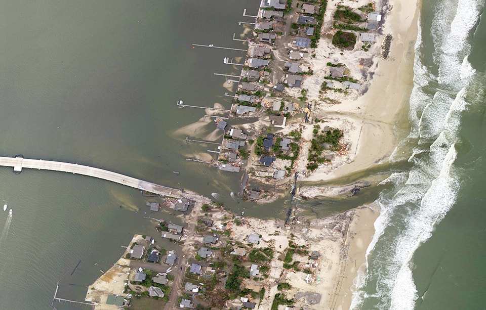
A new inlet cut across coastal Mantoloking, New Jersey by Hurricane Sandy. Image by NASA Earth Observatory
The damage wrought on the New York and New Jersey coast by Hurricane Sandy, the subsequent efforts to cope with that damage, and plans to put systems in place that could defend the coast against future storms all received significant media attention in the wake of the storm. But another topography scrambled by Sandy was much less reported, though it is essential to the economic life of the New York metropolitan area: the carefully-managed underwater contours of the harbor and its bays. After Sandy, ports along the east coast path of the hurricane were closed, including the Port of Virginia in Hampton Roads and, of course, the Port of New York and New Jersey, in large part because the underwater approach terrain leading to those ports, usually groomed by dredgers to match the lines delineated on NOAA’s navigational charts, had suddenly been rendered uncertain, potentially containing hazardous underwater debris or otherwise blocked by storm-induced shoaling. In order to re-open the ports, NOAA deployed its “navigation response teams” to urgently re-chart harbor bathymetry, in a vital act of emergency landscape measurement [6]. After the surveys were completed, the emergency dredging began, repairs to ensure that no unseen hazards would interfere with the arrival and departure of container ships, oil tankers, and the other commercial vessels plying the harbor [7].
Dredging, the very activity that restored the clean geometries of the harbor channels after the storm, is, in conjunction with a range of other sedimentary handling practices, also responsible for exacerbating the damage produced by the storm. If, as we contend, dredging constitutes a sedimentary infrastructure essential to the functioning of contemporary coastal urban systems, then the first important thing to recognize about this sedimentary infrastructure is that it is rife with feedback mechanisms. To illustrate this, we’ll turn to Jamaica Bay.
Dredging Jamaica Bay
Jamaica Bay is an isolated body of water that lies between the Rockaways and the mainland of Brooklyn, connected by a narrow gap to the main estuarine complex of the New York Harbor. It has been dredged since the mid-19th century, when private firms such as the Canarsie Railroad, White’s Iron Steamboat Company, and the Knickerbocker Steamship Company dug out small channels to facilitate their operations around the rim of the Bay [8]. Dredging in the Bay accelerated and intensified at the turn of the century, with the 1907 “Report of the Jamaica Bay Improvement Commission,” which recommended transforming the Bay from a marshy estuary (by then heavily contaminated by the waste of the burgeoning New York metropolitan area) into an enormous port, which would have been larger than Rotterdam, Hamburg, and Liverpool combined [9].
Jamaica Bay, 1898 USGS Map
The port scheme, which called for the consolidation of the Bay’s many marshy islands into two massive concrete islands and the construction of a vast array of piers, was never fully realized. Nonetheless, the plan guided decisions about the Bay for over two decades, so that by the 1930s a massive sedimentary transfer had taken place. Channels, slips, and basins — fifteen, eighteen, thirty feet deep, and hundreds of feet wide — were excavated from the shallow Bay bottom. The excavated sediments were piled onto adjacent islands and marshes, most notably being used to construct Floyd Bennett Field, an early airport that is now a component of the National Park Service’s Gateway National Recreation Area [10].
This transfer roughly fixed the current form of the Bay: a deep circular channel lines the outer edge of the Bay, separating remnant marsh islands in the middle of the tidal estuary from constructed terrain on the mainland, including massive paved tarmacs at both Floyd Bennett Field and its successor, John F. Kennedy International Airport. This is the configuration delineated by NOAA’s Navigational Charts, the configuration that the Army Corps dredges to maintain, battling continual refill from loose sediments washed in from the Bay’s watershed.
Jamaica Bay, 2011 Navigational Chart. Image by NOAA
This maintained form enables the mix of activities currently found in Jamaica Bay, including recreational boating, commercial boating, and various adjacent land uses. The maintained form is also deeply problematic, as the “dredging of navigation channels” is among the complex of factors pinpointed by scientific studies as being responsible for a sharp decline in the quality and quantity of marsh found in the Bay [11]. Surveys of the Bay’s island marshes found that over half their total area disappeared in the twentieth century. Predictions for the fate of the marshes over the course of the coming century vary, but are unified in predicting alarmingly rapid rates of collapse, often total disappearance of marsh within two decades [12]. Most of the other causes believed to be contributing to this degradation (which we’ll return to) also have human origins.
Marsh loss is not merely significant as a historical anecdote, but also because of the variety of important roles that the marshes play. Jamaica Bay was and, even with the loss, is still the largest tidal wetland complex in the New York metro area, acts as habitat for over eighty fish species, and is an important stopover for migrating birds. Because of these assets it is recognized as “a unique recreational, aesthetic, and cultural resource for New York City” [13] and “the only national park in the United States you can reach by subway” [14]. In Hurricane Sandy and other major storms, the marshes provide critical flood protection for nearby businesses and residences, slowing and reducing storm surge [15]. As most of NYC’s low-lying vulnerable population is located in the Jamaica Bay watershed (and actually predicted, by hydrological models, to become more, not less, vulnerable to storm surge if proposed barriers inside the Verrazano Narrows are built), this protective value is difficult to overestimate [16]. Moreover, not only does the anthropogenically-reorganized bathymetry of Jamaica Bay contribute to the loss of marshes which could ameliorate storm surge, but that reorganization itself has increased storm surge within the Bay, by deepening the once-shallow entrance [17].
It is important, though, as we mentioned earlier, to recognize that the blame for this situation cannot be laid entirely on the design of the channels in Jamaica Bay or on the dredging activities that maintain them. Dredge is implicated in this process, but studies suggest that a wide variety of human activities bear collective responsibility for the problem: reduced sediment inputs due to urbanization, sediment toxicity killing marsh plants which would otherwise hold sediments together and stabilize the islands, poor water quality owing to nitrogen discharges at the wastewater treatment plants that ring the Bay, boat traffic, and sea level rise resulting from anthropogenic climate change.
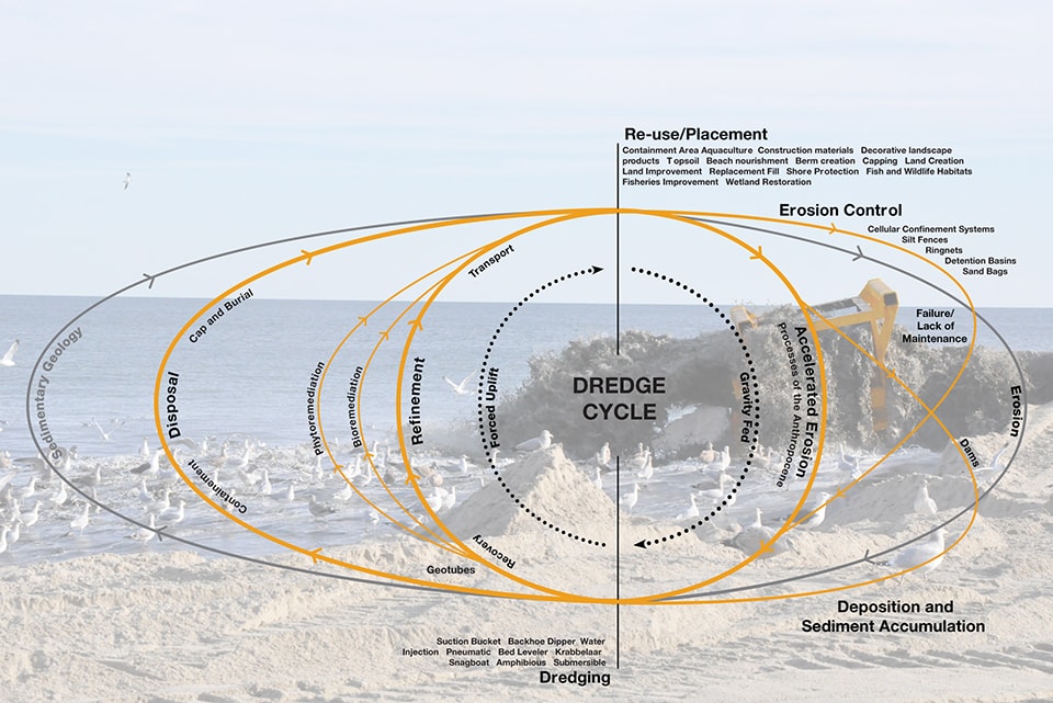
This suggests a second vital characteristic of dredging as sedimentary infrastructure: it can only be properly understood within the context of the wider set of human activities that manipulate sediment. Dredging is a key moment, but never an isolated moment. It is connected through the movement of sediments to a vast array of other processes and landscapes: erosion control technologies like silt fences and cellular confinement systems; dams, arresting vast quantities of river-borne sediment; urbanization, agriculture, and deforestation, all accelerating erosion; techniques of recovery, remediation, and disposal; and landscapes and other products made from the sediments collected in dredging, from new islands to decorative urns. Each of these landscapes and processes sees human activity affecting and precipitating sedimentary movement. Collectively, these manipulative acts can be understood as a cycle, analogous in scope and ambition to familiar natural cycles such as the water cycle and the rock cycle, though operating with much greater speed [18].
Quickened Geologies
We—the Dredge Research Collaborative [19] — refer to this relatively new sedimentary cycle as the dredge cycle, to emphasize the key position of the activity of dredging within this set of anthropogenically-influenced earthmoving processes. Dredging is the switching point in the cycle between erosive processes driven by gravity and uplifting forces driven by the input of energy to move sediment against the force of gravity. Dredging is also the point of the most intense and rapid movement of sediment within the cycle; if human influence over sediment is one of the ways that we behave as geologic agents, then dredging is the point of initiation for our most overt acts of artificial sedimentary geology.
But our influence as geologic agents goes well beyond the sedimentary. Within geology, biological sciences, and environmental studies, there is established awareness that human alterations of biogeochemical cycles, such as the nitrogen, phosphorous, and carbon cycles, have transformed the planet at a global and geologic scale. This awareness has recently coalesced around the notion of the Anthropocene, a new geologic era characterized by man-made planetary change. First proposed in 2000 by geologist Paul Crutzen, the Anthropocene is increasingly recognized as a useful way to understand the scale and intensity of human influence on global systems, “capitalizing on the way in which [the term] dramatizes the sheer scale of human activity,” “elemental in its force” [20]. The Anthropocene re-orders our relationship to landscape, forcing us to recognize that anthropogenic influence is pervasive and endemic, and consequently, caring for the function and resilience of landscape systems cannot be limited purely to reducing human impacts [21]. We are far too enmeshed within such systems to ever be able to extricate ourselves. Thus, wherever possible, human inputs can and should be opportunistically designed and utilized to improve upon degraded biogeochemical systems, building better and more inclusive natures.
The dredge cycle. Image by Dredge Research Collaborative
In a limited fashion, one such synthesis is currently underway in Jamaica Bay. Recognizing the degradation of the Jamaica Bay salt marsh islands complex, a complicated network of federal, state, and local entities have entered into a partnership to actively rebuild several of the bay’s most severely degraded islands utilizing sand dredged from the New York Harbor [22]. Ironically, but perfectly appropriately, the majority of the sand being used for this marsh-building project is only available as an unintended consequence of a massive earthmoving project over two thousand miles away: the Panama Canal Expansion Project.
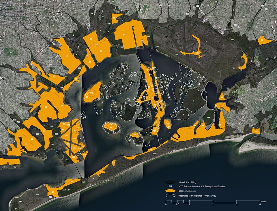
Jamaica Bay Anthrosols. Image by Dredge Research Collaborative
The Expansion Project, which will permit the Canal’s locks “to handle “New Panamax” ships — 25 percent longer, 50 percent wider and, with a deeper draft as well, able to carry two or three times the cargo” that the largest ships that can currently transit the Canal carry — is expected to significantly “alter patterns of trade,” “mean[ing] faster and cheaper shipping of some goods between the United States and Asia.” On the East Coast, the imminence of the Expansion has meant immediate and intensive pressure on ports to “deepen harbors and expand cargo-handling facilities” to accommodate the New Panamax ships that should begin docking in 2015 [23].
For the Port of New York and New Jersey, this has translated into a massive rise in the amount of dredging done in the harbor. Before Panama began the Expansion Project, the Army Corps dredged hundreds of thousands of tons of sediment from the harbor annually; since the Expansion Project began, the Army Corps has dredged millions of tons of sediment in New York Harbor annually, in a more than ten-fold expansion [24]. This dredging surge has been composed of sandier and cleaner sediments than maintenance dredging, which typically involves more polluted silts recently washed in from upstream sources. While only a small portion of this vast new stream of sediment has been diverted to Jamaica Bay for marsh building, without the quantity and quality of material dredged in the Expansion Project, there most likely would not be a marsh rebuilding project. The same kind of globally-networked commercial pressures that are implicated in the degradation of the marsh islands are now making possible their resuscitation. These relations are typical of the dredge cycle, full as it is of feedback loops that can be directed to either accretionary or erosive ends.
Sediments of the New York-New Jersey Harbor Estuary
The marsh-building projects, as beneficial and useful as they are, represent a relatively limited example of the redirection and reconfiguration of feedback loops within the dredge cycle toward the synthesis of new functional and resilient landscapes. A broader and more creative synthesis requires, at a minimum, an expansive understanding of the larger geographic and sedimentary context of dredge operations in the Harbor estuary. In preparation for an event we organized in New York City last fall — DredgeFest NYC — the Dredge Research Collaborative undertook research intended to begin to describe such a wider context.
Like all harbors within urbanized territories, the estuary receives additional sediment from anthropogenically-accelerated erosion. The main sources for these streams of accelerated sediment are processes of agriculture and urbanization taking place within watersheds feeding the harbor (primarily the Hudson, Raritan, and Passaic). While globally other major contributors to accelerated erosion include mining and deforestation, those processes contribute minimally to the New York-New Jersey harbor estuary.
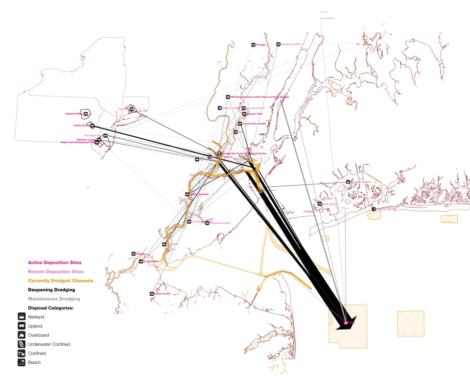
Dredging the Estuary. Image by Dredge Research Collaborative
Using tabulated data from US Army Corp of Engineers New York District [25], we mapped dredge operations in the harbor estuary from 2009 to 2012, showing both locations being dredged and locations where that dredged material was re-deposited, within the harbor and beyond.
That mapping shows that most harbor dredge material is currently applied to the HARS, or the offshore Habitat Area Remediation Site, as a remedial cap atop an underwater mountain of last century’s contaminated wastes, known affectionately as the Mud Dump Site [26]. Like the sediments being applied to construct salt marsh in Jamaica Bay, the majority of this dredge cap comes from the deepening of the harbor’s shipping channels to accommodate the larger ships associated with the Panama Canal Expansion. Once the capping of the HARS site is complete, a new deposition location for the majority of the Harbor’s dredge material will be required. Some of it will likely find its way to wetland restoration and beach nourishment projects. Other sediments will be applied to various post-industrial remediation sites around the region, typically as caps for contaminated soils on heavily toxic sites such as abandoned refineries and chemical processing facilities along the Chemical Coast. At greater distances, trains and trucks have carried loads of silt, sand, clay, and rock to sites as distant as abandoned coal mines in central Pennsylvania and the “Tire Pond” near Hartford — quite literally, a pond that was choked with millions of illegally dumped tires. Such unusual uses can be expected to account for some volume of future dredge operations. The rest is still unknown and yet to be designed.
DredgeFest NYC
This potential within the dredge cycle, the possibility of redirecting or even reinventing these feedback loops to generate new landscapes, new ecosystems, and new infrastructures, led the Dredge Research Collaborative to conceive of a participatory event series. We have observed that there is a growing interest in dredging and related landscape processes within design fields. We have also observed that this interest has remained primarily speculative, in large part because of a scarcity of working relationships between landscape architects and those actors with practiced agency in the landscapes of dredge. In an effort to grapple with these limitations, we launched our event series in the fall of 2012 with DredgeFest NYC.
Hosted by Columbia University’s Studio-X NYC, DredgeFest NYC brought together corporate practitioners, government agencies, scientists, designers, theorists, industry experts, and the public to talk about dredging and how it manifests in the New York/New Jersey region. The intent of the public event was to open up a conversation about the dredge cycle, at once documentary and speculative, while using the event as an opportunity to build connections between disparate communities and to frame new design questions. DredgeFest NYC had three main components: fieldwork and research preceding the event (products of which included both an exhibition at the symposium and on-going work with videographers Ben Mendelsohn and Alex Chohlas-Wood on a documentary about the dredge cycle), a public boat tour [27] (which visited landscapes of dredge around the harbor from Manhattan to Jamaica Bay), and a symposium, itself composed of three topical, interdisciplinary sessions (“Dredge and the Anthropocene,” “Circularity and Feedback,” and “Regeneration and Public Participation”) [28].
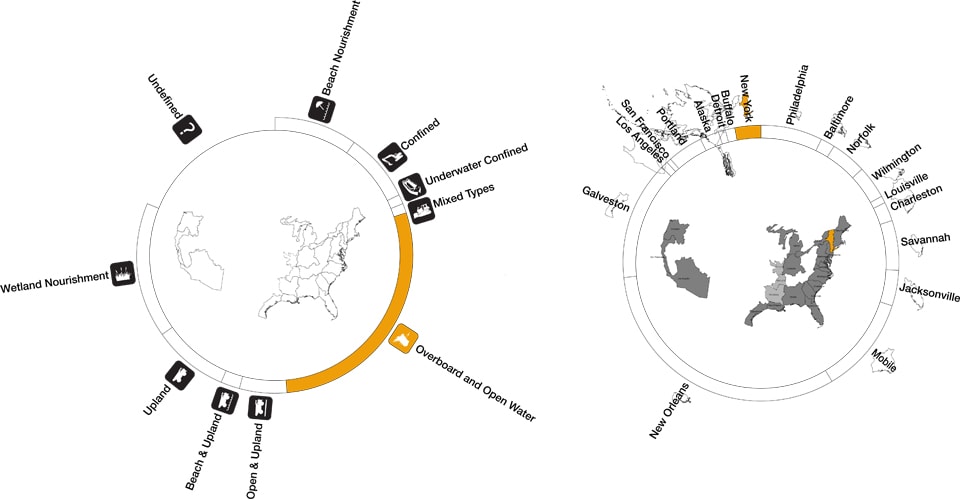
Volume: The relative volumes of sediments dredged in every Army Corps District that recorded a cumulative total of two million or more cubic yards of dredge activity between 2009 and 2011 [29] [left];
Disposal: Classifying the method and location of disposal for sediments dredged nationwide between 2009 and 2011. [right]
Images by Dredge Research Collaborative
Dredge and the Anthropocene asked, are there limits to an ever-expanding anthropocentric geology? The Army Corps of Engineers discussed their mounting challenges in maintaining New York’s ever-deeper Harbor, while University of Maine geologist Roger Hooke presented us with timelines quantifying the exponential growth in the amount of earth humans move per capita per year as observed through history. Ominously, there was no clear answer to the underlying question.
Circularity and Feedback investigated new and experimental methods for working with sedimentary flows, methods that attempt to grapple with current environmental challenges, waste streams and operational contingencies. From the EPA’s “Beneficial Use of Dredge” and the NY/NJ Sediment Decontamination Demonstration Programs (1994-2008), we learned that there are no established design frameworks for physically manipulating, detoxifying and transporting sediments at a regional scale. The unpredictable nature of dredging cycles and volumes, combined with other logistical uncertainties, render sustainable models of dredge decontamination choreography as yet still speculative. The underlying message here was that increased analytical and forecasting rigor is required if we are to shift from hard or static infrastructures to those that are more responsive and resilient.
Regeneration and Public Participation explored sediment manipulation as a potential platform for environmental regeneration and grassroots organization. Is there design of dredge outside of federal and corporate entities? The growing movement of citizen gardening of oysters (for the creation of reefs to stabilize channels and improve water quality, rather than for gastronomical consumption) and community efforts to regenerate the industrial banks of the Gowanus Canal demonstrated that public participation in the dredge cycle is already happening, and offers alternative potentials to top-down design of the dredge cycle.
Over the course of DredgeFest NYC it became clear that dredging in the NY/NJ harbor, as a process and set of operations, has evolved in conceptualization from an isolated and rather simplistic proposition (a linear act of industrial engineering) toward awareness of its ever-aggregating scope and influence—towards a recognition of the broader context of the dredge cycle, though not typically articulated in those terms. The management of sediments is now matriculated through extensive regional plans and strategies that include multiple stakeholders and a variety of agendas, including community and environmental concerns [30]. Dredged material is increasingly understood as a resource, rather than a waste. Yet dredging and other dredge cycle processes are still implicated in steep challenges, including legacies of toxic sediments, logistical and economic hurdles (many options exist for the reuse of dredged sediments, but few are as cheap as disposal at HARS), compartmentalization into political and disciplinary silos, and adapting to effects induced by climate change.
Yellow Bar Hassock, a salt marsh island in Jamaica Bay currently being expanded by the application of dredged sediments. Drawings by Gena Wirth, interpreting aerial balloon photography by Gena Wirth (Public Laboratory) and Rob Holmes (Dredge Research Collaborative).
800 PM EDT MON OCT 29 2012
A mere month after DredgeFest NYC, Sandy, at this point a “post-tropical cyclone,” makes landfall in southern New Jersey, [31] having already battered the eastern coast of the United States for hours, with the area around New York harbor, including Long Island, Staten Island, the Jersey Shore, Brooklyn, and Lower Manhattan particularly hard-hit.
In the wake of the storm, the pivotal role of New York’s sedimentary infrastructures in both enabling commerce within the harbor and serving as bulwarks against and dissipaters of storm surge was highlighted, shedding new light on the urgency of the task of understanding and contending with climate change, coastal resiliency, and the dredge cycle in tandem. A wide variety of responses to the storm have been broached in the press by politicians, designers, engineers, and scientists: multi-billion dollar surge barriers permanently emplaced in the harbor [32]; home buyouts in flood-damaged areas with the intention of retreating from the most heavily impacted zones [33]; “grassy network of land-based parks accompanied by watery patches of wetlands and tidal salt marshes,” as well as “breakwater islands made of geotextile tubes and covered with marine plantings” [34]; strategically hardening infrastructures to better absorb the impact of and ride out flooding when it does occur; and “a system of artificial reefs in the channel and the bay built out of rocks, shells and fuzzy rope that is intended to nurture the growth of oysters,” “nature’s wave attenuators” [35].
If events such as DredgeFest NYC and the conception of the dredge cycle have something unique to offer in this conversation, it is recognizing the quasi-designed linkages between multiple anthropogenically-driven landscape processes, be they dredging itself, beach nourishment, the Panama Canal Expansion, wetlands both eroding and accreting, coastal development, or sea level rise and ever-increasing frequencies of intense storms. Observing and acting upon these networked material relations is at least as critical to the resilience of urban systems as dealing with any individual component in isolation. The salt marshes of Jamaica Bay shrank for a hundred years without any human intervention intended to ameliorate or reverse that shrinkage. Restoration work only began when a seemingly unconnected event in a distant country, the Canal Expansion, produced a sudden surplus of suitable sand, and engineers and scientists opportunistically seized the chance to utilize that surplus. Re-designing the dredge cycle for the Anthropocene will require observing, designing, and manipulating such feedbacks, harnessing their aggregate energy so that they strengthen rather than undermine systemic resiliency.
 Brett Milligan is an assistant professor in the Department of Landscape Architecture and Environmental Planning at the University of California, Davis. He is the writer and director of Free Association Design and a founding member of The Dredge Research Collaborative. His design and research investigations in shifting infrastructure of the Klamath River Basin were initially funded by a research grant from the Graham Foundation.
 Rob Holmes is currently the visiting Bickham Chair in Landscape Architecture at Louisiana State University’s Robert Reich School of Landscape Architecture. Prior to joining LSU, he practiced landscape architecture in Virginia and taught at Virginia Tech. He is co-founder of both Mammoth, which investigates infrastructures, logistics, landscape, and architectural possibilities in contemporary cities, and the Dredge Research Collaborative, which studies human sediment handling practices in the Anthropocene.
